
.jpeg.88e30b1573920286ceacf89f239564d2.jpeg)
wolfie09
-
Posts
17,315 -
Joined
-
Last visited
Content Type
Profiles
Blogs
Forums
American Weather
Media Demo
Store
Gallery
Posts posted by wolfie09
-
-
Rgem in typical fashion gives us 2"+ of liquid precipitation by Friday Eve before the band lifts north.. Unfortunately thermal looks marginal for beginning of this event..
-
 1
1
-
-
AccuWeather 4-6 feet..
-
1
-
-
Maybe first 30s of the season?
Edit : "officially" Coop came in at 39° on the 15th..
ThursdayShowers likely, mainly after 2pm. Cloudy, with a high near 60. West wind 13 to 16 mph. Chance of precipitation is 70%. New precipitation amounts of less than a tenth of an inch possible.Thursday NightShowers likely, mainly before 8pm. Mostly cloudy, with a low around 41. Chance of precipitation is 60%. New precipitation amounts of less than a tenth of an inch possible.FridayMostly sunny, with a high near 56.Friday NightMostly clear, with a low around 39.SaturdayMostly sunny, with a high near 61.Saturday NightMostly cloudy, with a low around 47.SundayA chance of showers. Mostly cloudy, with a high near 65. Chance of precipitation is 30%.Sunday NightShowers likely. Mostly cloudy, with a low around 52. Chance of precipitation is 60%.MondayShowers likely. Mostly cloudy, with a high near 62. Chance of precipitation is 70%.Monday NightA chance of showers. Mostly cloudy, with a low around 49. Chance of precipitation is 40%.TuesdayA chance of showers. Partly sunny, with a high near 60. -
Severe threat tomorrow..

-
Pretty dead in here lol
Get ready to enjoy some fall like weather..
")
.png.9ad9ad0f7596e59be4b69989f0e86e79.png)
.png.463991ce3e06709b0d6ec3906dfafc8d.png)
.png.c9c584afc4ab78b0282586b2576421f2.png)
-
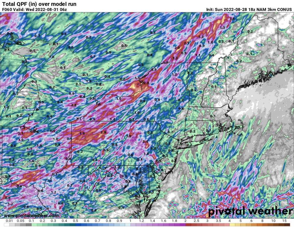
A strong mid-level trough will drop out of central Canada and cross the Great Lakes from Wednesday afternoon through Thursday night. As this trough tracks across these areas, it will deepen, and a strong sfc low will develop out ahead of the trough. With the developing sfc low, a trailing cold front will begin to cross the Great Lakes, including the Buffalo forecast area. Model guidance is all over with the timing of the crossing for this strong cold front, from anywhere from the early morning on Thursday to the late evening on Thursday night. The change in airmass from in front to behind the passing front will be tremendous with 850H temperatures crashing from near 20C down to near 0C in the matter of approximately 9 hours or so. Widespread showers (and at least a chance for thunderstorms) can be expected ahead of and with the front passing. With 850H temperatures expected to drop as much as they are, a lake response down wind of both lakes can most certainly be expected; but the finer details will need to be evaluated as we get closer in time (such as equilibrium heights, synoptic moisture, etc.) to know how strong of a lake response there will be. Temperatures for Thursday will be highly dependent on the timing of the cold front passage, if its later in the day, then Thursday will will likely be well above normal again, and vice versa for an earlier passing cold front. -
And we know who to thank..lol


-
A taste of fall Thursday and Friday..


-
2
-
-
Meteorological Fall has now started across the region. It won't feel like Fall today though, as temperatures will climb to within a few degrees of 80. The Climate Prediction Center suggests that mild weather will dominate this Fall season, as their three month outlook suggests above normal temperatures for the three month Fall season.

-
1
-
-
Looks about right lol
Pulaski is +2.2° but doesn't include the last few days...
+0.5° for the summer...
-
Crazy lightning with this..
-
1
-
-
You know we are getting there when we start to hear "lake effect rain"..
Even cooler air aloft arrives tonight, supporting the chance of a few more lake effect showers. The best coverage of showers will be east/southeast of Lake Ontario where better synoptic scale moisture/forcing will be found. Expect a band of lake effect showers to reach peak organization over Oswego County and the southern Tug Hill by late this evening, then break apart into scattered showers that drift south to areas southeast of the lake overnight as boundary layer flow veers northwest. Off Lake Erie, less available synoptic scale moisture and forcing will likely limit the lake response, with scattered showers across the higher terrain east of the lake peaking in coverage mid to late evening before ending overnight. -
The pattern will amplify across North America during the midweek
period, with a ridge building in the west and a sharpening trough
digging into the Great Lakes and New England. The trough will bring
a much cooler airmass into our region later in the week, with the
change in airmass marked by a strong cold frontal passage on
Tuesday.

The surface cold front will still be west of our region Tuesday
morning across Ohio and southwest Ontario, although a pre-frontal
trough and possibly a few remnant convective outflow boundaries will
support showers and scattered thunderstorms across our region
through the morning hours. Coverage of showers will increase from
west to east through the morning and early afternoon as the cold
front moves east into the area, and as DPVA/height falls spread into
the Lower Great Lakes ahead of the digging trough. A plume of high
quality Gulf of Mexico moisture will be drawn northward ahead of the
trough, with PWAT values approaching 2.0" just ahead of the cold
front Tuesday. The combination of ample moisture and increasing
forcing will support fairly widespread showers along and ahead of
the cold front Tuesday, peaking in coverage from late morning into
the afternoon.

Extensive clouds and showers starting early in the day will inhibit
destabilization, especially across Western NY. There may be a better
potential for a longer rain free window from the Finger Lakes to the
eastern Lake Ontario region. Relatively modest 20-30 knot deep layer
shear may support a few isolated strong storms in the afternoon with
gusty wind potential, if sufficient destabilization occurs over
eastern portions of the area. Any thunderstorms or heavier
convective showers will produce locally heavy rainfall given the
high PWAT environment. There appears to be enough steering flow and
eastward cold frontal push to limit residence time of heavy rain
over any one area, keeping the flooding risk relatively low (but non-
zero).

Showers and scattered thunderstorms will taper off from west to east
late Tuesday afternoon and evening with the passage of the cold
front. The mid level trough axis and associated strong vorticity
maxima will cross the lower Great Lakes later Tuesday night. The
trough itself may produce a few spotty showers. Cooling temperatures
aloft combined with very warm late summer water temperatures may
produce a lake response, with lake enhanced showers over and east of
Lake Erie and Lake Ontario later Tuesday night through Wednesday
morning. Forecast soundings suggest enough instability over the
lakes to support some thunder potential as well.

Wednesday any remaining lake effect showers in the morning will
mostly end, although there may still be a spotty shower east of Lake
Ontario into the afternoon. Wednesday night, a secondary cold front
and another shortwave will cross the Lower Great Lakes. The influx
of even cooler temperatures aloft, some added synoptic scale
moisture and ascent, and convergence along the secondary cold front
will bring a renewed chance of lake effect showers over and east of
the lakes, with a chance of some isolated thunder as well.
-
On 8/27/2022 at 9:56 AM, wolfie09 said:
Rain chances increase Monday night/Tuesday..
.gif.0a4dcb96d4bc8fdc62539c22212be9c5.gif)
.gif.4e195e4b33a71750cd1595257396744b.gif)
-
Rain chances increase Monday night/Tuesday..
-
Probably around a dozen or so showers over the past few days.. Equalled out to 2" of precipitation..

-
1
-
-
Nice little soaking this morning, starting to clear out now..Let's see what this afternoon brings...

-
-
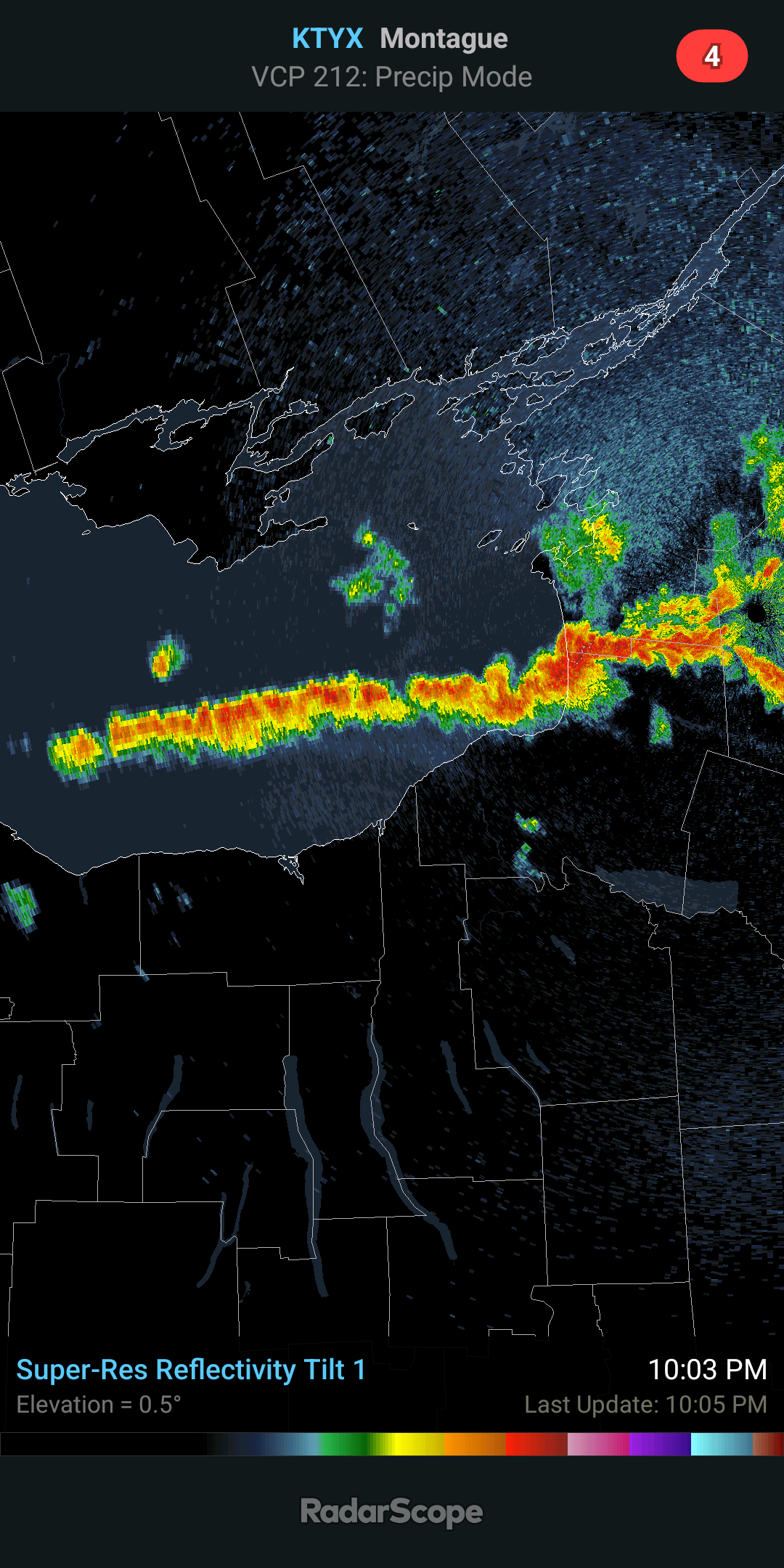
Damn that lake is a furnace..lol This is 2am Thursday into Friday...N/NW winds obviously..

-
Sizzle sizzle lol BW nailed it..
Relief is on the way thankfully for us non sizzle fans lol
The oppressive heat and humidity of the past several days will finally come to an end, as cooler and gradually less humid air will move into our region behind a cold front late tonight and Tuesday. The front will generate some showers and thunderstorms with heavy rain in the process. A change to truely more comfortable weather will not move in though until Thursday evening.

-
While it can happen it's also extremely rare, even for the lower elevations of Oswego... Usually comes more from lake enhancement behind a retro low..Hard to get those numbers with pure lake effect..
-
1
-
-
You can see as we head farther into winter the flow starts to turn more NW/Wnw Especially during the day..

-
Obviously this doesn't have 100% data and a normal wind direction is out of the west.. But you can see especially overnight W/WSW rules the day in Dec..

-
 1
1
-
-
4 minutes ago, BuffaloWeather said:
All the long range models show December as the below average month.
Well if there is any month to be below average I hope it's December lol Tired of these slow start winters..Hard to catch up with minimal snow through December...
-
2
-


.gif.2b9434df75c4edb4362a525f0dad487d.gif)


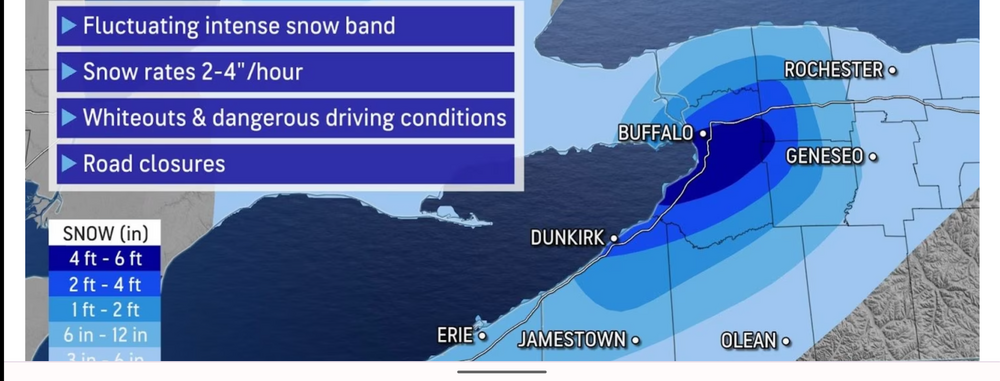
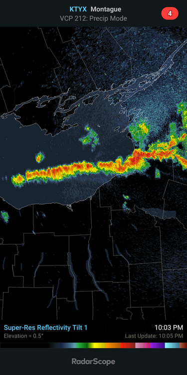
Historic Lake Effect Event?! 11/17-11/21
in Upstate New York/Pennsylvania
Posted
Case in point..lol