

outflow
-
Posts
290 -
Joined
-
Last visited
Content Type
Profiles
Blogs
Forums
American Weather
Media Demo
Store
Gallery
Posts posted by outflow
-
-
Power outages are going up fast across se mi with 33,000 for dte energy now. Trees are really stressed already up here in the thumb and starting to loose some bigger limbs. Probably about 3 inches so far
-
 1
1
-
-
Haven't been looking at this as closely as normal, what's the upper end wind potential along the lakes looking? From my brief look. I'm guessing 50-55mph?
-
16 minutes ago, cyclone77 said:
December is usually just a 2nd November anyway the past decade or so. Good news is we get a 2nd March to help make up for it if you like cold weather.
I could deal with a third, fourth, and fifth November or any month for that matter if it came with something interesting instead of the endless zzzzz much of the great lakes area seem to be stuck in.
-
1
-
-
18 minutes ago, TheClimateChanger said:
I'm beginning to think large portions of the country will be uninhabitable during summer by later this century due to increasing heat and humidity.


-
 1
1
-
-
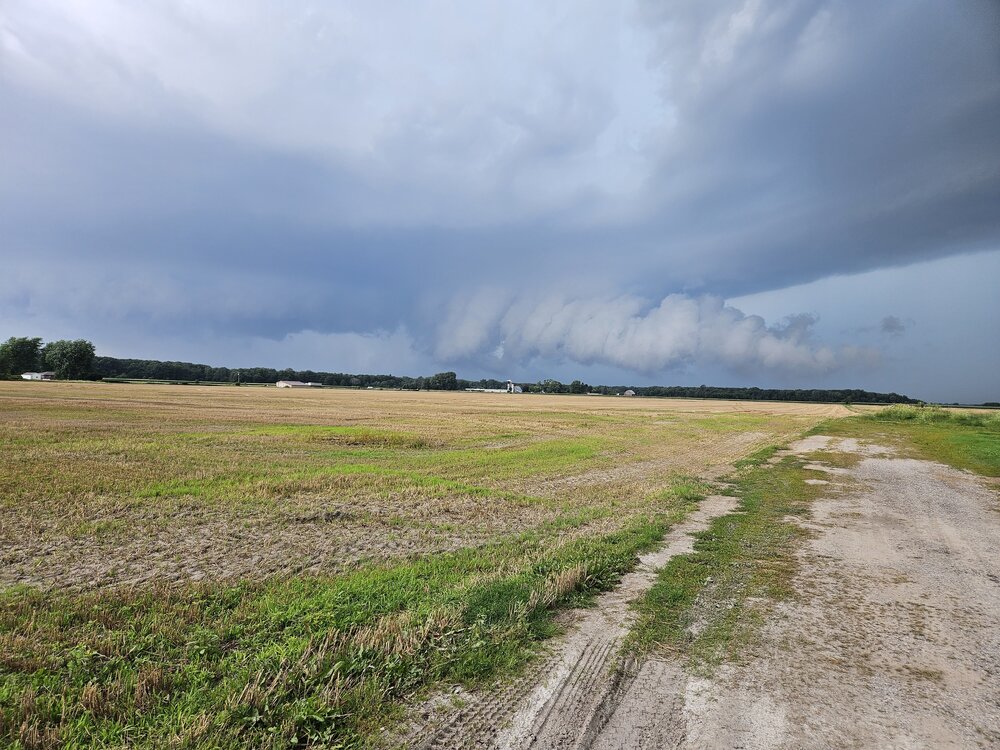
Fun little cell yesterday afternoon came across Saginaw bay and tried very hard to produce as it came onshore with about a 10 minute window when it had wall cloud with rapid motion before becoming wrapped in rain and outflow dominant. Produced some 60-70 mph gusts as it came overhead with lots of tree damage. Nice little local marginal day.
Looking from the se to nw before I moved and the storm tightened up
-
7
-
1
-
-
8 hours ago, Stebo said:
If we don't get any junk convection over IL tonight
It's like mother nature seen this and said hold my beer.....
Side note it still amazes me how summertime convection can make humans and computers look completely clueless when it comes to forecasting even 12 hrs in advance, but in the same sense it wouldn't be as fun if we knew exactly what would happen would it
-
16 minutes ago, Harry Perry said:
Thinking that the best shot for severe will be closer to Metro Detroit later on today. Lots of clouds and the decaying mcs is out running the better support over this way.
I think the severe chances, besides some low end risk over the next 1-3 hrs, are highly in question just about anywhere in the enhanced risk area with this first mcs coming through before the better support and dynamics come into play later this afternoon. There will have to be a quick recovery in order for another round to fire and have a chance at some higher end potential.
At least there is another widespread rainfall to continue to erase drought concerns.
-
1
-
-
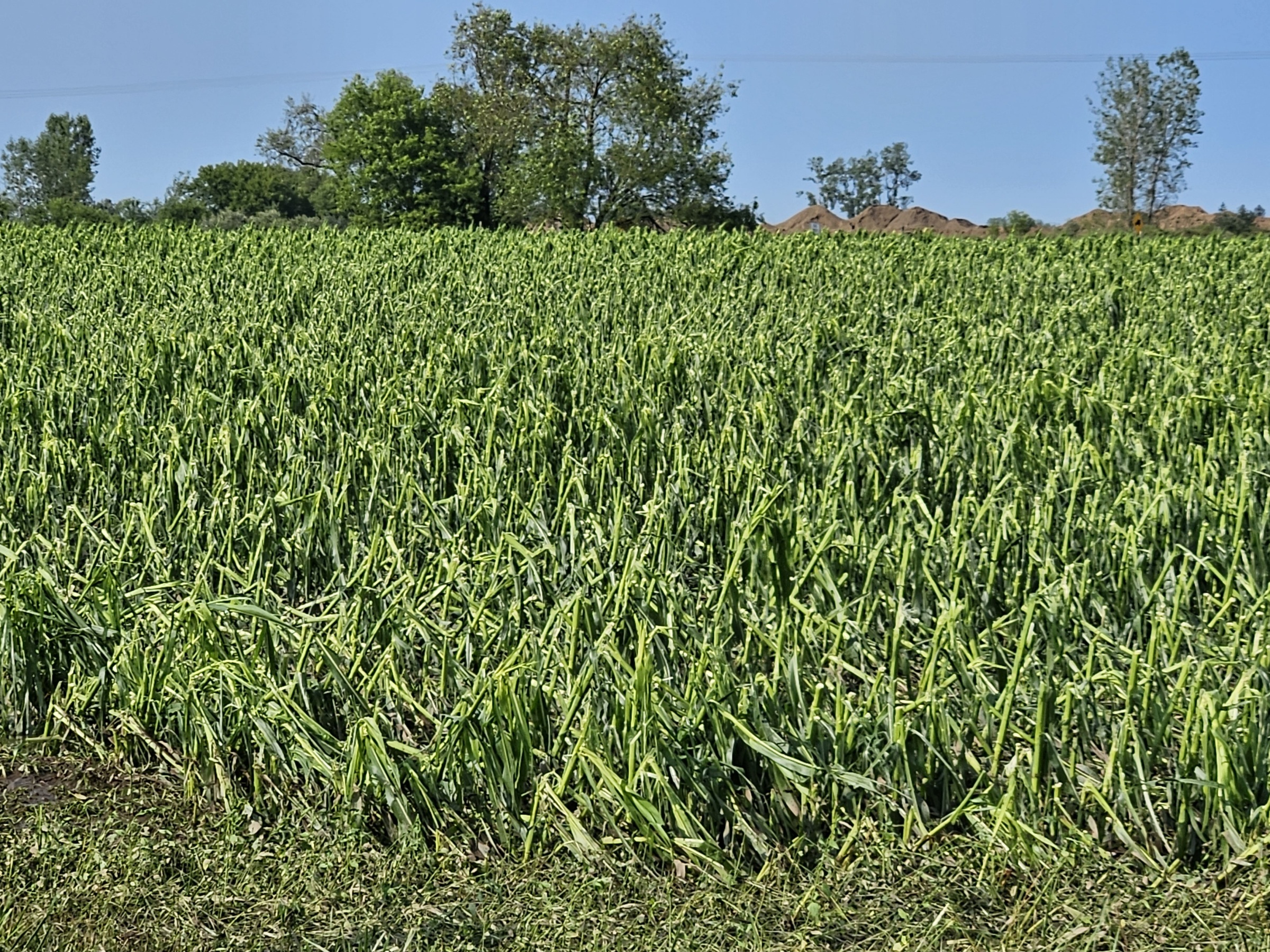
9 minutes ago, Baum said:
lawn needs a cut
Nearby corn got cut....

-
1
-
 1
1
-
-
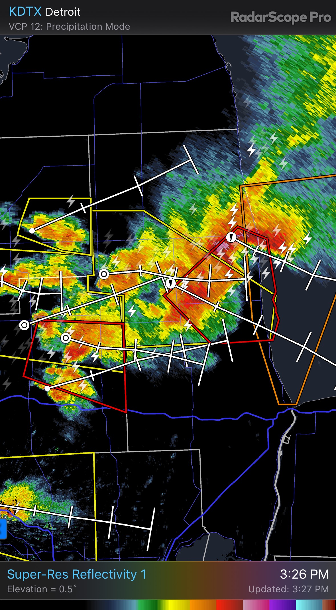
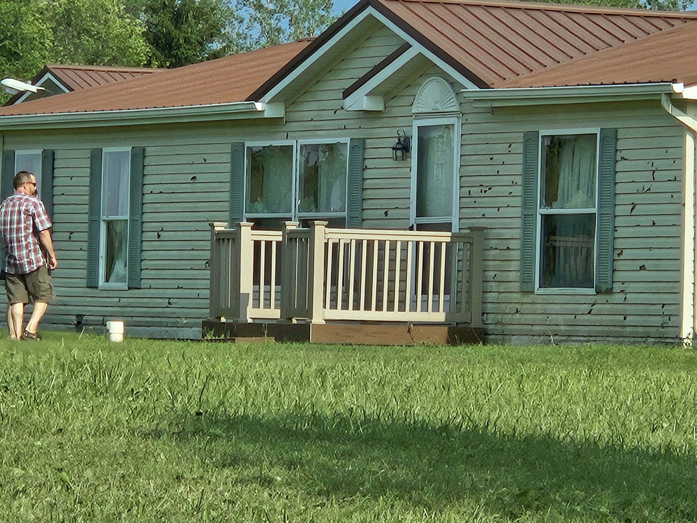
4 hours ago, SolidIcewx said:
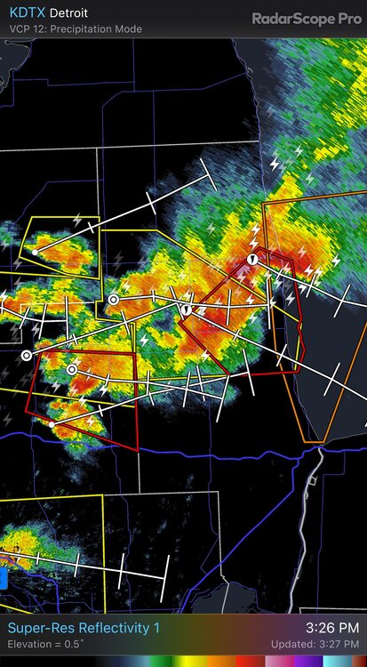
Lots of tree damage in that area along with wind driven hail damage. Couldn't keep in front of it when it finally got tight around the village of Applegate, got a late start and played catchup having to drive in through all the heavy rain.

-
3
-
-
3 hours ago, A-L-E-K said:
Pulled off the classic and seamless drought to flood headlines transition
Pretty much a given if there is a giant event happening, nascar race, that requires good weather it will rain the entire time.
-
1
-
1
-
-
Worst I have ever seen it today in mi thumb, it's even hazy inside our shop today with the overhead doors open.
-
Its the monotony of this pattern that is the worst, it's like living the same day over and over. Hell, I'd take a 55 degree cold light all day rain every few days just for a change of pace.
-
 1
1
-
 1
1
-
-
First thunder in forever just now, rocking the typical 65/53 temp/dewpoint you would expect for June thunder. Trace of rain so far
-
2 hours ago, SolidIcewx said:
Air quality starting to go downhill in Michigan from north to south. Looking like it’s slowly creeping into the lower half of the peninsula
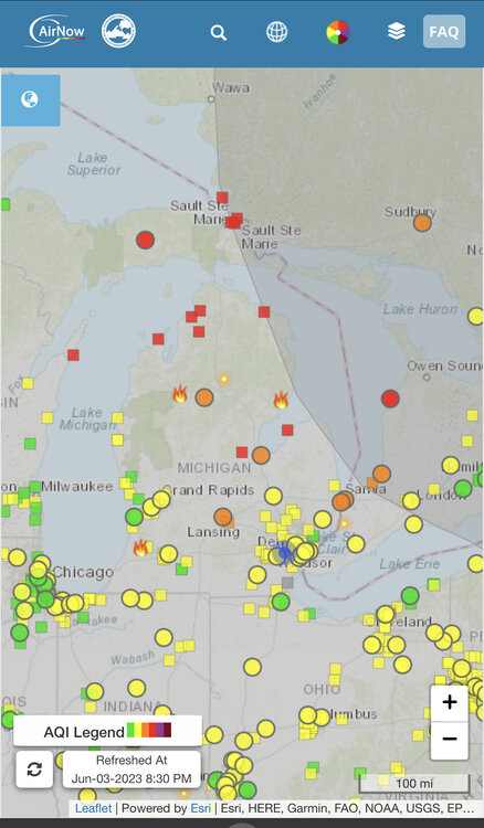
There was/is a 3500 acre wildfire near grayling that has shut down i75 for most of the day today
-
1 hour ago, A-L-E-K said:
feel bad for my guy with the bad timing, chasing of all kinds is really rich or retired man's game and thus not 4 me
At least as you get into later may and June you usually have daily activity off the front range to chase as a backup if there isn't any targets further east in the plains. It might not be high end tornado potential but you could still get lucky and also have some spectacular structure shots.
You try to plan a April or early May vacation you may end up with a week of cool and dry after a cold front plows Into the gulf the day before you get out there.
If I ever were to have the chance to dueba plains vacation it would definitely be the last week of May up to mid june
-
1 hour ago, Harry said:
That lake is gonna go nuts on Monday.
The boats fishing off the thumb in 20-50 feet of water are getting surface temps in the low to mid 50s today
-
1 hour ago, Lightning said:
I am not looking forward to this weekend being cold and snowless

At this point it's go massive or go home when it comes to cold/snow, 20s and mood flakes just don't cut it
-
2
-
1
-
-
10 minutes ago, Harry said:
The se trend can cease now.

No one wants a Canadian coup
-
2
-
-
6 minutes ago, Stebo said:
I expect DTX to go warning for their entire watch except Monroe.
Wwa for bay Midland Saginaw tuscola Huron imo
-
https://m.facebook.com/story.php?story_fbid=10160242926902559&id=83040292558
This is what it's been like going on 18 hours around this part of michigans thumb. I would guess 4 inches of snow but with the wind it's been very difficult to impossible to travel outside of towns. Sheriff's department early this afternoon stressed no travel unless an absolute emergency and wreckers and road crews were being pulled at dark. So despite that relative low snowfall totals it definitely will be one to remember locally for a while.
-
2
-
-
7 minutes ago, Harry said:
Just saw another image. See let's talk winter thread. Just north of Sandusky over the lake..
What the hell is the SWC and what drug were they on when they posted that best guess low track map
-
I see Hawaii is under a svr tstorm watch right now don't remember seeing that too often
-
2
-
-
7 minutes ago, cyclone77 said:
What a change from late this afternoon when summery convective clouds were rolling overhead. After being up near 60 we're down to 24 with a wind chill of 9 lol. Pretty intense caa this evening brought in by 45mph winds.
I always feeled robbed when such a dramatic shift in the weather comes with zero local interesting phenomenon like your dry frontal passage
-
1
-
-
41 minutes ago, Chicago Storm said:
they're at least good for providing severe t'storm wind damage.
Box elders are good for that too.


Jan 11-13th Blizzard
in Lakes/Ohio Valley
Posted
Me too, big limb fell ripped the service line off the house just a bit ago