

buckeye
-
Posts
8,772 -
Joined
Content Type
Profiles
Blogs
Forums
American Weather
Media Demo
Store
Gallery
Posts posted by buckeye
-
-
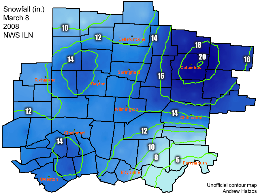
For a March snowstorm its lasting effect was solid. It got brutal cold for a couple weeks on its heels and the deep cover stuck around unusually long for the time of year.
As far as blizzard criteria, probably about an hour at the end the wind really kicked up and we had white out conditions…. But it didn’t last long. -
17 years ago and I lived under that 20” bullseye.
still paying the price for that one
-
 1
1
-
-
12 minutes ago, dilly84 said:
Cleveland took knox off yesterday, now back on and calling for the nice range of 1-4" lol
We’re north of 2” here imby already. I think between the rest of the synoptic and maybe some squalls later 3-5” on the ground by night is easily reachable
-
1
-
-
52 minutes ago, pondo1000 said:
Snow globe!!!! Go to bed with heavy rain & mud, then wake up to snow & white! Pretty outside!
Made no sense to me when ILN left their northern tier counties off the wwa. Pretty rough out there right now just like every model was showing yesterday.
-
36 hours ago several models were big dog’n Chicago thru Detroit. Now it looks like Chicago won’t see crap and Detroit will get a run of the mill advisory snow. If you can’t trust models 2 days out, wtf is the point? Crazy
-
1
-
 1
1
-
 1
1
-
 6
6
-
-
On 2/11/2025 at 6:32 PM, dilly84 said:
Wow, what a shame
I literally just saw this on a news feed and it was like 10 days ago. Ganahl was the goat of cmh weather. He moved to Columbus from Iowa during the infamous late 70s winters. I followed and watched him for nearly 45years from when I was in junior high school to becoming a grandpa. He was a huge snow weenie too, loved cold and snow. That’s why it was fun to watch him.
RIP Jym, May the blizzards be plentiful in heaven! -
19 hours ago, roardog said:
So while all of your friends were seeking out real porn, you were seeking out the rain/snow line.
I honestly don't know what would be more embarrassing as a teenage boy.....getting busted at 2am surfing pornhub or getting busted at 2am surfing the 00z euro run.
-
1
-
 4
4
-
-
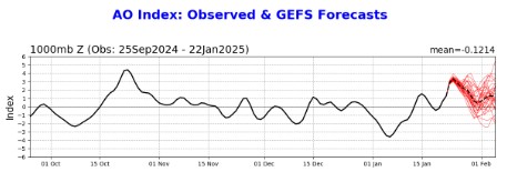
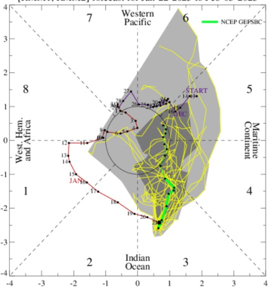
this one is more interesting to me. Highest probability is that it's too far north for mby, but it's a convoluted set up and seems like models are having trouble figuring out where the dominant low eventually forms and tracks. The nao will be neutral, the AO is in the tank, the PNA is positive, and the mjo will be in 8, so I don't think a cut up into the lakes is that likely, but still could come too far north for the i-70 crowd. Also depends on what this weeks storm does. Very rare to see back to back storms take a similar track within 72 hours of each other. Models love to show that kind of porn but reality is usually a different story. At least something to track though.
-
2
-
-
On 2/9/2025 at 1:54 AM, Stevo6899 said:
Back to back to back home runs on the euro. Probably will never see a run like that again locally, 40+ in 9 day span.
don't get too excited, this was a euro op run five days ago. Amazing how quickly 36.7" of snow can disappear. Don't even get me started on the ensembles either. They have been horrible. Consistent runs across the board from ggem, euro, and gfs all showing 20"+ for mby over the 360hr run, (multiple times last week). Incredible how bad they are.
I am glad to see our sub finally cashing in further north and west, even though cmh continues to miss south, north, and east. At least it's not the eastcoast getting it this time.
.thumb.png.666a93ef1c148827177f233624729fec.png)
-
1
-
-
1 minute ago, A-L-E-K said:
u win some u lose some
when are them wins com'n? Been a long time....really long time.
-
1
-
-
3 hours ago, michsnowfreak said:
Freezing rain (about 0.07") with temps in the 20s. Slick as snot on a brass doorknob.

if you combine the small pile in the foreground with the one in the background, your snow will last longer. #respectingthesnow
-
3
-
 1
1
-
-
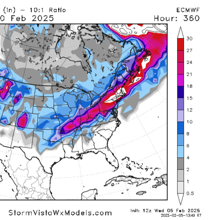
brutal year for the i-70 on north crowd...sitt'n on the bench sniff'n the northern edge.
-
Can we get one of these maps to be right…even just once a season? Hell even half right would be nice. (That’s the 360 hr euro snow total for 12z)
-
8 minutes ago, michsnowfreak said:
This is pretty close to correct. For the entire winter of 2023-24 & thru Jan 30th of the winter of 2024-25. The winter of 2023-24 saw 23.4", which is 21.6" below avg, and thru Jan 30th of this winter, the total of 14.1" is 10.2" below avg to date.
Of course we all have no idea how the rest of this snow season will play out, with nearly half to go. But I knew at some point we would pay for the excess snowfall. Doesnt make it any part of enjoyable, but you knew it had to happen at some point. In fact, the 1991-2020 averages are the snowiest of any 30-year period (45.0") due to so many snowy winters. The longterm avg is around 41".
The running 10 year avg snowfall of 40.9" is right around the longterm avg.
Our snow totals over the last several years must have crashed our average here in CMH. I didn't realize it, but CMH has not officially recorded a 6" or greater snowfall since 2015. I'm sure mby has touched or exceeded that but still, that's crazy.
-
1
-
 1
1
-
-
2 hours ago, Chicago Storm said:
long range “forecasting” for an entire winter or cold season is essentially just long range guessing. if you’re right, you got lucky. if you’re wrong, you were destined to be anyway.
these long range winter forecasts that are issued by many in the fall are the most pointless kind of “forecasting” there is. stick with getting the short term correct and worry less about the super long term.yup. On a humorous note, JB finally goes warm for the first time in, (almost ever), and look what happened. I mean, he has to HATE the fact that he never saw places like New Orleans and Pensacola having a record snow year...that's the wheelhouse he claims to OWN. Instead he got pwned. He'll never put out a warm forecast again lol.
-
3
-
1
-
-
20 hours ago, Harry Perry said:
Yeah, I’d imagine it’s going to be lots of rainers. Maybe some pingers. The pattern has been like this since November, we wait for the cold and wet at the horizon, and it keeps getting pushed farther back. We finally got the cold, short lived albeit but little precipitation (outside of lake effect). Now on the horizon, I see lots of early spring systems with much of the sub in the warm sector and really a bias for warmth through the end of the month. EPS weeklies looking toasty. Kind of reminds me a bit of last February - maybe we’ll get another middle of the night tornado outbreak with some golfball size hail come the end of the month.
have another drink....
-
4
-
-
36 minutes ago, Cary67 said:
6Z GFS looked icy. Hope that doesn't verify
it won't
-
1
-
1
-
-
On 1/29/2025 at 4:34 PM, michsnowfreak said:
You guys and these OP runs

These medium range snow total maps, whether they're Op or ens, are completely worthless regardless of the model. You would have more accuracy going to a corner psychic shop and asking how much snow, (and that's not sarcasm either).
On a broader note, I know some mets get bent when a weenie like myself says it doesn't seem like there's been any improvement to long range forecasting in the last 20 years, (and I know there are technical stats that would prove that wrong), but it's really hard for a weenie like myself to see improvement. It feels exactly like the same crapshoot it was when I started following this stuff in the early 2000's
This winter is a perfect example. I didn't see a single long range forecast for this winter made back in fall that came even remotely close to what's unfolded.
-
5
-
-
4 hours ago, michsnowfreak said:
For sure, although down there they literally have no concept of measuring snow haha. Could also be measuring on grass (which is undoubtedly lush and squishy) and sticking the ruler in too far. Wild storm.
Like my wife. We'll get 2" of snow and she be like, "omg, we must have like 8" out there!" Of course I never correct her, I simply nod my head to reinforce the illusion.
-
8
-
-
40 minutes ago, Malacka11 said:
Has there been a single run yet this entire season where the GFS in Euro actually depicted roughly the same evolution for a storm at more than 200 hours out?
NO
-
3
-
-
37 minutes ago, Frog Town said:
Yeah, I don't think this cold pattern is changing anytime soon. Maybe a relaxing of the pattern, which is what we all want for better snow chances, but not a big a warm up. Thinking mid to end of February for that. But even then I bet it's a slow warm up with a lot of ice chances.
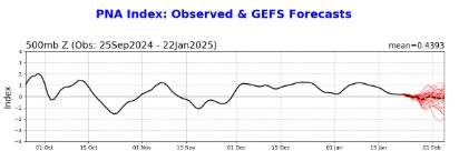
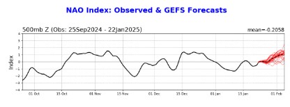
I mean anything is possible, (snowball fights on Bourbon Street for example), but I find it hard to believe we end up with a wall to wall cold January followed by the same for February. I mean we'd be talking about winters of yore. Models always seem to get stuck when a pattern persists...like trying to turnaround an aircraft carrier. I think once the warmth, (or at least milder), pattern actually starts arriving we'll start seeing the fantasy cold shots fading. But I agree the transition will bring some decent storm chances for the sub, probably transitioning to rain for us but better snow chances especially further west. The PNA is still impressively stubborn as hell but trying to break below neutral and the mjo is skirting the warm phases thru the COD as we get into the first week of Feb.
-
1
-
-
16 hours ago, nwohweather said:
It has been very odd. Suppression with no nor’eastersTrough too far east and always positively tilted, makes it tough to brew up a nor’easter.
-
Just now, Snowstorms said:
I've appreciated the consistent snow days. It's definitely made it feel like winter. While disappointing to see everyone getting a chance to score, our time will come.
Need to move that big ridge across the PNW towards the Aleutians and Alaska for the SE ridge to flex a little bit and help create a gradient. Our best and biggest storms come from patterns like that. EPS has been hinting at that near the end of January, but it keeps getting pushed back.
have to admit, we've had a snowcover now for quite awhile. Unusual in these parts. See how much rain we get Saturday and then if anything squally develops Sunday ahead of the next plunge.
-
1
-
-
5 hours ago, A-L-E-K said:
extended doesn't even look super cold, just boring
yea, the early week plunge is still very cold but the models have backed off of the stupid stuff. (edit: ggem still showing -28 in central OH
). I think we start seeing overall moderation in LR, with models backing off of the non-stop arctic plunges out of Canada. For snowlovers, especially in your neck of the woods that's probably a good thing anyways, better chance of lows cutting further west or on top of us.
-
1
-


4/2-4/3 Potential Major Severe WX Outbreak
in Lakes/Ohio Valley
Posted
I'm telling you, when we get enhanced or higher it's the kiss of disappointment. CMH is always on the eastern edge of every threat with the timing almost always during the overnight hours. I'm not holding my breath for anything too crazy locally tomorrow / tomorrow night. We shall see.