

Memphis Weather
-
Posts
519 -
Joined
Content Type
Profiles
Blogs
Forums
American Weather
Media Demo
Store
Gallery
Posts posted by Memphis Weather
-
-
This won't be Alpha either!
-
 6
6
-
-
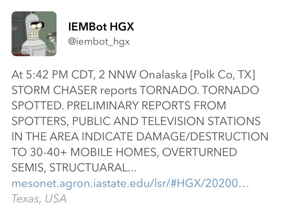
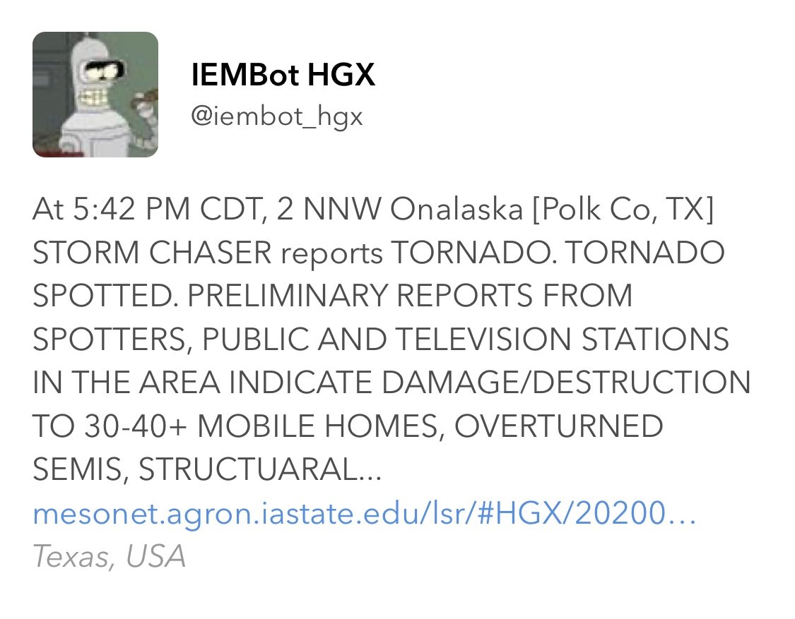
Regarding Onalaska....
-
 1
1
-
-
SUMMARY...SUMMARY BASED ON RECENT RADAR AND ENVIRONMENTAL DATA, A STRONG TO INTENSE TORNADO WITH POTENTIAL PEAK WINDS OF 130 TO 165 MPH (EF2-EF3) IS LIKELY ONGOING. DISCUSSION...DISCUSSION RECENT RADAR SIGNATURES FROM KGRK AS OF 2250Z REVEAL AN INTENSE SUPERCELL CHARACTERIZED BY A 0.5 DEGREE ROTATIONAL VELOCITY OF AT LEAST 70 KT. A TORNADIC DEBRIS SIGNATURE HAS ALSO BEEN NOTED ON RECENT RADAR SCANS. THESE SIGNATURES ARE OCCURRING IN AN ENVIRONMENT CHARACTERIZED BY STP BETWEEN 5 AND 6. PREVIOUS SIGNATURES WITHIN SIMILAR ENVIRONMENTS PRODUCED TORNADO-DAMAGE-ESTIMATED WIND SPEEDS FROM 130 TO 165 MPH AND CONFIDENCE IS HIGH FOR A STRONG TO INTENSE TORNADO. A LONGER-TRACK TORNADO IS ONGOING AND MAY CONTINUE BASED ON THE ROTATIONAL VELOCITY DURATION AND THE STORM MOVING WITHIN A FAVORABLE DOWNSTREAM ENVIRONMENT.
-
Looks like that one has roped out at least for the moment
-
Violent motion on this one. Sub vortices evident.
-
Just now, cheese007 said:
Where do you have it?
News 9 Live stream
-
Tornado continues to get larger
-
Fairly large cone on News 9 now
-
This is still the lead cell
-
 1
1
-
-
Anything less than full devastation in Soso or any of the other small communities that have already been hit would be a miracle. The debris fallout on Correlation Coefficient is unlike anything I've seen before....
-
Small TDS on that one NE of Godley
-
-
Per @NWSNorman - PDS Tornado Watch for much of Western/Central OK currently being coordianted
-
1
-
-
Potentially serious situation in Branson, MO. Reports of a sightseeing boat being capsized/sinking during a severe storm. Possibly 20-30 people in the water, rescues ongoing but there may be fatalities involved.
-
Multiple rather serious damage reports coming out of Goodman. Interestingly...no TDS has been indicated on radar. Not sure if perhaps damage could be related to RFD.
-
The quick turnaround is likely because this assessment was done on a regional level (Central Region) and not on a national level.
Ahh, that makes sense. Thanks for the info!
I have to say...its the best NWS assessment I've seen. Great coverage of the societal aspect. I'm interested now to see what the eventual changes will be...how a "impact-based" system is implemented. At the least...as CT Rain says...appears the Tornado Emergency is going to become a separate product...but appears even bigger changes will eventually come.
-
Joplin Tornado Assessment report is out!!!!!
Fastest turnaround I've ever seen for a NWS assessment...4/27 report isn't even out yet.
Many big statements in this one. Quotes that the warning system (and outdoor sirens) "have lost a degree of credibility"...and proposes a framework for basically a new warning system all-together.
Another major proposal...implementing a new 88D VCP that allows for one-minute 0.5* slices...
-
I have talked with Springfield NWS numerous times and did some walking through the damage path with them. The impression I got from them is that this is a solid EF-5. The winds probably varied a bit with in the tornado. I have walked every stretch of this damage path and I would say that parts of the it were strong EF-4 to low EF-5. Then there are segments of strong EF-5 that probably had winds at 250mph. If you walk every inch of the path you can see the parts that were just a hair stronger. So I believe that 70% of the path was probably 200-210mph winds. But there are segments of probably 225-250mph winds. Also remember this when you talk about St. Johns. This is a huge building that actually got shifted off of its foundation a bit. And St. Johns was on the edge of the tornado and didn't take the strongest winds. Also when it hit Rangeline (Home Depot, Walmart, Acadamy Sports) it was a hair weaker. Probably winds around 200 mph. If you walk that path numerous times you can see the wind varying in spots. I think that is why there is some confusion on this. The bottom line is this is the most deadliest tornado in modern history. You have to go back to the Tri-State tornado for more deaths. That tornado spanded over 200 miles on the ground. The Joplin tornado did all of this in a 6 mile stretch. Also the Tri-State tornado was prior to tornado warnings.
Thanks for some great clarification there! Seems that perhaps the 225-250 estimate is still valid then. Either way...no matter the exact speeds...its just a tragic and heartbreaking sight...and the stories of you...JoMo and others continue to be incredible. The fact remains as you say that this is the deadliest tornado of the modern era and that's the most important thing to remember in terms of historical perspective.
-
First off...I agree..."low-end" EF5 is not a good term to use...though I understand why it does get used. EF5 is EF5 by that point...but the implication is probably something between 200 and 210mph.
My main question is...why did the Springfield WFO MIC go on-air for a live interview to a TV station and explicitly state that they estimate the strongest winds at 225-250mph if that either wasn't true...or they just didn't have enough confidence to go with such a number yet. I would not have been expecting an MIC especially to throw out a number like that unless they were pretty sure of it (even if it never appeared on official statements)...so I think that's why it got reported so much that day when the interview aired. Even TWC was quoting that interview several times.
If it wasn't that strong...that doesn't bother me in the end...I do trust what all the teams have been doing on the ground there...which I can't imagine being tasked to do...but I would like to know how an MIC let that slip if it wasn't true or just wasn't credible to that point of the survey.
-
After being sidetracked for over a month with the historic flooding event and other severe weather...MEG has gotten around to building a much more extensive page for this outbreak...
http://www.srh.noaa.gov/meg/?n=apr2011toroutbreakhome
Included is a lot more detailed information about each tornado. In addition...their CWA-wide tornado count between April 25-27 has been raised from 14 to 21 (mostly just adding EF-0s). The 4/27 count itself is 16.
-
Wow!
Add to that the latest SGF wind estimates above...we clearly have the strongest EF-5 of the modern scale era...and probably somewhere in the discussion among the strongest tornadoes ever thought to have occurred.
-
JOPLIN, Mo. -- The National Weather Service provided additional insight into the decision to rate the tornado last Sunday at the top of the Enhanced Fujita Scale. The tornado was given an initial rating of an EF-4 before it was upgraded the next day.
Bill Davis with the National Weather Service said investigators look at structural damage and how far heavy objects were thrown. This tornado, for example, tossed concrete parking lot "bumpers" that sit low to the ground and can weigh up to 300 pounds.
The NWS investigators also noted that tractor-trailers parked near the Wal-Mart store were thrown farther than 1/8th mile. Manhole covers were also lifted and tossed.
The tornado's path is an estimated six miles long. It's from three-quarters of a mile to a mile wide at some points. The winds are estimated to have briefly hit between 225 and 250mph.
-
I'm very sure the NWS will do a service assessment for Joplin (they already have been conducting one for 4/27) and all of these issues being discussed will surely be raised. Typically it will be 6-12 months before their release...so it won't be until 2012 until we see it and perhaps later before any major changes are implemented...if any are recommended.
-
I'm not sure the issue is always false warnings etc, tho undoubtedly that is part of it... some of it is likely communication. There are still plenty of people who don't even know the difference between a watch and a warning. I don't know if the science is truly there yet that you don't have to overwarn at the margins "just in case" etc. I do think that the conventional wisdom of finding an interior room is not necessarily helpful in the extreme cases. I don't know what the other option on that level is though other than figuring out a way to have a better idea that a tornado is going to be an EF3/4/5 before or as it is happening. Still, some people probably just can't get to where they need to be to survive in some cases.
All excellent points. There are still areas where the science and awareness needs to improve...and hopefully such events that we've unfortunately seen multiple times this year will help that out.
BTW...as if they need it...a pretty strong storm about to move into Joplin. Not severe...but does likely have some small hail and strong wind gusts.
STS Alpha
in Tropical Headquarters
Posted
Likely the radar imagery from Portugal is what pushed this to classification. It would probably have been declared a STS in post season analysis had they not named it today.