

DixieBlizzard
-
Posts
935 -
Joined
-
Last visited
Content Type
Profiles
Blogs
Forums
American Weather
Media Demo
Store
Gallery
Posts posted by DixieBlizzard
-
-
12 minutes ago, burrel2 said:
Literally no model has trended towards less snow in southern oconee/pickens county in the last 24 hours. All of them other than the GFS are showing accumulating snow with the frontal band. The hi-res models that have come in to range look great for this area... and NWS GSP cuts totals to 0? lmao
So, that 18z GFS was the best run for my area since maybe the Tuesday EURO. Somebody's numerical output gain is someone else's numerical output loss. LOL. Doesn't really mean a thing at this point.
-
 1
1
-
-
6 minutes ago, burrel2 said:
It is what it is. Both January 2011 and February 2014 had a warmnose/sleet line push through as well. Both immediately after the frontogenical band moved through. Both were great snow events anyways. )except Feb 2014 for Pickens bc we got screw holed on the fronto band).
my point being if we hold on to snow until the dry slot gets close and rates decrease… who cares! We got our dumping! Especially considering it’ll be mid 20s afterward so it’s not getting washed away or anything
If you get that scenario, it won't wash anything away as a matter fact, it will seal it in for you.
Good luck my friend. I am pulling for you.
-
 2
2
-
-
34 minutes ago, NCSNOW said:
I was posting those maps showing ops and ensembles suporting a flipback to colder wx and a pattern more conducive to opportunity for frozen. In addition to being sarcsstic and attempting a little friendly humor with Mack who understandably rips JBs LR forecast. I know as well as anyone a day 9 fantasy storm will be gone in 6hrs on models.
Way to commit! Your obs of the models have been solid today. Sorry you were being sarcastic. Snow is going to ban you for calling it "fatties" anyway.
")
-
SREF can be useful as a forecasting tool and have been accurate before in the short range which is its primary objective. I can give scenarios where all models have missed/hit in the past and SREF has be pretty close, more than once, in our area usually within 24 hours.
-
1
-
-
4 minutes ago, SLAMSTORM22 said:
The analysis on each model run in this thread is the worst thing I've ever read on any weather site. Everyone is worried about their backyard so you get 20 different people saying it's good, it's bad, it's good, it's bad. Moderators please control this especially as we get closer
Every weather board, every winter threat and I have been on these boards longer than some of these posters have been alive.
-
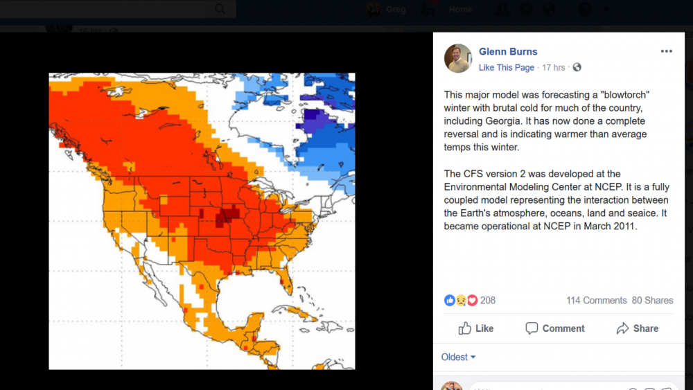
So, Glenn Burns throws this on Facebook last night. He can't even get his description right (Calls colder temps a "blowtorch") and doesn't give any explanation that this isn't an official forecast. I thought @Lookout would appreciate this.
-
Any chance the forecasted "stall" could take place off shore?
-
1
-
-
That has severe weather written all over it.
-
1
-
-
4 minutes ago, griteater said:
Look how different the pattern in the 2nd half of Jan has been in comparison to the image above
I knew it hadn't been great but given that look, it could have been worse. Wow.
-
7 minutes ago, nchighcountrywx said:
Michael Ventrice (@MJVentrice)
Models are beginning to hint of Greenland blocking towards the end of January into early February. Could partially aid in the development of another exciting winter pattern for the US and Europe if it sticks pic.twitter.com/QFZmFzIbeh
I used to watch JB vids and read his summaries when he was with AccuWeather. If I recall, he always "theorized" that during La Nina's that -NAO's became more likely toward the end of winter into spring.
-
7 minutes ago, packbacker said:
And I thought yesterdays models runs were warm...could be worse.
That damn Canadian ridge!

-
12 minutes ago, packbacker said:
Hope...these have been good in the past
Would love where the "battle zones" are located on that map!
-
1
-
-
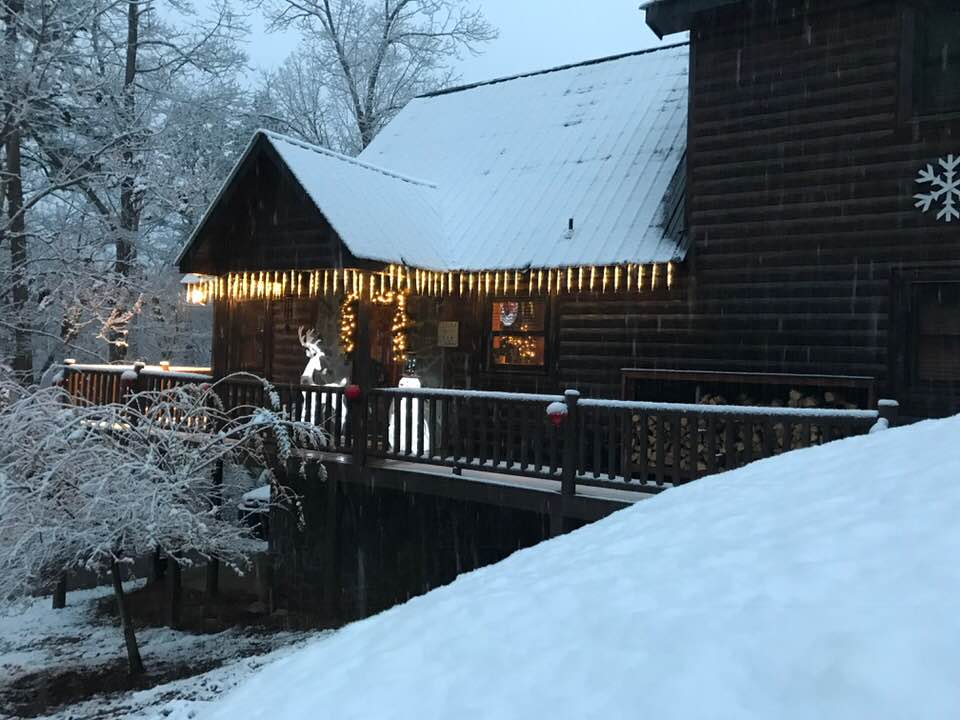
Our cabin in Ellijay this morning. Still coming down steadily.
-
6
-
-
Snowing in Elllijay, GA. Just started.
-
1 minute ago, WXinCanton said:
Yes it does! Emerson looks good too, crazy to go from being fringed to stop going North! Hope all is well.
Two days ago, Gilmer County was going to be dry so these are good developments. You and Emerson are really in great spots according to most of the models this evening. L:et's reel this thing in.
-
Just now, EmersonGA said:
I don't know about you but I've been waiting on the I-20 rule to catch up and push this thing our way.
Hey there, Emerson! It wasn't happening too fast so I wasn't sure if this thing would ever trend (expand) NW. I was assuming all points south of me would do better. We may be in the game now buddy.
-
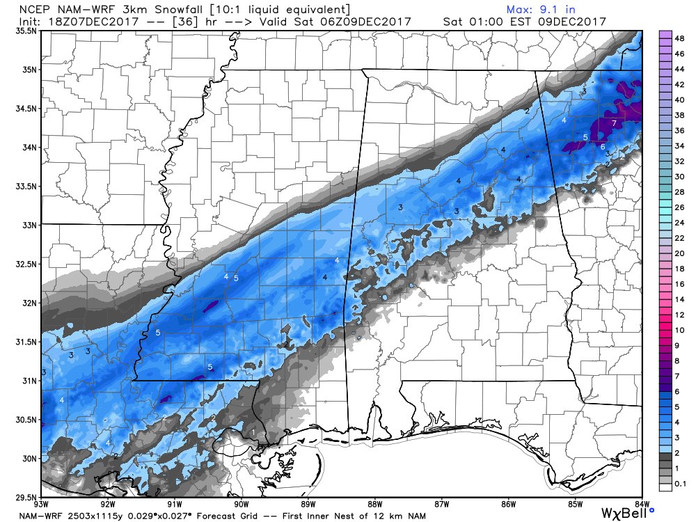
Hey, @WXinCanton, check this out my friend. I have been in Ellijay for a year now. This looks good for our areas!
-
3
-
-
1 minute ago, odell.moton said:
When does the next maps come out
Sent from my iPhone using Tapatalk00z
-
I have been following you guys from board to board since the WWBB days and I still believe the core of Southeast posters that have hung together since those days and some of the new members that have latched on since are, by far, the best on AMWX. Glad to be a small part of a great group of people.
-
Jeremy did such a great job on this..absolutely spot on everything... and I'm happy it's been brought back and pinned. Jeremy, you are the man.

Noobies/new members, and even members who have been around awhile should read it through several times. It will save you from being warned/punished and save us mods a lot of trouble.
And kudos to michelle for bumping it.
You always liked Jeremy best!


-
Me and my "baby" at a recent Alabama/Arkansas game. My baby is 16 years old now....where does time go?!
Beautiful twins Buckeye!!

-
Patiently awaiting pics of "snowstorm" from Northern, Western (just south of I-20) close to the Alabama line but East of Tallapoosa guy!

-

Me and my two favorite girls!!! Excuse the naked barbie!!
Dixie has all the fun!!!! Travelin man!
LOL! Well, we had our kids while young so we are simply making up for lost time!
Looks like you got a little sun that day. Your face is the same color as your little girl's water wings...LOL! Hope you are doing well buddy. It's been a hot one!
-
My wife and I....


Mid to Long Range Discussion ~ 2022
in Southeastern States
Posted
Fixed that