

Crazieman
-
Posts
163 -
Joined
-
Last visited
Content Type
Profiles
Blogs
Forums
American Weather
Media Demo
Store
Gallery
Posts posted by Crazieman
-
-
Is there a discord or something everyone wandered away to? First nice looking severe event in my area in years and I come in to find it virtually dead?
-
 1
1
-
-
-
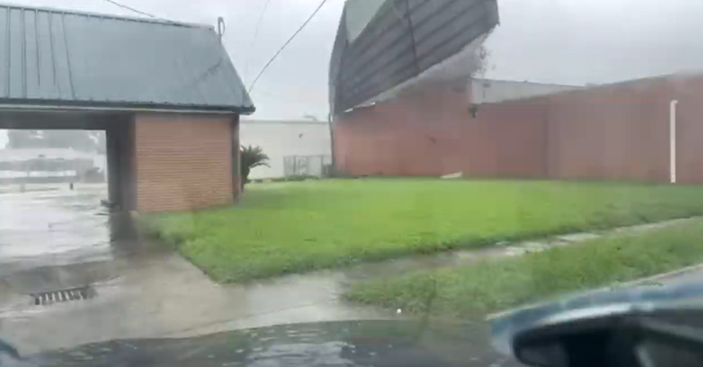
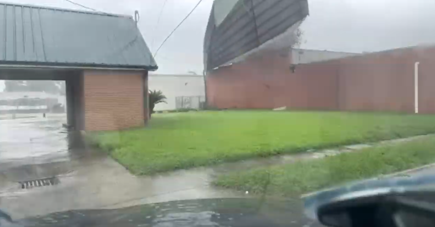
Sheet metal just struck Timmer's car.
-
1 minute ago, Bostonseminole said:
yikes roof just blew off right in front of timmer.. crazy
-
 2
2
-
2
-
-
2 minutes ago, turtlehurricane said:
Underwater cam in Grand Isle is definitely back live https://www.severestudios.com/storm-chasers/john.humphress2.html
IT LIVES!
-
4
-
-
Grand Isle camera is the blue shed moment.
This needs to be repeated for every hurricane. Make, model, and setup.
-
15
-
1
-
-
Grand Isle camera has been under some waves now. How high is it mounted?
-
Jeff is live.
-
2
-
-
Just now, DanLarsen34 said:
Next cell to go may be this one just north of Wichita.
Keeps rotating and dropping wall clouds, but never makes good on it thus far. The cloud base is very high.
-
-
37 minutes ago, KeganR said:
As I say this, we now have full cloud cover in Central OK.
Complete overcast and crapvection in southern KS
-
17 minutes ago, jojo762 said:
#HeadSouth is easily the chase target for today.
Yup, out and about already.
-
1
-
-
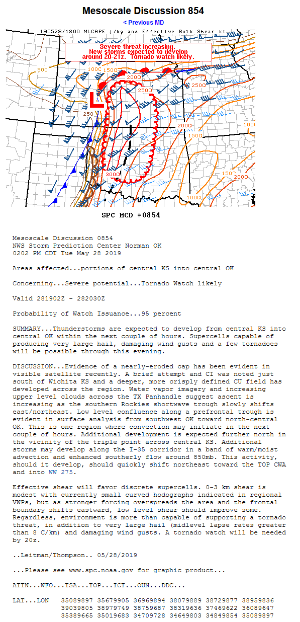
SPC calling moderate risk again, TX panhandle.
-
1
-
-
Strongly reminded of the Andover tornado with the motion.
-
1 minute ago, shaggy said:
Any scanners for the area north of joplin and points east that have had this monster wedge move through?
Dade County, MO is offline.
-
Just now, JoMo said:
Yeah, it was scary for a bit. So close.
Good God, JoMo, I remember when you disappeared after that thing in 2011.
-
Just now, SnowGoose69 said:
Yeah you can’t do that. Sometimes if you have a great view of the very bottom of the base you can gauge if it’s weak or strong based on how fast it’s rotating but I believe a few years ago there was a 1/8th mile wide EF5 in Manitoba
That was Elie, and it was pretty apparent it was a violent drillbit by the motion.
-
Cap just broke, explosive growth. (Finally)
-
Logan County has good rotation.
-
1 minute ago, StormChazer said:
Wall cloud near Cromwell,
Got a warning on it.
-
3 minutes ago, Quincy said:
The low-level shear is not very favorable in the SW portion of the watch. Seems odd, but maybe it was a CYA decision for that cell going up. Regardless, the environment becomes increasingly favorable for significant severe with northeastward extent, especially from OKC metro and points northeast.
PDS for a single cell?
Is this like maintaining High Risk on Monday for a single cell?
-
1
-
 1
1
-
-
Huh, PDS watch.
That escalated quickly.
-
Just now, iowahawkeyedave said:
Isn't this due to the "Plainfield Syndrome", where it's better to issue too many warnings and risk getting a few wrong, rather than underwarn and miss something critical?
Well, we could compare NWO's. Wichita is notorious for not issuing warnings.
-
4 minutes ago, MUWX said:
Most of the time I agree, but almost everyone was calling for a potentially historic. NWS, SPC, News outlets, Twitter mets... everyone... and it totally busted. That has impact on people, especially when in general, meteorologists aren't trusted to begin with.
We're a bit insulated in the met community to our technicals.
The dismissal of public perception and reception happens too often.

Severe Weather 4-15 and 4-16-24
in Central/Western States
Posted
In my best Maxwell Smart voice, missed it by that much.