
BlizzardWx
-
Posts
313 -
Joined
-
Last visited
Content Type
Profiles
Blogs
Forums
American Weather
Media Demo
Store
Gallery
Posts posted by BlizzardWx
-
-
Decent snowstorm over SLC last weekend. Some places were over a foot with lake effect. I had 5.4". Another 1/3" this morning.
Looks be drying out for a while with inversions and fog setting up the next few days.-
 1
1
-
-
Looking at some snow here tomorrow night and again on Sunday. I'm thinking 2-4" for me tomorrow night and 1-4" for Sunday.
-
3.3" yesterday at my house. Probably some more towards the coming weekend.
-
Very quiet here lately. Cold and dry.
-
1 hour ago, raindancewx said:

Nov Jamstec run still has a pretty big El Nino but it trended down a bit from October.

US Temperatures for DJF - the model still has the Northern Plains warm, which is what I think too. It definitely trended the SW from cool to cold, and the NE from slightly warm to slightly cool. The deep cold in Mexico is actually interesting too.

Precipitation is interesting - went much drier NW and NE, much wetter SW, especially AZ.

The Modoki forecast increased for winter. However, its a three box calculation, and if you look at the first image, it seems to be mostly from Box C (by the Philippines) coming in cooler.

The El Nino look in Spring 2019 -

I am a big fan of what this forecast shows. Nice to see it going for cold weather throughout the west and decently wet, especially SW. Most of the forecasts are for warm and dry over the interior west in my area.
-
Looks like you are going pretty warm and dry for the mountain west then. Thanks for sharing your outlook.
-
3 minutes ago, 40/70 Benchmark said:
1968, 2004 and 2014 are great MEI matches.
Years like 2014 and 1968 were pretty much exact opposites for my area. ECMWF seasonal forecast is looking much more 2014 like for my part of the country.
-
18 minutes ago, 40/70 Benchmark said:
I'm not advocating for that particular analog's utility....but I see you speak in absolutes like this quite often....."if A means anything, then B will happen"....meteorology does not work like that. Not only are there a plethora of other factors that modulate weather on a seasonal basis, but there are anomalies, as well. Sometimes you have A+B...but the atmosphere just refuses to $hit out C but atmospheric responses can simply be stochastic in nature, as well. It does not mean that a correlation/relationship doesn't exist, and you shouldn't expect C the next time.
Solar implications are very worthy of consideration, regardless of whether or not winter 1957-1958 proves a viable analog for winter 2018-2019-
His use of "A leads to B" kind of rubs me wrong for the reasons you mention here. We have to be careful in atmospheric science to not over explain things that happen to be correlated based on small sample sizes.
Don't get me wrong raindancewx, I like your posts! Just be more careful with your word choice.
-
11 hours ago, raindancewx said:
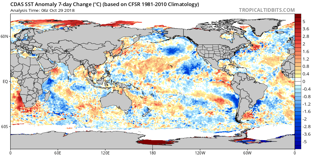
This is just speculation on my end, but I think 2002 will become vastly less similar to observed conditions this year over the coming months given how different the oceans look in late October.
If you do 2018 - 2002 for 10/26, the El Nino is warmer to the East and colder to the West. The PDO is also less positive with the incredible warmth by Japan, and the tropical Atlantic is very different. The same statements apply v. 2009 - PDO less positive, El Nino is warmer to the East and colder to the West.
The El Nino, at least for now is also much stronger than where 2014 was at this point, but less strong to the east v. 2006. The waters off the Western US are far colder v. 2014 though. The Atlantic is also vastly colder than in 2014 and 2006, with the waters by Japan, once again much warmer.
The very warm waters by Japan are reminiscent of the -PDO. They show up in 2010 for instance.
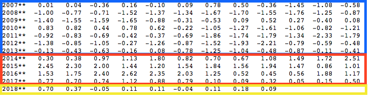
From 2007-2013 we had a pretty sustained negative PDO with only a brief positive period during the el nino of 2009/10. Then we had a positive phase for 50 months, from 2014 through March 2018. This summer its been pretty flat and oscillating near zero. Interesting that even during pretty much the entire la nina we maintained a +PDO and only now are seeing some negative months as the next el nino sets in. Hard to say if the somewhat negative PDO look is the result of a few years of la nina trying to erase the mega +PDO and will disappear as el nino builds or if there is actually something driving the -PDO in spite of the developing el nino. Any ideas?
I'd venture that 2002 looked -PDO going into winter because of the 3 year la nina event preceding it, but that look disappeared heading into winter as el nino grew. In some sense we could be in a similar boat here and I wouldn't be shocked to see the -PDO disappear in the next 1-2 months. At least for now though, the waters off of Japan are warming and near the west coast they are cooling.
-
On 10/10/2018 at 10:44 PM, 40/70 Benchmark said:
Its mainly under region 3, not 1.2.
Fair point, mostly I was meaning that its no longer strongly Modoki, and at least for the next few weeks the lower level westerly wind anomalies should keep it that way in spite of 1+2 volatility.
-
1
-
-
12 hours ago, raindancewx said:
Here is a look at the new information from the Jamstec. It now has a strong east-central El Nino.
The El Nino would continue until next Summer if we take the Jamstec verbatim. The Modoki forecast is the same essentially, all just a bit warmer.
The new run is actually very similar to what I have for temps, I'm a bit less north on where the cold anomalies are, but that's almost identical to what I have. The precip anomalies went drier in the Midwest too, presumably because it sees some blocking now (Greenland is warmer?), but I don't think its all or most of winter. My best guess in 3 weeks of -NAO readings.
The October run for temps last year actually was very good.
Nice post. Offhand do you know which years would match the east-central focus best?
-
Another 1.20" here in the last day, making 3.30" for the month. Things will be shutting down now though, with no precipitation or very little the next 10 days. First hard freeze might be coming on Monday morning though.
-
With the recent big increase in nino 1+2 temps, this nino is no longer highly west-based, but rather looks more like a basin-wide event for now.
More anomalously warm water just under the surface in nino 1+2 than further west, but if you go deep enough the biggest anomalies are further west as well. Will be interesting to see what all makes it the surface.-
1
-
-
Ended up raining quite a bit last night with several thunderstorms. My total for October 2-5th is 2.09". A friend of mine nearby had 2.89", but the airport only managed 1.22".
Some weak lake effect rain showers were noted earlier this morning but clearing out now. It was fun to finally have some action after about 40 dry days in a row and only 2 meaningful storms before this since mid June. -
On 10/1/2018 at 11:02 PM, Chinook said:
I hope that works out alright. The NWS WPC plots show 1.0" to about 2.0" for foothill locations near the cities of Utah, in the short term. As for Colorado, we should have a chance for rain on Wednesday, Friday, Saturday, Sunday, and Monday. The models show snow in Wyoming, Montana, and western North Dakota on Monday. (ECMWF is relatively close to the GFS on this 7-day forecast)
I've had 1.01" so far in the last 3 days. Should get another 1/2" or so tonight, and some additional rain Sat night-Sun.
-
Looks pretty wet in Utah the next week. My location should finish with 1.5-3" by Saturday.
-
3 minutes ago, mayjawintastawm said:
Hope so! NWS BOU keeps talking about it but it's always 36 hrs away.
Pretty strong trough signal somewhere near the west coast days 7-10, but if it goes too far west we will see dry SW winds kick up instead of a refreshing cool down.
-
Quiet weather continues in Utah. Although we did have a day with some severe storms about 10 days ago or so. Pattern change coming up may yield more rain chances with ensemble showing a mean trough over the west coast in the extended.
-
On 9/3/2018 at 9:48 AM, raindancewx said:
                Nino1+2      Nino3        Nino34        Nino4
 Week          SST SSTA     SST SSTA     SST SSTA     SST SSTA
01AUG2018 21.2 0.1 25.3 0.0 27.1 0.1 29.1 0.4 08AUG2018 20.8-0.1 25.1-0.1 27.1 0.2 29.2 0.5 15AUG2018 20.9 0.2 25.4 0.4 27.3 0.4 29.5 0.8 22AUG2018 20.4-0.2 25.1 0.1 27.1 0.3 29.0 0.4 29AUG2018 20.3-0.3 24.9-0.1 27.0 0.2 29.1 0.4
No update from CPC yet, but June was +0.13, July was +0.17. August probably +0.2 to +0.3. So ONI likely +0.2 for JJA.
Looking forward to the ECMWF update. The drop in August the model had did occur, now we have to see if the reversal happens.

The downwelling kelvin wave will probably help the warming resume again, but will be interesting to see how much. I am less experienced than you guys on the subject, but everything I can see points to a weak event as well.
-
This summer has been terrible in SLC. Smoky, hot, and dry. I've had one thunderstorm since mid June, but might have a chance tomorrow night at least.
-
Pretty interesting GFS runs today with a moisture tap from the tropical system down there into Arizona and then again with the dying remnants of another system hitting the same area. Could be quite wet in some locations that traditionally get almost no rain in June.
-
Anybody have any general thoughts for west-central Texas (Abilene) for around June 3-9? I'll be there then and would love to see some fun stuff and possibly do some chasing if its close.
-
ahh must be late? Know they hit SV in the afternoon or early evening but usually don't see them on wxbell that quick. At least the daily stamps of it.
Possible, I just know they were out for me yesterday so maybe you need to clear your cache or something.
-
Yeah, I think things still look more favorable than not. If I could go back and redo I'd probably not have shifted into June and done the usual last two weeks of May but not sure there will be a huge difference in the end. This coming week overall looks fairly favorable, main limiter may be how much moisture can get north following the weekend event.
Dailies on the Euro weeklies that came out this morning on wxbell look overall good.. higher heights everywhere going forward eventually but no shutdown look or anything.
Looks like we may leave a day early -- next Thur v next Fri -- to make sure we catch the next weekend trough in full assuming it happens... in case there's a break after. We've been spoiled in recent years having almost no down time.
The weeklies on wxbell come out Mon and Thurs for the record. Good luck with your chase though!
Mountain West Discussion
in Central/Western States
Posted
Next storm will likely be Wednesday here. Not looking huge but a few inches are possible.