
BlizzardWx
-
Posts
313 -
Joined
-
Last visited
Content Type
Profiles
Blogs
Forums
American Weather
Media Demo
Store
Gallery
Posts posted by BlizzardWx
-
-
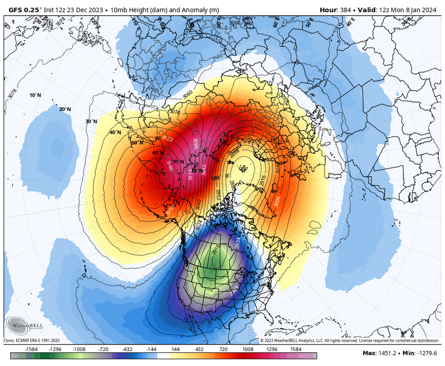
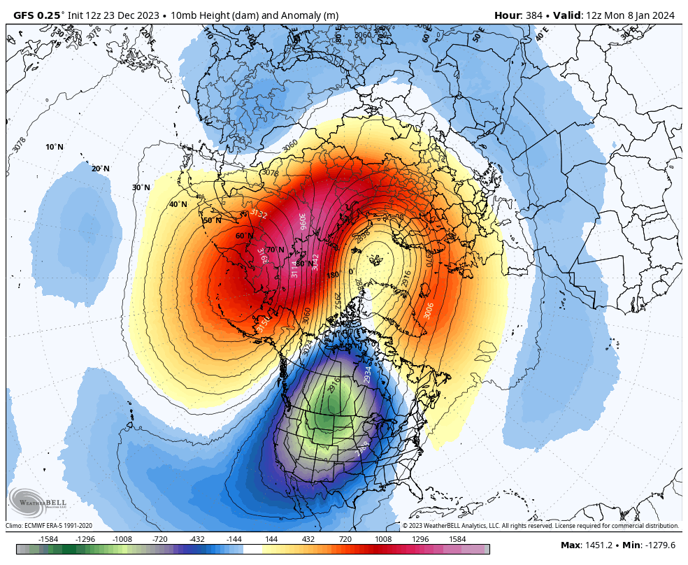
First time I've seen the a PV lobe modeled to sit over NA so far. This extends down to 50 hPa as well.
-
 4
4
-
-
36 minutes ago, GaWx said:
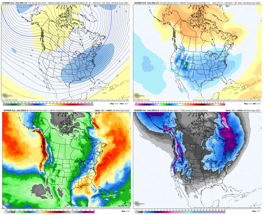
New Euro Weekly 10 mb mean wind: though likely not quite as many there are still lots of members with a major SSW in early Jan, especially Jan 3-9. Also, for the full run, the # of extreme SSWs (sub -15) increased back up to ~15:

We lost a lot of the strong +u members though for the period in question. Definite consolidation run towards the mean.
-
2
-
-
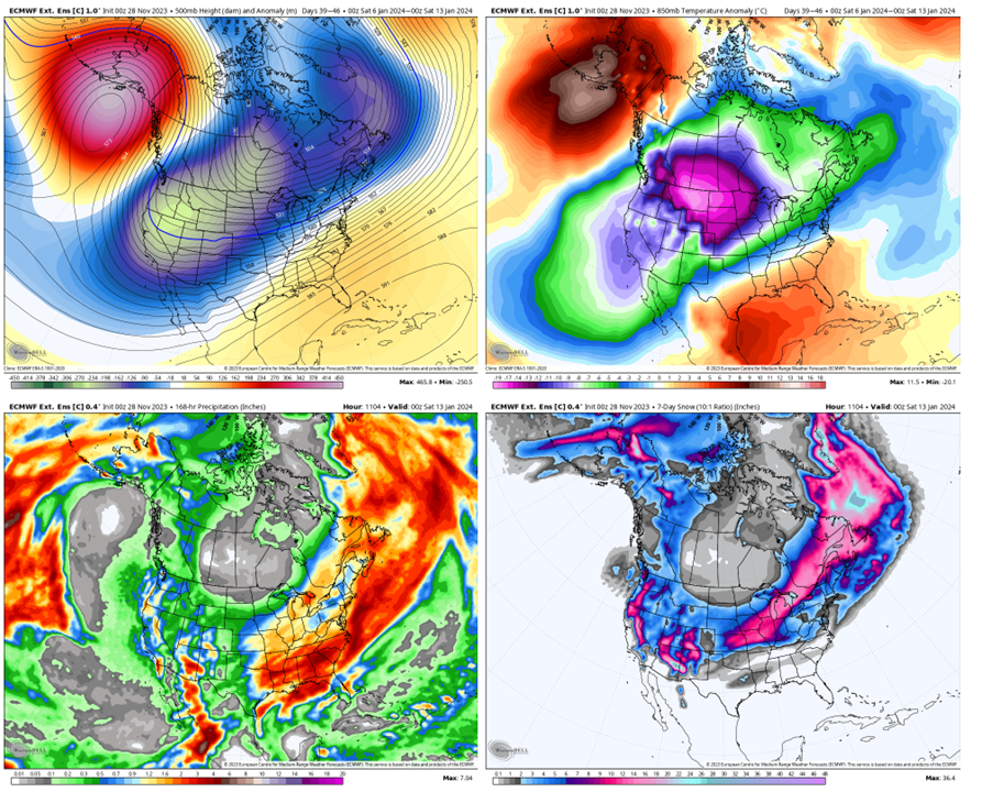
Is there any work with respect to the location of the initial 10 hPa warming in a SSW and where the cold anomalies eventually settle? It seems as of now the warmest anomalies will focus over east Asia and North America with the remnant of the PV over Europe.
-
2
-
-
MEI will likely get a good bump from this pattern going forward, but hard to say how much over a two month average.
-
2
-
-
51 minutes ago, 40/70 Benchmark said:
I honestly feel as though my primary concern is busting too positive on the seasonal NAO.
If you were issuing now, what would you change?
-
Certainly interesting on the ECMWF weekly run this morning. The control run would probably result in more snow or ice for me.
-
2
-
-
14 minutes ago, 40/70 Benchmark said:
I think 2014 is a decent match to this past fall, too.
1965, 1968 and 1987 look best moving forward.
Actually now that you say that I can see it. If you move 2014 east just a bit it matches up relatively ok.
-
1
-
-
Here is a comparison of the height anomalies for the fall so far, obviously it won't change that much over the next couple days as we round out November. I forgot to normalize the scales as a full disclosure, but it wouldn't have made that much difference in the plotted colors. Anyway, pretty interesting how persistent and widespread ridging has been compared to other El Ninos. There has been a notable lack of a STJ for most of the fall as well as incredibly broad ridging extending from the Great Basin through much of Canada. No other year matches well, though if you skewed the anomalies more positive I suppose 1997 could sort of work.
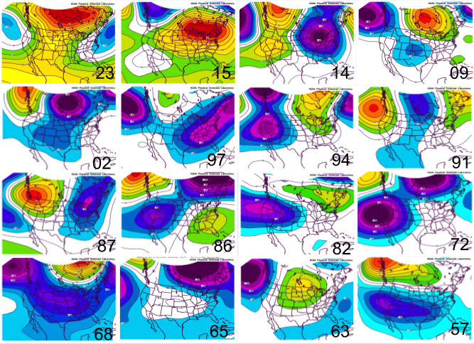
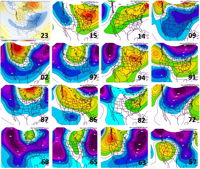
Below is the next month on the EPS weeklies versus the other El Nino years I included. Interesting to see that the +PNA/-NAO pattern showed up in only a few others cases. I thought the best matches were 2002 and 1963, with 2009 not being a bad match either. You could make an argument for a few other years, but they don't have the ridge axis in the right place which I view as essential. I suppose all this is to say, I like what I am seeing at this point.
-
2
-
 5
5
-
-
6 hours ago, bluewave said:
So we get a battle between the Nino-like +PNA -EPO and Niña-like Southeast ridge around Thanksgiving.

This is a good set up for my area. Might see our first snow or ice in this pattern if it works out right.
-
1
-
-
7 hours ago, bluewave said:
These monthly averages haven’t verified very well in recent years. None of the seasonal or monthly forecasts last winter got the depth of the Western trough correct. They were just forecasting a vanilla La Niña pattern. Instead we got the 2nd warmest winter on record in the Northeast at close to +5. None of the models were showing that kind of warmth. I think the meteorological community on twitter oversells the value of these seasonal models when many times they are just another version of the fabled GFS 384 hr snowstorm.
I mean you aren't wrong, but I'd still maintain its a different problem. For the same reason that our struggle to predict the weather in 2 weeks is basically irrelevant to forecasting long term climate change. In one you are trying to nail down the exact state of the atmosphere and the other you are trying to forecast the average state of it and smooth out the noise.
-
1
-
-
1 hour ago, bluewave said:
Why do you take these 3 month runs seriously when the EPS can hardly get the pattern correct beyond 6-10 days? Same for all the other models. Remember the Euro October forecast for the Nino 3.4 issued in September of +2.0 and we verified closer to +1.66. The one common denominator to all these winter model forecasts since 15-16 has been a cold bias in the East. I pointed out 18-19 since it that was the last time we had an El Niño pattern being forecast.
I'd say that's not a fair comparison. Monthly averages factoring in peak ENSO forcing are more likely to verify than snapshot forecasts 2-3 weeks out in many cases. But as others noted, 18/19 was much weaker and therefore you would assume the predictability would be lower too.
-
3
-
-
Is there any historical dataset of NAO/AO (etc) that has a sub monthly resolution? If you know of one, please pass it along. Thanks.
-
1
-
-
1 hour ago, griteater said:
What I would suggest is that you first search for a list of top snowstorms in Tulsa. Once you have those dates, you can go to this reanalysis site and view the 500mb and Surface maps together on one screen (you just have to select your dates from the dropdown at the top) - NCEP/NCAR v1 Reanalysis / North America (meteocentre.com)
Once you do that, you will get a feel for the types of setups where Tulsa gets hit. I would think an El Nino type split flow would be good there with low pressure tracking from Southern California into Texas, with cold air to the north. Also, big -EPO setups where cold air is diving down just east of the Rockies, and there is a weak wave running the boundary - probably lighter events, but very cold at times
Thanks, I will take a look! Also, excellent work on your outlook.
-
1
-
-
I've been reading all the back and forth for the last few months trying to improve my knowledge on seasonal forecasting matters. Thank you for all the great work everyone!
I moved to the Tulsa area about a year ago. I'd been in the west before that my whole life. My question is, do any of you have any thoughts on how the ideal combination of indices for winter weather varies between here and the east coast? It seems obvious to me that there is a lot of overlap, but that my best snow patterns aren't going to be the same ones where the northeast scores big. Anyway, let me know if you have any thoughts. Thanks
-
Finally a few dry days, its been crazy wet for a while. March 1-April 16 at my place had 8.48" of precipitation.
For the winter I had 76.3" of snow.-
1
-
-
I'm up to 57" for the winter. Should see 2-5" on Friday night.
-
2
-
-
Might get an inch here through Wednesday, better bet of several inches on Friday morning with a pretty solid system. I've had 23" for the year so far, but no storms larger than 4".
-
It would be ideal if the FV3 were better than the GFS at this stage, but at least the FV3 should have a higher ceiling than the GFS given its new capabilities. We will see!
For my neck of the woods the FV3 produces out of control lake effect when none occurs. Its kind of a pain. -
On 1/5/2019 at 1:04 PM, finnster said:
Hey good to hear that hope you get some good snow. I also hope the CO mountains get in on some snow. As far as the front range we’re likely to just get windstorms out of it. I just watered the plants in my yard today for the second time this season, and probably will have to again in a couple of weeks. Anything else I put in will be cactus and rocks ;-)
Hope it works out for you soon too. Everything is melting away it looks like with no prospects for anything other than maybe a stray inch here or there coming up. You guys need it worse than I do though.
-
Models trending up for the storm on Sunday for me. Looks like 2-4" at my house now. Another storm Monday but I will miss it at AMS.
-
We had a few small storms in SLC last week. Added up alright but most of it blew away in the downslope winds a few days back. Looks like 1-2" on Sunday.
-
It's really looking snowy here from Saturday-Wednesday or so. ECMWF with a 10-1 ratio had 10" at KSLC, and the ratio will probably be higher than that given the cold temperatures aloft.
-
3 hours ago, Roger Smith said:
Extensive damage from a tornado that touched down briefly at Port Orchard, WA around 2145z on Tuesday 18th. Video shown on local news and substantial damage to homes and trees would suggest possibly EF-2 intensity. A very rare occurrence in a less than obvious severe storm environment with a rather average sort of Pacific frontal wave coming ashore. Radar got briefly intense, seems to have dropped out of a low cloud base and relatively low-topped cb cloud. Probably the second most intense tornado in the region (think there was something back around 1972 near Vancouver WA that was rated EF-3). More damage than seen at Manzanita OR last autumn IIRC.
From what I've seen its a solid EF2 tornado, but otherwise its just as you said. In the western valleys of Oregon and Washington WSW to SW flow always has to be watched in the post frontal environment. Frequently these long and narrow bands set up downwind of the coast range from convergence with decent wind shear (southerly up the valley and SW above the valley). Periodically they spin up a weak tornado, and rarely a more significant one.
-
1
-
-
A snowy period may set up here near the 23-30th or so. Should be a few systems that will move through. Hopefully at least one turns out to be significant.

El Nino 2023-2024
in Weather Forecasting and Discussion
Posted
What are you thinking favors that? Although I am slightly west of the Mississippi so maybe that's fine too