

Hoar_Frost
-
Posts
489 -
Joined
-
Last visited
Content Type
Profiles
Blogs
Forums
American Weather
Media Demo
Store
Gallery
Posts posted by Hoar_Frost
-
-
Though the amount of snow that's likely to fall in Illinois and Wisconsin, and possibly Indiana and Michigan, appears that it will be reduced compared to what guidance suggested yesterday, I think trying to do "verification" on a feature 48 to 72 hours before it has even happened seems a bit misplaced. I think some of this commentary would be more valid if, come Friday evening, only a couple of inches of snow, in fact, fell.
Since I'll be up in the Fox Valley, I am hoping for a lot of snow, so the recent model trends are just as disappointing to me as they are to many of the rest of you. Just to be clear...-
 6
6
-
 2
2
-
-
Even a couple of inches of snow with such high winds during a high-impact holiday travel period in a city that is home to one of the busiest airports in the country will cause many problems. If one of the snowier solutions plays out, that'll just exacerbate those problems. I can understand why LOT is hitting it hard early.
-
1
-
-
I'm back to living in the Midwest as of earlier this month after about 10 years away (Pennsylvania then Florida then Pennsylvania again). I live in downtown Lafayette, Indiana, and am working as a climatologist and data programmer for the Midwestern Regional Climate Center at Purdue University.
We had some wind gusts to 40 mph and a good 75 minutes of moderate to heavy rain. There seemed to be a lot of dust suspended in the outflow ahead of it, which I found interesting considering that it rained last night.
-
4
-
-
1 minute ago, MAG5035 said:
So the majority of Bedford County gets 6-11” and 1 tenth of ice warning while Blair (Altoona) and Centre (State College) have an advisory for 3-5” and 1 tenth of ice? All while my newish grid forecast has 6-12” total. That makes zero sense lol.
My overall take on the afternoon guidance would have led me to thinking the warning swath would have looked something like this.
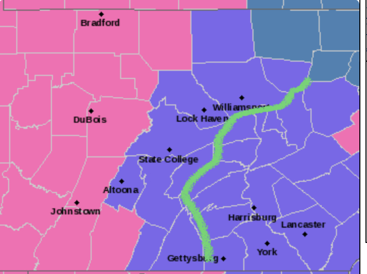
I agree. I suppose we'll see what the next shift at CTP does.
-
This is only tangentially related to the storm, but the point forecast for State College for tonight's low temperature, 5 degrees, if it verifies, would be the lowest temperature here since 2 February 2019.
-
4
-
-
7 minutes ago, MAG5035 said:
The February 2003 storm (PD2) had 18.2" measured on campus. And there was a sneaky forgotten about nor'easter Jan 6, 2002 that dumped about 13-15" in UNV. I think the Feb 5-6, 2010 storm was also about 13-15" in the UNV area as the really high totals were just south. So sounds like you guys did about as good or better than the Feb 2003 event, that's pretty good company to be in.
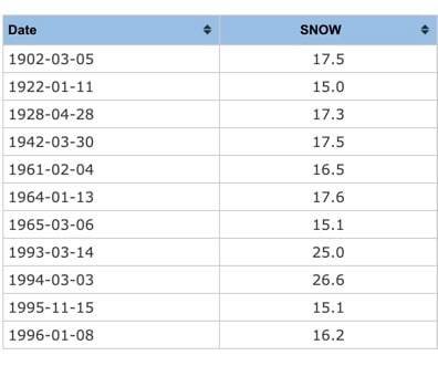
That sounds about right. As far as 24-hour totals go, today was the 12th time a 24-hour total of 15" or more was recorded at State College since records began in the 1890's and the first time that has happened in December.
-
23 minutes ago, jm1220 said:
Very nice! Much bigger than any event I saw living there 2004-2009. Was hoping you guys could crack over 20” but still, looks like the best event since maybe 1994?
I will look for sure in a bit, but it might be on par with a 2010 storm. Otherwise, probably best since '96.
-
3 minutes ago, kerplunk said:
Hmm...I'm in Toftrees near the Ale House, so not far from you. Only measured 16", but I didn't clear board, etc. Still, that's a 3 inch difference which could definitely be due to localized bands.
I cleared the board four different times. My current snow depth, which includes that kind of settling, is ~15", so that's consistent with your measurement. A friend in Woodycrest (located between you and me) had similar measurements as me. My liquid equivalent was 1.32", a 14:1 snow-liquid ratio.
Pretty legit storm for the Happy Valley, though, either way!
-
2
-
-
5 hours ago, MAG5035 said:
Wow that's impressive, are you in State College? That's a pretty big difference from State College to down here in Altoona if so. I'm between 9.5"-10". Just didn't get those rates in that timeframe with the deform banding settling just west and NW of here.
Yep, in State College, near the Wal-Mart on North Atherton. A couple of friends nearby on the north side also measured similar. I just woke up and am going outside in a few minutes to see what the balance of the storm left.
EDIT: Final measurement was 2.9" since 11:00 PM, yielding a final total of 19.1".
-
1
-
-
7.2" from 7:30 to 11:00 PM. Storm total so far: 16.3".
-
2
-
-
Snow intensity is starting to increase again here.
-
Another 7.0" of snow (since 2:30) here in the Park Forest section of State College. Storm total so far: 9.1".
-
2.1" so far (as of 2:30 PM) at my place in the Park Forest section of State College. +SN at the moment, visibility ~1/5 mile.
-
Mt. Carroll COOP station (Carroll County) made it down to -38F. So, it'll need reviewed, but the Illinois state record may have fallen.
-
2
-
Pre-Christmas (Dec 21-23rd) Winter Storm Part 2
in Lakes/Ohio Valley
Posted
Find the cold front.