

weatherlover
-
Posts
236 -
Joined
-
Last visited
Content Type
Profiles
Blogs
Forums
American Weather
Media Demo
Store
Gallery
Posts posted by weatherlover
-
-
10 minutes ago, aggiegeog said:
Upper 20s and thunder freezing rain in Lindale.
Any live storm chasers that are covering the storm right now?
-
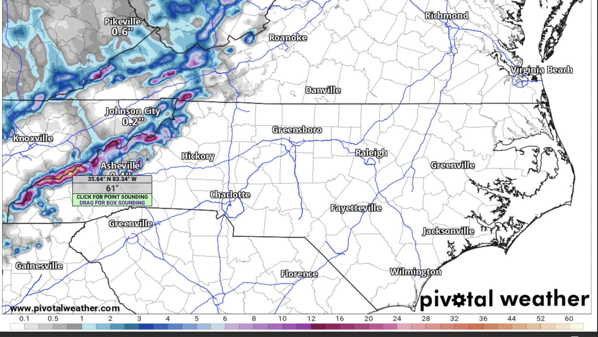
11 hours ago, nchighcountrywx said:
NAM modeling 61” snow at Clingman’s Dome!

It will forever blow my mind that us in the piedmont sit an hour away and can’t even buy a flake!
-
 1
1
-
-
Will the storm enter the gulf for a brief period?
-
Thinking about heading to Boone Saturday for the day.. are the leaves peak in that area? Thanks for any info!
-
Could be wrong but a few more ticks east and much of western Carolina’s see very little rain…. Looking like the sharp cutoff may be around Lenoir/Morganton area?
-
9 minutes ago, PantherJustin said:
Yea that’s actually becoming very interesting for Certain parts of State I just looked ….. hmmm
Which part of the state?
-
 1
1
-
-
Headed to Grandfather Mtn in the morning. Hope the leaves are near peak there! Anyone have any reports from that area?
-
1
-
-
Don’t see any reason why Fred doesn’t make a run at a weak cane before landfall..
-
11 hours ago, LakeNormanStormin said:
Only snow we saw this winter here in North Mecklenburg/Lake Norman
2/6-2/7
12-12:30 am...30 minutes of bliss
Bring on the thunderstorms Spring!

It’s sad this is what our winters have come too...
-
 2
2
-
-
10 hours ago, wncsnow said:
Will the foothills ever see a blizzard warning again? I don't think we have had one since March 93 to my recollection.
No
-
1 minute ago, TheVille said:
39/25 in statesville
What’s up with the DP rising ?
-
DP rising here also..
-
7 minutes ago, GunBlade said:
Sunset has nothing to do with the dew points. They will lower sun or not by cold dry air from the NE. Temps and dew points will lower cloud cover or not as well.
Use the link below and choose the observations tab to see current temp and dew point. That dry air to the NE is what will continue to be blown in and just how that plays out determines who gets more ice and who gets less.
https://www.spc.noaa.gov/exper/mesoanalysis/new/viewsector.php?sector=17#What you will see tomorrow is that even though precip moves in the dew point will barely move because dry air is being pumped in. Even if you are 44/25 or whatever now that will change a lot.
Thank you!
-
 2
2
-
-
Or our dewpoint stuck at where they are? Or will they continue to drop once the sunsets?
-
3 minutes ago, griteater said:
Latest Model Surface Temperatures at 6AM Thursday at Hickory (HKY) / Greensboro (GSO) / Raleigh-Durham (RDU)
Model: HKY / GSO / RDU
Euro: 33 / 30 / 33
GFS: 32 / 29 / 31
GFS Para: 33 / 29 / 31
CMC: 30 / 28 / 30
ICON: 31 / 29 / 31
HRRR: 32 / 30 / 32
3km NAM: 32 / 30 32
2.5km Canadian RDPS: 30 / 27 / 32
Yep not going to get it done around the hickory area... still sticking to my gut pretty much a 33/rain event just south of hickory to state line
-
1
-
-
Are DP’s going to continue to drop throughout the day?
-
7 minutes ago, Eastatl said:
What are the chances of this moving further south into Atlanta?
5-10%
-
Another 33-35 and rain for Western NC... Good luck to Northern NC Southern VA
-
2
-
-
2 minutes ago, PantherJustin said:
Yea, even if you slice that into 1/4th it’s .3-.5”
This will never verify south of 1-40
-
1
-
-
Just now, WXNewton said:
12z RGEM also major ice-storm looks very similar to ICON
For who?
-
Just now, PantherJustin said:
I agree, but what are we missing? Local guys all saying Rain and some talking severe ....
Probably what it will end up being. Another 33-35 and rain for most. Maybe another decent ice event towards the NC/VA line but a cold miserable rain for most
-
22 minutes ago, NCSNOW said:

Is this a reliable model?
-
42 minutes ago, Buckfever2 said:
So...it looks like Atlanta is out of the mix wintry weather ? Yes, No, MAYBE or to early to tell?
Yes
-
9 minutes ago, wncsnow said:
Honestly this should be getting more attention. Definitely could be flooding issues with this amount of rain
.thumb.png.e033537eb458278ca13faee269cab4dd.png)
I’ve been thinking the same thing. Going to be a hard pill to swallow if we day after day of rain and artic air lurking just to our west...
-
1
-
.png.8e010ee3da5fbe5fb657ded1e9581fa9.png)
Texas/Oklahoma Discussion & Obs Thread 2022
in Central/Western States
Posted
Dallas looks to be getting hammered right now also…