

Mitchel Volk
-
Posts
656 -
Joined
-
Last visited
Content Type
Profiles
Blogs
Forums
American Weather
Media Demo
Store
Gallery
Posts posted by Mitchel Volk
-
-
This winter reminds of of 1973. Cold then rrain tnen cold then rain. That winter NYC only has an inch.
-
 2
2
-
-
2 minutes ago, SnowGoose69 said:
Yeah the sleet makes sense but the rain is really odd. I guess for a short time here the BL might be near 1500-2000ft deep but odds are everyone north of a SI-New Brunswick line is going to flip to all sleet or snow/sleet when heavier echoes move in
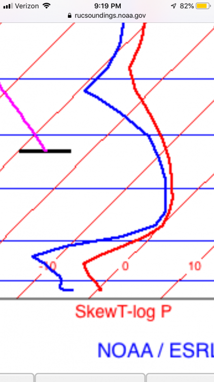
Looks like a snow sounding, I guess it is wrong, with surface wet bulb temps supporting snow there must be a decent warm layor out there. Just look at the correlation coefficent in Radar Scope and you see the rain snow line about 40 miles north of th city.
-
rain in brooklyn heights. Those HRRR projected soundings wrong.
-
1
-
-
This reminds of the winter of 1973. However, this is about to change. Still, light sleet at beaver street, about 2" at Battery Park.
-
same at Beaver very small snow flakes and sleet
-
Use Radar Scope, it the best radar out there
-
1
-
-
rain sleet snow now
-
Moderate rain in Cobble looks like it is snowing above 500 feet
-
rain in Cobble Hill Brooklyn
-
I saw that the verification score is for the whole world. I believe for our neck of the woods in winter the models is not ready yet. I hope they can improve this before it goes operational.
-
1
-
-
I have been comparing the two models and my current assessment is the GFS has been a lot more consistent than the FV3 Model. The FV3 seems to be too strong on many runs for east coast storms. Just look at the upcoming storm for the 19-20th. At one point NYC was going to get37" of snow and the latest 6Z run has mainly rain. I love to see what other people think about this.
-
1
-
-
Just look at Dec 1989
-
1
-
 1
1
-
-
3 minutes ago, NJwx85 said:
Yes but it had most areas over to rain by now. It’s still 25 degrees here. Highly doubt I get to 34 by 10:00 like the forecast says.
not at 850mb leve it was -.05 throw out there temp forecast and use your knowedge. Models must be adjusted
-
GFS had snow, if you adjusted there surface temps as they have a warm bias. The 850MB temps showed it.
-
Moderate here at Beaver St
-
Nearly moderate here at Beaver St lower Manhattan
-
Snow fall rate pick up rapidly here at Beaver St Lower Manhattan
-
First flake here at Beaver St lower Manhattan

February 2019 General Discussion and Observation Thread
in New York City Metro
Posted
1973 no days of snow cover