
N. OF PIKE
-
Posts
11,197 -
Joined
-
Last visited
Content Type
Profiles
Blogs
Forums
American Weather
Media Demo
Store
Gallery
Posts posted by N. OF PIKE
-
-
I'd feel pretty good on the south shore right now...they will avoid any screwzones I think.
Yup, Scooter can sit back count his snow and hand out his "you'll be fine" posts to others sucking subsidence exhaust ( I know Scott likes to keep those from melting lol) but as I posted earlier, it is easy to make that post when you are in particular not failing to meet your area's forecast amounts (whether it is zero or 20).
-
Ginxy
Did this link for 850 wind anomalies add another color for this storm , lol http://eyewall.met.psu.edu/rich/NAM/
Haven't seen 6 SD on there before?
-
Only piece of guidance that far west.. I'm glad it's the nam lol. What trash
These posts seem fine in a quiet pattern lol, but you realize the WPC was heavily weighting them in their forecasts, starting yesterday
-
OES is a wild card today. You can see it esp in Essex county now.
Hi Res Nam I thought hit the timing of this initial stuff very well. Had S Shore getting it 14-15z so not bad
Scott you gotta be excited out of your mind. I mean you are going to do Very well.
Scott one thing nobody has talked much about (except Ginxy) is those INSANE 850 Wind anomalies....is this going to really enhance snowfall along the coast , or not so much
-
If it played out and I got 14 and I'm flanked by 30 inch amounts, that's a fair melt imo
You know what it comes down to, Someone that is NOT in your location sees things from Their perspective and not yours and acts like their perspective should be yours.
We see it when Powderfreak simply comments that he thinks there will be a significant drop off in N VT (compared to the rest of us) (in other storms) and coastal says to him "you'll be fine". From Scott's perspective if he's raining and PF sees 7" (regardless if 50 miles SE sees 18" he's fine. That perspective can border on pointless from powder freak's shoes even thou you can sort of bend your mind around and see it and usually be like "ok" I get it.
So I think you make a very fair point that if you are flanked by 30 inch amounts and you have 14, you can certainly melt.
There is thou the added perspective in this storm that nobody (including you) was getting jack 4 days ago, and that should be weighed into YOUR current perspective and give you a option for a positive spin on this storm almost regardless of what happens. Some people weigh this more but usually there is a mix of the two, I think anyone would be lying if they got 15" and they were watching radar in the storm and areas on each side (say about 25 miles ) had double but most don't voice it that much because, especially in a situ like this , remember you had nada forecast 14 days ago and well most people like to think positive in life.
-
I tried to post this yesterday, but I don't remember if it went through with all the board issues.
For posterity:
If I stop to actually think about it, I really thought we were beyond a point where models would not be able to see a KU Blizzard 4 days out , or at least the Chance of one, I don't know the model history of this becauses I honestly didn't start paying attention until Saturday 12z runs. This is now billed as a Historic storm and models didn't see it at 96 hours, which to me is so unbelievably rare in this day and age I wish we had a discussion (perhaps we did) as to why this was in the models "blind" spot up toward 96 hours.
-
Weenie Meso Model BTV WRF 4km shifted east from earlier
NIce Banding Signal of course
-
Id take my chances with Worcester
HFD not a safe bet. Go to ORH
-
NYC folks just had heart issues and at the last moment they were saved on Euro. Now they will do it again at 1pm.
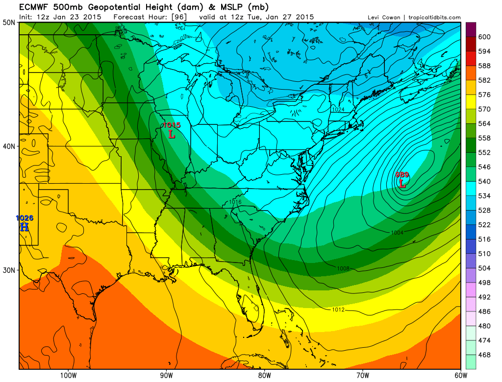
Oh and look at this thing
-
Time to change the sig
"Who will be the first to derobe....
hahahha you are Right sir
Rev is snoring "tickle Tickle"
-
Was supposed to drive over there from Ohio to view this thing. Starting to wonder if it's a good thing I didnt. The GFS last night concerned me even with the error it had. But these east shifts are making me glad I didn't travel that way yet. Was gonna leave at 6am. Maybe the euro will leave hope but as difficult as this forecast is becoming it may be too much risk to drive 10hrs. Still will be significant but not like 13' if these shifts keep happening. Good luck to you all though. I know I had a blast chasing the one in 2013 just not sure if this one will be worth the 10 hour trip. Hope it comes to fruition for you all.
Over where ? SNE this thing is not going OTS, When Harvey Leonard says "lock for top 10 snow storm" you make the trip ORH or BOS
-
Key with Euro Was the Phase Timing, it was quickest phaser and just had ML lows in areas favorable area and longer time for NYC , most expect a little bit later phase
-
Ukie was fine for most...a little worrisome for western folks, but you know the deal with the western fringe of the heavy QPF in these types of systems

BOOM YA!
-
It actually tucks in west of 18z.
Yup but the path it takes to is wider right
-
Probably tougher to be an Upton met
-
if we can get deform band over ORH with the Upslope of that deep easterly flow as well.....
-
No love for me?
haha I edited my answer BEFORE seeing your response right now. You are directly under that CMC jackpot (not that it matters too much)
-
Lock it up!
Is Ginxy in that jackpot?
we used to have a poster in Woodstock Ct that is directly under that , and good ole Ice Warrior Commander where ever he and his (Rapid arm movements) are now.
But others are very close as well.
-
Ray is actually in Deform band on new CMC right down to good ole ORH as Kev hangs on by his weenie to Western Edge of it
-
I have Bufkit
What say you for Boston, Mr. Magoo
Also Ginxy, how you think things will be lookin in Scituate around 4-5am Tues near the beach, MAN!
-
Problem is there wasn't a similar evolution last winter at all. Yea this may bump east a tad on the Euro but watching spiral bands, dude cmon
The post below is from NYC met , so remember he is referencing his area
A double barrel low is certainly possible... keep in mind the solutions both the NAM and RGEM are projecting were within the realm of possibilities provided by the ECMWF EPS.
This is more than a convective feedback issue... I've been looking at the initial conditions of the current clipper and it looks like its been moving a little faster than expected. For the best possible phase, we don't want to be moving as quickly so the next shortwave can capture it further west and hence allow for surface cyclogenesis to occur further west. The trends aren't good because it looks like the last 12-18 hour forecasts was a bit too slow with the primary shortwave.
-
We should start a Guess the lolli town thread and maybe you get like 1 guess and you can edit it up until 2pm tomorrow!
-
Word on street is that NAM initialized wrong
I would toss it, but It absolutely brutalizes NE mass so we chuck em
-
Stumbled upon this last night...what a great 1-2 punch that was:
nice nite for Scott to jump off Tobin.
i prob would have had like 7-8 in Melrose/Wakefiled while areas 2 miles west got near a foot, but i could deal
Forecast/storm discussions and part II Manitoba Mauler
in New England
Posted
Just make sure you are awake in the wee hours into Morning rush to see that Fronto Band absolutely demolish you