

N. OF PIKE
-
Posts
11,197 -
Joined
-
Last visited
Content Type
Profiles
Blogs
Forums
American Weather
Media Demo
Store
Gallery
Posts posted by N. OF PIKE
-
-
looks like PYM county enhancement on radar right up to a few sprinkles of green returns near jay in s bos
-
radar juicing up over West Central Long island and NYC and backing up West more noticeably to the south of Long island. Not that it means anything for here, just a observation to the SW
the thing that is slightly interesting is the vortex (on radar) just east of NJ , maybe a radar trick http://radar.weather.gov/ridge/radar.php?product=N0R&rid=okx&loop=yes
doesn't show up as well on mt holly so I highly doubt it would be any sort of LP
-
oh mann, Bliz can't you stay up just one nite!
-
CF not that sharp but west we see low 20's / East upper 20's (from Boston to Salisbury) .
Seems to run Newbury-Middleton-Melrose-Belmont but not that sharp wrt the N shore
-
Scott you still at work, are you looking at things closely
What do you think about mid level low development and timing regarding models or what you see or No real difference
-
MVY under the freakin gun right now . Look at that beast of a band
-
NYC is getting pretty lucky with that narrow band of snow. That may save them if some of the eastern solutions are correct. It looks like just north and south of the city hasn't gotten much of anything though.
That is accurate
but I would argue that it was modeled pretty well as a meso feature like that could be on 0z and 12z hi res nam....and it just sort of slowly expands until and they pound till like midnite and then the deform develops on top of them from like 1am to 8am ....which is obviously up in the air.
-
No model had that band in LI.
pretty damn close
0z hi res nam
http://mp1.met.psu.edu/~fxg1/NAMSFC4_0z/rad23.html
12z hi res nam
http://mp1.met.psu.edu/~fxg1/NAMSFC4_12z/rad10.html
in fact the 18z hi res nam absolutely Destorys NYC then NE NJ Lower H.V between like 8pm and midnite while we wait for the frontogenesis to start to work up form cape around 11pm-Midnite
-
I love the east vs. west....north vs south...NE vs. SW...etc battles that go on in here during these storms while jockeying for jackpots and hardest impacts.
deep down in your inner weenie mind you dream of the Euro's 1" QPF verifying....what would that be 18-20" with ratio's in that deform
-
mid levels aren't anywhere near closing off yet western peeps.
Jay, do you SPC page for that. Also do you have an idea when the euro closed off 7H and 5H on it's 12z run....this is data I have been trying to find and can't. This is what I would like to watch
-
Heavy snow now.
James are you close to route 6 or closer to the ocean. I.E what part of Harwich you at
-
I would LOVE if a Met or knowledgeable hobbyist could help me/ others with something
http://www.ssd.noaa.gov/goes/east/nwatl/flash-wv.html This is the water vapor loop......IT's apparently about the timing of the capture/closing off mid levels (which is different on models which results in their uncertainty) Now can anyone Use a current image of this loop and draw or point out what features we are looking at on WV to actually phase and where one should look on WV loop . It may be amateurish question but I would like to know and If I mis-stated what to look for please correct me.
Would This be a good place to look, scroll to "Basic UA" then click on the 500MB analysis drop down and watch to see where/when that fully closes off. If I recall the euro started to close off 5H but waited longer on 12z run
-
I was on the Cape for the blizzard of 2005. Watched the Boston stations the NIGHT of the storm as snow was falling and they were still calling for 8-16 with a changeover to rain. We ended up with 36 inches...Nothing is set in stone IMO and I truly believe the Cape is the hardest location in the United States for snowfall forecasts. This storm could be anywhere from 12-26 inches tonight and I truly believe its a 50/50 call.
Oh def. forecasting nightmare sometimes
What town you posting from on the cape!?
-
GFS was already wrong for NYC. NYC reporting 4.5" as of 5:00
they got that freak Thin Meso Band....that went out to N shore of L.I
I think 5 miles south of NYC has a dusting lol
-
Box is going to be way off with Cape Cod accumulations.
How so?
they have 14 to 18 on W part of cape then 10-14 down the spine of cape thru N Harwich (Along route 6) to almost CHH, seems like they tried to put as much detail into that as they could
We are all pulling for you James.
-
BOX's
-That map is Unreadable- REV
-
GFS qpf totals will bring frowns to lots of faces. Still a decent storm.
Ride the EC.
snowing lightly at the Pit.
16.4/6
The GFS is an embarrassment of a model.
Euro is king . we know this
-
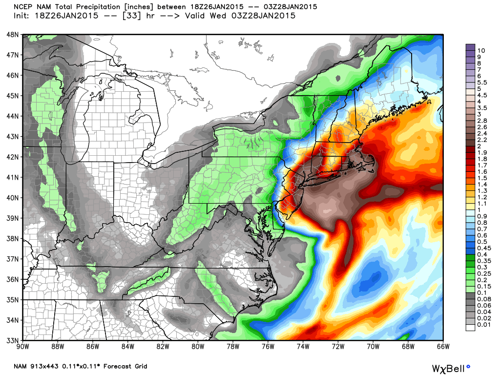
18z NAM QPF... two large metro areas just destroyed. A Tolland County nightmare. The NYC battle is amazing... EURO and NAM going big, a lot of other models going quite low.
LOL nice subsidence zone
-
Well the NAM looks like the EURO as far as banding goes.
Yup this thing is very interesting.
Nam/Euro is not successfully bet against often but I mean we shall see
It all comes down to when the Full Capture and closing off of ML lows occur, track is pretty much same on all models give or take
-
The CF looks ridiculous for the Boston area on the euro.
I was wondering about that!
That Is a key ingredient for obscene totals in Boston .....
I was trying to load my fav meso model for CF stuff but the 4KM BTV WRF at 12z won't load for me
Dick Albert (remember him old weenies) is Chuckin em' on Harvey's Twitter
"This storm could be top 5 in Boston.
In addition more snow later in week.
In addition, some of coldest weather in years in early February."
-
Urgent , i can switch my reservation mansfield instead would that be better?
I'd say so, I mean you can't KNOW FOR SURE....but Mansfield looks golden.
I mean euro gives Mansfield 42-48 lol
-
This is a now cast.
I can see clinch hedging toward a continued E tick but as this thing explodes it may surprise
Gotta SAVE these images. Just a MONSTER http://www.ssd.noaa.gov/goes/east/nwatl/flash-wv.html
-
Euro goes neg tilt faster, and closes off sooner . NYC destruction *per NYC PBP
-
When does Cory P's flight leave Ft laudy (Snowman) or did it already

Forecast/storm discussions and part II Manitoba Mauler
in New England
Posted
Clinch Your the man on this storm
I have seen you nail another storm like this
Well done man, well done