

Steven_1974
-
Posts
244 -
Joined
-
Last visited
Content Type
Profiles
Blogs
Forums
American Weather
Media Demo
Store
Gallery
Posts posted by Steven_1974
-
-
19 hours ago, WxWatcher007 said:
98L with 50% 5 day development odds now.
Tropical Weather Outlook
NWS National Hurricane Center Miami FL
800 PM EDT Thu Aug 22 2019

For the North Atlantic...Caribbean Sea and the Gulf of Mexico:

The National Hurricane Center is issuing advisories on Tropical
Depression Chantal, located several hundred miles southeast of Cape
Race, Newfoundland.

1. Satellite and surface observations show that a broad area of
low pressure has formed just northwest of Andros Island in the
central Bahamas.  This system continues to produce a large area of
disorganized showers and thunderstorms that extend eastward over
the western Atlantic for a few hundred miles.  Environmental
conditions are forecast to be conducive for additional development
during the next several days, and a tropical depression could form
over the weekend or early next week while the system moves near the
coast of east-central Florida and then offshore of the southeast
United States coast.  Regardless of development, locally heavy rains
are possible over portions of the central and northwest Bahamas, and
the east-central and southeast Florida peninsula during the next few
days.
* Formation chance through 48 hours...low...30 percent.
* Formation chance through 5 days...medium...50 percent.

Forecaster Brown/Roberts
Looks like it's up to 90% development odds over next 5 days.
-
7 hours ago, FallsLake said:
From RAH:
The heat wave is expected to break Monday into Tuesday in a big way. Heights fall giving way to a large scale cold front that will move into the region late Monday and Tuesday. The front may stall or linger into Wednesday. Moisture pooling and strong convergence should bring a good chance of thunderstorms and showers, with considerable cooling as well. Highs by Tuesday and Wednesday should hold in the 80s, possibly some 70s over the northern Piedmont Tuesday and Wednesday!Man, really hope so. Getting really sick of this heat. Really didn't like the monthly forecasts that I saw come out with talk of above normal temps for August-October.
-
3 minutes ago, ryan1234 said:
Yeah, that really surprised me. I would have assumed that there would have been at least a high risk for tornadoes and a moderate risk for EF-2's+. Even within the squall line.
Well if the risk from that is down a bit, I'll take any win I can get. Would like to avoid anything severe as much as possible.
-
 1
1
-
-
2 hours ago, downeastnc said:
Though this storm was much larger and covered GA/SC/NC its still the closest thing to something like what the GFS has in living memory....its been 35 years since something like that has happened...

35 years? Guess we're due, right?
-
2
-
 1
1
-
-
1 hour ago, WinstonSalemArlington said:
Joe BastardiVerified account @BigJoeBastardi
Classic Spring temp pattern for big tornado outbreaks, one on Sat, the other next Tuesday. Thats the bad news. Good news After March 15 cold overwhelms the east and shuts season down ( but its bad news cause it means a very cold last 2 weeks of March entire nation,IMO)
He's been pretty wrong about everything all winter.
-
 3
3
-
-
43 minutes ago, mackerel_sky said:
Can it flurry at 40 degrees!? Go figure the moisture comes hard NW and my high tomorrow is 52! Models overdoing the cold, yet again!
it did in Las Vegas at 50 degrees, so it's possible.
-
2
-
-
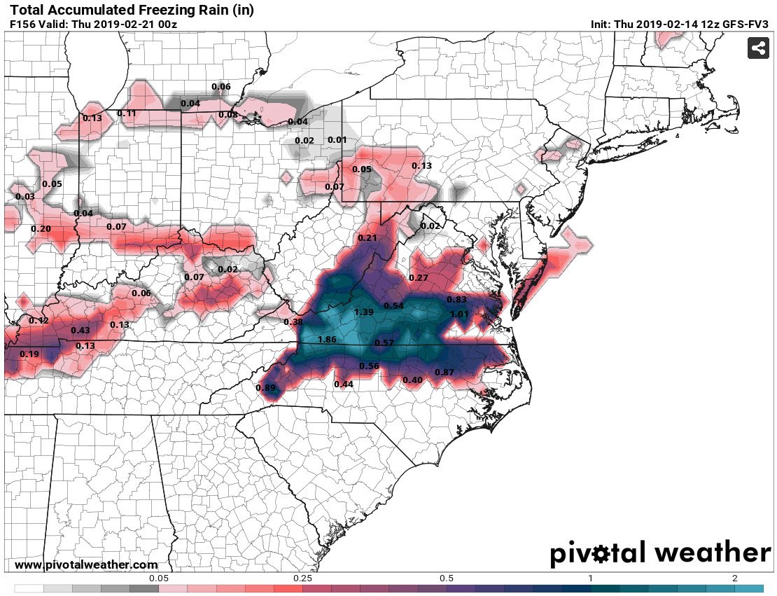
2 hours ago, FallsLake said:
The 12z FV3 did come in a little colder for next weeks potential event. Would be significant ice for our region. But, I agree it hasn't done well lately.
Freezing rain totals:

Hard pass on that one if that was our only option.
-
But I thought Bastardi said it was going to be super cold this winter for most of it and those of us in the south were going to see a lot of snow. Guess his hanging on analogs didn't work out so much for him. Way off on everything.
-
I'm fine with the map fizzling out if all it ends up is showing a massive amount of ice here which would be devastating. No one needs that.
-
1
-
-
Snowing hard in my part of Cary near Harrison. I imagine the roads are gonna get worse and tonight and in the morning will be a real mess for sure.
-
Fingers crossed to all of us to stay below the threshold of tree and power line issues with any freezing rain.
-
3
-
-
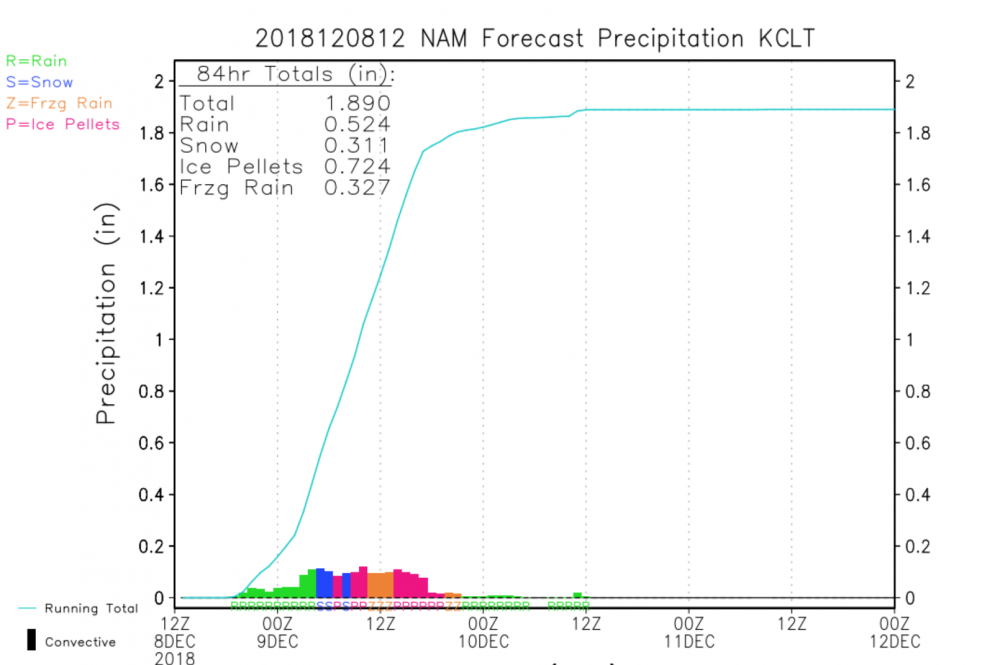
Where is it we find the graphics that show what models like the NAM puts out per location like RDU over a given timeframe? Where it shows how much is Snow, Sleet or Freezing rain. I can't seem to locate it anywhere.
Something like this is what I'm talking about:
-
12 minutes ago, packfan98 said:
Well, scratch my earlier freezing rain graphic with the 3k nam. It got icy over the last few panels.

Really hope that doesn't materialize. That would be a massive mess. Don't need any more damage across the state.
-
2 minutes ago, FallsLake said:
Actually I would consider that a win. Bring it!
Just subtract out that .25 of freezing rain and I'd take it. Banking on more snow than that though.
-
1
-
-
36 minutes ago, SnowDawg said:
Cranky weather guy from twitter mentioned this in his blog yesterday saying that the storm was late to bloom but not late to track. Basically that what was happening out west wouldn’t translate directly to the east coast and in fact he said there might be an inverse reaction where things are wetter over here than expected. But things went south over there not because of more suppression or the low forming way south, but simply because cyclogenesis was later than initially modeled.
Just FYI, Cranky Weather Guy isn't a meteorologist so take anything they say with a grain of salt. It's been pointed out on this forum before how off base they've been.
-
Hopefully somehow the freezing rain can be minimized with this system. Last thing the Carolinas needs is more tree issues.
-
2
-
-
14 minutes ago, mackerel_sky said:
Can’t complain about that look! I’ll take anything other than rain!
Hope you're including no freezing rain in the no rain statement.
-
29 minutes ago, Queencitywx said:
I really doubt this storm ends up as 100% snow for anyone except the mountains, including the foothills. The ratio of sleet to snow obviously grows as you push further east but the question is how much sleet. I do feel pretty confident right now that it's either going to be sleet or snow at this juncture IMBY. If I was s&e of 85(Cary, Raleigh, Most of Wake and Johnston), I'd be really concerned about a massive ice storm. I also feel like we're going to see a colder surface reflection with the damming and heavy precip.
If the choice is between ice storm and a cold rain here in Cary, I'll just go ahead and take the cold rain. Last thing anyone needs.
-
4
-
-
Where do you find all the panels for the various solutions these models spit out, where say it shows 20 of 40 members with snowfall in them?
-
Just now, Regan said:
My phone is going off like crazy from met people I follow on twitter. I think it’s gonna hit the fan here in Wake County soon.
NWS just put Wake under Severe Thunderstorm Warning till 6:15.
-
1
-
-
9 minutes ago, Poimen said:
Wind has really picked here the last few minutes. Some wind damage reported in WINSTON.
Where did you happen to see that?
-
Wind has really picked up near RDU Airport in the last 30 minutes or so.
-
How often would you say a wind gust would come through in an area like the Triangle in a storm like this?
-
2 minutes ago, CaryWx said:
Does anyone have a link to the latest power outage projection map for NC? Thanks
-
 1
1
-
Hurricane Dorian Banter Thread
in Tropical Headquarters
Posted
Sent from my SM-N950U using Tapatalk