

blackjack123
-
Posts
378 -
Joined
-
Last visited
Content Type
Profiles
Blogs
Forums
American Weather
Media Demo
Store
Gallery
Posts posted by blackjack123
-
-
I just woke up... this death toll is a joke right?
Unfortunately no. Very, very scary.
-
Errr, no, you cannot possibly have "EF4" damage to trees from a tornado. The EF scale doesn't allow it.
Why is that? 167mph on the upper bound falls into the very low-end of EF4.
-
Just going off things we know for sure at this moment...
Trees debarked with only stumps of largest limbs remaining is EF3 expected damage, but only can be determined up to the highest (167 mph) at that scale. After that it becomes impossible to tell with any certainty how strong the winds were.
Likewise, we know transmission towers outside of Birmingham were taken down. Again this type of damage is consistent with EF3 damage, but once total loss occurs it is impossible to tell if winds were stronger.
As for other structures we've seen, there was that McDonalds in Tuscaloosa that was rendered down to just about nothing but the guts (could even argue completely gone). This damage is consistent with EF3 (or high EF4 if you consider it a total loss), and again higher wind speeds can't be stated with any certainty because the structure is expected to be gone at high EF4.
Easily EF3+, almost definitely EF4, and I personally need some context with what certain structures were before they were reduced to rubble before declaring EF5 for sure.
I am no expert but I think tress could go up to EF4 damage. I remember seeing tree damage in Andover,KS, Moore, OK, Harper, KS, and Parkersburg Iowa where not only was the trees completely debarked but also shredded down the center. I dont think there were even stumps even remaining. I am seeing trees in Tuscaloosa that are looking comparable. This tornado was at least an EF4 and no less. It is very obvious how violent this tornado was.
-
Chad Meyers was completely hideous when they had him on briefly on Anderson Cooper at 10PM last night; he basically proclaimed the outbreak "over" because the "atmosphere was cooling."
I think roughly 20 people were killed after 10PM last night.
It goes to show you how politics and money comes before the people who lost their lives in this tornado outbreak and a number of these victims probably paid taxes to support these a**holes
-
]
You can clearly tell that this was a strong ef-4/ef-5 tornado, similar to the Moore, OK tornado, alot of the pictures were just rubble and destroyed neighborhoods from the Moore, OK storm compared to the current damage photos. I grabbed an image from the '99 destruction compared to what happened today.
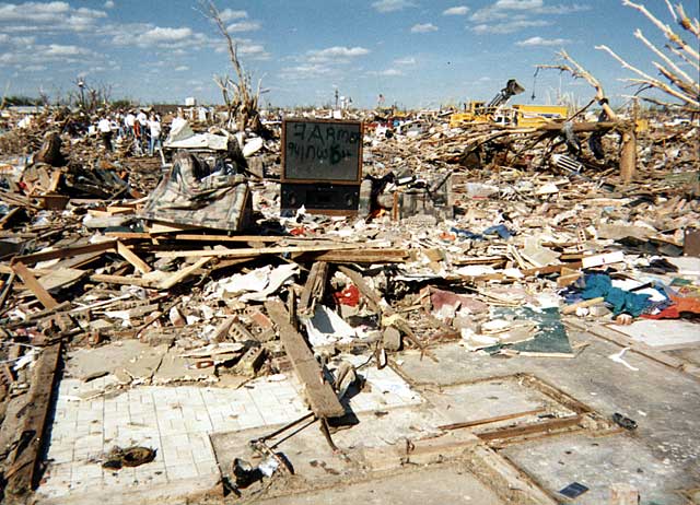
I just saw a scene on TWC where Jim Cantore was standing in the Tuscalossa area with trees totally debarked similar to the picture you have from Bridge Creek/Moore/OKC tornado in 1999. I dont know if this tornado was as strong as that one but defenitely more deadlier. At minimum this tornado was at least EF4 and most likely an EF5. Utter devastation.
-
213 deaths according to TWC.
-
The new death toll I heard was 183 and probably rising. That is just beyond unimaginable for todays technologies and advanced warning. Like others said if it was an EF3+ tornadoes striking major populated areas and winds high as 160mph+ cause structural failure to almost any type of of building. In addition I am highly suspecting a number of these tornadoes will be rated as violent EF4 or EF5 tornadoes. NWS offices, TWC, and other news coverage areas did do a great job yesterday and did save a lot of lives although there was a very large death from tornadoes. It is a very sad and sobering day to say the least.
-
Shows how pathetic news is here in the US. BBC and and other European news sites have their front page news stories about this event. Here--CNN has the Obama birth certificate/Donald Trump crap as the front page news. What a joke.
Yep it is all a big joke just like you said and I posted it in the post above this one.
-
Because its that mighty dollar and media scandals is more important to them people rather than lives taken, injuries, and property destruction from this tornado outbreak.
-
Death toll now up to 83, 61 in AL alone:
http://news.yahoo.co..._severe_weather
Note that this does NOT include the additional deaths indicated in the MS LSR's, and several unconfirmed TN fatalities. When all is set and done the death toll will likely top out above 100.
To put this in perspective, the last time a tornado outbreak killed over 100 people was 4/3/74.
It will surpass even the May 31, 1985 tornado outbreak which killed 88 people in the US and Ontario.
-
]
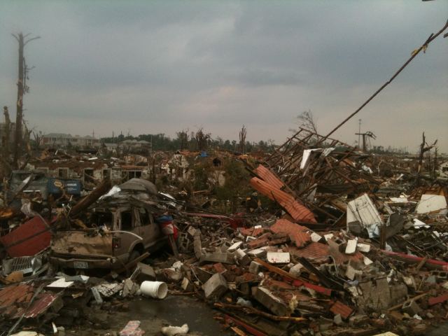
You can clearly tell that this was a strong ef-4/ef-5 tornado, similar to the Moore, OK tornado, alot of the pictures were just rubble and destroyed neighborhoods from the Moore, OK storm compared to the current damag] photos. I grabbed an image from the '99 destruction compared to what happened today.
Yeah that is really bad but I dont know if it is as the one above. The trees are completely debarked in the photo above in Moore, OK. There could very well be areas like that in Tuscaloosa although. I am sure that was probably at least an EF4 tornado and if not that it was an EF5.
-
AP: death toll now 64
This makes my stomach sick. This is just beyond horrendous.
-
This is unbelievably scary. This will be extremely historic.
-
At least 40 tornado warnings with some of them as tornado emergencies.
-
Wow
327
WFUS54 KHUN 272025
TORHUN
ALC071-089-095-272115-
/O.NEW.KHUN.TO.W.0070.110427T2025Z-110427T2115Z/

BULLETIN - EAS ACTIVATION REQUESTED
TORNADO WARNING
NATIONAL WEATHER SERVICE HUNTSVILLE AL
325 PM CDT WED APR 27 2011

THE NATIONAL WEATHER SERVICE IN HUNTSVILLE HAS ISSUED A

* TORNADO EMERGENCY FOR...
 SOUTHEASTERN MADISON COUNTY IN NORTH CENTRAL ALABAMA...
 SOUTHWESTERN JACKSON COUNTY IN NORTHEAST ALABAMA...
 NORTHERN MARSHALL COUNTY IN NORTHEAST ALABAMA...

* UNTIL 415 PM CDT

* AT 319 PM CDT...NATIONAL WEATHER SERVICE DOPPLER RADAR WAS TRACKING
 A LARGE AND EXTREMELY DANGEROUS TORNADO ABOUT NEAR ARAB...MOVING
 NORTHEAST AT 45 MPH.

* LOCATIONS NEAR THE PATH OF THIS TORNADO INCLUDE...
 HEBRON.
 COLUMBUS CITY.
 GRANT.
 WOODVILLE.
 LIM ROCK.
 LARKINSVILLE.
A number of those tornado warnings are just tornado emergencies.
-
Even if we had the same number of tornadoes and tornado strengths, and even given the population growth and sprawl that has happened since 1974, I do not think we would see the same number of fatalities, and probably not the same number of serious injuries.
The warning and detection is light years ahead of what it was then, and medical advances, better emergency first response, emergency treatment, etc. would limit the number of fatalities-some of the people who died then would have survived with faster and better treatment available today.
Also with the mass media we have today and instant communications with various devices(cell phones, computers, etc) more people would be aware of what is going on, and be able to take some kind of measures to protect themselves and get to some kind of shelter.
*The only exception to this I believe would be a worst case scenario thing, with a strong tornado striking a sporting or entertainment venue with thousands of people who are simply unable to get to appropriate shelter in time, and with a catastrophic structural failure like in a large arena, auditorium, concert hall, etc.
The damage totals could very easily be greater given urban/suburban sprawl, overall population growth, and simply more developed land to be hit
Yeah a lot of things have changed since 1974 but like you said a EF3+(150+mph winds ) hitting a sports arena or auditorium packed with tens of thousands of people without getting to shelter on time.
-
Seeing how things have initiated this morning, it's clear today's outbreak will be a far cry from the Super Outbreak of 1974...as the vast majority of posters suspected.
Still looks like it should be the most significant outbreak in quite awhile, though, especially counting yesterday/last night's tornados.
Hopefully we dont get fatalities like then. But like I said even if we even a third or a quarter of the strong/violent EF3+ tornadoes like we did in the Superoutbreak of 1974 it could be quite catastrophic. 1974 had 35 F3's, 24 F4's, and 6 F5's. Imagine getting 8-12 EF3 tornadoes, 5-8 violent EF4 tornadoes, and 1-2 violent EF5 tornadoes today. IMO that could be a major disaster waiting to happen.
-
AREA FORECAST DISCUSSION
NATIONAL WEATHER SERVICE JACKSON MS
1051 AM CDT WED APR 27 2011
...SIGNIFICANT SEVERE STORMS AND TORNADO OUTBREAK EXPECTED THIS
AFTERNOON...
UPDATE
NOT MUCH HAS CHANGED WITH OUR THINKING AND THE OVERALL
EVOLUTION FOR TODAY. HOWEVER...THE DETAILS ARE BECOMING A BIT MORE
CLEAR BASED OFF LATEST HI-RES MODELS AND TRENDS WITH RADAR AND SAT
IMAGERY.
A VOLATILE SITUATION IS DEVELOPING WHICH LOOKS TO SUPPORT SEVERAL
SUPERCELL STORMS MOVING ACROSS THE CWA FROM LATE MORNING AND DURING
THE AFTERNOON. THE COMBINATION OF INSTABILITY AND LOW LEVEL SHEAR IS
OFF THE CHART AND AT LEVELS RARELY SEEN. EFFECTIVE SRH VALUES ARE
CURRENTLY 600-900 M2/S2 AND FORECAST TO REMAIN VERY HIGH AND WILL
LIKELY HOLD IN THE 300-600 M2/S2 RANGE IF NOT HIGHER. INSTABILITY
WILL BE QUITE HIGH AS WELL AND EXCEED 2500-3000 J/KG IF DEWPTS HOLD
AROUND 70. FORCING WILL BE INTENSE AND THERE WILL BE SOME CAPPING
MOVING IN FROM THE SW. THIS SHOULD KEEP CELLS DISCRETE AND
SUPERCELLULAR TODAY. DEEP LAYER SHEAR IS PUSHING 80 KTS AND COULD GET
HIGHER AS A 100KT MID LEVEL JET CORE PUNCHES INTO THE REGION IN A FEW
HRS.
EVOLVING SUPERCELLS IS THIS EXTREME ENVIRONMENT IS BAD NEWS. THERE
WILL LIKELY BE SEVERAL STRONG TORNADOES WITH A VIOLENT TORNADO
POSSIBLE. CURRENT SIGTOR PARAMETERS (10-12) AND 0-1KM EHI VALUES (9-12)
ARE EXTREME ABOUT AS CLASSIC AND SIGNIFICANT OF A SETUP AS THEY COME.
STORMS WILL MOVE QUICKLY NE IN THE FAST DEEP LAYER FLOW AND STORMS
SHOULD AVG 50-60 MPH. THIS SETUP WILL ALSO SUPPORT LONG LIVED
SUPERCELLS AND LONG TRACKED TORNADOES. I CAN'T STRESS ENOUGH HOW
DANGEROUS A SITUATION THIS APPEARS. OUR SAVING GRACE WOULD BE IF
STORM MODE SOME HOW BECOMES MORE LINEAR...BUT ALL HI-RES GUID
SUPPORTS DISCRETE CELLS. IN ADDITION TO TORNADOES...VERY LARGE HAIL
WILL BE POSSIBLE ALONG WITH DMG WINDS OF 60-80 MPH.
Those parameters are insane. Sounds like a full fledged armageddon. A violent possible. It sounds more like multiple strong/violent EF3-EF4 tornadoes possible and I would not rule out an EF5 today.
-
I know very much next to nothing when forecasting tornado outbreaks but fomr what I have heard it sounds extremely scary. There could be as many tornadoes as the Superoutbreak of 1974 but I dont think there will be as many strong/Violent EF3+ tornadoes. The Superoutbreak had 35 F3's, 24 F4's and 6 F5's. Even if we had a third of these strong/violent type of tornadoes it would be catastrophic, 12 EF3's 8 EF4's and 2 EF5's. The fatality rate could be very from having just that many strong/violent tornadoes and considering the population of the US probably has well overy 100,000,000 people increase since 1974.
-
SPC has listed a day 2 moderate risk and mentions a complex but potentially dangerous day. "POTENTIALLY DANGEROUS DAY!!!" I dont hear strong wording like that very often except maybe 4-10-08 which ended up being a bust compared to what could have happened. Can somebody explain this. Is SPC talking about like 5000-6000J/KG+ CAPE and other insane parameters.
Historic Tornado Outbreak April 27, 2011
in Weather Forecasting and Discussion
Posted
Ok now that I am thinking about what your saying. I am sure they want more man made structures than trees before giving out an EF4 or EF5 rating. A bare concrete slab and a fully leafed tree would make me question the structural integrity of the home.