

geeter1
-
Posts
121 -
Joined
-
Last visited
Content Type
Profiles
Blogs
Forums
American Weather
Media Demo
Store
Gallery
Posts posted by geeter1
-
-
35 minutes ago, wdrag said:
Noticed WPC pops for snow hadn't updated in a while... (07z). I think they were busy collaborating with the WFO's. First watch is out for central PA.
We were just issued a WSW here in my county in Eastern PA (Lehigh). They
also said we may be downgraded to a WWA if warranted closer to the event...
-
 1
1
-
-
Mt Holly just bumped the Lehigh Valley to 3 to 5 inches
-
Our area now under a WWA from Thursday evening through Friday evening....
")
2" to 4" is their current call...
-
@LVblizzard, just north of you in Egypt and also recorded a dusting
-
6 minutes ago, Ralph Wiggum said:
Horrible horrible team. How do they go from the most dominant team in the NFL 5 weeks ago to probably the worst? I can only assume poor coaching? McCaffery exposed the fuck out of this team btw showing the world how predictable they truly are. Kudos to the 9ers.
No matter how bad they end their season the Birds will always be my team. No fence sitters allowed. Don't like the result, find another team....
-
 2
2
-
-
Snow flying now in Egypt, PA (10 Miles North of Allentown)
-
State College has just issued a Winter Storm Watch !!
-
18 minutes ago, anthonyweather said:
Geeter how are ya!! Glad to see you here!! Glad to leave that other one
.Hi Anthony !! I still follow you on Facebook. Looking forward to your forecast for the Lehigh Valley.
All the best in the New Year. JOE
-
1
-
-
2 minutes ago, AccuChris said:
First off, hello! Just joined the forums. Was AccuChris on old Accuweather forums, am AccuChris on WxDisco forums which presently is down for upgrades, so I needed my meteo disco hunger fed so here we are. 12z GFS total run Kuchera snow map below. Tons of potential next 2 weeks but we dont shovel potential. Still very impressive overall and lots to track
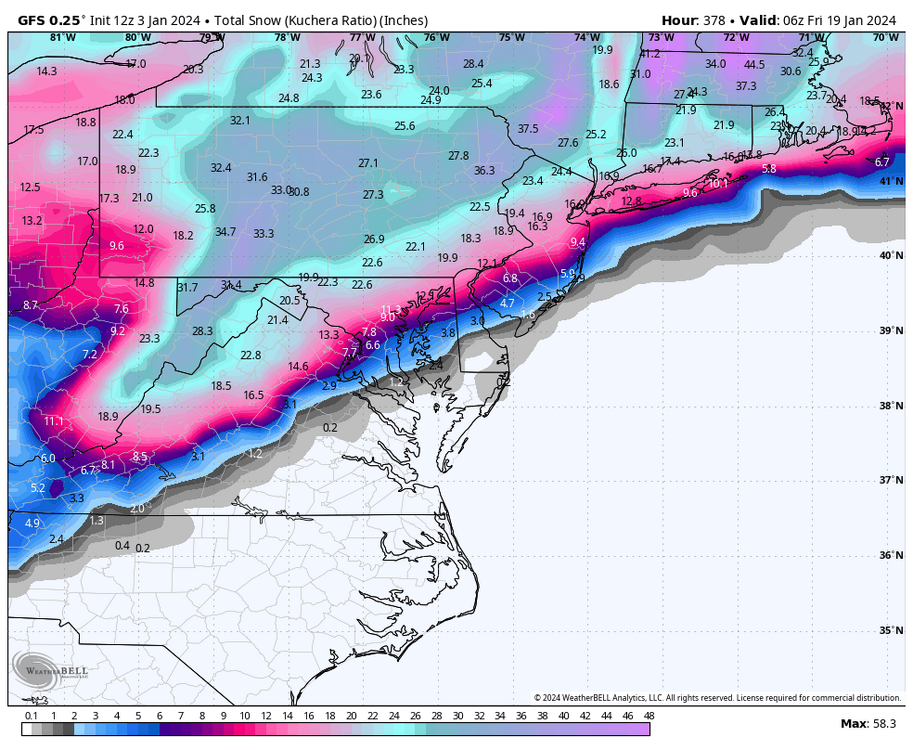
@AccuChrisGlad to see you in here. This is really the only other forum I care to read
besides our Wx/Disco forum. I thought Gary would have us up for the upcoming storm,
but not yet.
-
 1
1
-
-
Have over and inch here, about 10 miles north of Allentown. Coming down hard
-
Steady snow here in Lehigh County. Currently 32° from a high of 36°earlier this morning.
Sticking to everything...
-
Steady snow here and 31°..

-
Steady snow and 31°. Going to enjoy it while it lasts.
-
3
-
-
Snowing here near Allentown
-
Snow has broken out here in Lehigh Valley... 29°
-
1
-
-
12 minutes ago, ChescoWx said:
WXSIM for East Nantmeal Twp with 12z data
Sunday night: Dense overcast. A mix of snow and sleet likely in the evening,
then a mix of freezing rain, sleet, rain, and snow likely after midnight.
Breezy. Low 26, but temperatures rising after midnight. Wind chill ranging from
15 to 26. Wind east-northeast around 10 mph, gusting to 17 mph, in the evening,
becoming 16 mph, gusting to 22 mph, after midnight. Chance of precipitation 80
percent. Snow or ice (on ground) accumulation 3 to 5 inches. Above-ground freezing rain accumulation
up to 0.6 inches.
Monday: Dense overcast. A mix of snow, rain, and sleet likely in the morning,
then a slight chance of snow in the afternoon. Breezy. High 34. Wind chill
around 23. Wind southwest around 11 mph, gusting to 18 mph, in the morning,
becoming 17 mph, gusting to 28 mph, in the afternoon. Chance of precipitation 80
percent. Precipitation (liquid equivalent) mostly around a quarter of an inch.
Snow or ice (on ground) accumulation about half an inch.Any thoughts about the Lehigh Valley? Thanks !!!
-
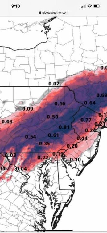
7 minutes ago, Snowcane21 said:
Yep. NAM shows a serious ice storm for Allentown. Not a surprise. Still a precarious situation for N and W zones....
We are still sitting on about 18 inches of compacted snow up here. This is not going to be pretty. There is a glaze on
everything from last night freezing drizzle and fog. Going to be a mess...
-
10 minutes ago, anthonyweather said:
Trouble in the northern areas
12z nam
That's a lot of ice
-
4 minutes ago, KamuSnow said:
Weenie radar shows it snowing here, but alas...lol. Still holding out hope for sleet. Sounds like south of us they're getting more sleet under the heavier returns.
Reports of steady sleet in Lancaster...
-
2
-
-
7 minutes ago, Newman said:
Any reports from northern Lehigh county around Northampton, New Tripoli, etc?
I'm in Orefield. I have 11 inches so far. Heavy snow coming down. I have already ran the snow blower twice this morning
Just go in and everything I cleared is already coated again. LOL
-
2
-
-
9 1/2" in the tube. Heavy snow. Temp 21° Winds N/E at 22 mph .
-
1
-
-
Moderate Snow here in Orefield, PA. ( 7 miles north of Allentown.)
-
Snow coming down at a moderate rate here in Allentown, PA. Coming your folks way soon...
-
13 minutes ago, Tatamy said:
12z NAM has totally missed this initial burst of snow. According to it the Lehigh Valley (I am in Bethlehem Twp.) gets no snow today. It's only 9 AM and a lot of models have already busted on the day. I am at 1" myself and it is still coming down. The 12z HRRR has trended colder for the area near I-78 in eastern PA and NJ.
Fingers crossed.


2/13 rain to snow event
in Philadelphia Region
Posted
Snowing hard Here. Ground is covered. Temp 33°.... Here we go!!!")