

Avid6eek
-
Posts
135 -
Joined
-
Last visited
About Avid6eek

-

Richmond Metro/Hampton Roads Area Discussion
Avid6eek replied to RIC Airport's topic in Mid Atlantic
There is no SE ridge that pumps up over consective model runs to push the low further NW. Everything is going to be dictated by where the low cuts off and the natural thermal gradient between the coastline and gulf stream. Just my $.02. -
Richmond Metro/Hampton Roads Area Discussion
Avid6eek replied to RIC Airport's topic in Mid Atlantic
Being a cutoff upper low and not a shortwave passing off the coast, I don't think the standard NW trend applies here. If that is what you are pinning your hopes on, expect dissappointment. It's just as likely to be further east as it is west. -
Richmond Metro/Hampton Roads Area Discussion
Avid6eek replied to RIC Airport's topic in Mid Atlantic
I'm happy with where things are today. If I could lock in the 12z GFS blizzard-cane I would. Hopefully this week's cold weather will cool the coastal waters down enough to put us in an even better position when the time comes. I'd much rather have a howling N wind off a 32'ish degree Chesapeake Bay than the current 40'ish degree bay.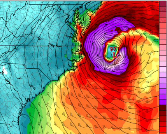
-
Rain/Snow mix in Chesapeake, VA - 38.2/28.6
-
First sprinkles in Chesapeake, VA. Went from 43.9/24.4 to 39.4/27.8 in the last hour. More than 3 degrees of that drop came in only 30 minutes.
-
Reporting heavy virga here in Chesapeake, VA. 44/24.

