

nflwxman
-
Posts
1,557 -
Joined
-
Last visited
Content Type
Profiles
Blogs
Forums
American Weather
Media Demo
Store
Gallery
Posts posted by nflwxman
-
-
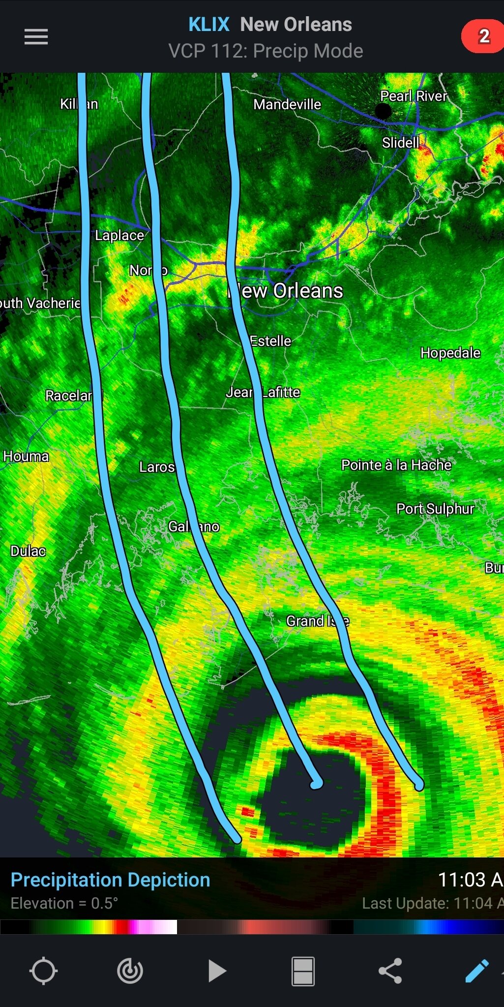
1 minute ago, HKY_WX said:
What I'm thinking
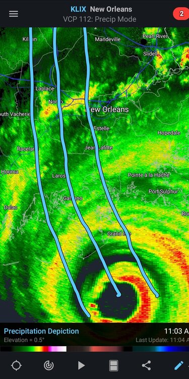
Certainly more of a northward turn at the moment on radar - this is pretty close to what's currently modeled on the high res models, which brings 110 mph + gusts to downtown New Orleans.
-
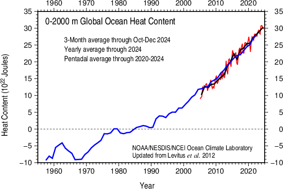
I suppose this is the part where a smorgasbord of usual suspects suggest a short term hiatus disproves the seriousness of AGW. This was the same argument that played out in 2011-2014 and it didn't work out well last time for the naysayers.
Please refer to the 2012 or 2013 global temperature thread if you want to read prior erroneous declarations from posters.
-
 3
3
-
 2
2
-
 1
1
-
-
0.75" in Riverdale. Sticking to all surfaces and pouring snow.
-
Starting to accumulate on everything but roads here in Central Riverdale.
-
1
-
-
2 minutes ago, Islandersguy said:
Snowing the hardest I’ve seen all day in White Plains. Less than a quarter mile visibility. Looking the the base reflectively and it looks almost like we are getting LI sound enhanced snow right now.
Although I am south, I'm noticing that too. It's still snowing moderately here even without obvious returns.
-
Still light to moderate snow in Riverdale. There is some formation of lighter bands coming from the SE that should keep us broadly in the game the next few hours.
-
Heavy snow in Riverdale - ~12.8" ONG. Flake size is noticeably larger. A pivot would be real nice right now.
-
1
-
-
The HRRR is a particularly low skill model with a meandering coastal low. For example, look at this 7 hour forecast of the current (10AM) radar. Not a very good representation of the mixing line and the intensity.

-
2
-
1
-
-
3 minutes ago, HVSnowLover said:
Light snow still. Eyeballing it’s about 4 to 5 inches
Bummer. That's pretty low regionally. Hopefully you make it up on the pivot band coming through in an hour or two.
I would say we are a hair over 7" here.
-
1
-
-
5 minutes ago, HVSnowLover said:
I’m at border of Yonkers/Bronx near Woodlawn it’s snowing but I wouldn’t say puking snow.
I'm in the lower W 230s. It has just lightened up, but it's mostly been heavy or moderately heavy since about 7 AM. A few miles has made the difference in this storm thus far. Overnight we probably only got 2-3", while CPK was 5".
-
Just now, BxSnowWx37 said:
I'm in the northwestern bronx and its been puking snow for almost 3 hours now. Easily above 7 inches,maybe even 8.. mega bands are also incoming..either way I predict over 20 inches for the bronx..some spots over 2 feet.
I'm in Riverdale. Definitely concur. Last night underperformed up here due to dry air, but this morning has more than made up for it.
-
2
-
-
Any one have observations from the New Brunswick area? The radar there is insane and the HRRR is spitting out 6" hour rates.
-
2
-
-
Just now, sussexcountyobs said:
Hmm? Where are you? Down by LBI , or right by the ocean somewhere in south Jersey?
Need to specify the location. It's snowing in Long Branch ATM.
-
2 minutes ago, SnoSki14 said:
That wouldn't be rain it would be a dry slot. Probably freezing drizzle.
Yeah all the frames with "rain" are essentially <0.01" of QPF on the Euro. That's the typical frizzle you get after big storms, and I do expect it to happen here. Could it compress the pack? Sure. Another reason to make sure you measure frequently with this storm, as it's a long drawn out event.
-
1
-
-
All snow here in Riverdale. Coming down light to moderately now. I'd guess about 1/4" accumulated on non-pavement surfaces.
-
1 minute ago, jfklganyc said:
Still have a consistent band sitting over me.
I stopper shoveling because it keeps falling.
Not quite over yet
Yeah this is pretty wild. It's crawling at like 5 mph to the SE.
-
1
-
-
Honestly pretty good rates here in Riverdale with this final band. We may pull out 1-2" more. Nice surprise.
-
Just now, Snowlover11 said:
Moderate snow again in yonkers
Same here in Riverdale. The wind is nuts right now.
-
9 PM - 5.7” in central Riverdale
-
Just now, jm1220 said:
Apparently-dry air was fast to head into PA which often happens. Models have even been hinting at the sleet racing north into PA today before here probably due to the lack of precip and lift holding the warm air back.
I think the high is actually just a bit too far east. The CAD (at all levels) is favoring the NE portions of our viewing area.
-
Final Call:
KTTN 3-6"
KNYC 6-9"
KJFK 4-7"
KMMU 8-12"
KHPN 10-14"
This track historically does not give coastal sections high ratio snows. It's hard to see how mixing does not make it to the lower HV with a 700mb low track this north. The 3km NAM has a fairly significant warm layer at 700-800mb that, at this stage, is more often correct.
-
7
-
-
7 minutes ago, winterwx21 said:
I would think the worst case scenario for our area would be a 4 to 6 inch thump before the changeover, due to the very cold air in place. I'd be stunned if we got only an inch or two. Right now even the warmest models, like NAM and RGEM, give us about 8 inches before mixing.
People tend to extrapolate trends linearly with the expectation that the next run will also have a 25 mile northwest jog. Fortunately for snow lovers in our area, that is not how modeling has ever worked.
Looks like a significant storm for everyone north of Trenton. This "game over" stuff is bizarre.
-
4
-
-
1 minute ago, jdj5211 said:
So we're about 36 hours from the storm and we generally have no idea what's going to happen? And by that I mean, who is getting shafted, where the heaviest precip falls, is there a dry slot, is there a jackpot zone? Is that fair to say.....
I don't think I've ever seen a dry slot location modeled correctly 40 hours before the a winter storm. If you see one modeled over your house on one of the mesos 12 hours before game time, then there may be cause to worry. These are very dynamic events laden with moisture.
-
2
-
2
-
-
19 hours ago, WarmNose said:
I see the heat mongering has been tempered here in the past few weeks. I’ll just leave this here
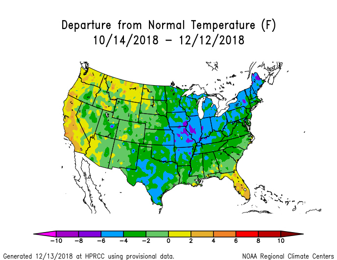
Thanks for placing a map of less than 2% of the Earth's area in the Global Temperature thread. Super duper helpful.
Two Mdt to high impact events NYC subforum; wknd Jan 6-7 Incl OBS, and mid week Jan 9-10 (incl OBS). Total water equiv by 00z/11 general 2", possibly 6" includes snow-ice mainly interior. RVR flood potential increases Jan 10 and beyond. Damaging wind.
in New York City Metro
Posted
All snow here in Riverdale (Bronx). Temperatures started a bit warm this morning, so i'm not expecting much stickage here outside of unpaved surfaces. Still 34/30.