

weatherbear5
-
Posts
289 -
Joined
-
Last visited
Content Type
Profiles
Blogs
Forums
American Weather
Media Demo
Store
Gallery
Posts posted by weatherbear5
-
-
15 minutes ago, jm1220 said:
Yep it’s pouring here in Long Beach. Not as hard as last night but enough to I’m sure flood some basements. I checked out the waves-maybe 5-6 footers but 2 days before Sandy they seemed twice as high.
Sandy was a HUGE storm with a huge wind field, this is a relatively tiny storm with a small wind field, not surprised the waves are much smaller
that stationary rain band was what I was worried about. LBI looks like it’s getting hammered
-
If this thing does end up stalling like the NAM suggests, wherever those bands pivot and train over are gonna be in trouble… I think there’s at least a chance that happens over the island, which is where my comment about “severe flooding” from before came from
of course, it could also stall with the bands north of the Island as well
-
10 minutes ago, psv88 said:
Where will there be severe flooding? From the rain? Long has Sandy soils which drains well. There are also few rivers and creeks which flood. Most of the island can handle 5” of rain without a problem…10” and you will see issues
I’d wager someplace on the Island will see a foot plus of rain
-
I’m beginning to get VERY worried about severe flooding on the Island… this could be very bad…
And with that threat, even if winds aren’t that strong they could still take down trees
-
7 minutes ago, NJwx85 said:
The GFS is banking on a much weaker storm and that’s a big reason it’s so far East.
Well yeah, my point was at this point in time it wasn’t crazy.
With that being said, it looks as good as it has structurally, and convection is finally starting to burst in the southern half of the eye wall… need to watch this closely since if it does manage to strengthen rapidly it would change the equation
-
3 minutes ago, Snowlover11 said:
wow at that 984 reading
18z GFS had it at 984 at 00z, doesn’t seem like it was unexpected
-
 1
1
-
-
Let’s see if that deep convection that fired in the southern eye wall can wrap around the eye. Seems like it may be trying to ward off some dry air. If it can do so, it still has some room to strengthen
-
Deep convection just fired along the southern edge of the eye. We’re not out of the woods yet when it comes to potentially strengthening
-
2 minutes ago, psv88 said:
Where in NW Suffolk. Back and forth here in commack, doesnt seem like we will make the flip
Pretty much right on the Nassau/Suffolk border
starting to accumulate on the driveway now
-
All snow here in NW Suffolk
doesnt appear to be sticking to anything attm though
-
3 minutes ago, CoastalWx said:
I think what CC was seeing could be some partially melted, or flakes with a layer of water on them. Those big fat aggies. It does look like the real mixing is well SW of the city.
Yeah. Water on ice = crazy correlation coefficients
-
7 minutes ago, ARyan said:
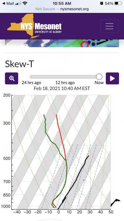
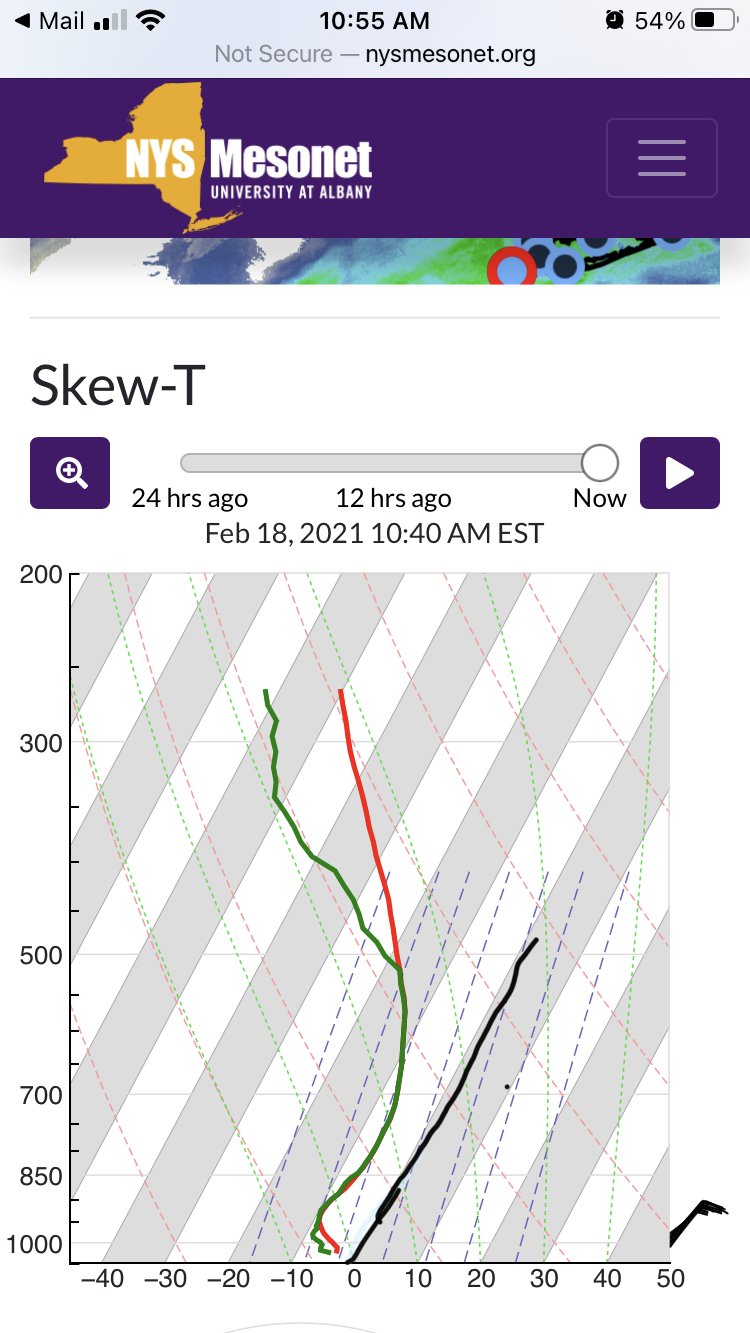
LIDAR soundings in the metro are already looking sketchy. Temps in the 700mb level are flirting with 0C. The heavy snow will help, but if/when things lighten up is when we'll be in trouble.
I think you’re confusing the mixing ratio line with the 0C temperature line
-
4 minutes ago, MJO812 said:
Gfs is a big sleet storm for the coast
Looking at soundings, that could easily be FRZA
-
1 hour ago, hazwoper said:
that looks wayyyy different on Tidbits....
On Tidbits it’s only “model derived”. That map is 10-1
also, it only seems to show rain and snow. 2-M temps are below freezing verbatim, even on the Island until after 12z Tuesday
-
1 hour ago, NJwx85 said:
Weenie maps are for weenies. That's not just for snow, but for all precip types.
The soundings mostly support plenty of sleet and freezing rain for the whole area.
Freezing rain is more likely closer to the coast where the cold air is shallower. I would still favor mostly plain rain for the city but the surface temps on the GFS sure give me pause for concern.
The GFS is usually too warm at the surface.
The scary thing about this setup is that models are notoriously bad at estimating WAA above the surface and CAD at the surface
Methinks this has the makings of the biggest ice storm a lot of areas have seen in a while, particularly at the coast
Heres hoping it trends colder aloft for more sleet or snow than FZRA
-
That high is in a perfect spot to lock in cold air at the surface. That’s the look of an ice storm right there, unless we can get the mid levels to cool
-
1
-
-
Also, with that banana high to the north, be wary of surface temps being warm on the models... 99% of the time winds are more northerly than the models show, and therefore colder temps
-
 1
1
-
-
We need more of the PV to stick around because we NEED that confluence to keep this from cutting. You have a beautiful split-flow which will result in strong high pressure to the north, but without that confluence it becomes a risk for a major ice storm
Energy from the Pacific rotates in and pulls the PV, elongating it and eventually opening it up and sending it into the North Atlantic. If we can keep that anchored over Quebec, it will allow the low to cut under us, rather then into the Lakes
that’s the difference between, say, the 12z GFS (cutter) and 12z CMC (coastal)
-
1
-
-
Pouring snow in northeastern Northeastern Nassau
-
1
-
-
Lots of heavy precip lining up near KDIX radar. If extrapolated, looks like it’s heading towards the western half of the Island for the moment, but should spread the love eastward with time
-
Maybe it’s just the weenie in me, but the radar down by DC doesn’t look so bad
-
2 minutes ago, HVSnowLover said:
Less than .5 qpf for most
Yes, like I said, an ugly run. Slightly weaker, slightly east, less heavy precip. Idk what you want from me lol
-
1 minute ago, HVSnowLover said:
It’s only 6 hours of precipitation and half of it SE of the city is not snow
It’s more like 9 hours, and more like Suffolk County has the severe mixing issues verbatim on the RGEM for the first 2 hours
Once the heavier precip moves in it flips everyone at the coast to snow. Problem is there’s not a ton of heavy precip around at all on the RGEM. Ugly run for sure
-
RGEM looks slightly weaker, slightly SE, and less precip. Though it’s tough to get exact numbers on that CMC collar page
Henri: Moderate-Major impacts NYC subforum this weekend, possibly into Monday August 21-23, 2021
in New York City Metro
Posted
In the wise words of my girlfriend, “size isn’t everything”