

DoctorMu
-
Posts
741 -
Joined
-
Last visited
Content Type
Profiles
Blogs
Forums
American Weather
Media Demo
Store
Gallery
Posts posted by DoctorMu
-
-
Potential freeze in south Florida next week, also. Buy up OJ while you can!
-
9 hours ago, aggiegeog said:
We may be looking at sub 20 degree highs early next week almost guaranteed sub freezing highs for multiple days.
Will be brisk for sure.
College Station may see lows in the teens, and subfreezing for 2 days.
-
2 hours ago, wxmx said:
And during my bday to boot ;)....Most probably it will be gone in one of the next few runs.
Unfortunately, yes.
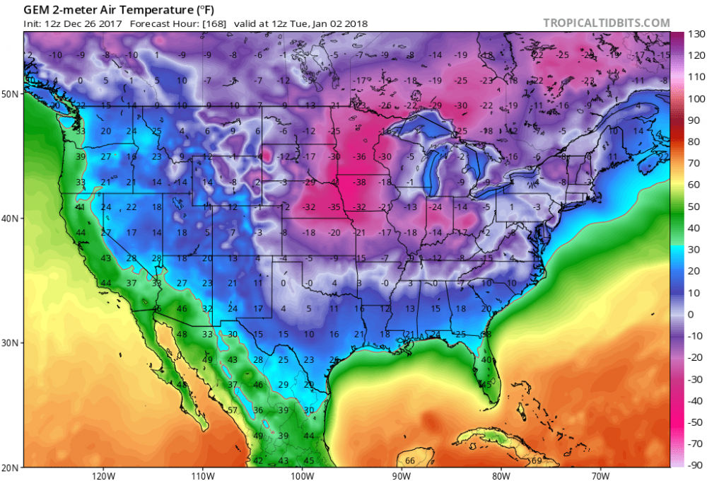
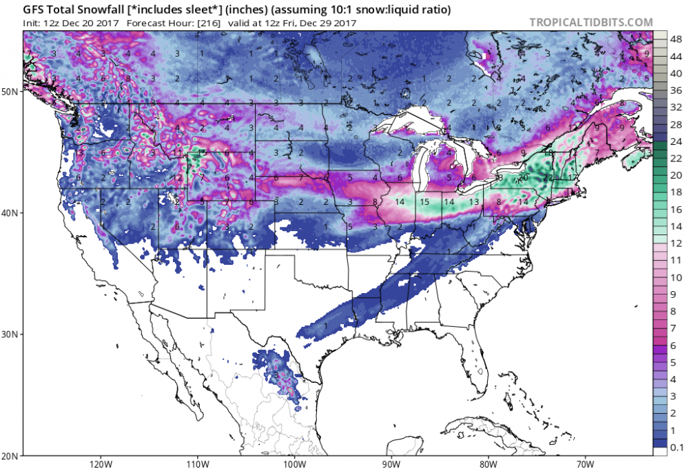
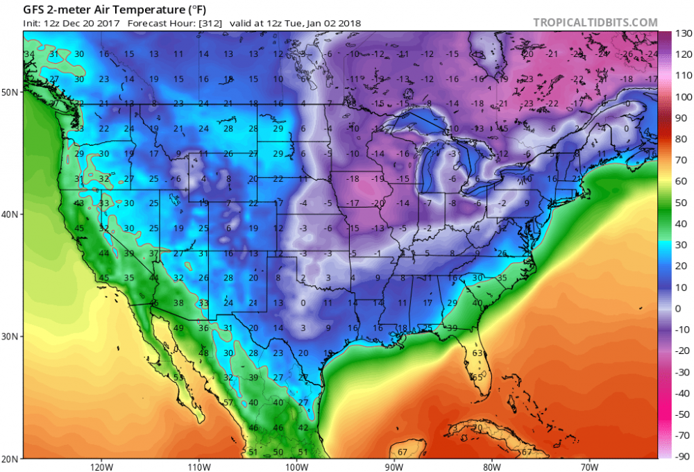
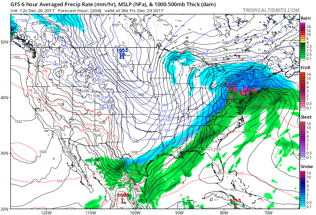
Our snowfall disappeared in 24 hours, but what a fabulous 24 hours! Two miracles in one season are probably too much to hope for. The models and ensemble do show a prolonged cold snap from the 28th through Jan 5...so opportunity for mischief awaits.
.thumb.jpg.7d2dbb6b5bb4ff57cccc4aef2e34901a.jpg)
-
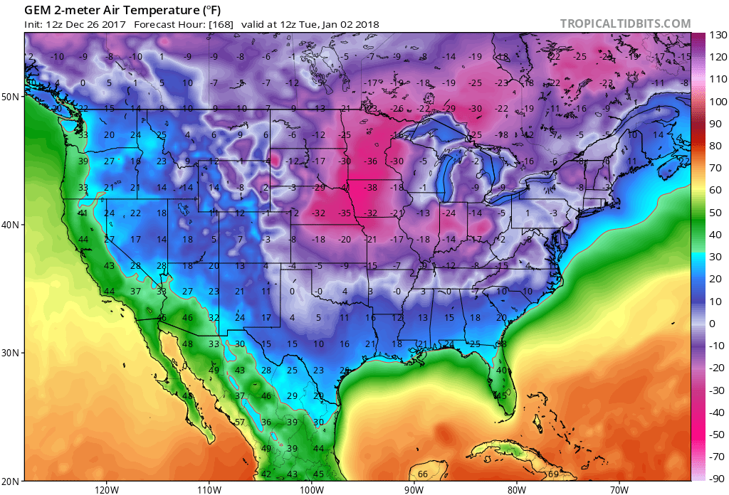
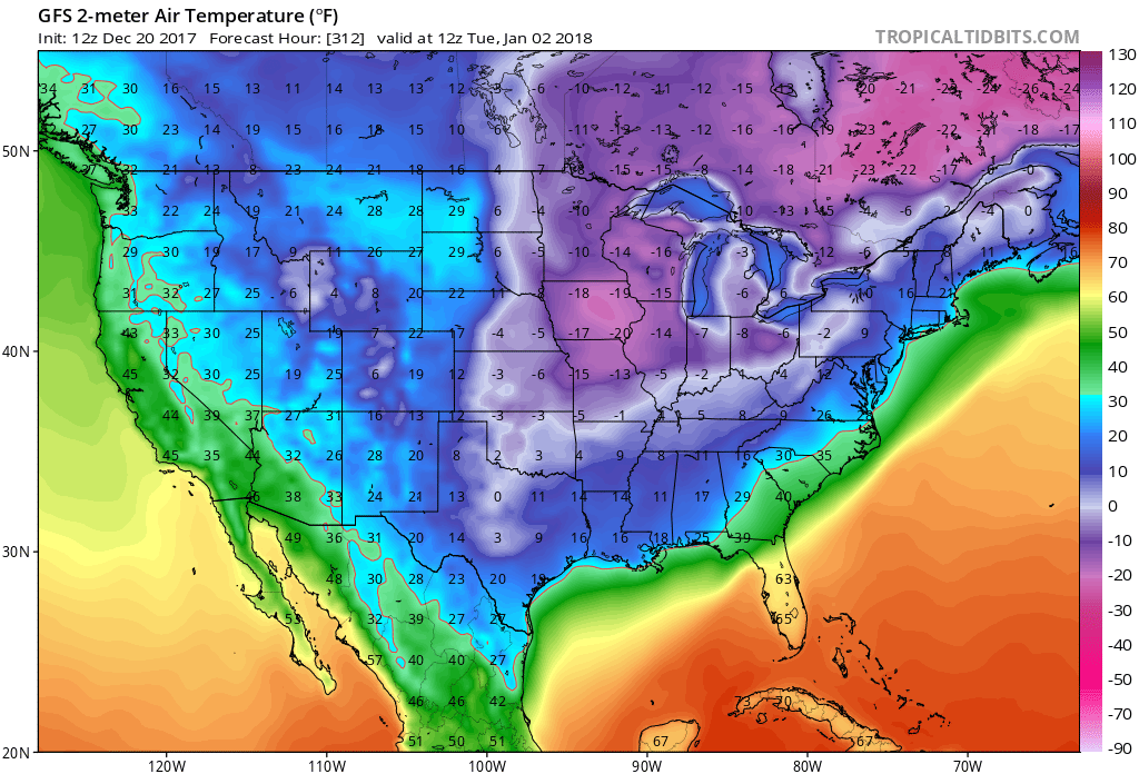
wxmx may enjoy the latest GFS run. We've had one 5 inch miracle snow already in CLL this month!

Temps in early Jan get even crazier. Entertaining run!
-
On 2/12/2017 at 6:22 PM, Quixotic1 said:
Well, climo is working against us. The cfs and cansips are ghastly. I got nothin. We sit at 11 freezes at DFW. We technically have about 6 weeks to get three freezes but i see nothing hopeful. 14 is the fewest. be afraid. Be very afraid.
This is the best I've got. Just a freeze. In the distance. Besides for 2 cold days an a 17°F low, the coldest in College sSation in a decade...we've got nothing.
After a few days of cloudy, cooler, and rainier weather - back to August doldrums. High humidity, temps, heat indices. zzzzzzzzzzzzzzzzzzz
Area Forecast Discussion
National Weather Service Houston/Galveston TX
616 AM CDT Thu Aug 10 2017

.DISCUSSION...
Some patchy fog at KLBX and KCXO has produced some brief MVFR
conditions, but the fog is shallow and should burn off between
13-14z. The HRRR is bullish with rain chances today along a
developing sea breeze boundary. Fcst soundings show PW values
between 2.00 and 2.10 inches but the moisture profile looks dry.
A weak cap was noted near 850 mb, but the cap looks breakable
with heating. Have kept the VCTS for areas for southern TAF sites
but have removed the mention of precip from KCLL, KUTS and KCXO.
VFR conditions expected tonight with some patchy fog again
possible at KCXO/KLBX toward sunrise. 43

&&

.PREV DISCUSSION... /ISSUED 332 AM CDT Thu Aug 10 2017/

DISCUSSION...
A passing shower or two along with some patchy fog will be
possible early this morning, primarily across the Piney Woods
region. Ridging begins to take hold of the forecast today, helping
us return to a more typical summertime pattern. Could still get
some scattered showers and storms both today and Friday, primarily
along the sea breeze. Rain chances become more limited heading
into the weekend as the ridge remains overhead. With the lowering
chances for showers/storms, high temperatures will be on the rise
for much of the forecast period, generally ranging from the upper
80s right along the coast to the mid/upper 90s across the Brazos
Valley. Light to moderate south to southeasterly flow throughout
the upcoming week will keep humidity high, allowing heat index
values to surge into the 103-109 degree range during the
afternoons. Right now, Friday and Saturday are forecast to have
the highest heat index values, and heat advisories may be
required.
-
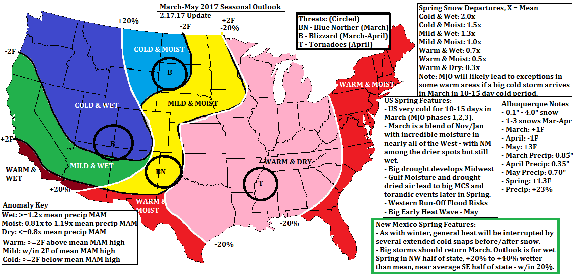
12 hours ago, raindancewx said:
This is my updated Spring Outlook for anyone curious. Have much of the Midwest & TX dry, with heat generalized east of the Rockies. Expecting one-two wetter months in NM given the persistence of storms since November.
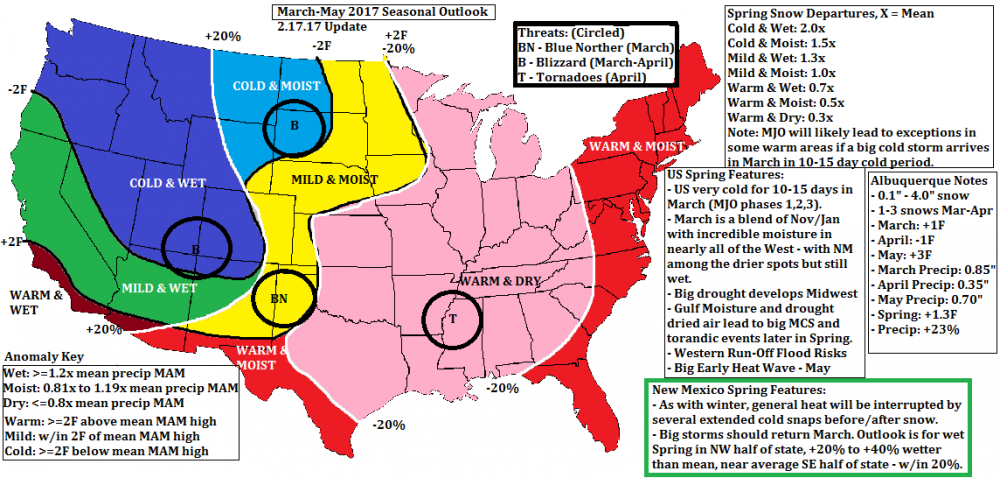
That doesn't bode well for summer in Texas. If the foliage dries out before summer, it will be a scorcher - even more than the usual.
-
4 hours ago, Quixotic1 said:
Well, climo is working against us. The cfs and cansips are ghastly. I got nothin. We sit at 11 freezes at DFW. We technically have about 6 weeks to get three freezes but i see nothing hopeful. 14 is the fewest. be afraid. Be very afraid.
This is the best I've got. Just a freeze. In the distance. Besides for 2 cold days an a 17°F low, the coldest in College sSation in a decade...we've had nothing resembling winter.

-
15 hours ago, Quixotic1 said:
Yeah, I wish I had the data at my fingertips but the best way I can describe it is a stratospheric tendency. If you've got a strong force teleconnection wise such a strong El Niño or strong La Niña, the QBO isn't going to change it. However it can be an additive force. A strong with a +qbo is just going to amplify the enso signal. If it's negative, the hope for blocking is much better. When the Qbo kept going positive my heart sank. Just another nail in the coffin. Next year we should be negative. Emphasis on "should".
Yeah, who knows. The QBO cycle appears to be disrupted by climate change...
-
Snow in Big Lake moving towards Junction. Not sure it will reach the Hill Country. Mountains in northern Mexico could be in for a treat.
http://www.corad.org/kftw_base.htm

-
GEM has single digits in DFW area Saturday.

-
Hoping for a miracle as far south as College Station. It might take the coastal low to dust us. (sorry DFW gang). 2010 was the last frozen stuff that stuck.
Expecting a mix though Friday night.
-
Euro, GFS, GEM running colder with more precip.
I'd take light wintry stuff in CLL - rare as it is.

-
12 hours ago, bubba hotep said:
Just a slight change from 00z to 06z...

Just...a bit outside!
-
Think we'll see a warm and dry winter. However, there should be occasional polar blasts as Siberia is already in the deep freeze with a mammoth snow pack.
-


Area Forecast Discussion
National Weather Service Houston/Galveston TX
350 PM CDT SUN JUL 24 2016

.DISCUSSION...
The key issue in the forecast will focus on an incoming trough
that will bring the most serious rainfall potential in some time
to the area. However, while confidence is high in the first half
of the week - particularly Monday - bringing higher rain chances,
there is continuing uncertainty about fine details. There
continues to be divergent model guidance for the rebuilding of the
ridge in the wake of the trough`s passage, which has implications
for both lingering rainfall potential and high temperatures deeper
into the week.

Today into Monday...
Despite the appearance of less capping, showers and storms have
struggled again to get going this afternoon. While more development
has occurred than yesterday, convection has continued to be more
widely scattered than perhaps first anticipated. There should
be some further increase in coverage into the early evening, but
loss of heating will cause convection to wrap up. The WRF-ARW
has backed off late evening precip in the area, which seems
reasonable based on observational trends today, and have not
bumped PoPs up north. Focus then turns to the approach of both a
vort max from the Mississippi Valley and a TUTT low that`s working
its way across the Gulf from the east. Ultimately, took a bit of a
middle road in bringing up clouds and precip chances through the
morning, but focused on putting likely PoPs more in the afternoon.
For the most part, temperatures are cooler than previous days, but
still brought the westernmost counties up into the middle 90s on
the thought that clouds/rain will be late enough to get a bit more
heating in. Still, faster timing could make this a bad move.

Monday night through Wednesday...
As the inverted trough works its way deeper into Texas, there
becomes a divergence in the guidance as to how long upper weakness
in the height field continues. The GFS builds things back a little
more quickly, and while Tuesday carries relatively high rain
chances, things quickly get back to resembling the diurnal
seabreeze pattern. The Euro, on the other hand, keeps the ridge
from building back quite so quickly, and stays more wet. The GFS
appears to handle the transition more awkwardly, so the forecast
hedges towards the Euro. However, a deep reading of the PoP grids
does show slightly lower chances well inland from the seabreeze
zone in deference to a scenario with a stronger ridge.
Temperatures are cooler than normal, but still in the vicinity of
90 degrees.

Thursday into the weekend...
Model divergence continues to spread in the extended, keeping
confidence on many details low. The GFS continues to be towards
the drier edge of the guidance envelope, and even cuts off
seabreeze convection by early next week. The Euro, on the other
hand, swings the other way, keeping more widespread rain in the
forecast straight into next week. For what its worth, this is at
least a step forward from yesterday, in which the GFS and Euro
took turns flipping places with each other from run to run. While
a fan of how the Euro handles to exit of the inverted trough
earlier, am wondering if it is falling a bit towards its old trap
of not being quite progressive enough in the long term. Thus, the
forecast takes a bit of a middle road here - splattering some
amount of PoPs through the period, but focusing more on the
seabreeze zone. This may not be the most realistic of scenarios,
but am aiming to be more probabilistic rather than deterministic
here, as this allows for an easy pivot either way as confidence
in the preferred scenario becomes higher. Have trended
temperatures upwards, but the degree to which we warm will again
be dependent on rain coverage.
25

&&

.MARINE...
Light wind regime in place across the area. Deep moisture
spreading into the area will lead to an increase in showers and a
few thunderstorms tonight especially toward morning. May see a few
short-lived waterspouts Monday and Tuesday morning. Light
landbreeze possible again around Galveston Bay. Onshore flow will
dominate the wind field across the area through Thursday with
winds varying from southwesterly to southeasterly being mainly
diurnally driven. Rain chances taper down Wednesday. 45

&&

.PRELIMINARY POINT TEMPS/POPS...
College Station (CLL)      78  95  76  92  75 /  20  50  30  60  30
Houston (IAH)              79  94  78  92  76 /  20  60  30  60  30
Galveston (GLS)            82  90  82  88  82 /  30  60  40  60  30
-
3 hours ago, bubba hotep said:
Y'all hold it down in DFW! I'm at the beach looking for storms
Watch our for these!
-
Not like there isn't plenty of moist, disgusting air to be tapped here in Austin. Looks like CAPE should be sufficient for storms here, but the line's crawling south. I guess we'll see what happens. There's been zero rain where I am in about two weeks, and the ground's already looking parched with the daily 100 degree heat we've been having. Hopefully this doesn't turn into another severe flash drought like last summer which resulted in wildfires by early fall.
The western cluster is merging and hanging together as it moves below Killeen. I'm concerned about the eastern side as weakening cells may slide just east of us between CLL and Huntsville.
-
Good line of storms look to be headed south from Lampasas-Waco. Hopefully they make it here, can't believe I'm saying it but we could use the rain!!
I saw the anvil and lightning about an hour ago. The broken line is approaching Hearne.

-
We could use more rainfall in CLL, although not the massive electrical storm from last week. The heat index has been about 105°F+, but highs have not hit upper 90s yet. Agree the effects of the wet ground and overestimation of some of the ridging by NWS.
-
Little chance of rain in south central and SE Texas until the 14th of July, and what little there is on the models is near the coast.
Brutal heat wave in the SE US settles in near mid month.
Monsoon season precip models - the July 4th weekend looks like a good time to begin...maybe a little extra MoJO.
.jpg.44406a45264410008f3ea725f092b59b.jpg)

Texas/New Mexico/Louisiana/Mexico Obs And Discussion Thread Part 8
in Central/Western States
Posted
It's snowing in Cleburne, freezing drizzle in Waco.