

Anduril
-
Posts
816 -
Joined
-
Last visited
Content Type
Profiles
Blogs
Forums
American Weather
Media Demo
Store
Gallery
Posts posted by Anduril
-
-
Really windy actually lol
-
Lines about to go through Camp Hill but other than wind I aint seein much
-
4 minutes ago, Jns2183 said:
Do you normally wake up at 5?
Sent from my SM-G970U using Tapatalk
Its not normal to wake up (or be woken up) between 5-6am on the weekends?

-
I cant believe how much that line died crossing the mountains. Someone got a bunch of dehumidifiers running out there?
") Lets hope that the line the NAM 3k develops actually happens or we're gonna strike out hard today
Lets hope that the line the NAM 3k develops actually happens or we're gonna strike out hard today 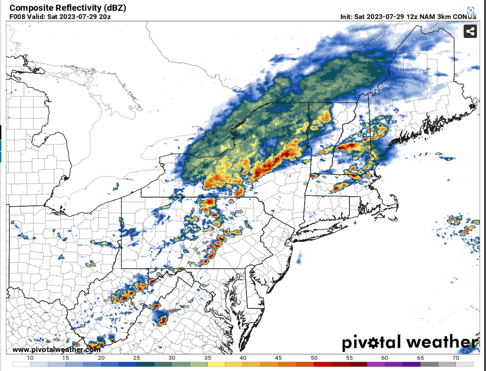
-
 1
1
-
-
5 minutes ago, sauss06 said:
he's a lil premature
Guess it happens with age
-
 1
1
-
-
Just now, canderson said:
91 at 1240
You living in the future?
")
-
Nice cells popping near Elizabethtown and Dillsburg wonder if anything will spawn further north/west (not betting on it)
-
Suns popping through let the warmup begin EDIT: 87F already
-
4 minutes ago, Mount Joy Snowman said:
Yeah it looks like they want to pop stuff more out my way and even points south and east from here. Not sure anyone west of the river sees much activity. But as always, we shall see.
Watered my tree this morning as the ground was hard pack. Within 30mins it was just...gone
 Not drought conditions but still dry
-
1
-
-
Pretty disgusting morning temp/humidity wise I have to say. Heavily cloud covered at the moment but temps steadily climbing from 76 at 6am to 81f now. Be interesting if/what storms develop this afternoon. HRRR/NAM/HRW FV3 dont seem too interested in anything except maybe into the far eastern reaches of the state for today
-
1
-
-
12 minutes ago, Mount Joy Snowman said:
Good morning folks. I've been a bit out of the loop weather-wise the past few days. I was surprised to see so much action on the radar this morning. Although, nothing has fallen here yet. Are we still in for a severe threat later today? Record highs for both Thu/Fri at MDT are 99. Doable? National high of 124 at Stovepipe Wells, CA and low of 40 near Sand Creek Station, OR (whoa that's a high low).
NAM 3k showed a decent line of storms going through this afternoon/evening
-
4 minutes ago, Itstrainingtime said:
MU's Elliott on the remainder of summer:
By the end of next week, the large, semi-permanent Jet Stream ridge that has been responsible for the recent stretch of brutal, record-breaking heat cross the southwestern United States may shift into the central U.S. and expand its grasp over most of the nation. If this comes to fruition, then a bonafide heat wave could occur during the last few days of July, and more extreme heat could be lurking in August. Odds favored the second half of this summer being much hotter than the first, and it certainly appears that that will indeed be the case.
Can we ban you for bringing that evil info here?
-
1
-
-
59 minutes ago, Jns2183 said:
Anyone have any clue regarding those velocity returns south of Mechanicsburg by dillsburg I posted last night?
Sent from my SM-G970U using Tapatalk
I think based on beam height it was probably measuring winds at 10k ft or more so might not have been mixing down at all
-
I slept through the whole thing
 Even the pup didnt wake up. Got 1.12" of rain
-
We flew back from LA yesterday and it was crazy how dense the wild fire smoke was even over 20k feet in altitude. Basically from like Iowa east all you could see was the wildfire haze. Couldnt see shit when we got into PA lol
-
HRRR wants nothing to do with storms for most of PA today except into Friday morning early hours might be some boomers. NAM 3k sees some develop especially eastern PA. Really would like some rain before the weekend
-
1
-
-
29 minutes ago, canderson said:
GO OUTSIDE.
70, no humidity - feels cool!
Im sorry, what? My station is saying 72f and 89%(!) humidity!
-
1 minute ago, Jns2183 said:
This has all fallen since 1:30
Sent from my SM-G970U using Tapatalk
Yup my station had 0.00 when we got home around 12:30pm today. Impressive storms. Wonder what highest totals are gonna be wouldn't suprise me if we see some 6+ readings in areas
-
Started pouring again. 1.95in
-
Somehow managed to fall asleep over the last hour
 Got 1.47in in the rain gauge so far
-
1
-
-
Driving back from Lock Haven today got just past Lewistown and the heavens opened up. Some of hardest rain I've ever driven through probably should pulled off but couldnt even really see the side of the road to do that. Got down to on 322 Millerstown and it basically shut off
-
1
-
-
2 minutes ago, canderson said:
Ohhhh that’s right, was confusing my suburbs of suburbs
Im like the crack den of Camp Hill Enola is the crack den of East Penn (goin by school districts)

-
1
-
-
Im sorry
39 minutes ago, canderson said:You calling Shiremanstown Camp Hill instead of Enola is like that old Radisson hotel in Camp Hill calling itself the Hershey whatever hotel it’s how called haha

Bro Enola is on the opposite side I'd be more linked to Mechanicsburg than Enola lol
-
Just now, canderson said:
Thunder here for the first time today
We actually had it pretty steady earlier between 5-7
Central PA Summer 2023
in Upstate New York/Pennsylvania
Posted
Slightly chilly on the morning walk wish I had grabbed my sweat shirt. Wish it would stay like this all day (ok maybe warm up to the mid-60s)