

Derek30
-
Posts
223 -
Joined
-
Last visited
Content Type
Profiles
Blogs
Forums
American Weather
Media Demo
Store
Gallery
Posts posted by Derek30
-
-
Latest HRRR runs hinting at discrete supercell activity near/to the south of DFW late this evening into the overnight
-
Starting to unzip in portions of AR and far N LA. That Haynesville cell just went severe warned.
-
 1
1
-
-
Cell near Earth, TX could be the first major player of the day eventually.
-
Starting to get going now

-
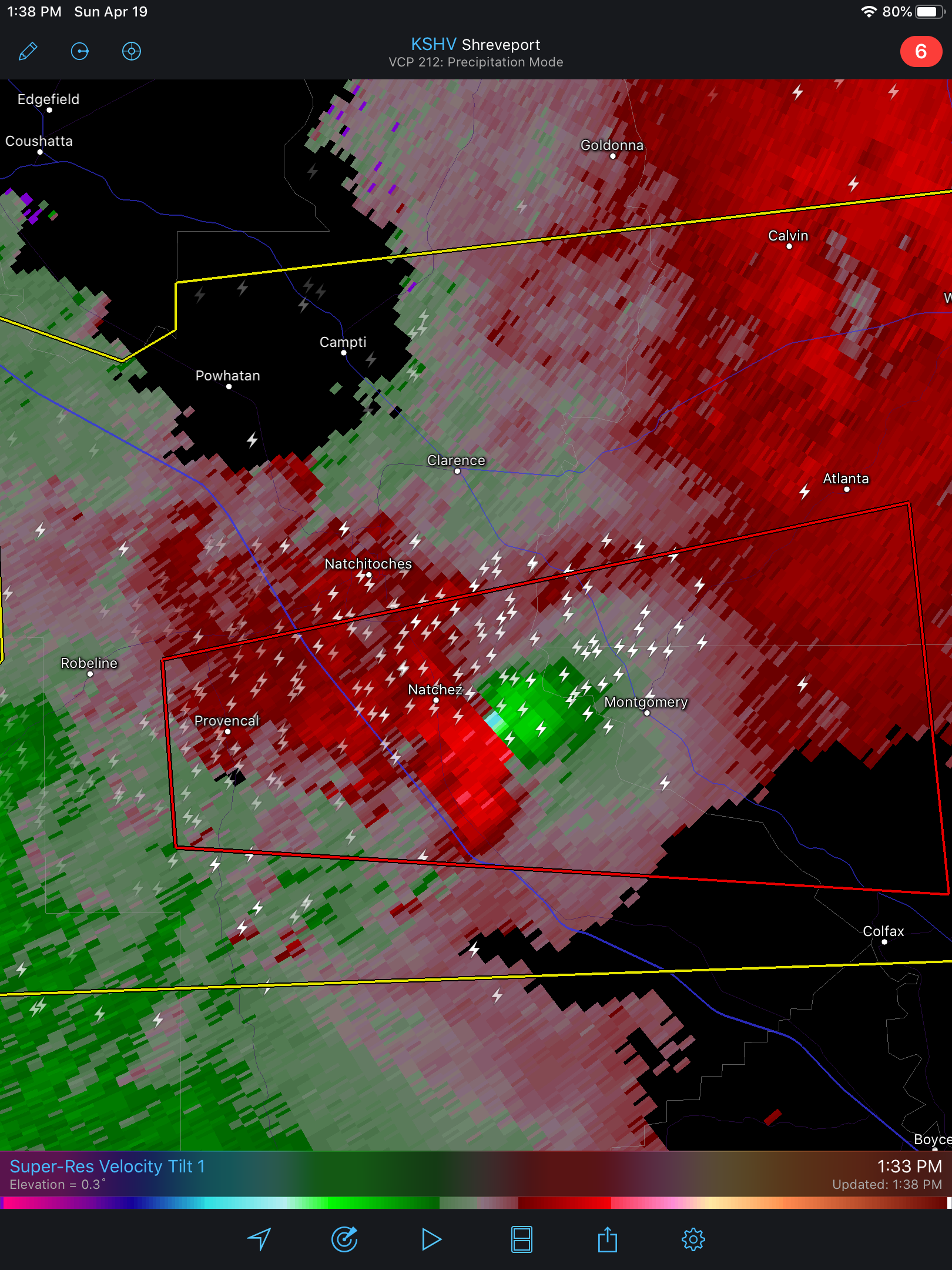
Original Nacogdoches storm tornado warned now
-
6 minutes ago, Indystorm said:
DGX radar showing a definite move n/ne with the storms as the WF progresses northward in MS.
Think it’s pretty safe to assume areas south of Jackson, MS will be primed in the coming hours as the storms in LA progress east. They’ll be heading into a very unstable environment
-
Have an inkling that Nacogdoches storm in E TX might do something as it encounters increasing MLCAPE in LA and eventually S MS. Seems to be pretty close to the warm front at the moment.
S MS seems to be the sweet spot. Already seeing 2000-3000 MLCAPE in a good chunk of the MOD risk area. Bassfield and Laurel unfortunately appear to be in the crosshairs once again
-
8 hours ago, nrgjeff said:
Middle of this week looks like a doable 3-4 day stretch in the Northern Plains. Tue/Wed feature a LLJ somewhat backed approaching/over the region. Moisture may be JIT on Tuesday but should be there Wednesday. Note that 65F dews is enough up there. I will not attempt specific targets due to mesoscale details, but generally Wyoming, Montana, Nebraska and the Dakotas.
Late this week SPC even mentions a short-wave for the Dakotas, Minnesota and Wisconsin Thu/Fri. Nebraska and Iowa could be involved. Best forcing looks north, but boundaries may sag south still with just enough flow aloft. Is the season over in the heart of the Alley? Time will tell, but it looks like the North is perking up even if it's a little early compared to climo.
Could be a decent stretch into next week as well with a rather strong ridge encompassing the eastern US and prolonged SW flow aloft for the northern Plains and southern Canada
-
Leaning towards the GFS solution over the NAM for Friday. Surge of moisture leads to increase in instability especially late into Friday night in MB. Not really seeing a surface based threat but instead a classic MCS/elevated scenario along and north of the warm front heading into Saturday morning.
You folks think southwest MB could be a surface based play at some point Friday? Tough call as models hint at a dying MCS in that area early. MB historically has had a hard time with afternoon recovery behind MCS activity but we shall see.
-
Anyone coming up north in the coming weeks may need to bring their passports. Looks like the potential for a good setup or two in SK/MB ahead.
-
GFS has been hinting at big things for the central and northern Plains in early to mid June. Big time ridge followed by western troughing and the jet shifting north.
-
If stuff does indeed pop in North Dakota on Saturday like the GFS suggests and has suggested for several runs, there will be quite a few nice storms along the warm front axis. Not really any obvious height falls, but a fairly deep low in eastern Montana and lead impulse.
Keep an eye on Sunday as well. Low progresses east and the trough finally approaches. Should be good forcing along with appreciable moisture and instability.
-
Yeah, E SK looks to be the best bet tomorrow and Thursday. Ridge is overhead for S MB with MCS potential increasing both nights. E SK should see a few supercells with the highest risk on Thursday.
-
Thursday looks volatile on top of the ridge in southern Manitoba. Reminds me a bit of a certain setup 9 years ago.
Northern Plains also look active next weekend as the ridge breaks down. 6z and 12z GFS depicting a very strong low in ND.
-
it was one of those events where most of the severe weather was in the Lakes/Ohio Subforum and not Central
that page is when Joplin becomes part of the discussion
Thank you!
-
Can someone provide a link to the discussion thread for this event? I can't seem to track it down. Thanks.
-
Good lord. That is one hell of a scary skycam. If this continues to track the way it is, there will be devastation in Tuscaloosa. Hoping for the best!
Central/Southern Plains Severe Weather Palooza (4/29 - 05/05)
in Central/Western States
Posted
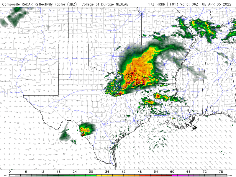
00z HRRR paints an ominous scenario tomorrow with numerous discrete supercells prior to upscale growth into a large bow.
3km NAM, on the other hand, has a lot of early convection in the risk area which muddies things.