
West Point, NY
-
Posts
1,454 -
Joined
Content Type
Profiles
Blogs
Forums
American Weather
Media Demo
Store
Gallery
Posts posted by West Point, NY
-
-
1 hour ago, NYCweatherNOW said:
Come on man I’m not that bad am I? I know I give up late but that’s cause I’m a

I just have a good feeling this time for the rest of the winter.
I know we will turn the corner this week into winter well into March. Just that you are running with clown maps days in advance since November when NYC Ave high was 50 throwing out accumulations and arguing why with nothing but a way off clown map to back you. You become chicken little after awhile. I know you love snow but the board has to be somewhat fact grounded to prevent it from becoming unreadable.
-
 3
3
-
-
2 hours ago, NYCweatherNOW said:
Agreed, but hey I’m a cold weenie and I’m taking that run and running with it. Although GFS is going to shut me down now I’m sure let’s see!
Which means like every other storm that you insist will lead to accumulations in NYC, there will be almost none.
-
1
-
 1
1
-
 2
2
-
-
2 hours ago, jm1220 said:
We’re halfway through Met winter and NYC has under 3”. That’s well below average at this point-about one third of average in fact. By now Central Park should be at 8”. Islip is at 4.7” and should be at 8.8”. Bridgeport’s at 5.7” and should be at 9.2”. We still have a long way to go but it’s not whining to say it’s been a very lousy season so far.
Yes but in statistical reality to balance out the well above decade of snowfall eventually you have to have below normal winters. It is normal
-
3 hours ago, Sugarloaf1989 said:
It depends on location, elevation and exposure. Most of the glacier's are retreating. Grinnell is melting fast. Salamander and Gem glacier are stable.
Jackson increased 25% over the last decade. Point is predictions of the glaciers demise have been wrong for around 90 years. When do these people get taken to task?
-
1 hour ago, Damage In Tolland said:
They say our climate is heading towards what DC is now
They have been predicting that Glacier National Park would be melted down since the 1930s. The National Park Service had to change their last official sign recently which had projected 2020 to now 2040. I'll be taking my first trip to see the glaciers in 2040.
-
1 hour ago, Yukon Cornelius said:
Ha ha - I hope not. But hey, folks that are thinking about moving to Florida when they retire may be able to just stay put, up here. Arctic Circle the new New England...?
They leave more to get away from high blue State taxes. The weather is an added bonus
-
16 minutes ago, Juliancolton said:
This is a wicked warm layer. Mesos seem to be trending back toward a sloppier solution this evening after it looked like a mostly-snow event was possible.

Whenever these come in later than expected it always is at the expense of snow.
-
 1
1
-
-
1 hour ago, NYCweatherNOW said:
Just so we’re all clear, you said nyc is an all rain event right?
Please be careful shoveling your Euro snow. If it's off by a tenth, you may be dealing with a full inch to remove in the city
-
 1
1
-
-
1 hour ago, NYCweatherNOW said:
********************STORM TOTAL SNOWFALL********************

LOCATION          STORM TOTAL     TIME/DATE   COMMENTS
                     SNOWFALL           OF
                     /INCHES/   MEASUREMENT

CONNECTICUT

...FAIRFIELD COUNTY...
   NEW FAIRFIELD          6.7   400 AM 12/03  TRAINED SPOTTER
   BRIDGEPORT AIRPORT     2.0  1200 AM 12/03  CO-OP OBSERVER

...NEW LONDON COUNTY...
   GILMAN                 5.8   517 AM 12/03  SOCIAL MEDIA

NEW JERSEY

...BERGEN COUNTY...
   FRANKLIN LAKES         7.8  1000 PM 12/02  BROADCAST MEDIA
   EAST RUTHERFORD        2.0   710 PM 12/02  TRAINED SPOTTER

...ESSEX COUNTY...
   CEDAR GROVE            6.6   425 AM 12/03  PUBLIC
   ESSEX FELLS            6.2   600 PM 12/02  PUBLIC
   WEST ORANGE            5.5   900 PM 12/02  PUBLIC
   BLOOMFIELD             4.5   945 PM 12/02  BROADCAST MEDIA
   MAPLEWOOD              2.6   530 PM 12/02  COCORAHS
   NEWARK                 1.1   841 PM 12/02  PUBLIC

...HUDSON COUNTY...
   HARRISON               2.2   345 AM 12/03  CO-OP OBSERVER

...PASSAIC COUNTY...
   WEST MILFORD           9.2   920 PM 12/02  PUBLIC

...UNION COUNTY...
   NEWARK AIRPORT         2.2   100 AM 12/03  FAA OBSERVER
   CRANFORD               2.0   810 PM 12/02  PUBLIC

NEW YORK

...NASSAU COUNTY...
   MERRICK                1.5   501 AM 12/03  BROADCAST MEDIA

...NEW YORK (MANHATTAN) COUNTY...
   CENTRAL PARK           1.5   100 AM 12/03  PARK CONSERVANCY

...ORANGE COUNTY...
   MIDDLETOWN            13.2  1150 PM 12/02  FIRE DEPT/RESCUE
   MONROE                11.3   445 AM 12/03  TRAINED SPOTTER
   WARWICK               10.0  1100 PM 12/02  PUBLIC
   GARDNERTOWN            9.1  1134 PM 12/02  TRAINED SPOTTER
   NEW WINDSOR            7.0  1200 AM 12/03  TRAINED SPOTTER
   HAMPTONBURGH           5.0   700 PM 12/02  TRAINED SPOTTER
   1 NNW CORNWALL ON HU   3.5   700 PM 12/02  COCORAHS

...QUEENS COUNTY...
   NYC/JFK AIRPORT        0.6   100 AM 12/03  FAA OBSERVER
   NYC/LAGUARDIA AIRPOR   0.3   100 AM 12/03  FAA OBSERVER

...RICHMOND COUNTY...
   WESTERLEIGH            3.5  1250 AM 12/03  SOCIAL MEDIA

...ROCKLAND COUNTY...
   SLOATSBURG             5.1   945 PM 12/02  TRAINED SPOTTER

...SUFFOLK COUNTY...
   WEST BABYLON           2.3  1150 PM 12/02  SOCIAL MEDIA
   UPTON                  0.8   100 AM 12/03  NWS OFFICE
   ISLIP AIRPORT          0.6  1200 AM 12/03  FAA OBSERVER

...WESTCHESTER COUNTY...
   CHAPPAQUA              2.0   835 PM 12/02  PUBLIC

&&
I heard tourists in Central Park got lost during the intense thundersnow band that came through at 6pm.. Help was sent for them but then that late night band pivoted down from Albany and it was too intense to search in.. Unfortunately many suffered frostbite. If only they listened to your 50 posts on this storm, they would've known NYC was going to be buried.
-
3
-
1
-
-
18 minutes ago, NYCweatherNOW said:
Reggie?
When you get a chance, take pics of the panicking public caught off guard with the thunder snow and traffic stopping rates of accumulation.
-
2
-
-
5 hours ago, Juliancolton said:
I'm surprised that watches are still up, now inside of 12 hours. I'll grant that the main event isn't until Monday, but tomorrow will still be plenty messy for an advisory.
They didn't have to pull the trigger because of the long duration. They gave themselves a window to back down without going from a warning to an advisory
-
Just now, ILoveWinter said:
This is an open forum so I sort of expect it and just don't get bothered by it too much, but to each his own I guess.
It's an open forum in NE also and somehow its not a bunch of teenagers bantering absurdity for half the posts.
-
2
-
-
22 minutes ago, NJwx85 said:
I think 1-3” is a great call for the city with 2-4” for the immediate NW suburbs and parts of LI. 3-6” once you get near 287 in NJ and North of the Thruway in Rockland. 4-8” for Northern Westchester, 3-6” near the Tappan Zee bridge and 1-3” for Southern Westchester and the Northern Bronx. Once North of 84 in NY I like 6-10”, same for the Pocoos and extreme NW NJ. NW of Newburg I see the greatest potential for >12”.
Well played...
-
Just now, ILoveWinter said:
Eh, relax. I agree that there are some "interesting" posters who occasionally deserve a time out, but there are plenty of knowledgeable ones. Pretty easy to just filter out some of the nonsense if you ask me.
None of that nonsense is interesting. If it's said in a post.. fine. When it's spread out in dozens of posts during the day along with questioning people who actually have a clue about the weather, then it's not. It's akin to a petulant child on Christmas morning who opens up his NAM and thinks Santa came
-
1
-
1
-
-
The problem with this forum is you have people posting out of mommy's basement that NYC with water temps in the 50s and against climo is "gonna get crushed" and "the NAM is a top three American model" along with the Euro and UKMET. These posts (a ton of them) make this forum unreadable. Then one goes to the NE forum where for the vast majority of posts there's actually thoughtful insights being discussed until NYC crazy town postings start showing up in their sub forum. Once it became obvious NYC was not a jackpot zone this morning, mommy's basement weather warrior slinks away in silence. Sad..
-
1
-
1
-
1
-
-
It's evolving into a longitudinal situation as far as Sunday night goes. The further West you go the less impact the warm nose will have. Hopefully the low itself doesn't tuck any closer or we will suddenly become an ice storm here with several inches of snow as it pulls out
-
1
-
-
Just now, 40/70 Benchmark said:
That is wrong.
Valid 18z Monday. Hell of a ways to go from there
-
May Storm King Mtn protect me from all warm intrusions to my South. The consistency of the Euro here has been remarkable and the NAM has joined the party. Steep drop off not far South though still sets me up for disappointment here in Cornwall on Hudson. Hoping the North trend is done.
-
1
-
-
2 minutes ago, RUNNAWAYICEBERG said:
Refreshing gfs runs while chasing jay walkers on his bicycle.
Hey I resemble that remark. I was the first bicycle cop in Manhattan. I had the Brooklyn Bridge as my beat. It didn't suck in the summer time in shorts and a t-shirt sitting over the middle of the East River making sure nobody stole the Statue of Liberty while watching good looking women jog by 6 months a year. Beats working for a living
-
4
-
-
6 hours ago, gravitylover said:
Looks like 1.25" here for yesterday and early this morning. Boy that was a fun drive home from the Capitol District last night. I had to go to Williamstown MA after Cohoes so came down Rt 22 and it was challenging to say the least. Branches and stuff flying everywhere combined with wet leaves and crap visibility made it easy to stay awake.
And no cell service for a good chunk on 22.
-
1
-
-
19 minutes ago, Dr. Dews said:
A 66/64 at 1am in November is not a torch? Lol
We get that in January when we get a strong inland runner. Have seen it over 60 overnight ahead of the cold front with a strong SSW wind even in dead of winter
-
2
-
-
4 hours ago, JustinRP37 said:
Not seeing any 'below' average within 2 hours of the city. Data are data...
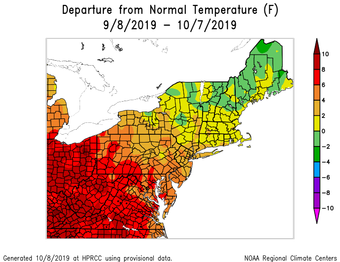
I was referring to October. Not since Labor Day. Any above normal in this pattern is solely because of skewed overnight lows in and around the city especially on cloudy nights Big difference in averages when you start pulling 68/60 rather than 68/48 just outside the city. You can throw whatever numbers you want out there but since the latter part of September, this has not been an above normal pattern outside the 11 million crammed heat island.
-
13 minutes ago, jfklganyc said:
They keep doing the smiley emoji at you...
But so far you have been spot on.
A few cool days. This week is masked by this storm...but it is 60 at 7am. Sat thru Wed all look AN.
Long story short, this cool stretch isnt that cool
You look at the small picture. Despite having the most population, the city is a small area with its own climate, especially at night. You go an hour outside the city (especially North and West) where it starts off in the 30s and 40s in most mornings now, the AN is bullshit.
-
1
-
-
6 hours ago, Sal Blandino said:
I actually am not happy about this possibilty of it getting active again. I'm a fan of prolonged dry tranquil strecthes with nothing but blue sunny skies and love droughts.
Seriously, are you 12 yrs old? If not, you have issues. You sign up for a weather board and complain about the use and discussion of weather models and while living in a city that is cold and gloomy 5 months a year, you bitch that all YOU wants is Arizona weather as far as the eye can see. You are lucky you don't post in the NE forum. They would've mocked you and sent your ass back to the Rock that you crawled out from under a few days ago. Advice.. If you don't like to hear about storms, don't go on a weather forum.
-
3
-
July 2023
in New York City Metro
Posted
Highland Falls is in huge trouble. Radar estimate of over 4” on top of the 10” from the other day and still coming down. This is surreal up here.
.