

snowwors2
-
Posts
1,551 -
Joined
-
Last visited
Content Type
Profiles
Blogs
Forums
American Weather
Media Demo
Store
Gallery
Posts posted by snowwors2
-
-
-
12 minutes ago, Ralph Wiggum said:
Yep, lowering my expectations here to 1-2" slop....snow showers and sleet showers, blech!!
...48 hours to go still Ralph‼️
-
-
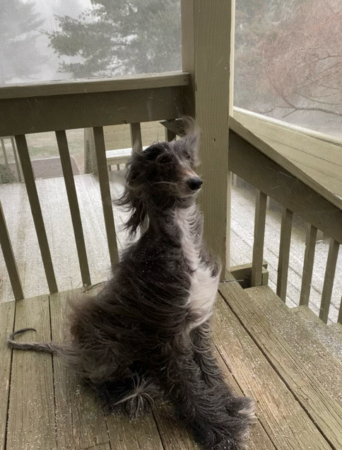
2 hours ago, Furrawn said:
Lovely snow squall a little after 11 a.m. today. The dog and I went out to play.
-
 2
2
-
-
2 hours ago, Stormfly said:
Is that with raincheck?
I had over 2.82 (!) yesterday according to the sensor, actual was 1.02" and now raincheck is showing .81".
Contact Tech support ASAP...
they are VERY responsive and will do a remote calibration for your device!!
-
1
-
-
46 minutes ago, RedSky said:
Ice on surfaces here what's up with that.
Ummm...frozen water!
")

-
 3
3
-
-
Larry Cosgrove shared a post: What a "Greenland block" means to you. See also: https://lnkd.in/gDgAvsT The weather pattern over North America during the next 5-6 weeks will likely be heavily influenced by a large blocking signature, a positive 500MB height anomaly commonly known as a Greenland Block. A symptom of a negative North Atlantic Oscillation, the persistent closed ridge complex can produce two noteworthy effects: 1) Keeping the incoming storm track suppressed toward lower latitudes in the USA, with strongest periods of disturbed weather off of the shoreline of the Mid-Atlantic and New England states and 2) enabling drainage of cold air from Canada into the lower 48 states. All of the numerical models have consistently shown ridging in the vicinity of Baffin Island/Greenland from the medium range (and in some cases) through the month of January. The analogs are also strongly favorable for this feature. If you look at forecast guidance, you see a trend of storms coming into the West Coast being diverted into Texas, then to Georgia, then slowing up along and off of the East Coast. It is a fairly classic scenario. The result? Heavier than normal precipitation in the eastern half of the U.S. Temperatures gradually trending below average after each storm.
-
1 hour ago, ChasingFlakes said:
I use a floodlight that is installed just beneath the peak of our roof. House faces due North/South, along with slope of roof, so my east facing bedroom window is underneath the light. Also I have a nice outdoor light at ground level beside a sliding glass door that works well. As long as the light is bright and close by, but not within direct view, you're good.
Edit: https://imgur.com/a/nNopVav
Why are my imgur posts not embedding, I swear they used to? I don't have anymore on-site storage.
My Ring floodlight cameras provide me 360° views around my entire home...
This one (facing NE) early Thursday am near the end of our recent snowstorm!
-
At the other end of the weather spectrum...
Towns in New England that were forecast to have several inches received several FEET instead (up to 4 feet in sections of New York, Vermont, New Hampshire and Maine)...
Even some 40”+ amounts in parts of north central PA‼️‼️
-
-
2 minutes ago, RedSky said:
I can imagine all kinds of things I can imagine if Margot Robbie and Dakota Fanning were my wives in my mormon harem but I have already done 10 and 12" in December this can be the one!
Well, they’ve probably “done 10 and 12” in December” too!
-
1
-
-
4 minutes ago, RedSky said:
Sorry 11" would be a debacle, 52 more years I ain't got. My bar is set at 16" with a range of 14-18"
Funny how our “snow” minds work...
Just imagine for one moment that all models, up until this run of the Euro, had us getting 1-3”....
Then we get this run of the Euro dishing out ~12” immediately NW of Philly...
Different reactions/emotions no doubt...
Expectations!!!
-
1 hour ago, Ralph Wiggum said:
RGEM is insane for SE PA. Epic banding. 24" lolli a few miles from me. Saving this map for archival purposes. Doubt that even comes close.

As in...
Buckingham, PA!!?
-
18z Gefs should make you feel better‼️
-
Wednesday night was supposed to be the show but I think most of you folks were under clouds⁉️
-
Easily mounted on shed with antenna mast and two mounting brackets from Amazon!
-
Ditto...
As I mentioned previously, I’ve had one for about a month now and love it!!! The rain is a bit high so far but they have a system where it adjusts about 24 hours later and with its AI it calibrates so within a couple of months apparently becomes increasingly accurate and will deliver forecasts specific to your back yard.
Amazingly cool system and they’re doing some type of BOGO now!
I’m waiting til the off the grid version is released to buy another one for my Maine home!
-
14 hours ago, tamarack said:
Some great hikes in that general area - Acadia to the west, Cutler coast to the east, Tunk and Black Mountains west of Cherryfield.
Thanks for the tips...
Settling on it in mid-November, I’ll be going crazy waiting til I can open it back up in April!
-
10 hours ago, ChescoPaWxman said:

I am so tempted to pick up that station....really looks interesting!
It’s very cool with great reviews and so simple...Reviews are outstanding!
The solar/cellular version won’t be available til Spring.
-
Think I’ve found my answer to a solar/cellular weather station (cool unit):
https://weatherflow.com/tempest-weather-system/
And...
Solar/cellular camera:
https://m.reolink.com/product/reolink-go-pt/?jumpId=faq-functions&triggerId=faq-data#overview
-
On 10/30/2020 at 6:55 AM, moneypitmike said:
Congrats on the new place! You must have really wanted to get away--Harrington's pretty far up there.
")
Thanks...
LOL...YEP...with the craziness of the world I figured why not really go for it if I’m going to Maine...Only about 1.5 hrs south of Canada!
-
1
-
-
On 10/27/2020 at 6:09 AM, KamuSnow said:
You'd have to spend a little bit, but what about a small (scalable perhaps) solar/battery system?
My answer to a solar/cellular weather station (cool unit):
https://weatherflow.com/tempest-weather-system/
And...
Solar/cellular camera:
https://m.reolink.com/product/reolink-go-pt/?jumpId=faq-functions&triggerId=faq-data#overview
-
11 hours ago, ChescoPaWxman said:
They are both the same Sunba IP PTZ camera model
Doesn’t look like they make a solar cellular version?
-
What’s your weather cam?


Jan. 31-Feb. 2 Miller B storm
in Philadelphia Region
Posted
It’s all simply guess work, hope and conjecture at this point folks...
Just let it play out...you’ll go crazy trying to figure it out from the numerical models prior to Saturday!