

Michigander
-
Posts
104 -
Joined
-
Last visited
Content Type
Profiles
Blogs
Forums
American Weather
Media Demo
Store
Gallery
Posts posted by Michigander
-
-
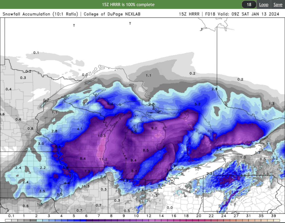
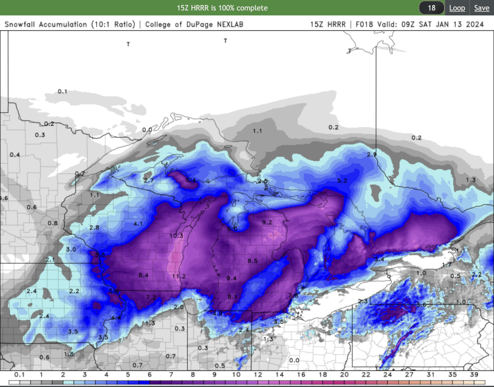
Looks like a dry slot running through mid and SE lower MI in the latest HRRR
-
 1
1
-
-
3 minutes ago, Imneversatisfied said:
Looking like I could be in for a historic blizzard here in Alpena. Atleast a foot and 50mph winds. A storm of my dreams! Going to prepare tomorrow. Idk what to even expect for drifts!
Enjoy it! Very surprised you don't have a blizz warning...
-
GRR went with a Winter Storm Warning but they did include guidance on lake effect in their AFD:
- Significant Lake Effect Snow Saturday Night into Sunday

As the winter storm pulls away from the region on Saturday, deep
moisture wrapping around the back side of the system and rapid
Arctic air advection into the region will set the stage for
impactful lake effect snow. The immediate transition to lake effect
snow will result in little to no ability to recover from the winter
storm impacting the region Friday into Saturday for at least the
western half of Lower Michigan.

Moisture depth for this lake effect event will be exceptionally high
at 25k ft deep along with significant lift through the DGZ,
occurring as 850mb temperatures crash to around -20C. Winds gusting
20-30 mph inland and around 40 mph at the coast will ensure areas of
blowing and drifting of the powdery lake effect snow. We are
expecting many of these impactful bands to push well inland across
the state given low level flow of 30-35 kts. The NAM12`s orientation
of lift in the DGZ combined with some surface wind convergence
occurring as cold air wraps around the southern portion of Lake
Michigan has the look of an I-96 to I-94 dominant band of snow and
blowing snow, prolonging treacherous travel conditions across
highways and interstates from Saturday night into Sunday afternoon.
This is in addition to significant snow showers and impacts up and
down the lakeshore region with no time to dig out from the outgoing
winter storm.

Model QPF over this 24-hr period (00z Sunday to 00z Monday) from the
ECMWF as well as the NAM12 is ranging from 0.25"-0.50", which with
snow ratios forecast to be 15:1 or a bit higher, would yield
snowfall amounts of 4"-8" with localized amounts around 1 foot near
and west of US 131. It should be stressed that accumulating snow
will spread further inland than most lake effect events, potentially
impacting areas such as Lansing with several inches.
-
GRR says they will issue updated headlines mid afternoon. Any chance of Blizzard warnings?
QuoteRegarding the winter storm watch, will look closely at new 12Z guidance and collaborate with adjacent offices before making final headline decisions. Updated headline decisions will come mid-afternoon.
-
8 minutes ago, WestMichigan said:
Not to interrupt the Chicago discussion but on the East side of Lake Michigan it is looking pretty good.
Yes indeed! We've had quite a few epic snow events recently. Had to cancel our ski trip to Boyne this weekend - don't want to drive or ski that wind. Might try for some nordic in the woods on Sunday or Monday.
-
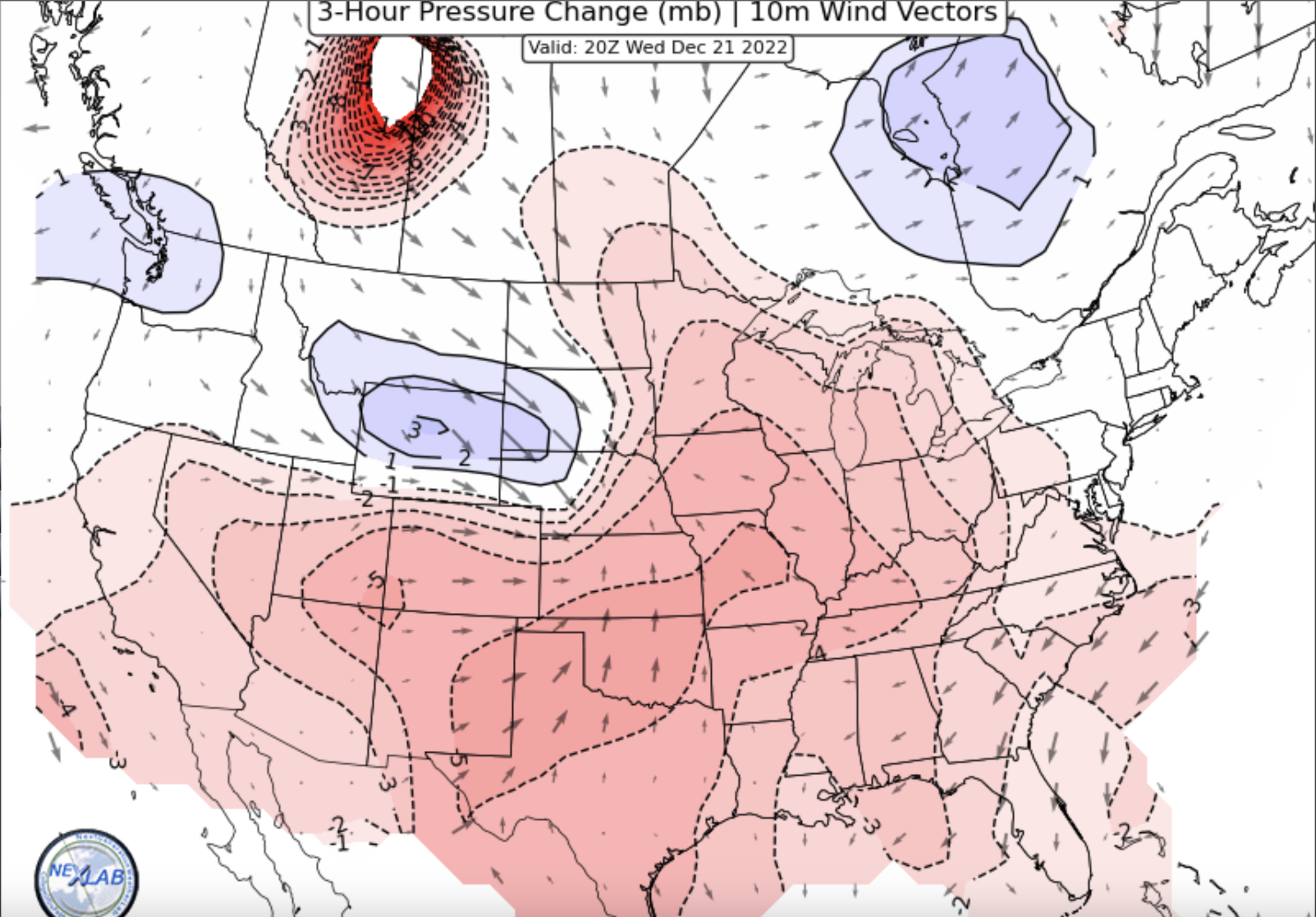
Though you all might find this interesting, apparently the HRRR was f'd up for two years due to a programmer error in setting the elevation of Lake Michigan:
https://www.woodtv.com/weather/ask-ellen/ask-ellen-did-years-of-forecasting-suffer-due-to-lake-mi-level-being-set-at-sea-level/ -
Merry Christmas from Grand Rapids
")
-
 8
8
-
 1
1
-
-
4 minutes ago, SolidIcewx said:
Wonder if DTX will upgrade. Winds over 50 still should be more then enough
I'm guessing no, if their reasoning is similar to GRR:
We have issued a Blizzard Warning for our western 2 rows of
counties and Winter Storm Warning for the eastern counties. This
storm as two significant aspects, the unusably strong winds
during a snow storm and the heavy snowfall, more enhanced lake
effect snowfall as the system moves away from the area. We issued
the Blizzard warning over our western counties for the combination
of heavy lake effect snow and strong winds. We went only with a
Winter Storm warning over the eastern counties since the snowfall
was less during the time of high winds, meaning it seems
questionable that we`d get the visibilities to stay below 1/4
mile for 3 consecutive hours.
-
-
GRR going with blizzard warnings for those of us on the west side
National Weather Service Grand Rapids MI
1217 PM EST Wed Dec 21 2022

LATEST UPDATE...
Update

.UPDATE...
Issued at 1217 PM EST Wed Dec 21 2022

After coordinating with nearby offices, we are planning to issue
a Winter Storm Warning for our eastern counties from Thursday
evening until Saturday morning (likely 7 am). For our western CWA
very likely we will issue a blizzard warning from Thursday evening
through Saturday afternoon.

The latest model trends over the past 3 runs of those model have
stopped backing off on QPF and continue to support the idea of
sustained winds in the 25 mph range with gusts to 40 mph on
Friday. So the reason to have a blizzard warning over the western
counties is that there would be significantly more snow during the
day on Friday to blow around then there would be over our eastern
counties.
-
 1
1
-
-
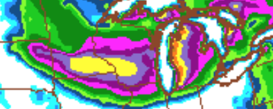
6 minutes ago, Harry Perry said:
Meanwhile
Kind of misleading that his screen shot represents less than half of the totals that the NAM actually shows through Saturday IMBY.
-
1
-
1
-
-
-
59 minutes ago, Chicago WX said:
Looking real good for MI. Good luck to you all!
Thinking a 1-2” call is solid for MBY. Anything more is gravy right now.

I seriously wish we could share some of this snow with you all. In my back yard we've gotten about 43" of lake effect already this year. My roof needs a break.
-
GRR from last night
Quote-- Growing concern for blizzard-like conditions Friday -- We continue to see impressive run-to-run model continuity in the depiction of the upcoming storm. As noted previously, Thursday`s precipitation type is a bit in question ahead of the main system. Given cold surface temperatures and strong lower tropospheric theta- e advection, freezing rain looks quite possible and even a bit more plausible than snow during the day and into evening. Ground temperatures might be able to warm above freezing by the afternoon commute but this is far from certain. Thus, a coating of glaze for the Thursday evening commute is a distinct possibility. Then, starting Thursday night, things get really interesting. In both the 18/12Z and 19/00Z runs of the ECE, a sizable majority of members show explosive cyclogenesis of a surface low originating from the mid-MS valley region and moving northeast into Lower MI or possibly eastern WI. Forecast deepening of the surface low Thursday night is unbelievable. The entire ensemble mean drops about 8 mb between 00Z and 06Z Friday and both the ECMWF and Canadian deterministic runs show a drop of 20 mb between 00Z and 12Z as the low center pulls into Lower MI. We continue to see evidence of a large TROWAL accompanying this explosive cyclogenesis. Copious snowfall associated with the TROWAL would likely be juxtaposed with very strong winds and apparent temperatures dropping into the single digits by early Friday afternoon. If this scenario were to pan out, we would be well into blizzard territory by Friday afternoon. This would be followed by a prolonged period of significant lake enhanced snow lasting most, if not all, of Christmas weekend. Obviously, a lot still can change between now and the end of the week. But, we have observed that the entire model suite has been extraordinarily consistent with this system, strongly suggesting greater than average predictability at this time range. The WPC cluster analyses seem more locked into a solution too. To illustrate, the 18/12Z WPC analysis showed cluster 1 alone explaining about 43 percent of the total ensemble spread and its membership is almost entirely ECMWF and Canadian ensemble members. This is not surprising given how much in lockstep these ensembles have been with this system in general. So, there is increased cause for concern, certainly more than there was at this time yesterday. Probabilities for a very impactful system at the end of the week into the holiday weekend are now uncomfortably high. Accordingly, now is the time to start thinking about preparing for this possible scenario.
-
1
-
-
7 minutes ago, Harry said:
Officially the total for yesterday is 12.6 which ranks as the snowiest day ever in the month of November. Previous was November 3rd 1966 with 9.5! And with them reporting 3.3 the day before it brings the official Les storm total to 15.9!
I knew there was gonna be a few higher totals here but that I didn't expect. My total is 13.0 so far. Ofcourse the observer is a few miles west of me on the Nw side of town.
Considering the break happening here this morning I kinda have mixed feelings about adding this afternoon/tonight's stuff to the event total. But yeah I know this is how multi day Les events roll. Officially need another 10.5 to break the Les total record which as mentioned before was with the Dec 2001 event which is 26.4! It stretched over 5 days..
The November snowfall records is 21 set in November 2000. Currently sit at 18.7 for the month so far. Had thought the record was a bit higher. Just checked though right before this post.
All in all impressive to say the least. Not Buffalo but impressive for here anyways. That Orchard Park total makes me feel like I got a dusting. Lol
Heavy snow again now in GRR, sending your way. Radar is lighting up.
-
1
-
-
5 minutes ago, jm1220 said:
I don't think it's considered landfall until much of the eye is ashore. But a noticeable tick east again.
The NHC called it landfall at Captiva, not me https://www.nhc.noaa.gov/text/refresh/MIATCUAT4+shtml/281557.shtml?
-
1
-
-
5 minutes ago, frostfern said:
Any other Grand Rapids are folks here? Looks like Lucy pulled the football away yet again. This winter has been so disappointing. It seems like it's just IMBY bad luck for GR in particular as other areas have been hit. At this point I'm ready for spring.
Yes my daughter is a senior in HS here in the GR area, and is very disturbed by the lack of snow days (none this year for our school district). It seems like October was the best month for winter weather. That said we took a ski trip to Boyne Highlands last week and got 6" of pow on Tuesday, which helped alleviate the pain..
-
1
-
-
1 hour ago, Toro99 said:
Can anyone who is more knowledgeable than me, explain why GRR went with an advisory versus a warning? Most models have a lot of their CWA receiving 6 inches or more in 12 hours tonight, and certainly 8 inches plus in 24 hours when the lake affect kicks in later on Saturday. Add that to the fact that this is going to be the most significant snow we’ve had all year, wouldn’t be prudent to go with a warning? Is it the timing of the snow, overnight? Or is it just GRR being GRR? Thanks in advance .
I was wondering the same thing. Mark Torregrossa from Mlive had a pretty good explanation here: https://www.mlive.com/weather/2020/01/winter-storm-warning-see-when-intense-snowfall-is-expected.html
-
49 minutes ago, Harry Perry said:
GRR staying with the advisory calling for a “general 4-8” with most of it falling by 10:00 am Saturday.
General? More “significant” when it’s not common for the current season or last for that matter haha.
Yes and remind me why this isn't a WSW? Clearly we could get 6" in 12 hours or less. It's amazing how they let recent history (last weekend's debacle) influence their judgement and tone.
-
1
-
 1
1
-
-
5 minutes ago, Aleksey said:
I am in GRR and I agree they should upgrade to WSW. All models point to 6-8" of heavy snow and some ice possible. Right now they are calling for 2-4" which I think is too low
They have been very stingy with their WSWs this year, except of course having them for a week straight during the vortex. IMO they totally blew it last week, when we had ice storms close down the city and force a state of emergency.
-
1
-
1
-
-
1 minute ago, HillsdaleMIWeather said:
IWX, GRR, DTX, and CLE considering Ice Storm Warning upgrades
Here's the latest update form GRR
.UPDATE...
Issued at 110 PM EST Mon Feb 11 2019

The forecast is generally on track, but we will make a couple
changes to the WSW. We will upgrade the northern zones to a Winter
Storm Warning for the expected impacts of 6 or more inches of
snow combined with winds gusting 35 to 40 mph at times. Expect
significant impacts to travel from blowing and drifting with near
whiteouts in open country roads beginning late tonight.

We will also move the start time of the advisory across the
southern zones to 7 pm this evening, as snow and mixed precip is
expected to be arriving there this evening.
-
Wind forecast for GRR looks brutal when the storm hits. Getting close to the B word.
-
1
-
-
5 minutes ago, Harry Perry said:
18z GFS definitely a “spread the wealth” for many.
Bordering on socialism
")
And thanks @UMB_WX for the Kuchera map. I hope the GRR office is watching these models.
-
1
-
 2
2
-
-
GRR is advertising 4-8" south of 96 in their AFD, yet my forecast (adjacent to the city of GR) is 8+, and we are well south of 96. Sh*t gets real when you include the lake effect totals by Thursday.
-
1
-


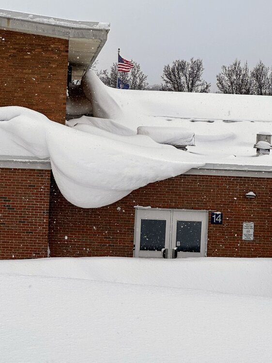
Jan 11-13th Blizzard
in Lakes/Ohio Valley
Posted
Don't lose hope - latest from GRR: