ValpoVike
-
Posts
644 -
Joined
-
Last visited
Content Type
Profiles
Blogs
Forums
American Weather
Media Demo
Store
Gallery
Everything posted by ValpoVike
-
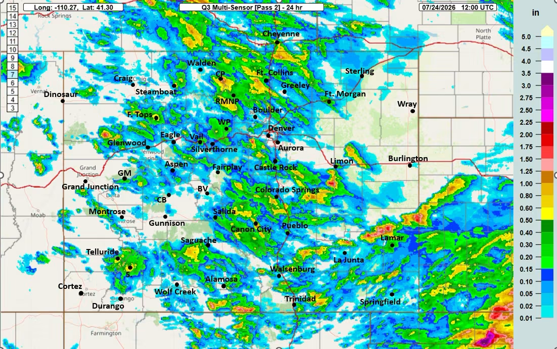
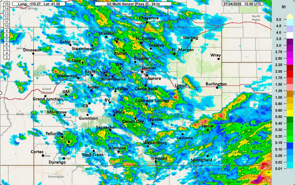
Flood warning for central Douglas county for up to 3" have already fallen. Congrats Smokey! Moving north to my backyard, we have a flood advisory. Picked up a very fast 0.60" and still coming. My July total just crossed 3", with >95% of that over the past 10 days.
-
Back building rapidly too.
-
You guys have some nice storms building from the SW. Be sure to unplug the force field projector.
-
I get both of your frustrations, and it seems like you have lived in a donut hole for the past couple of years. I was only responding to comments regarding the monsoon bust, which it clearly is not busting. Obviously, the SE metro begs to differ but that is more localized rather than indicative of the status of the region as a whole.
-
I just picked up 0.81” in under 40 minutes.
-
Usually the peak is late July thru most of August. There are also a lot of misconceptions about the monsoon. It typically affects the high country and occasionally storms push down into the plains.
-
Perhaps you should examine your expectations and not over-index on social or broadcast media. But even with that said I have noticed several Mets on social media being careful to say that not everyone will get rain on any particular day. Today a lot of people west of the metro would disagree with you. Except for Friday and partially Saturday, many locations have seen good precipitation. That goes for the past 2 weeks actually. Also, it is more of a pattern and not an event. The pattern allows storms to form on the western slopes.
-
I agree that this is pretty typical for Monsoon-time. The monsoon doesn't produce days and days of widespread heavy rain aside from a few lucky spots....but in years where it fails, it has severe consequences and it's absence has a remarkable effect. A big example is the 2020 "non-soon" which essentially created a summer of very low humidity + heat and that didn't end well.
-
-
For sure, northern front range did very well this week. Even Thornton did quite well. Sorry you guys didn’t.
-
I picked up 0.42" on Tuesday night about 30 minutes after the start of the dry lightning storm, and 0.80" on Wednesday. Today looks like a repeat of yesterday, so really pleased so far. After today, it looks like a couple of days of limited moisture up here then rain chances go up again Sunday thru most of next week.
-
Currently, we have the biggest dry lightning storm I have ever seen up here. Continuous ground to lightning, in every direction. It had better rain.
-
One thing comes immediately to mind, and that is criteria for Red Flag. One of the criteria for RF conditions is RH values roughly <20% along with wind and fuel conditions. Temp and dewpoint can vary, but as long as that criteria is met despite temp/dewpoint variations then the conditions meet one requirement for RF warnings.
-
I also had been missing out with storms going north and south of me, and mostly by a wide margin. However this morning we had a nice, gentle 3 hour rain. It only amounted to 0.19" but I'll take it.
-
The stratosphere has high ozone concentrations. My understanding is that in spring and early summer, intrusions are fairly common in mountain areas due to altitude. It also lowers RH substantially. Maybe a met can chime in with more details and some insight on the mechanics which I would love to understand.
-
May has been great for the drought in my area. Today's drought monitor shows D1/moderate drought conditions, down from D3/extreme just three weeks ago. I seem to recall that the data is collected on Tuesdays, and on Tuesday and Wednesday we had quite a bit of precip so it is possible that next week will continue to show improvement.
-
I am closing in on a 24 hour 1.0" total, and am extremely grateful that the temps are a bit higher than expected and therefore no accumulation. This is pushing my May total up close to 2.5" with significantly more forecasted thru the week. May is shaping up to be a drought buster for MBY fortunately.
-
Since Sunday afternoon thru overnight I have picked up 0.59”. About half of that from thunderstorms yesterday, and the rest thru snow showers early this morning. The temp is 35 degrees, and it will be interesting to see whether we get to the 4-5” of accumulation today. Regardless, it is good moisture.
-
Big time back off in the 12z GFS for the southern areas for sure, but the Larimer/Boulder foothills had essentially zero change. Around 16" for this area, while the 00z Euro shows 10-12", but I don't believe it at all unless this comes in colder. But the models have been trending colder for Monday, so we'll see.
-
May 17th/18th 2017. Something over 3 feet according to spotter reports. I didn't even bother trying to measure. The next day IIRC was about 70 degrees and it melted instantly LOL. But tree damage galore. My personal latest snow I've ever seen coming out of the sky was a long time ago (1997 or 1998 I think) when I lived in the Ohio snowbelt in Chardon, OH. I teed off on a round of golf in the morning during the first week of June with light snow falling.
-
For my location, both models are showing more snow than I care to see, and it has been consistent enough that I am starting to pay attention. I have a lot of trees and my cottonwoods are leafed out now. Rain would be fantastic…
-
Yeah, WTF. Yesterday morning, ECMWF was pretty bullish while the GFS was meh except for the mountains. They seemed to have reversed positions today. Who knows if we get snow, but good moisture looks more and more likely. I'm kind of cheering for rain rather than snow. That last storm was enough for me for the (extended) season.
-
I hope it is all gone by tomorrow. Snow in May is great moisture but it needs to go away LOL
-
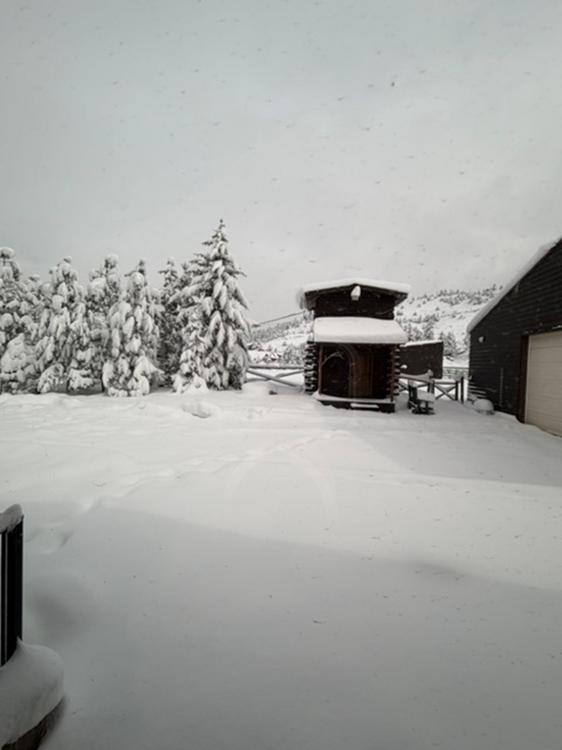
Here is a pic from my window this morning. Snow is too heavy for my Polaris Ranger to plow, so really hoping for some sun today.
-
After 3 swipes of the snowboard yesterday and today - final tally 19.5” here. Perhaps another inch coming this morning but it is winding down here. What a great storm.