
yankeex777
-
Posts
441 -
Joined
-
Last visited
Content Type
Profiles
Blogs
Forums
American Weather
Media Demo
Store
Gallery
Posts posted by yankeex777
-
-
Cause it hurts so good.
-
 2
2
-
-
59 minutes ago, RedSky said:
Sweet heat wave on the euro post storm for the moving on to spring crowd

Frankly im here for that. I miss golf
")
-
 1
1
-
-
1 hour ago, RedSky said:
Sun came out and popped to 32F, it burned off the snow on the grass and most surfaces the still low sun angle did not help me
Seriously the snow incinerated in less than half an hour like it was March

Same thing happened here. Why, exactly, does that happen?
-
 1
1
-
-
Just now, Nibor said:
I think areas away from the coast will have good ratios.
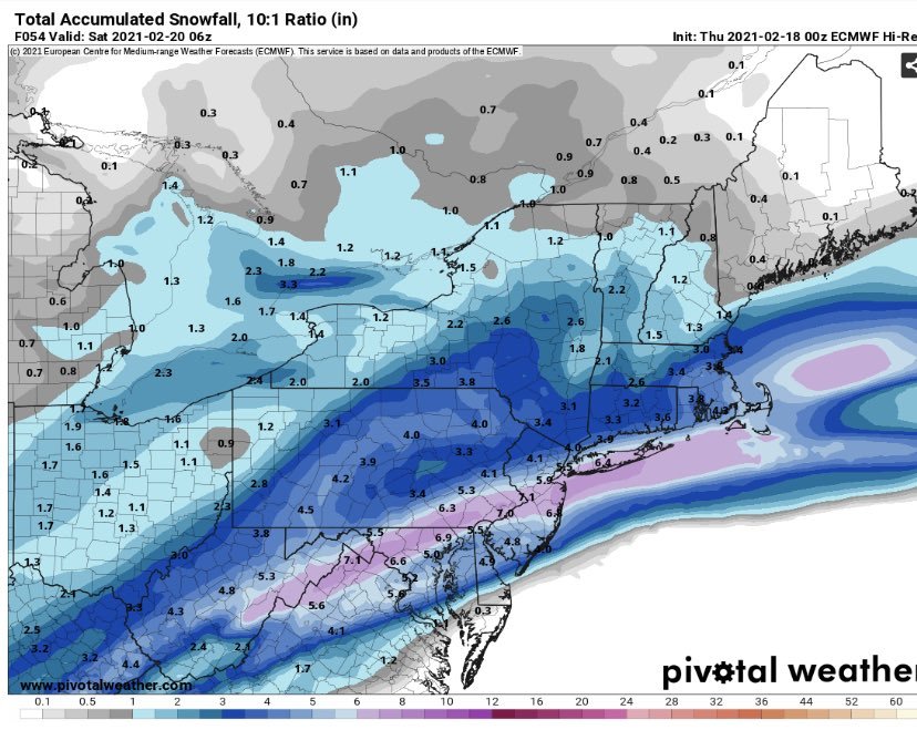
Perhaps, like ttn?
-
ggem has trended west from oz, few more shifts west and its basically in the gfs/euro camp
-
GGEM looks west of its prev. 0z run...
-
 1
1
-
-
19 minutes ago, LVblizzard said:
If you want some eye candy check out the 18z Euro ensembles and control run. Either it'll score a big coup or bust very badly.
Verdict?
-
1
-
-
15 minutes ago, The Iceman said:
GFS, while not as robust as 6z, still honking for 3-5" for most in SE PA into NJ. I like my call from earlier still, 2-4" region wide with lolli's of 6" wherever the best banding sets up. Won't be surprised if someone gets stuck in the screw zone though between the decaying shortwave and where the coastal takes over and only gets an inch. Think that should be a fairly narrow area though(knowing my luck that will run right along the delaware river though
 ) Looks like it will basically be a 6 hour storm for most with a hour or two of heavy snow between 09z-12z.
Whats the predicted start time for this one?
-
39 here in Hamilton nj. Dropping fast
-
First flakes in Hamilton, nj
-
15 minutes ago, Wentzadelphia said:
12z 3km/reg NAM bumped snow line SE again, 3km almost has 3-4invhes in NE philly
Can you share a map?
-
43 minutes ago, RedSky said:
Ralph's worried heard it here first that's 4-8" more in 7 days
Pretty much a certainty now.
-
1
-
-
I hear pings in Hamilton, nj right now.
-
5 minutes ago, hazwoper said:
CC shows the sleet line dropping south/holding steady
Can you link to that CC radar?
-
Very similar 90-10 ratio here in Hamilton. The snow got very fine
-
1
-
-
Just now, Snowcane21 said:
Yep. That band was incredible around 6 am. Heaviest rates of the season here. Parts of extreme lower bucks and eastern montco going to end up with 8-12”. If sleet holds off even more
I woke up while we were in that band, it was narrow but very heavy. Was not expecting but ill take it.
-
Absolutely ripping here in Hamilton. Big flakes. Heaviest of the season for sure. Could have 3 inches already
-
-
1
-
1
-
1
-
-
Just now, Snowcane21 said:
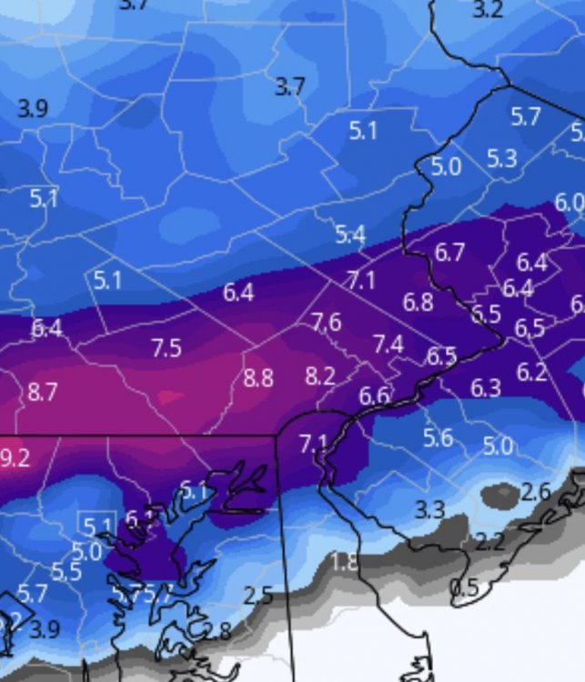
Agreed. This is The snow map off the NAM. NO sleet
Bless you sir, much better. Also, will take that all day
-
1
-
1
-
-
5 minutes ago, Snowcane21 said:
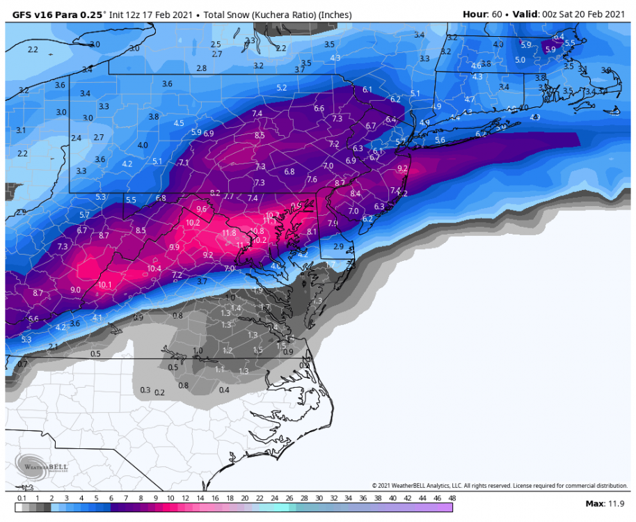
Yes it does. It says it right in the map. *includes Sleet*. Come on guys.
Right there is sleet on the map, south of the mason dixon line, but not in phl, not at 18z
But to be fair, im not a huge fan of their maps, especially when its not all snow
-
1
-
-
Just now, Moderately Unstable said:
My current call for the city is 4-7", including a fair amount of sleet, and .1-.2" of ice. This is based on a blend of the RPM and other model guidance. I don't buy all snow. RPM does show a consistent change to sleet and then FZRA on every run. How much the snow total ends up being hinges on how fast mid level warm air comes in...but we will enjoy at least a couple hours of good rates. And I will abs take that.
When do you think the best rates will hit?
-
1
-
-
6 minutes ago, The Iceman said:
Final call:
4-6" of snow and sleet along and west of 95 corridor up through 195. 8" lollipops somewhere in this area probably N and W where they don't flip.
2-4" snow/sleet/ possibly ending as light rain s and e of 95 and 195.
Should be a solid winter storm warning event still, 4th of the year, not too shabby.
I agree with this for the most part. I would say maybe 4-7 (less east, more west) from say rt130 west to just over the Delaware into PA. And that should cover most of mercer, some of Middlesex and north west burl county. If there's more sleet 4 inches will verify, less sleet than you could see that upper end amount and I agree with the lollys north and west especially if the sleet holds back.
-
Para looks good
-
2
-
-
NAM usually nails those sneaky warm levels, dont discount it


E PA/NJ/DE Winter 2023-2024 OBS/Discussion
in Philadelphia Region
Posted
TTN bullseye? Nah wont verify