

wisconsinwx
-
Posts
6,724 -
Joined
-
Last visited
Content Type
Profiles
Blogs
Forums
American Weather
Media Demo
Store
Gallery
Posts posted by wisconsinwx
-
-
Perked up right before the lake with a very solid garden variety storm. Tons of heavy rain and lightning, about 40mph gusts.
-
 2
2
-
-
Just now, SchaumburgStormer said:
#threadcancel
For the American posters you’re most likely right. I can’t speak for the Ontario folks.
-
1
-
-
43 minutes ago, A-L-E-K said:
strong llj really helping to sustain what remains of overnight MCS into N. IA right now but it should crap the bed here as the jet fades
We’ll see, definite signs the last half hour of disorganization but still tons of lightning with the MCS.
-
Extensive cloud debris and a sub severe complex in NE Iowa throwing doubt into today’s forecast. Even with that, still upper 70s already at 8am.
-
4 hours ago, madwx said:
suffice to say the HRRR was wrong about the path of the MCS tonight
More southward building than even I thought.
-
19 hours ago, Hoosier said:
The beaches have been packed though. Speaking of which, some of them are going to be closing. I guess too many people not observing proper distancing.
Ours are closing due to poor water quality/possible bacteria.
-
Not really the best day for MKE’s sensor to go out (it appears). We looked to be headed just short of 90F, but not sure. Would only be our 4th of the summer.
-
25 minutes ago, A-L-E-K said:
really like the idea of a linear MCS riding down the lake early sunday morning on the euro, hope it verifies
Would hopefully also dampen the extreme heat expected this weekend.
-
1
-
-
2 hours ago, madwx said:
New warning with the cell to the west. Tons of lightning with these things
20% chance of any rain overnight, yet the remains of this complex survived all the way to the lake. I'm thinking it's a positive feedback effect of all the rain we had last week; sure beats negative feedback we've had some years with drought developing in summer. Some house rattling thunder even.
-
23 hours ago, Angrysummons said:
I don't think a vaccine will matter as the rate of infection is likely to peter out by December.
Who knows at this point? We can all say we know the progression of COVID-19 over the next couple years but none of us do, only educated (and some uneducated) guesses.
-
2 hours ago, Baum said:
trending warmer it seems.
Certainly not this week, in fact through Thursday it's looking really seasonable for mid July. That certainly wasn't looking like the case last week when we were looking ahead to this one.
-
1 hour ago, fluoronium said:
Had some nice storms yesterday, nothing crazy but it brought some desperately needed rain (and lightning
 )
)
Received about 3/4" of rain which was more than the entire month of June here.
Where are you located? I took Champaign for instance and they received over 7" in June. Gradient is pretty stark clearly.
-
6 minutes ago, A-L-E-K said:
Feels like a ton of humidity just mixed out on real gusty south winds
What was your high today?
-
1 hour ago, RyanDe680 said:
When does the incoming threat for fire danger take hold?
I'm kind of wondering where that will be a problem? These ridges aren't exactly 2012 with dry frontal passages.
-
1
-
-
I think I count four different boundaries intersecting a little west of Milwaukee. Hard to say what the convection to the west will look like as it gets toward the lake.
-
 1
1
-
-
4 hours ago, frostfern said:
I think there will be SE diving ridge-rider MCS activity at some point. The problem with this stagnant pattern is the showers don't move very fast. They pop up in one location and rain themselves out, so instead of a 0.25" spread over a general area you get an inch falling over an area of a a few square miles and nothing nearby.
I notice a lot of little mesoscale micro-climates with a pattern like this here in Michigan due to slight terrain differences. Storms like to pop up near Jackson and Ann Arbor because there's a slight ridge there. There also some pretty high terrain west of Cadillac in the northern lower peninsula that's been getting showers almost every day. Low areas and areas too close to bodies of water miss most of the time.
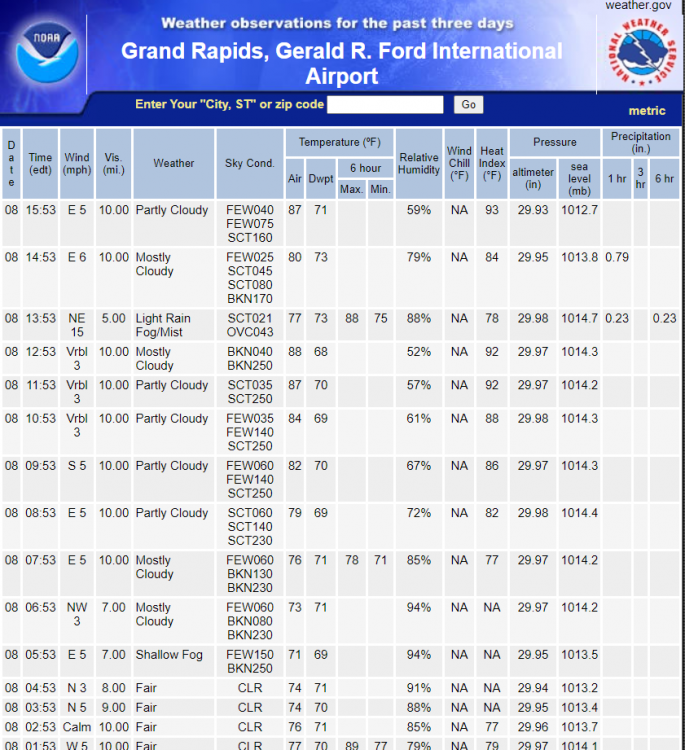
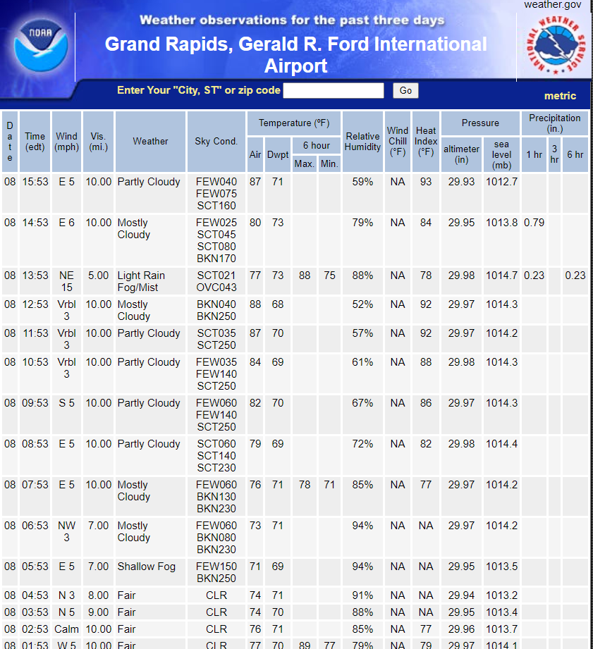
Your lawn must be getting a good drink today; I see a 2nd thunderstorm has just taken aim on Grand Rapids today.
-
22 minutes ago, frostfern said:
I think there will be SE diving ridge-rider MCS activity at some point. The problem with this stagnant pattern is the showers don't move very fast. They pop up in one location and rain themselves out, so instead of a 0.25" spread over a general area you get an inch falling over an area of a a few square miles and nothing nearby.
I notice a lot of little mesoscale micro-climates with a pattern like this here in Michigan due to slight terrain differences. Storms like to pop up near Jackson and Ann Arbor because there's a slight ridge there. There also some pretty high terrain west of Cadillac in the northern lower peninsula that's been getting showers almost every day. Low areas and areas too close to bodies of water miss most of the time.
In this pattern this week it’s uncanny how the biggest pop ups tend to be near major cities.
-
35 minutes ago, madwx said:
Saturday looking potentially interesting in Wisconsin on the NAM and 3km NAM.
Haven't had many NW flow setups yet, but this could easily be a decent one.
-
Milwaukee was 89’d today (only got up to about 86F at my place) so no official heat wave with this first spurt of mid summer heat (only 2 days of 90s in a row and 3 on the year).
-
5 hours ago, frostfern said:
Yea. We got some of those in late May this year. When there was easterly flow during the blocking pattern there just wasn't enough moisture for anything to pop up.
No easterly, but today winds were virtually calm and a pulse shower (no thunder) due to the lake breeze dropped an inch of rain at the airport. I'm only 3 miles away and there wasn't enough to completely wet the pavement. It just sprinkled a few huge drops of rain. With dewpoint near or above 70 showers that form are super efficient precip-generators. The problem is they form in one random place and don't move.
Yeah we got a quick downpour like that in the Milwaukee area today too, 5 miles away it looks like they had a quick quarter inch in about 15 mins and not a drop here. Luckily we don’t desperately need rain at this point.
-
On 7/7/2020 at 6:10 PM, Jonger said:
Arizona, Texas, Florida and California still aren't putting up numbers worthy of a freak-out.
This thing is either weaker or doctors know how to handle it. Great news for opening up the country before the end of the summer.
The case numbers are worthy of a freak out, but most of the rest of the states' numbers aren't worthy of a freakout..at this time.
-
It looks like even our brief cooldown will still have peak temp/dew point figures above 80/60. That's about average, going to be pretty weird not to have any decent July breaks from the heat, at least in the first half of the month.
-
48 minutes ago, frostfern said:
Yea. The rex-block really dried out the eastern great lakes. The block has finally broken down, but the jet is still too far north to propel any Wisconsin MCS into the Great Lakes. Light westerlies with little shear and no nocturnal low-level jet is a dry pattern for me.
Do you ever get the inverse of lake breeze thunderstorms, at least for counties adjacent to the lake? In your case it would be light easterly winds (or similar component) giving way to west winds off the lake.
-
1 minute ago, dmc76 said:
What does a shot of afternoon storms have to with the west being dryer than the East?
Western Lower Michigan seemed to do decently with storms in May and June, but this July pattern and lake shadow appearance looks to do them little favors. I guess this persistent ridge and common SE/E flow is the main culprit.
Coronavirus
in Lakes/Ohio Valley
Posted
Interesting, I was watching his tournament today and must have been away at the time because I did not catch that. Did he say what month he thought it was?