

Calderon
-
Posts
1,132 -
Joined
-
Last visited
Content Type
Profiles
Blogs
Forums
American Weather
Media Demo
Store
Gallery
Posts posted by Calderon
-
-
21 minutes ago, DLMKA said:
LSX radar down for maintenance with two tor warned cells in the metro.
It's back in service as of early afternoon, it's good data now.
-
It's the Campbell Road substation practically exploding from the oil inside transformers.
-
 3
3
-
 1
1
-
-
Some of the exact same areas hit by the F3 in 2006 are hit again in Gallatin, just now including the airport.
-
Quote
..TORNADO EMERGENCY FOR GALLATIN AND HENDERSONVILLE...
...A TORNADO WARNING REMAINS IN EFFECT UNTIL 515 PM CST FOR
NORTHEASTERN DAVIDSON...SOUTHERN SUMNER AND NORTHWESTERN WILSON
COUNTIES...
At 452 PM CST, a confirmed large and destructive tornado was located
over Hendersonville, or 10 miles southwest of Gallatin, moving east
at 40 mph. -
It's going to hit the DuPont Plant, if not within a half mile.
And less than 2 miles north of the NWS.
-
Exactly, it's nowhere in the warning text. It has this pulsing polygon with it when you click on it but warning text says otherwise.
No issues on the MacBook app like that.
-
2 minutes ago, TellicoWx said:
2nd Tornado Emergency..north of the 1st one
There isn't one in effect. RadarScope is having some weird problem on cell phone apps.
-
Another now confirmed south of Springfield, TN.
-
1
-
-
New confirmed tornado in northern Dickson with a healthy CC drop east of Slayden.
-
1
-
-
It's a shame here in SAT because we were off & running to a great start and then it just went "poof" last month.
-
 1
1
-
-
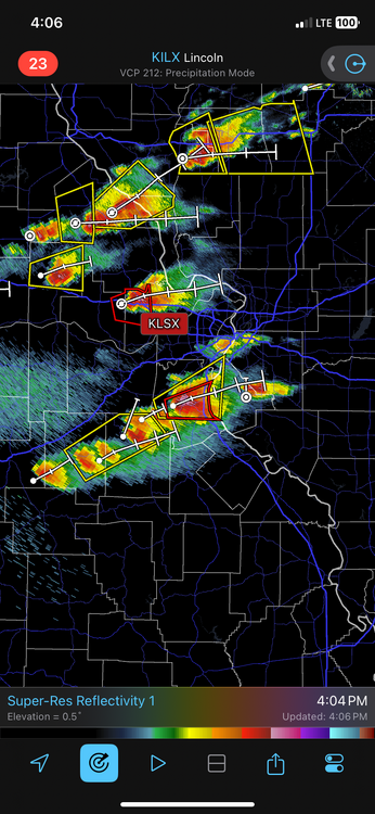
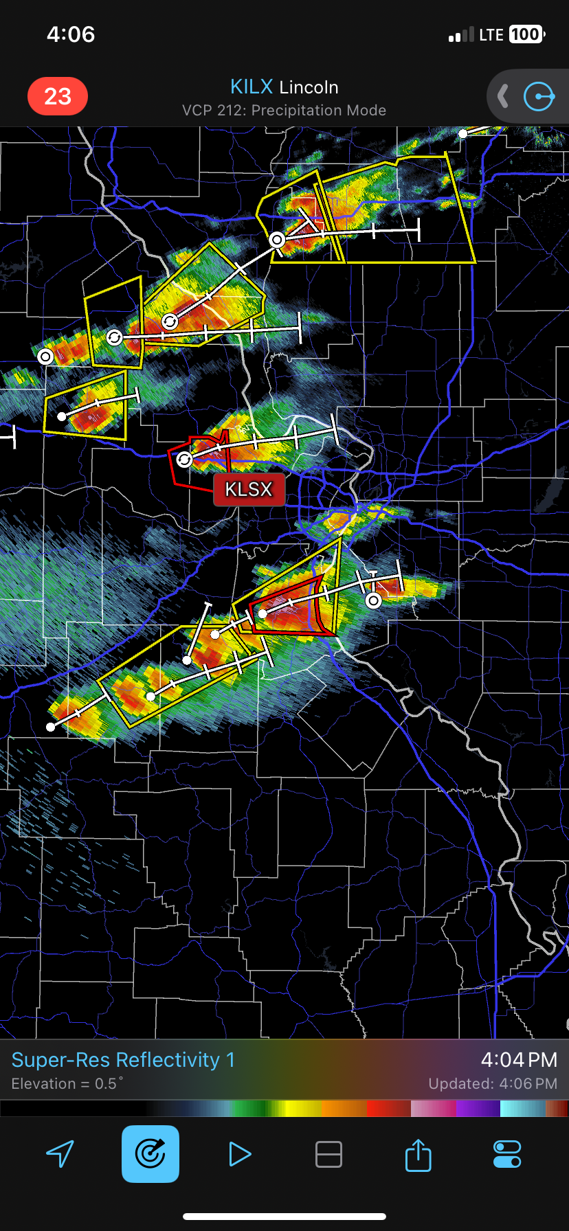
Confirmed tornado in St. Louis County, MO near Valley Park.
-
2
-
-
So far, the combined path of the EF3 in southern TN is at 86 miles, likely a new state record for path length. It still could potentially be longer given preliminary data.
-
Intense tornado now between Murfreesboro and Woodbury over Readyville. Mostly rural between the two.
-
Tornado Warning for...
Southern Rutherford County in Middle Tennessee...
Northwestern Bedford County in Middle Tennessee...
Southwestern Cannon County in Middle Tennessee...* Until 200 AM CDT.
* At 127 AM CDT, a tornado producing storm was located 15 miles
southwest of Murfreesboro, moving east at 55 mph.HAZARD...Damaging tornado.
SOURCE...Radar confirmed tornado.
-
Touchdown is imminent near Eagleville, TN.
Edit: Huge CC drop just north of Unionville as of 128am.
-
Eh, circulation really became elongated and occluded to the north. Columbia likely dodged a bullet.
-
Long-tracker is still on the ground in Middle Tennessee. Likely been on the ground over an hour and across 4 counties. Now approaching the southernmost exurbs of Nashville.
-
Tornado still going, now near Hohenwald in Lewis County.
Also, spin-up trying near Hendersonville.
-
1
-
-
Just now, cheese007 said:
Yet another tor warning east of Nasvhille
West
It's Dickson & Cheatham Counties, and aimed right towards downtown.
-
Huge hail in Metro East part of St. Louis in Monroe & St. Clair Counties, including where I used to live in Shiloh. Widespread golf balls and some larger.
-
The Covington storm, if it sustains, will ride I-40 up into Nashville in a few hours. I see no reason for it not to hold its own.
-
>150mph GTG on southeast side of Covington.
-
 1
1
-
-
Potentially violent tornado on the south side of Covington, TN. Most of the city is south of downtown and this is really, really bad.
-
Going to be interesting with interaction and a merger probable between the two TOR warned cells southwest of STL. I'm much more concerned for areas roughly from Edwardsville, to Valley Park, to Pacific, and points east of there, including downtown and the Metro East (Scott AFB).
-
1
-
Severe Weather 3-13 through 3-16-24
in Central/Western States
Posted
Tornado in progress southwest of Little Rock in Hot Springs Village with reports of numerous homes damaged.