

Baroclinic Zone
-
Posts
46,273 -
Joined
-
Last visited
Content Type
Profiles
Blogs
Forums
American Weather
Media Demo
Store
Gallery
Posts posted by Baroclinic Zone
-
-
3 hours ago, CoastalWx said:
6.4” should do it.
This is what you get when you piss off the rain gods. Congrats.
-
 1
1
-
-
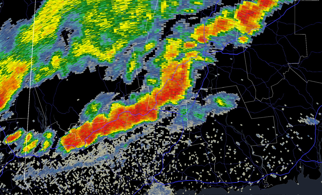
Wild night.
1.44” per radar-
 2
2
-
-
12 hours ago, Damage In Tolland said:
I don’t buy all these hi res models blowing up storms tonight.
Nice call…

-
2
-
 1
1
-
-
4 minutes ago, CoastalWx said:
I'll sell 98
I’ll take 96F
-
2
-
-
2 hours ago, butterfish55 said:
93/77 in this neck of the woods.
BRUTAL, but I love it. As an electrician, I work inside and outside all year round. I much prefer a day like today over frigid cold in the winter. But that's just me98F!
-
1
-
-
Early rains prevented another 90 day. Topped out at 86. Dews are around 80.
-
2
-
-
5 minutes ago, dendrite said:
Min 67.3°
Should be high 80s here again with more low 90s in the warm spots.
Low of 68 here, has already rebounded to 76.
-
2
-
-
5 minutes ago, HoarfrostHubb said:
Didn’t you have a pretty sweet Davis set up?
I did. It’s in storage.
-
1
-
-
40 minutes ago, kdxken said:
Better change your airport code. The one you're using now isn't even close. (Said in a pleasant manner).

That’s the closest ASOS to me
-
2
-
-
Hi of 99F
suck it acatt
-
1
-
2
-
 2
2
-
-
Topped out at 94F
-
1
-
-
-
-
-
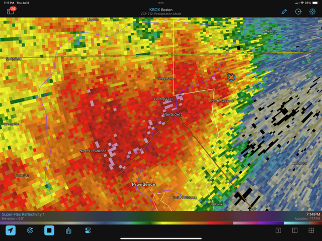
Outflow just came thru
-
Flashes and thunder here even with storms a distance away
-
1
-
-
Looks like a rough I-84 drive right now.

-
1 minute ago, CoastalWx said:
You seem to run high?
 Not my station. It’s about 1/4mi up street.
https://www.wunderground.com/dashboard/pws/KMAATTLE150/graph/2025-07-1/2025-07-1/daily
I haven’t been able to find/see where the station is set up.
-
1
-
-
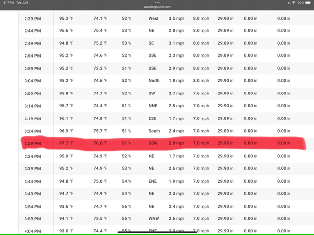
94/75 at peak.
Just before 4pm90s are the daily now
-
1
-
-
8 hours ago, bristolri_wx said:
-
3
-
 1
1
-
-
91 here
11 days this month
-
3
-
-
Hovering at 90F.
-
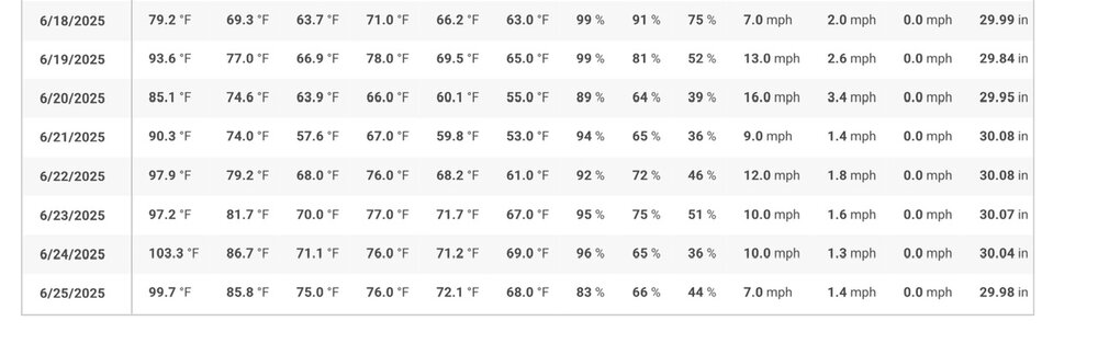
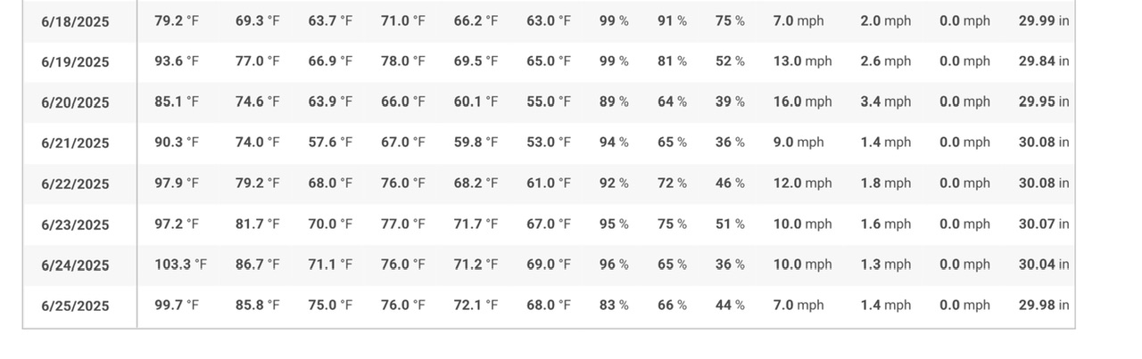
99.7F for high. Legit heat for 4 days.
-
13 minutes ago, dendrite said:
The dew here is just as bad as yesterday at this time. Stuck between 76-78 on the Davis.
Same here. HX are around 111-112

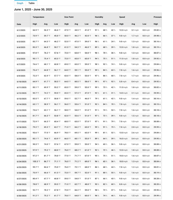
July 2025 Obs/Disco ... possible historic month for heat
in New England
Posted
Dews dropped in this afternoon. Applied a roll to each cheek.