

Doorman
-
Posts
1,582 -
Joined
-
Last visited
Content Type
Profiles
Blogs
Forums
American Weather
Media Demo
Store
Gallery
Posts posted by Doorman
-
-
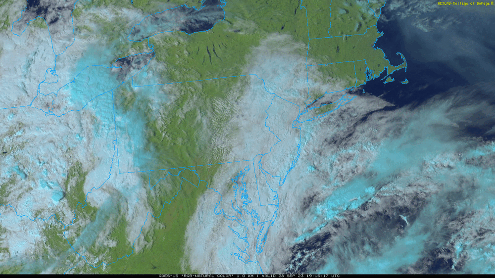
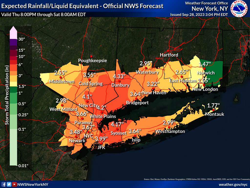
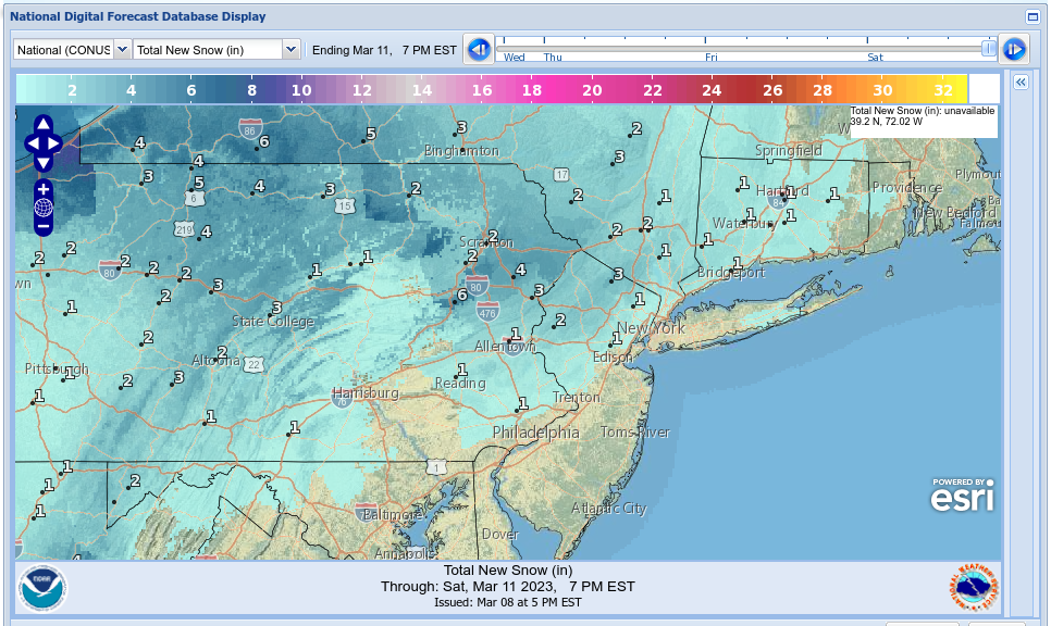
Excessive Rainfall Discussion
NWS Weather Prediction Center College Park MD
1154 AM EDT Thu Sep 28 2023
Day 1
Valid 16Z Thu Sep 28 2023 - 12Z Fri Sep 29 2023
...A SLIGHT RISK OF EXCESSIVE RAINFALL IS IN EFFECT OVER PORTIONS
OF THE MID-ATLANTIC AND NORTHEAST...
...16Z Update...
In coordination with the local WFO offices in Mount Holly and
Upton, have upgraded the D1 ERO to a Slight Risk given the trends
in short term guidance in terms of placement and magnitude of
heavy rainfall this evening. General synoptic scale pattern
remains fairly similar to previous forecast package, but more
emphasis on heavy rain potential has arose given the signals on
the latest ensemble means and deterministic QPF distribution. 12z
HREF neighborhood probabilities of >1" and >2" totals across
northern and central NJ, as well as the NYC metro into the
southern Catskills was sufficient to upgrade the area to the SLGT
risk. There is still some discrepancy on the exact placement of
the heaviest QPF footprint, however the highly anomalous u-vector
wind fields across northern NJ and adjacent areas are all
prevalent across all guidance which would generate a robust
upslope component typically found in these types of heavy rain
events. Convective potential is still on the low side, but
non-zero given the theta-E advection regime likely overnight into
early tomorrow morning as indicated by all deterministic, global
or hi-res base. Total QPF between 1-2" with locally as high as 4"
are being depicted within the HREF blended mean QPF which only
lends credence to the higher potential with the SLGT. Main areas
of concern will be the higher terrain in NNJ and southern NY
state, as well as the urban areas in-of NYC/Newark/Jersey City.https://www.wpc.ncep.noaa.gov/index.shtml#page=ero
-
 2
2
-
-
-
right click on the link below for sat loop ....

-
1
-
-
-
https://www.wpc.ncep.noaa.gov/discussions/hpcdiscussions.php?disc=qpfhsd
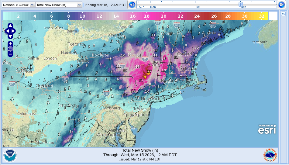
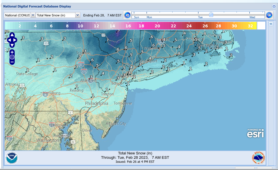
WPC disco
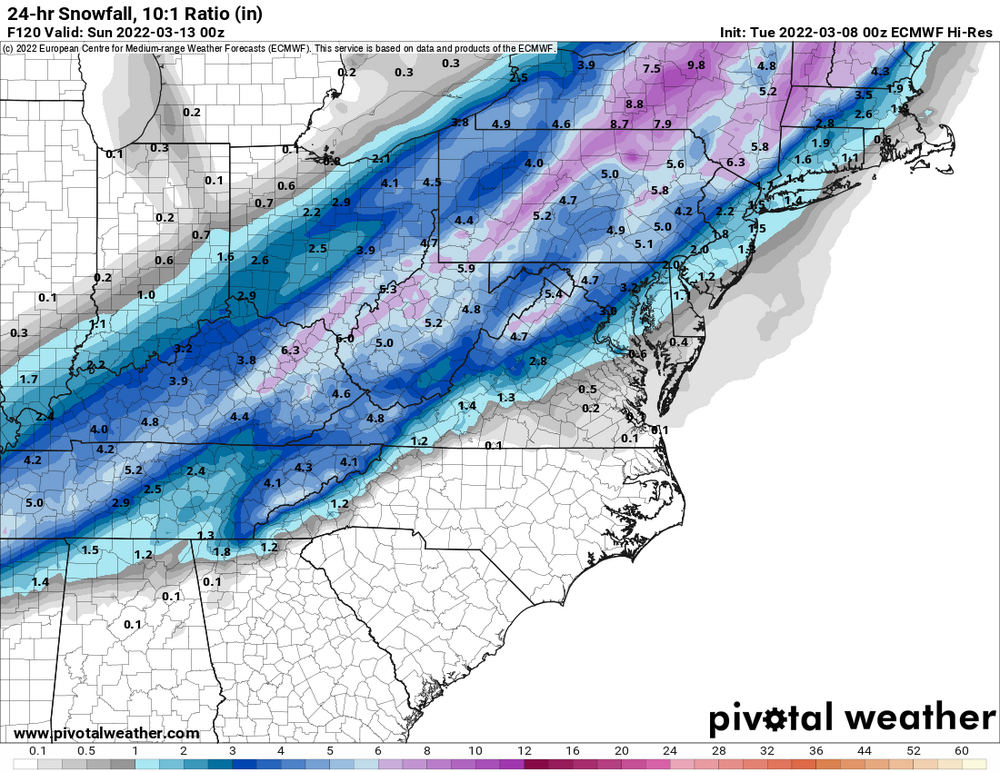
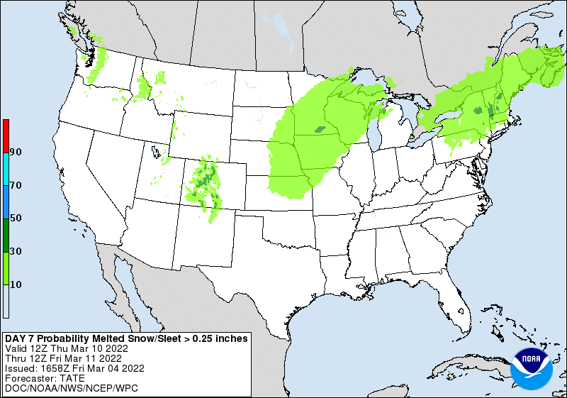
Probabilistic Heavy Snow and Icing Discussion
NWS Weather Prediction Center College Park MD
402 PM EDT Sun Mar 12 2023Valid 00Z Mon Mar 13 2023 - 00Z Thu Mar 16 2023
The heaviest snow will likely occur in the interior northeast
terrain including the Adirondacks, Catskills, Greens, Berkshires,
Worcester Hills, Monadnocks, and Whites where WPC probabilities
for 6 inches are above 80% on D2, and reach 50-80% for 12 inches
in these same areas. In the valleys, snow totals will likely be
less, but intense ascent could still prevent extreme shadowing on
the e/ne flow, and WPC probabilities for 6+ inches are above 50%
even in the lower elevations all the way up the coast of Maine
despite that area being impinged upon by drier air and being more
removed from the low center as it moves east instead of northeast
late. For the I-95 corridor, there is good potential for a period
of heavy snow to develop on the back side of the system near the
coastal front, and while WPC probabilities for NY to Boston are
pretty low for 2-4 inches, the guidance has trended a bit more
aggressively for this area, and there are several members in the
WSE plumes that suggest heavy accumulations even to the coast.
While confidence in major impacts and heavy snow accumulations is
greatest inland across the higher terrain, the potential still
exists for a significant snowstorm for NYC to Boston as well.THE DARTBOARD

-
2
-
-
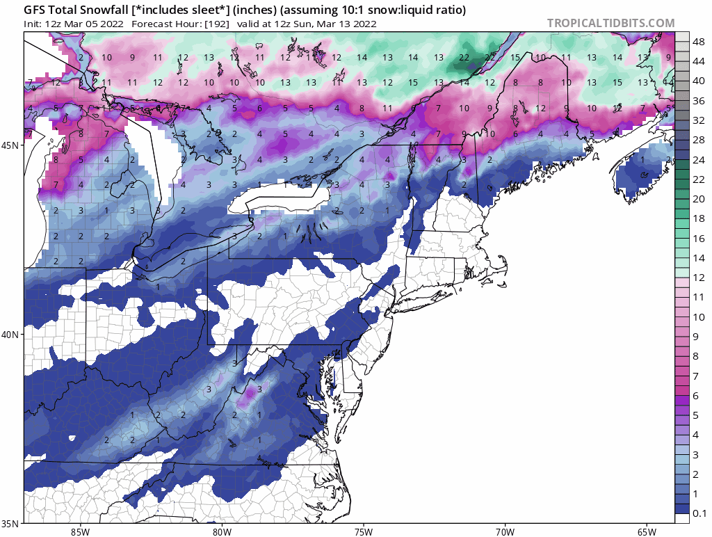
even if it isn't in your backyard.....
those red colors (totals)
still have to grab at ya, in the month of March
-
42 minutes ago, WestBabylonWeather said:
So what’s going on with liberty be…..I mean this storm next week?
12 minutes ago, David-LI said:Anyone have any info on the 18z euro?
SOGGY

-
-
-
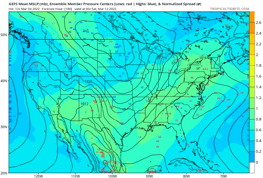
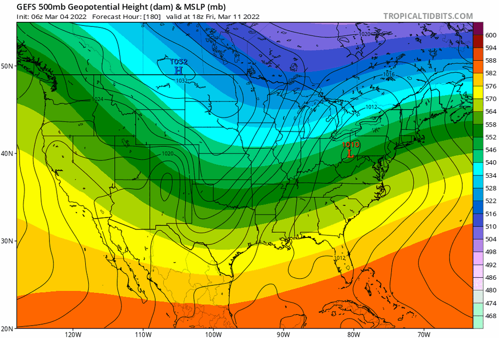
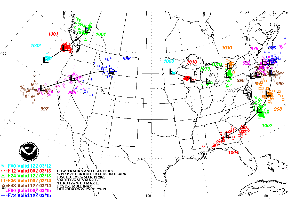
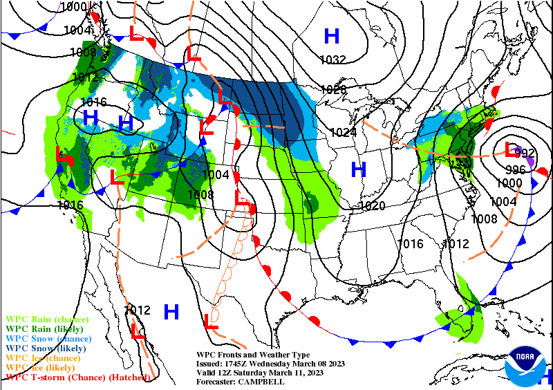
Upton NWS disco


LONG TERM /THURSDAY THROUGH MONDAY/...
No changes were made to the long term forecast Thursday through next
Monday.

Another piece of PAC energy sets its eyes on the area late in the
week into the weekend. The operational global models are in very
good agreement in taking this energy and closing off an upper low in
the vicinity of the the Northern Plains and/or Upper Midwest
Thursday night into Friday, then diving the system ESE and off the
Mid Atlantic coast Saturday. This will allow for a secondary low to
form along the coast as the upper forcing approaches. Greatest
uncertainty lies where the secondary forms. GEFs is the northernmost
of the ensemble means and has good clustering just south of Long
Island, however, the EPS and GEPs means are much farther south and
also support their operations runs. NBM wind field, which was
closely followed, reflects a track south of the forecast area.

Like so many southern branch systems this year, the track and lack
of available cold air, has resulted more often in liquid than frozen
precipitation events. This event is no different. In addition,
unlike the last 2 systems, there is no block across eastern Canada
with cold air source bleeding cold air south across New England.
Thus, this looks to be a mainly rain event with a rain/snow mix
possible on the backside Saturday night.

Prior to that time, offshore low pressure and a northerly flow from
eastern Canada into New England will result in temperatures near
normal with highs in the 40s and lows in the 20s inland and 30s at
the coast. High pressure to the west slowly builds into Thursday
until weakening and moving offshore Friday ahead of the
aforementioned coastal low. While it will still be breezy on
Thursday, gusts should be weaker than Tuesday and Wednesday,
generally 20-25 mph. Winds weaken further for Friday with high
pressure over the area. Over the weekend, temperatures will depend
on the exact track of the low, but subtle departures are forecast
from the mid week period.

It should be noted that NBM probabilities for seeing greater than 1
inch of liquid equivalent in 24h for the potential weekend system
have held fallen a bit to 15 to 30 percent percent. For 2 inches, it
remains generally under 5 percent.
-
 1
1
-
-
-

-
2
-
 2
2
-
 6
6
-
-
COD MET meso-floater
small scan mode
https://weather.cod.edu/satrad/?parms=meso-meso1-02-96-1-100-1&checked=map&colorbar=undefined
-
-
-
1 minute ago, EastonSN+ said:
Could be a decent hit for the western 1/3 rd of our forum.
happy tracking
-
1
-
1
-
-
On 3/4/2022 at 1:55 PM, SnoSki14 said:
The Atlantic blocking & +PNA shown was just a headfake and transitory. Also I'm not sure what Doorman is smoking. How will that lead to a coastal track exactly?

-
1
-
-
keep hope alive......


-
1
-
2
-
-
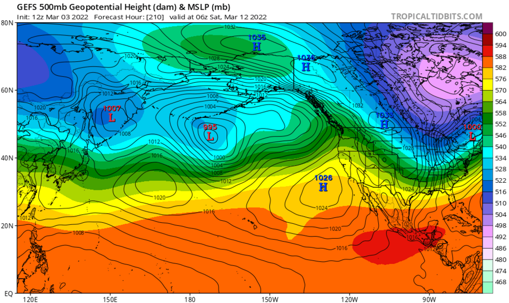
 Benchmark .....get ready for a fun week of tracking
-
2
-
1
-
-
 from cutter to coastal....just like that
We will snow next weekend !!!!
-
3
-
 1
1
-
1
-
-
Weenie Breakfast


-
1
-
1
-
-
stay tuned.....
")
-
1
-
-
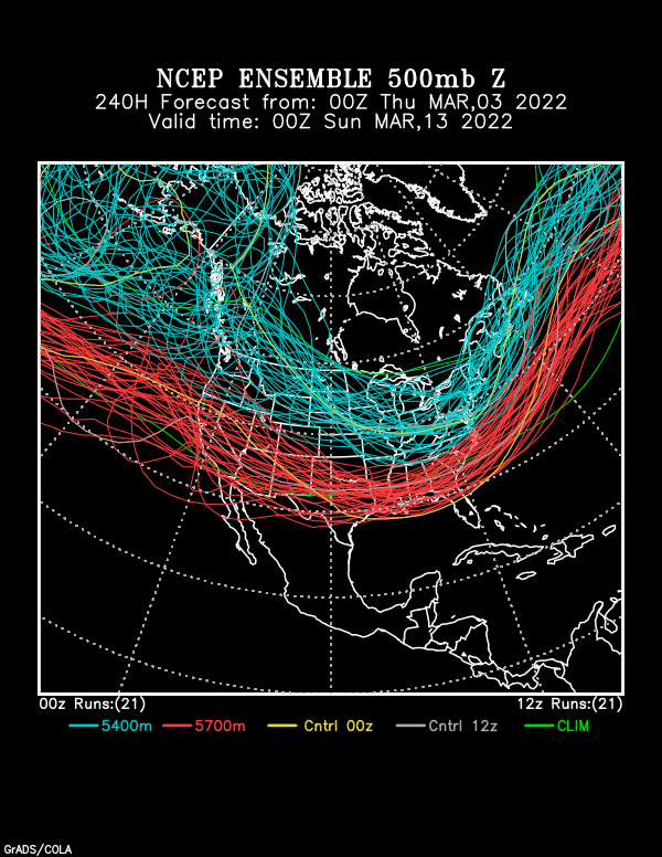
1 hour ago, bluewave said:
The 12z Euro is on steroids with a cutter dropping to 940mb in SE Canada day 10.

love the signal for a big-time event
---------
Textbook -EPO from the 12z GEFS adds to our weenie fuel supply

-
1
-
1
-
-
10 days out.......but here we go
in the words of Mr. MC Hammer--- this threat is......
"too legit to quit"

-
4
-
 2
2
-
1
-


Snow Friday 1/19/24: is it a period of light snow (less than 2"), or is there a chance of a 5" swath in part of the NYC subforum? Event OBS.
in New York City Metro
Posted
https://www.wpc.ncep.noaa.gov/discussions/hpcdiscussions.php?disc=qpfhsd
WPC disco
...Ohio Valley, Mid-Atlantic, Northeast...
Day 3...
A fast moving shortwave dropping southeast upstream of the broad
trough across the eastern CONUS will amplify as it shifts towards
the Ohio Valley Friday morning, and then maintain its amplitude
during its trajectory eastward across the Mid-Atlantic. The flow
is fast, and the shortwave is of modest intensity, but it will be
efficiently topped by a potent 170+kt jet streak diving through
the trough to enhance deep layer ascent. At the same time, a cold
front will be making its way eastward from the Great Lakes to the
Mid-Atlantic states, and it is possible the associated fgen along
this front could be enhanced by the upper jet streak pivoting
overhead. This will likely enhance ascent and will result in a
surface low pressure developing near the Carolinas and then racing
east-northeast into Saturday /D4/. PWs downstream of the best
ascent are expected to be modest within the generally zonal and
fast flow, although some enhancement towards +1 sigma may surge
northward into VA as reflected by the NAEFS ensemble tables, but
this will likely be dependent on the intensity of the surface low
to drive more robust theta-e advection northward. The GFS/ECMWF
and their associated ensemble clusters have trended weaker/farther
southeast today, but the CMC and its ensemble remain more intense
and closer to the coast. The threat for heavy snow appears to be a
little lower than from previous model cycles, but uncertainty is
still high, and regional soundings indicate support for high SLR
snow due to a cold column and SREF DGZ depth probabilities for
100mb reaching 10-30%. WPC probabilities for more than 4 inches of
snow on D3 are modest but expansive, reaching 10-30% in a
west-to-east oriented swath from eastern Indiana through Long
Island, although probabilities have decreased today. The exception
is along the WV Appalachians where colder temperatures and some
upslope flow should result in efficient snowfall accumulations,
and WPC probabilities for 4+ inches are above 50% in this area.
OPC 72hr prog