

Joe4alb
-
Posts
529 -
Joined
-
Last visited
Content Type
Profiles
Blogs
Forums
American Weather
Media Demo
Store
Gallery
Posts posted by Joe4alb
-
-
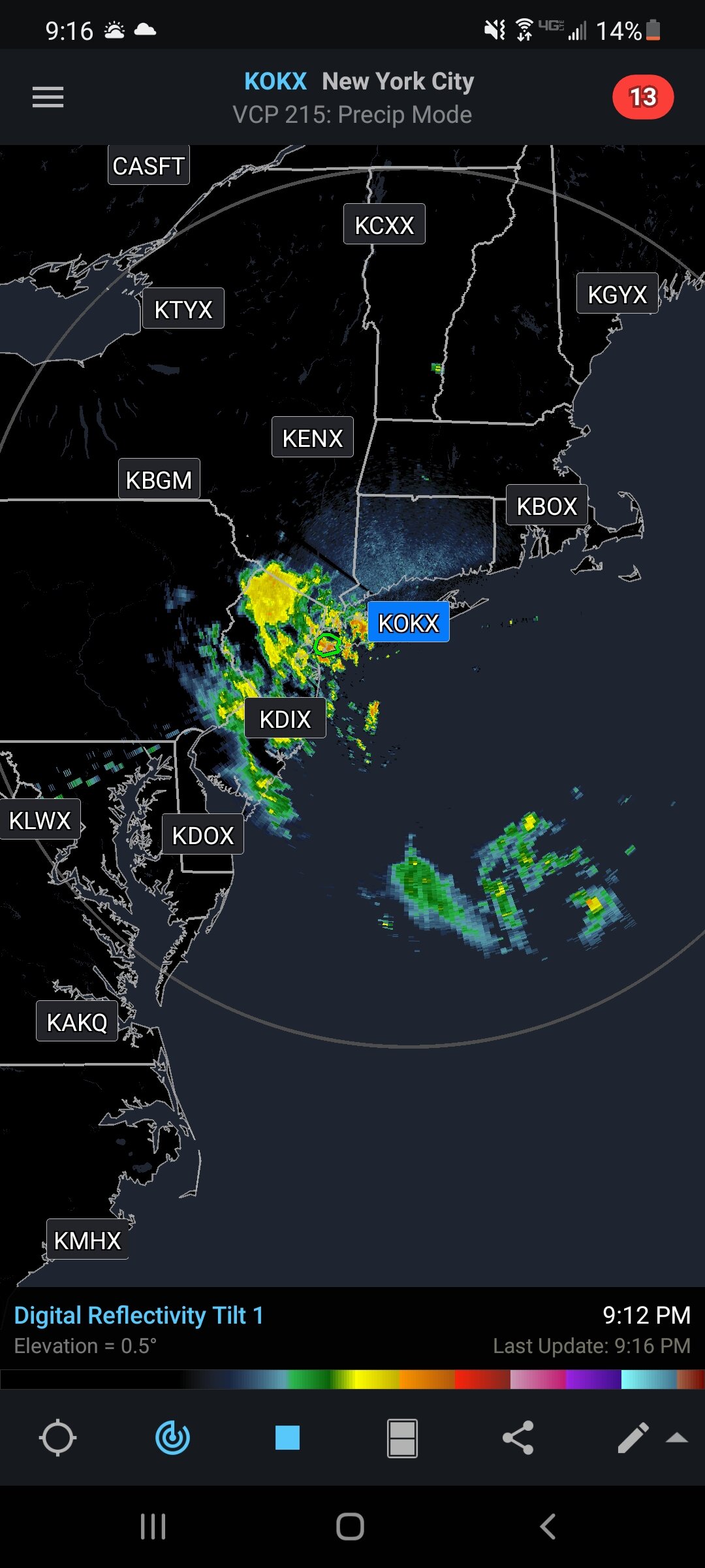
Time for some radar tracking... Here comes the center

-
 1
1
-
-
-
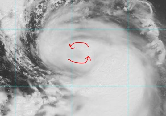
tighter rotation showing up in latest images.
-
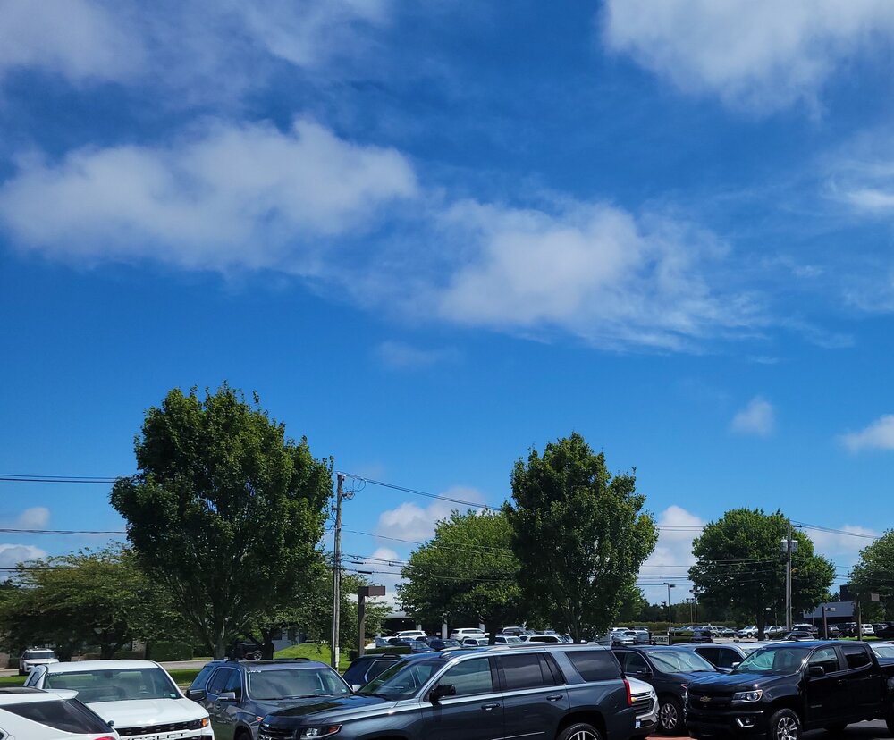
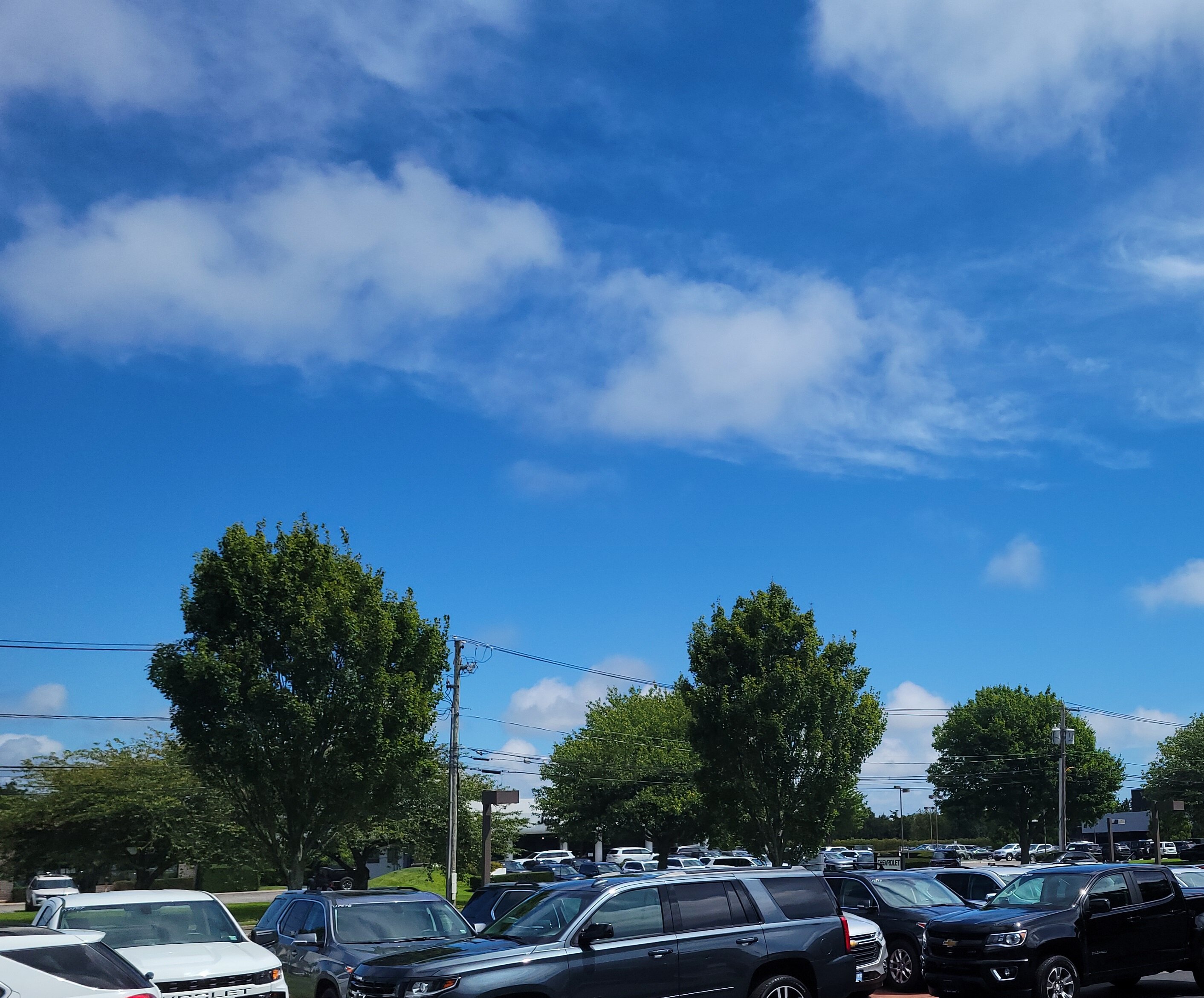
Hamptons on Long Island beautiful sky. Lots of low lvl clouds screaming northward
-
4
-
-
Maybe??

-
 5
5
-
-
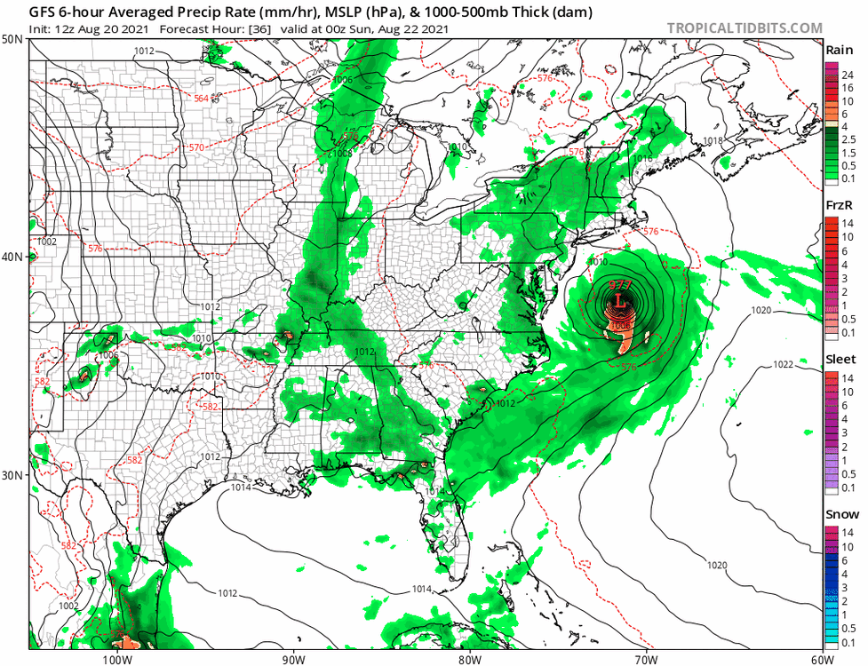
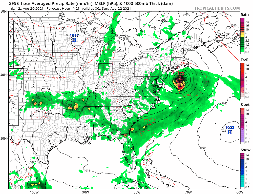
gfs oh so slightly S and 1mb weaker
-
1
-
-
Just now, MJO812 said:
We have seen blizzards with a lower pressure than what the storm is predicted to be up here.
Yeah but how much foliage is on your trees during a blizzard? Lot weaker winds can take down a whole lot more trees in this scenario.
-
2
-
-
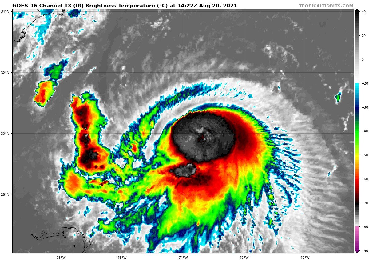
Henri is a hurricane as of 11am
..HENRI IS NOW A HURRICANE...
...A DANGEROUS STORM SURGE, HURRICANE CONDITIONS, AND FLOODING
RAINFALL EXPECTED IN PORTIONS OF THE NORTHEAST UNITED STATES
BEGINNING LATE TONIGHT OR EARLY SUNDAY...


SUMMARY OF 1100 AM EDT...1500 UTC...INFORMATION
-----------------------------------------------
LOCATION...34.4N 72.5W
ABOUT 180 MI...290 KM ESE OF CAPE HATTERAS NORTH CAROLINA
ABOUT 465 MI...745 KM S OF MONTAUK POINT NEW YORK
MAXIMUM SUSTAINED WINDS...75 MPH...120 KM/H
PRESENT MOVEMENT...NNE OR 20 DEGREES AT 14 MPH...22 KM/H
MINIMUM CENTRAL PRESSURE...991 MB...29.27 INCHES
-
2
-
 1
1
-
-
GFS coming in slightly S and stronger than 12z

-
2 minutes ago, Typhoon Tip said:
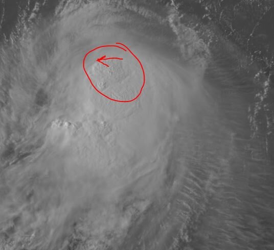
that's been doing that all day ... That region immediately/adjacent and west of your circled annotation is probably dim sun over 15' seas.
agreed but it was much more disjointed earlier in the day. Almost to the point you could clearly make out the LLC to the NW of the main convection.
-
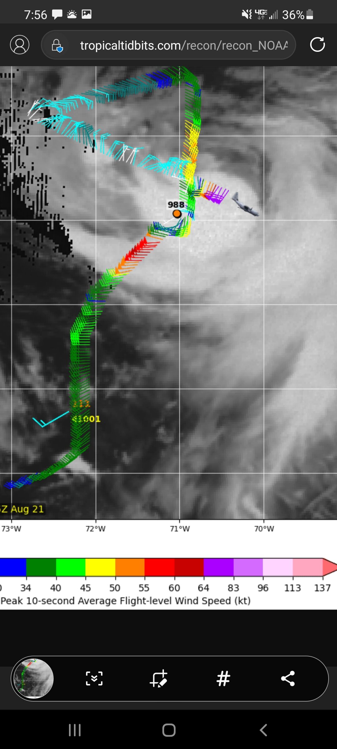
Looking at the lastest vis sat loop. Stronger convection appears to be moving much closer to the LLC.
-
2
-
-
Everyones phones blowing up with the Emergency Broadcast msg for Hurricane warnings now in effect for the Southern areas.
Henri Local Watch/Warning Statement/Advisory Number 20 National Weather Service New York NY AL082021 501 PM EDT Fri Aug 20 2021 NYZ081-210515- /O.NEW.KOKX.SS.W.1008.210820T2101Z-000000T0000Z/ /O.NEW.KOKX.HU.W.1008.210820T2101Z-000000T0000Z/ /O.UPG.KOKX.SS.A.1008.000000T0000Z-000000T0000Z/ /O.UPG.KOKX.HU.A.1008.000000T0000Z-000000T0000Z/ Southeast Suffolk- 501 PM EDT Fri Aug 20 2021 ...HURRICANE WARNING IN EFFECT... ...STORM SURGE WARNING IN EFFECT... A Hurricane Warning means hurricane-force winds are expected somewhere within this area within the next 36 hours A Storm Surge Warning means there is a danger of life-threatening inundation, from rising water moving inland from the coastline, somewhere within this area within the next 36 hours * LOCATIONS AFFECTED - Mastic Beach - Hampton Bays - Montauk Point * WIND - LATEST LOCAL FORECAST: Equivalent Strong Tropical Storm force wind - Peak Wind Forecast: 50-65 mph with gusts to 80 mph - Window for Tropical Storm force winds: Saturday evening until early Monday morning - THREAT TO LIFE AND PROPERTY THAT INCLUDES TYPICAL FORECAST UNCERTAINTY IN TRACK, SIZE AND INTENSITY: Potential for wind 74 to 110 mph - The wind threat has increased from the previous assessment. - PLAN: Plan for life-threatening wind of equivalent CAT 1 or 2 hurricane force. - PREPARE: Remaining efforts to protect life and property should be urgently completed. Prepare for considerable wind damage. - ACT: Move to safe shelter before the wind becomes hazardous. - POTENTIAL IMPACTS: Extensive - Considerable roof damage to sturdy buildings, with some having window, door, and garage door failures leading to structural damage. Mobile homes severely damaged, with some destroyed. Damage accentuated by airborne projectiles. Locations may be uninhabitable for weeks. - Many large trees snapped or uprooted along with fences and roadway signs blown over. - Some roads impassable from large debris, and more within urban or heavily wooded places. Several bridges, causeways, and access routes impassable. - Large areas with power and communications outages. * STORM SURGE - LATEST LOCAL FORECAST: Life-threatening storm surge possible - Peak Storm Surge Inundation: The potential for 2-4 feet above ground somewhere within surge prone areas - Window of concern: early Sunday morning until Sunday evening - THREAT TO LIFE AND PROPERTY THAT INCLUDES TYPICAL FORECAST UNCERTAINTY IN TRACK, SIZE AND INTENSITY: Potential for storm surge flooding greater than 3 feet above ground - The storm surge threat has increased from the previous assessment. - PLAN: Plan for life-threatening storm surge flooding of greater than 3 feet above ground. - PREPARE: Evacuation efforts and flood preparations should soon be brought to completion before conditions become unsafe. - ACT: Leave immediately if evacuation orders are given for your area to avoid being cut off from emergency services or needlessly risk lives. - POTENTIAL IMPACTS: Significant - Areas of inundation with storm surge flooding accentuated by waves. Damage to several buildings, mainly near the coast. - Sections of near shore escape routes and secondary roads become weakened or washed out, especially in usually vulnerable low spots. Flood control systems and barriers may become stressed. - Major beach erosion with heavy surf breaching dunes. Very dangerous surf and rip currents. - Moderate damage to marinas, docks, boardwalks, and piers. Several small craft broken away from moorings, especially in unprotected anchorages. * FLOODING RAIN - LATEST LOCAL FORECAST: - Peak Rainfall Amounts: Additional 3-6 inches, with locally higher amounts - THREAT TO LIFE AND PROPERTY THAT INCLUDES TYPICAL FORECAST UNCERTAINTY IN TRACK, SIZE AND INTENSITY: Potential for major flooding rain - The flooding rain threat has increased from the previous assessment. - PLAN: Emergency plans should include the potential for major flooding from heavy rain. Evacuations and rescues are likely. - PREPARE: Strongly consider protective actions, especially if you are in an area vulnerable to flooding. - ACT: Heed any flood watches and warnings. Failure to take action will likely result in serious injury or loss of life. - POTENTIAL IMPACTS: Extensive - Major rainfall flooding may prompt many evacuations and rescues. - Rivers and streams may rapidly overflow their banks in multiple places. Small streams, creeks, canals, and ditches may become dangerous rivers. Flood control systems and barriers may become stressed. - In hilly terrain, destructive runoff may run quickly down valleys, and increase susceptibility to rockslides and mudslides. - Flood waters can enter many structures within multiple communities, some structures becoming uninhabitable or washed away. Many places where flood waters may cover escape routes. Streets and parking lots become rivers of moving water with underpasses submerged. Driving conditions become dangerous. Many road and bridge closures with some weakened or washed out. * TORNADO - LATEST LOCAL FORECAST: - Situation is unfavorable for tornadoes - THREAT TO LIFE AND PROPERTY THAT INCLUDES TYPICAL FORECAST UNCERTAINTY IN TRACK, SIZE AND INTENSITY: Tornadoes not expected - The tornado threat has remained nearly steady from the previous assessment. - PLAN: Tornadoes are not expected. Showers and thunderstorms with gusty winds may still occur. - PREPARE: Little to no preparations needed to protect against tornadoes at this time. Keep informed of the latest tornado situation. - ACT: Listen for changes in the forecast. - POTENTIAL IMPACTS: Little to None - Little to no potential impacts from tornadoes. * FOR MORE INFORMATION: - http://scoem.suffolkcountyny.gov - https://weather.gov/nyc - https://ready.gov/hurricanes -
2pm
994mb
NNW 6mph
70MPH winds
-
look at her blossom..
-
very impressive on the ir loop over the last few hrs.

-
18z GFS coming in colder also.
-
1
-
-
-
-
Any reports from SE Mass? Radar looks sick!
-
Absolutely puking snow right now in Sag Harbor. All out accumulation is gonna come in the next hr or 2
-
1
-
-
Coastal NJ in on the warnings now too.
QuoteThe only notable changes were to expand the Winter Storm Warning into coastal Monmouth County and inland Ocean County given forecast totals sufficient to warrant a warning. The Winter Weather Advisory was also expanded into coastal Ocean County for similar reasoning. Some of the latest high-res guidance tries to hold onto the light snow for a couple extra hours along and north of I-195, so totals seem more probable to exceed the thresholds for the new areas in the Warning/Advisory. It should be noted that there is the potential for higher snowfall amounts within the band (where rates may approach 2 inches an hour), but would like to really get in the CAMs temporal wheelhouse (e.g. <24 hours) before increasing amounts further.
-
That forecast is actually from much earlier this morning. They did not change the verbiage for the 1:33pm update. That is still based off the 0Z model data
-
1
-
-
GFS looking better at H5 through 30hr. bit more digging.
-
2
-
-
Just now, kenrad said:
Per LSRs, did you get around 3" in the last 1.5 hours?
EASY! i picked up over 5" in a little over an hr
-
3
-


Major Hurricane Ida
in Tropical Headquarters
Posted
lets not forget what Katrina looked like before all those famous "eye" shots. With RI it won't take much for this to have the "look" everyone has been waiting for.