

wthrmn654
-
Posts
2,420 -
Joined
-
Last visited
Content Type
Profiles
Blogs
Forums
American Weather
Media Demo
Store
Gallery
Posts posted by wthrmn654
-
-
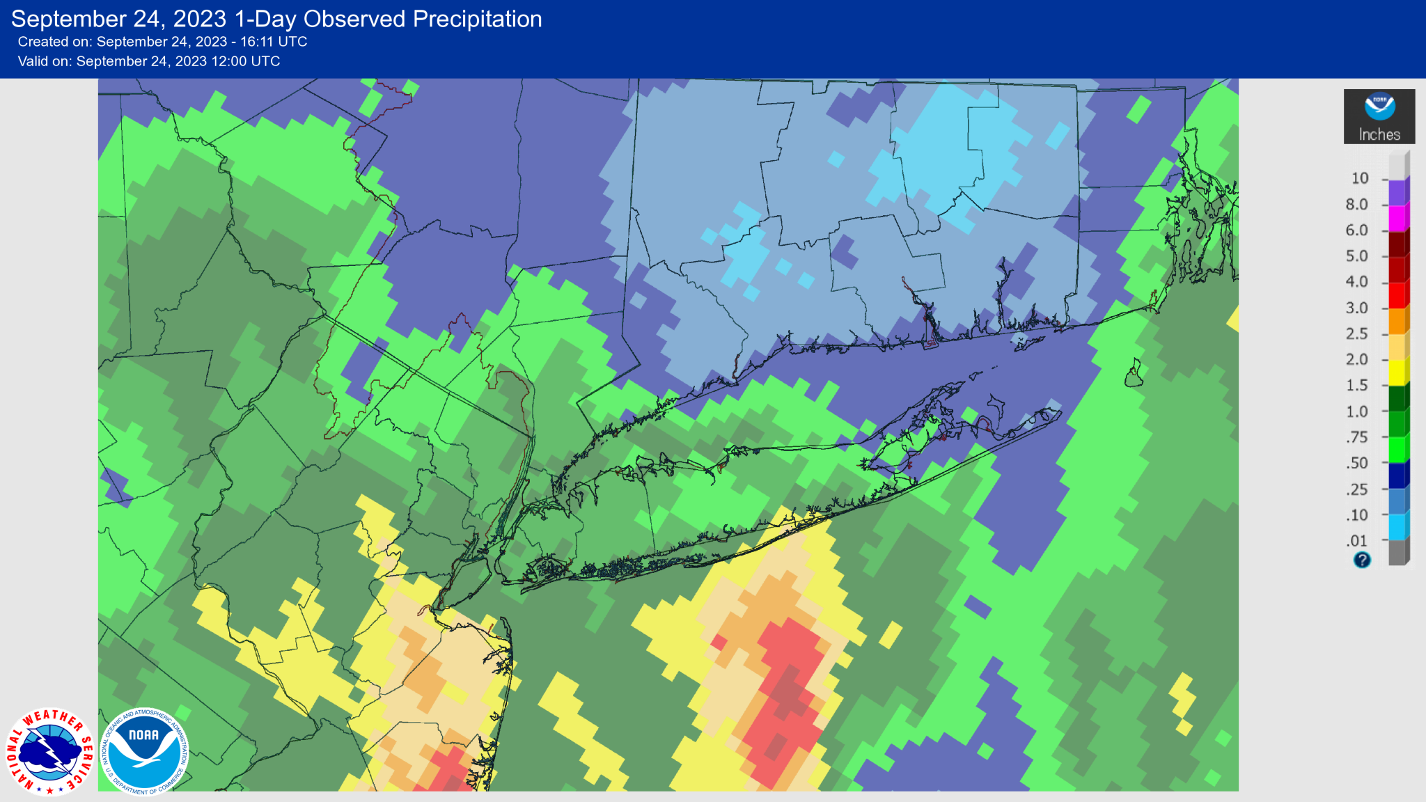
Current total on my new station at my house is 1.43 inches. At my parents house on the older (2008)Davis pro2 plus, there at 1.31 inches.
At my state park coop station, I've recorded, 1.58 inches.
All 3 locations are in orient, with my house station about 1.5 miles away from the parks. And my house to my parents about 2.3 miles so roughly about 2 miles distance difference.
The totals were less uniform yesterday I will say.
-
 1
1
-
-
10 hours ago, psv88 said:
Flooding downtown?
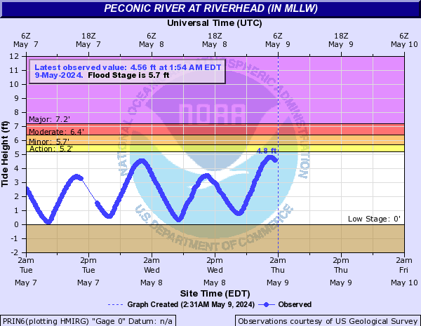
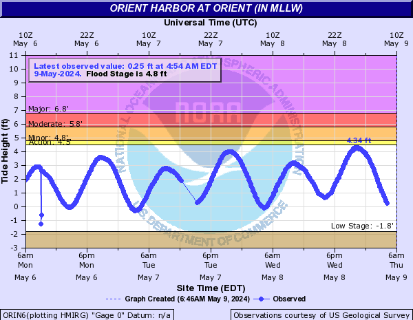
I would imagine there gauge has been running higher then forecast and the nws ended up doing the coastal flood advisory and putting up a statement for our end and last night ended up being highest to date for this high tide cycle lol. There final high was about 7.25 feet.
Tonight high tide is apart to be highest region wide as per nws 730 update.
Here's riverhead past several days and orient gauges for example.
For some reason riverhead doesn't show as many days but you get the idea.
-
Wow forecast was 5.6 feet at 9 pm. Actual height 7.22
Pretty bad slap to the face forecast fail.
-
7.22 major flood stage riverhead
-
Flood gauge in riverhead, just about hit major tonight, we'll above forecast... orient gauge was 4.13 just shy of minor, also above forecast.
-
1.35 and quickly going up. Impressive to say the least
-
.NEAR TERM /THROUGH TONIGHT/...
-- Changed Discussion --Early afternoon update: Winds have trended stronger especially along the coast, with LGA gusting up to 38 kt. Think this will be a brief surge of higher wind farther west, but be more prevalent farther east across SE CT and central/eastern Long Island. Bands of rain with the remnant low have been more prevalent across S CT, Westchester/Putnam and parts of central Long Island, with amts of 1/4 to 1/2 inch per MRMS estimate from 12Z-18Z today, and similar amts may be possible in those same areas late this afternoon into this evening. Gusty easterly winds continue through tonight, however the rain will begin to get lighter from north to south as any forcing weakens further. Skies will remain cloudy with a rather small temperature range due to gusty winds and cloud cover. Therefore temperatures will average below normal today by around 10 degrees or so, but average near normal tonight. Any shower activity tonight should be rather light with amounts under a quarter inch, and perhaps closer to a tenth of an inch tonight, mainly across southern portions of the area.
-- End Changed Discussion -- -
0.95 and still adding on lol
-
4 hours ago, nycwinter said:
i have had a the heat quite a few times before this weekend even in manhattan..
Your not old enough to be constantly cold like my parents and grandparents are you?!
-
Snail pace catching up to everyone.
-
0.74.... my God this maybe the longest stretched out storm I can remember in recent time..... Saturday and Sunday and were still not done.
-
1 hour ago, psv88 said:
Suffolk county missing the worst again. Ready for some real coastal for a change. Been a while
Finally got a band little ago dumped.0.30 within a few mintues it seemed.. won't take much if you get a downpour
-
43 minutes ago, Rjay said:
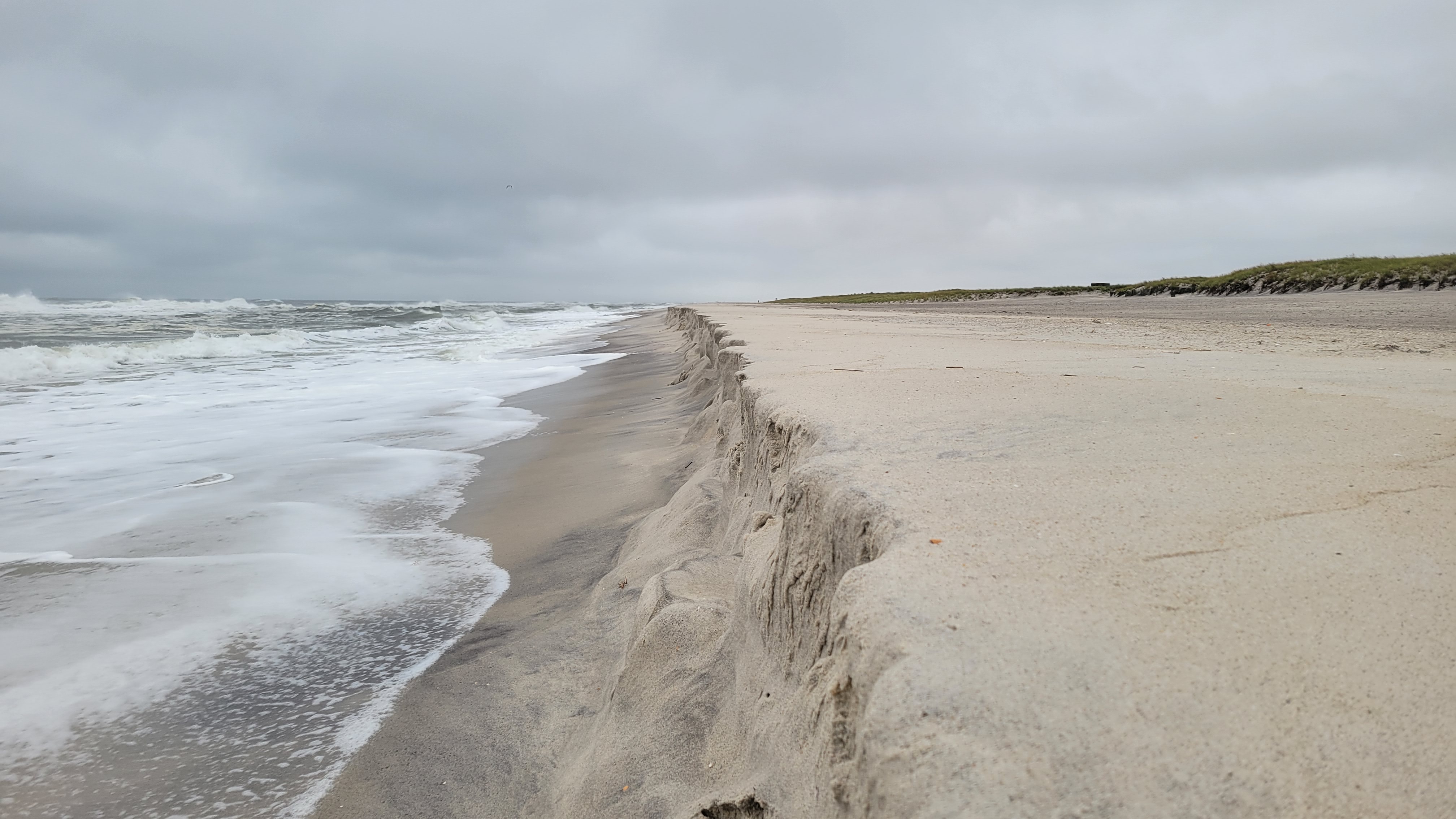
Just a bit of erosion at Robert Moses

Same at orient beach, we'll see when I go to work just how much more happened overnight.
-
Got a nice band finally! Up to about 0.70 finally
-
-
Rain amounts on the island have been all over the place it seems.
Montauk point somehow got 0.79 so far as of this morning, I have 0.40 roughly, 0.34 i think in islip. But wear off that is in the 1 inch or more range.
-
The winners and the losers for today's rain.
0.30 mainly within the past hour here
-
0.13 but plenty of wind that's for sure
-
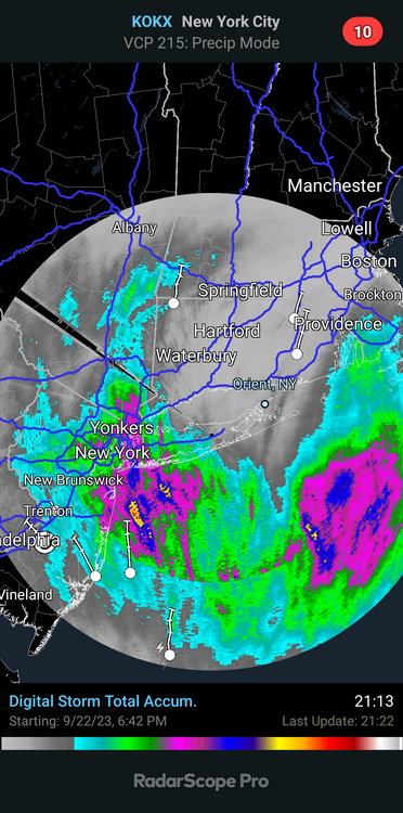
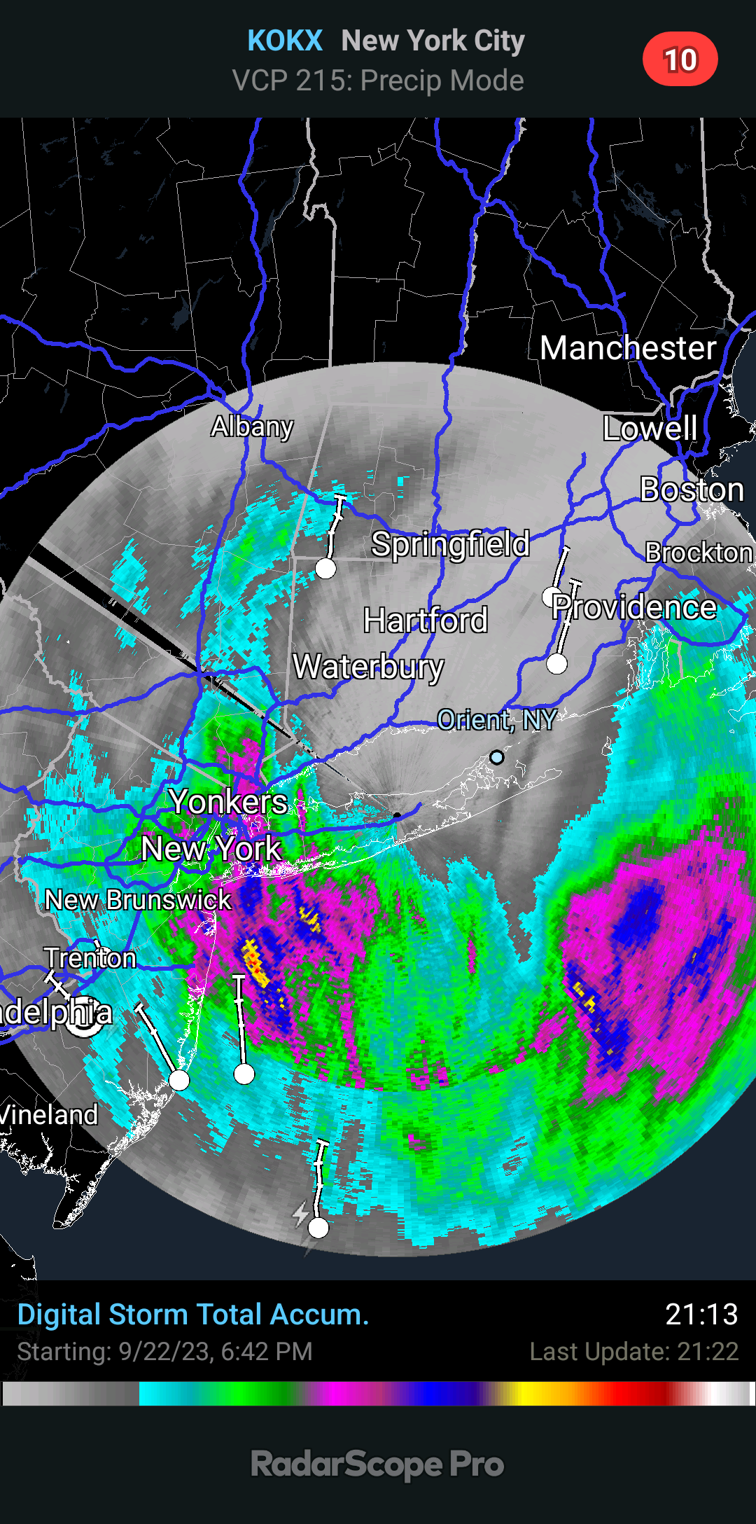
Just look at radar, rains already showing up on our radar and is steadily moving north with little interference.
-
They don't cancel those big events. It's all about the $$$ .I work for parks not to mentions all that already signed up
-
2 hours ago, wdrag said:
May be time to get this into separate subject... now that NHC has it as a disturbance eventually turning out to near the benchmark. I won't be able to do anything with this after 4P and for me probably needs another ensemble cycle (00z/22). I sure hope this isn't another (as in the 7th-14th of Sep) non watch FFW situation for PHL/NYC metro areas this weekend. General stream flow potential is low but it seems to me that 6 hr FFG for ne NJ is under 2"= vulnerable. Monitoring
NBM v4.1 probabilities of >2" over the 24 hours ending 12Z Sunday continue to increase, now showing a widespread 40-50% across most of the forecast region, up from about 30-40% last night. Probabilities of >1" in any 6 hours has nudged up some for Saturday AM into early afternoon, and this is the window of greatest concern for locally heavy downpours. Overall, global ensembles paint a widespread 1" to 2.5" Saturday into early Monday for the area, with still some spread amongst members. RFC 3 hr flash flood guidance is over 2" for much of the region, with the exception of parts of NE NJ, where values fall to around 1.5". This would be the area of greatest concern for any flash flood potential, though certainly cannot be ruled out elsewhere. More likely, nuisance flooding with the long duration rainfall is likely with ponding and poor runoff areas. WPC has maintained a slight risk for excessive rainfall, indicating the potential for isolated to scattered areas of flash flooding.-
1
-
-
1 hour ago, bluewave said:
It’s funny how the OP Euro and machine learning models were both showing landfalls in SE New England in earlier runs before correcting further east toward the consensus. As to why this was the case, we can leave to the modelers writing the code. It may come down to the OP Euro being over amped at times for some reason. But this bias at times can work like in Sandy when the pattern was super amped up. So I guess some storms play to certain model biases depending on the situation. If they could train the AI to learn how and which biases to correct on a situational basis, then they will really have something.
In a recent ECMWF blog and a Newsletter article, we’ve been highlighting the rapid rise of data-driven forecasts. These are produced by machine-learning-based forecasting models, created by innovators such as NVIDIA, Huawei and Google DeepMind.
The ERA5 reanalysis, produced by the EU-funded Copernicus Climate Change Service (C3S) implemented by ECMWF, is the dataset used to train these models. They can make accurate 10-day forecasts when provided with good initial conditions.
This summer, we focused on analysing Huawei’s Pangu-Weather to understand its strengths and weaknesses, with results collated in a submitted manuscript. At this early stage in the technology, some results are already displaying comparable skill to ECMWF’s Integrated Forecasting System (IFS), which is an exciting achievement.
Gfs in the super long range also had been showing a direct hit in the north east while the euro at its longest range was more east orginally.
-
Gfs on 2021 was ranked best for hurricanes, not sure how it ranked on 2022, but I'd assume similar ranking as well.
-
Gefs and gfs at 18z went west maybe 50 miles was on the 65W line hard


Tropical Storm Ophelia
in New York City Metro
Posted
Big surprise shock, nws says peconic river gauge out of service. To high lol