

lj0109
-
Posts
328 -
Joined
-
Last visited
Content Type
Profiles
Blogs
Forums
American Weather
Media Demo
Store
Gallery
Posts posted by lj0109
-
-
Currently sitting at 32.9/27.7 at 15:30 in Saint Matthews, SC (Calhoun County)
-
 1
1
-
-
CAE's latest thoughts:
Area Forecast Discussion
National Weather Service Columbia SC
335 PM EST Tue Jan 18 2022
.SYNOPSIS...
High pressure and a dry airmass will remain over the region
through Wednesday, producing more typical January weather. A
cold front moves into the area Thursday bringing a good chance
of rain. Friday into the weekend look very unsettled with a mix
of wintry weather expected through Saturday. Conditions improve
Sunday into the first part of next week.
.SHORT TERM /WEDNESDAY THROUGH THURSDAY NIGHT/...
Wednesday looks to be the primary transition day as the surface
high pressure center will slowly shift offshore. Southwest
surface and 850mb flow will ramp up throughout the day as the
high exits and central CONUS shortwave approaches allowing
modest moisture into the area with dew points climbing into the
upper 30`s and low 40`s. Cloud cover is expected to persist
throughout the day given the overrunning and moisture return at
low-mid levels. High temperatures will finally jump above
average for the first time in several days, generally in the low
60`s across the area. Southwest flow will continue ahead of the
front associated with the shortwave off to the west into
Wednesday night. There is good consensus across guidance on the
overall timing of the front, entering the forecast area from the
northwest around 12z Thursday and progressively sliding
southeast through the area by 18z. Overall precip totals will be
fairly low given the mountain interaction and general lack of
synoptic lift. The arctic airmass begins filling in behind this
front and this is where things start to get more uncertain. The
front is expected to slow and stall as a weak area of low
pressure develops along the Gulf coast and northern Florida.
Guidance is somewhat consistent is showing PoPs continuing into
late Thursday as the front stalls but the interaction with the
diving cold air is the primary uncertainty. Regardless of model
solution, the surface layer air should remain too warm for any
frozen precip until early Friday morning. Some wintry PoPs begin
across our extreme northern counties between 06z and 12z
Friday.
.LONG TERM /FRIDAY THROUGH TUESDAY/...
While a somewhat clearer picture has developed in the last few
model suites, there is still relatively high uncertainty in the
Friday-weekend system will play out. The mid-upper level flow is
inherently chaotic and unstable for run to run consistency with
numerous shortwaves embedded across the general southwest flow
across the CONUS. So this type of uncertainty is annoyingly
expected given the pattern. Each global operational model and
its corresponding ensemble are depicting somewhat unique
solutions on how both the upper level pattern will develop over
the northeast and southwest CONUS, and how the low pressure
center will develop along the stalling cold front. Friday
appears to be coming into clearer focus, albeit slowly, with
NAM, ECMWF, and GFS all developing a broad shield of overrunning
over top the southward rushing arctic airmass as strong south-
southwest flow ramps up. Associated ensembles are still quite
scattered in timing and intensity of this precip, but at least
there is a decent signal compared to 24 hours ago. Obviously
this interaction between a thin cold layer, sharp mid level
trough, strong upper level jet, and weakly developing low
pressure is tricky and guidance likely not get a good handle on
it for another day or so. So current thinking on Friday wintry
precip is increasing slightly in confidence but intensity
remains a big question mark as does spatial extent. All wintry
precip types are possible at this time across the fa,
particularly sleet and freezing rain. We should start to see
better agreement in the next suite or two over the specifics of
the Friday event.
More uncertainty develops for how the shortwave over the
southwest CONUS and western Gulf will track east and then
interact with stalled front. The GFS and associated ensembles
are more aggressive with pushing the shortwave east and spinning
up the stalled front in the Gulf. This then swings another
batch of wintry precip into the fa Saturday and would
dramatically increase impacts. The EC and Canadian ensembles and
operational are much more suppressed with this second
shortwave, so impacts would be minimal or none. Again with the
complexity of the 500 mb pattern, this will be inherently
unstable run to run so not expecting consistency for another run
or two.
In general, there is a large spread of possible outcomes with
this event ranging from mild inconvenience to highly impactful
winter storm across the Midlands and CSRA.
Cold temps fill in behind this regardless of what plays out and
the long term is expected to remain well below average. -
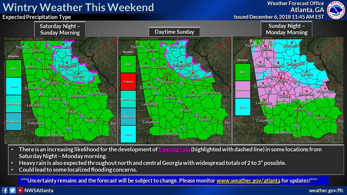
CAE issues Winter Storm Watch for northern tier of CWA:
URGENT - WINTER WEATHER MESSAGE
National Weather Service Columbia SC
338 PM EST Thu Jan 13 2022

Chesterfield-Newberry-Fairfield-Kershaw-Northern Lancaster-
Southern Lancaster-
Including the cities of Cheraw, Pageland, Newberry, Winnsboro,
Winnsboro Mills, Camden, Lugoff, Indian Land, Lancaster, Elgin,
and Lancaster Mill
338 PM EST Thu Jan 13 2022

...WINTER STORM WATCH IN EFFECT FROM LATE SATURDAY NIGHT THROUGH
LATE SUNDAY NIGHT...

* WHAT...Heavy mixed precipitation possible. Total snow
  accumulations of up to two inches and ice accumulations of one
  tenth to one quarter of an inch possible.

* WHERE...Portions of central South Carolina.

* WHEN...From late Saturday night through late Sunday night.

* IMPACTS...Power outages and tree damage are likely due to the
  ice. Travel could be nearly impossible.
-
2 minutes ago, ILMRoss said:
I will say, one thing i don't use the regular NAM for is precipitation depiction. I've always thought it has looked a bit 'off' with its precipitation depiction, dry areas where I'd expect more precip, etc. I think it's fun to look at but I don't hang my hat on it- I lean on the 3km a lot more for that in my internal calculus.
Agree with this 100%. Precipitation usually over performs compared to the regular NAM's output.
-
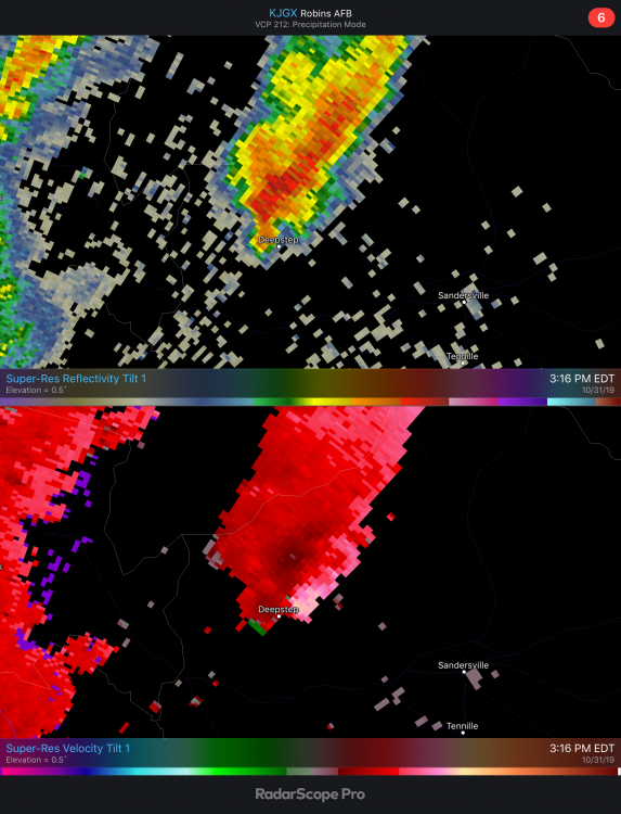
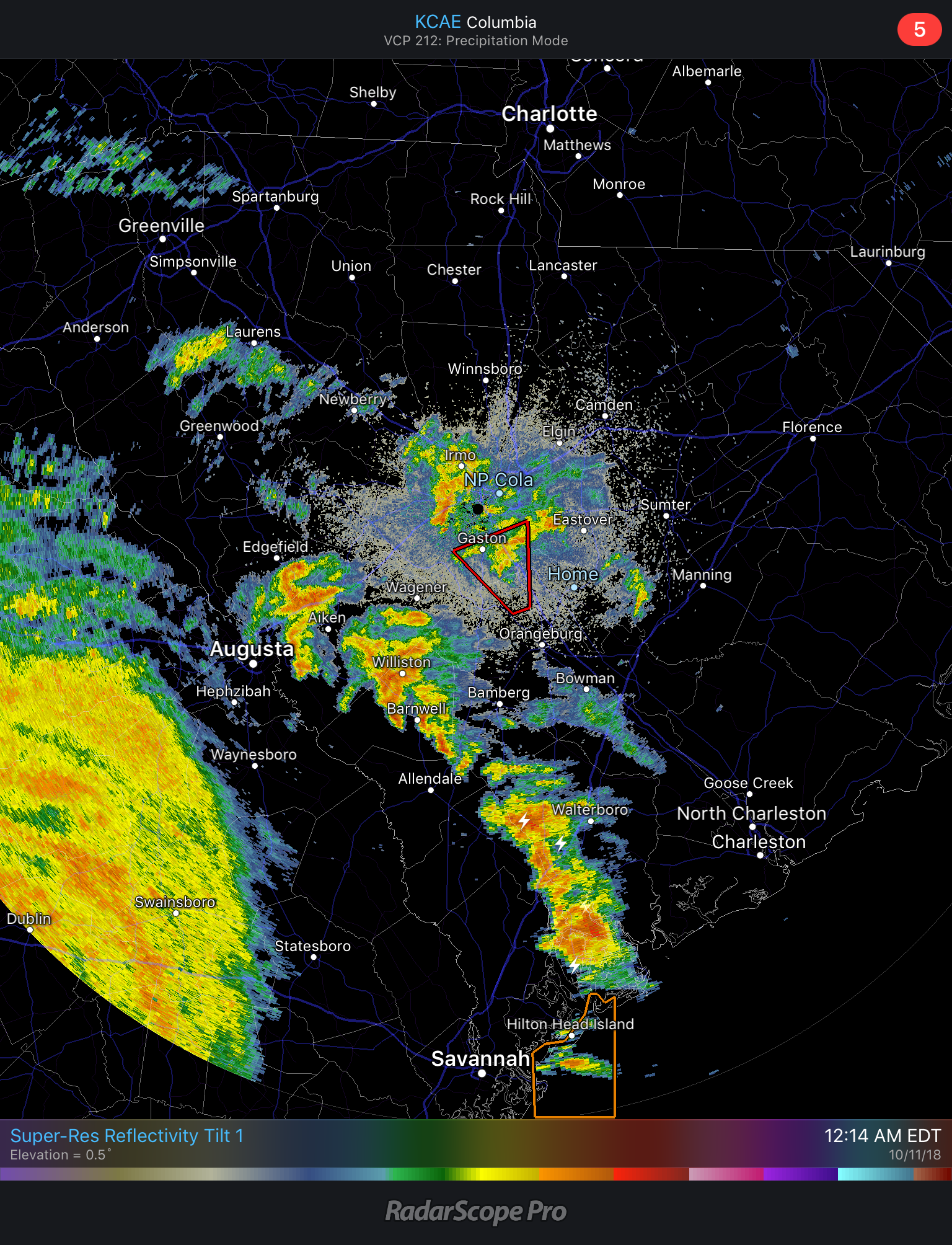
A few of the discrete cells across E-Central GA are trying to get their act together:
-
18 hours ago, TellicoWx said:
Power Flashes reported on I20 at MM49 10 mins ago
That was my report. I was on the way back to Columbia from Nashville via ATL and was monitoring that cell as I was approaching CAE. Wish I had a dash cam for the footage, it was pretty incredible to see the sky light up as crossed I-20 about 3M to my East.
-
@Lookout FFC starting to chime in on the FZRA threat around the Athens/Gainesville area that you have been discussing over the last few days:

-
Several Tornado Warnings already issued in the bands setting up across southern and central SC

-
1
-
-
9 minutes ago, downeastnc said:
I imagine there will be TS watches/warnings along the coast and sounds but I wonder if MHX/ILM/RAH are going to go with inland tropical storm warnings or maybe just regular wind products.....
I wouldn't be surprised if ILM went with a few inland Tropical Storm Watches/Warnings especially around the SC/NC border. CAE just issued a Tropical Storm Watch for the eastern tier of its CWA as of 11AM.
-
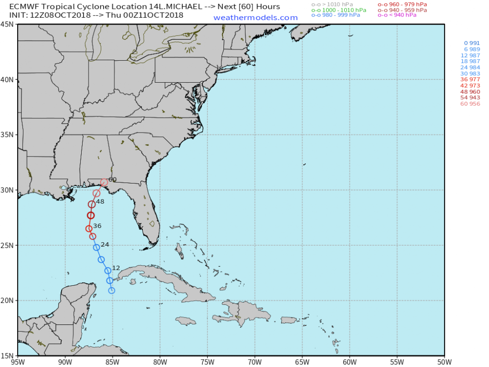
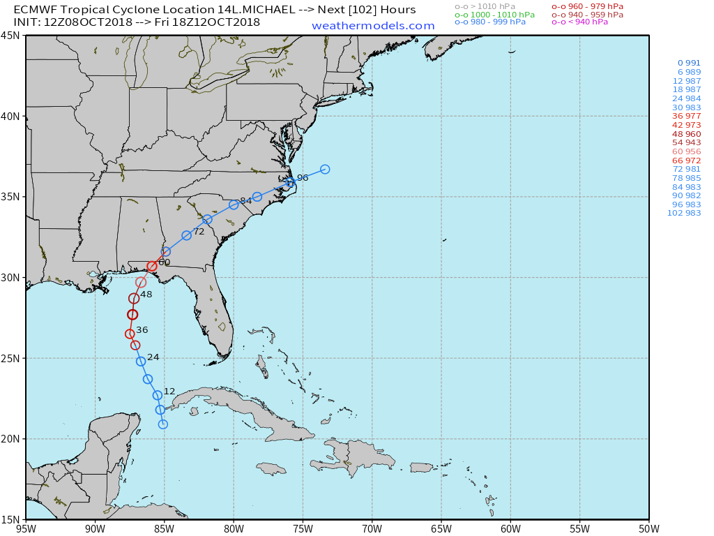
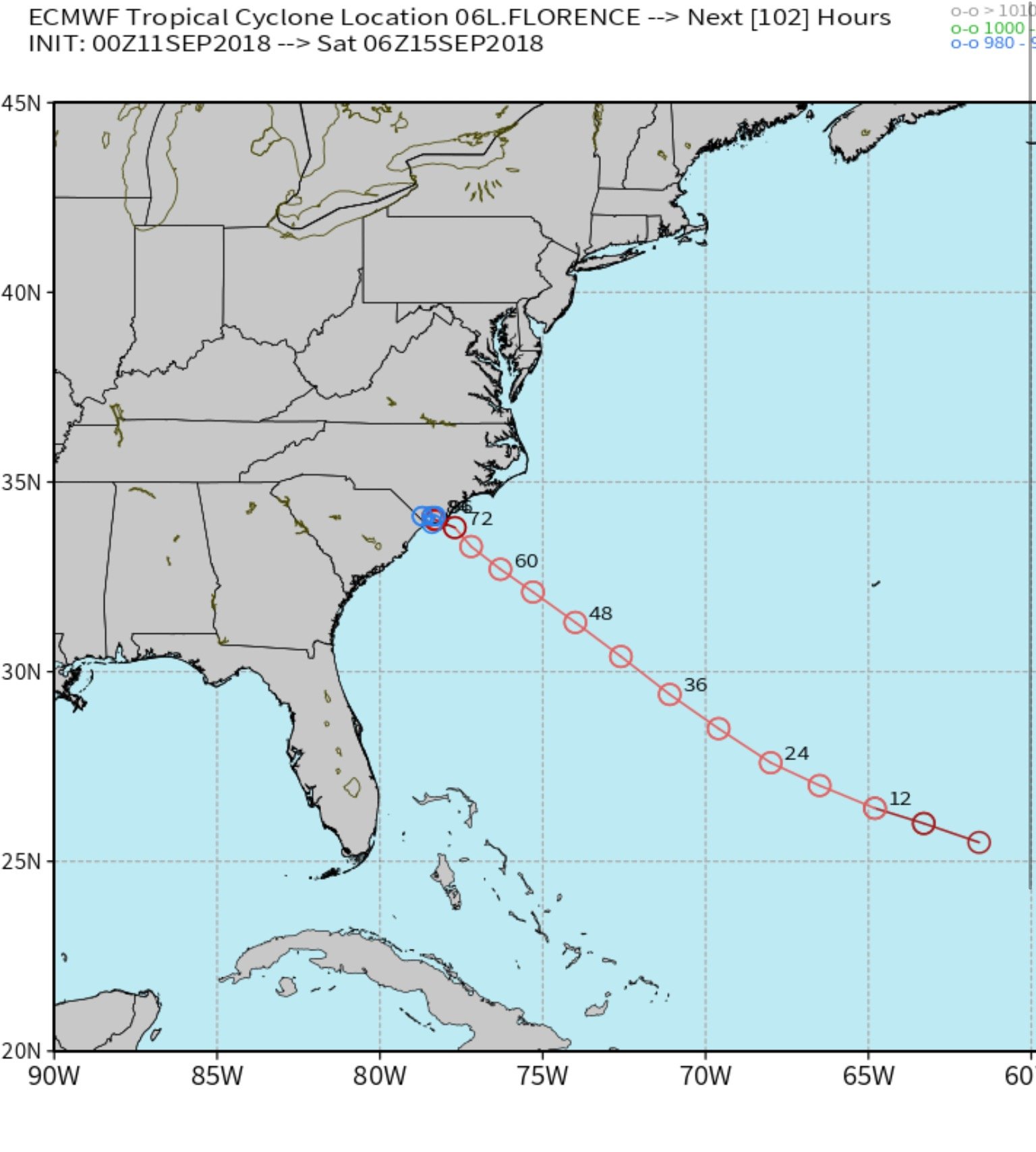
12Z Euro up to Hour 102:

-
12Z Euro makes landfall west of PCB near Seaside/Rosemary Beach
-
1
-
-
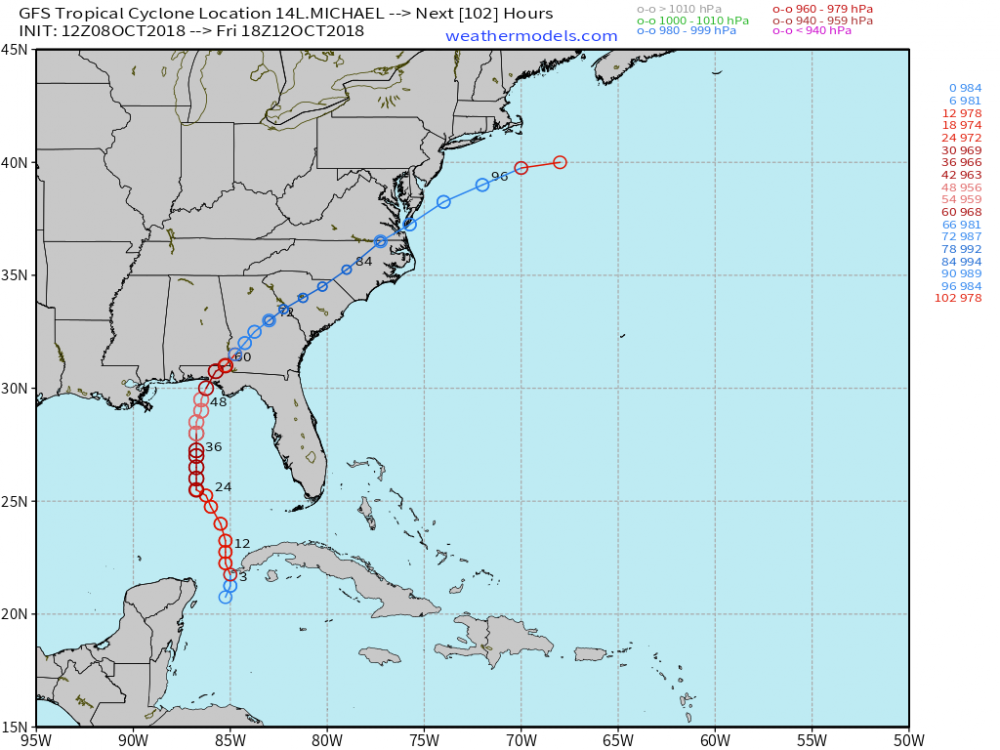
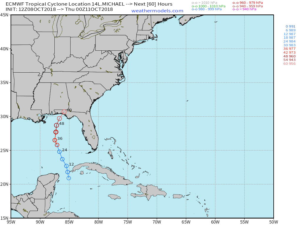
12Z Euro rolling now....A lot faster vs 00Z.
-
12Z GFS:
-
5 minutes ago, downeastnc said:
That's a decent west shift....the 06Z in front of the Euro throws me off lol.....the stronger storms stay east though that cluster of ens has shifted west quite a bit as well
Yep! The 06Z Euro EPS Mean is pretty dang close to the 00Z UK OP with regards to the track over the Carolinas. Will be interesting to see what the 12Z UK and Euro show in the next few hours...

-
06Z Euro EPS:

-
55 minutes ago, jbenedet said:
Yes. Always is. Worth noting that GFS and Hwrf trended towards the Euro op idea of paralleling the coast. That track —in general—is gaining credibility that’s all that can be said right now. Hopefully EPS narrows the posts through hr 48.
12Z Euro EPS

-
1
-
-
11 minutes ago, MikeB_01 said:
Maybe someone can help me understand this. I am looking at the steering layers and see a pretty clear path into eastern carolina - seems to be inline with where the majority of the models were yesterday. GFS moved away from there today and close to the Euro. Can anyone maybe point to something that would be driving it further south contrary to what it looks like in the steering layers of the atomosphere?
A stronger ridge over the Atlantic to the N/NE of Florence coupled with another ridge in the Great Lakes Region evolving into the OH Valley are the culprits to the further South and West trajectory.
-
1 minute ago, StormyClearweather said:
Then crawls west across Central SC. Brutal for NE SC and Eastern NC

-
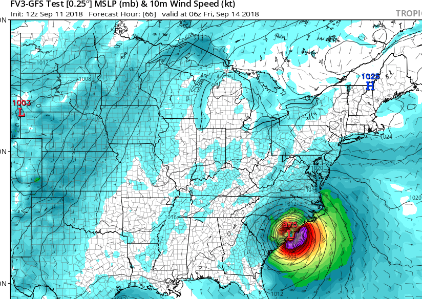
12Z FV3-GFS now more southwest as well. Landfall at MYR then crawling west across Central SC:
-
5 minutes ago, LovintheWhiteFluff said:
Then heads SW to Florence, SC at 120hr
Yep Florence, meet Florence

-
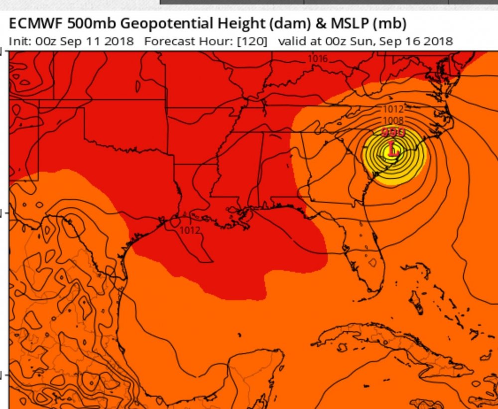
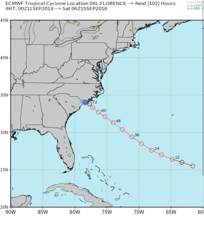
At 120 Florence is pretty much centered over....Florence, SC:
-
1
-
-
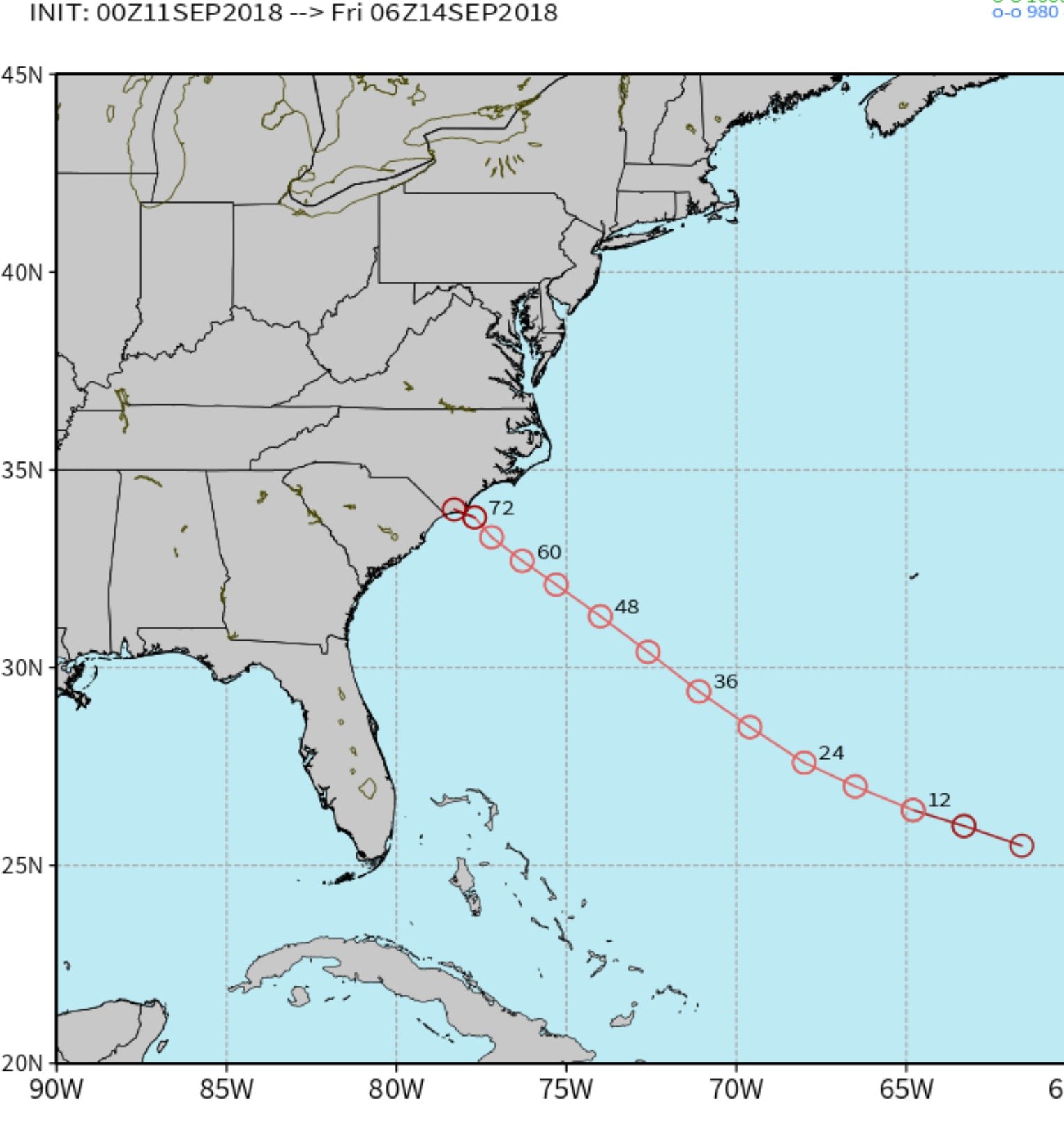
After making landfall near Holden Beach, still stalled at 102 near the NC/SC border...
-
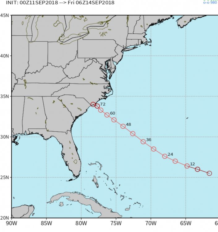
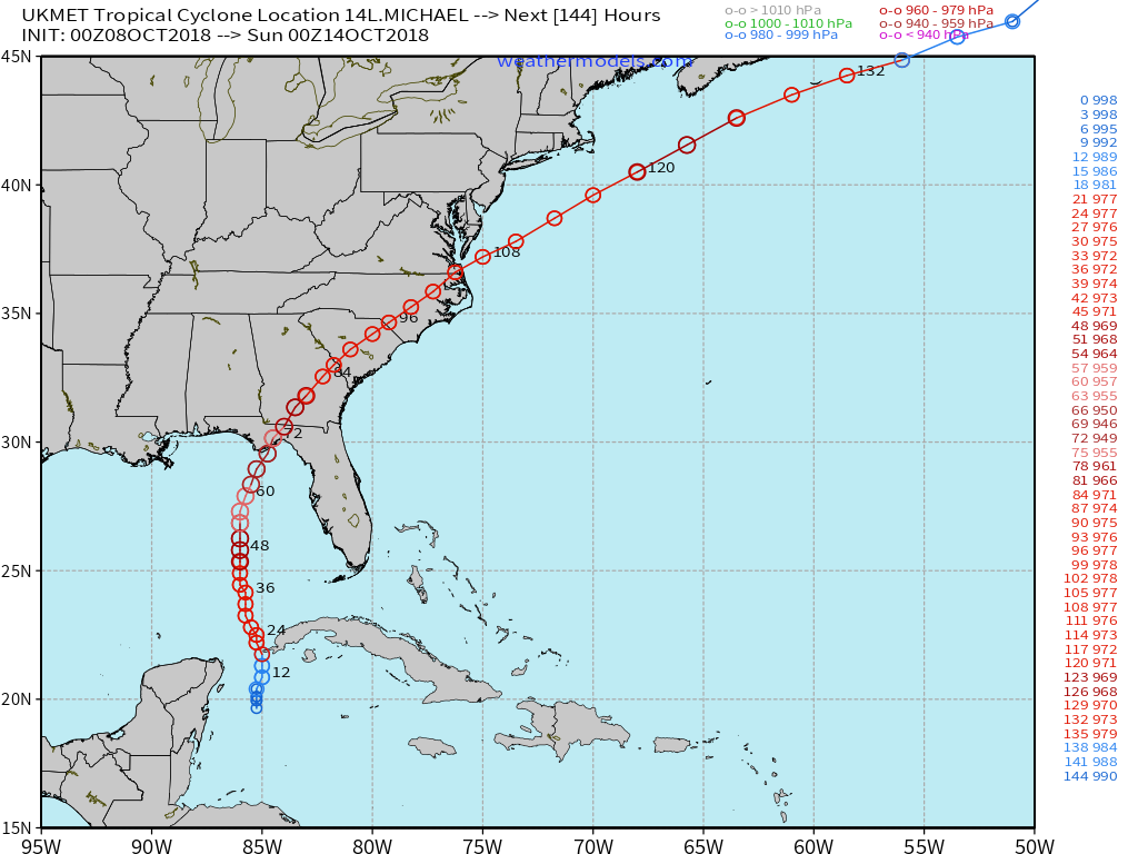
00Z Euro makes landfall just SW of ILM near Holden Beach
-
1
-
-
2 minutes ago, griteater said:
That seems a bit extreme for Charleston to Hilton Head, but playing it safe
Maybe for the extreme southern coast, but say a shift of 50-100 miles in a southward direction of the projected Euro track were to occur with only hours to spare...that would bring a large portion of SC into some pretty rough stuff, especially Charleston north and east... Way better to play it safe imho.
-
1
-


NW Trend For the Win! (1/21-1/22 2022 storm) Obs Thread
in Southeastern States
Posted
31.6 and freezing rain