

WintryMixmaster
-
Posts
113 -
Joined
-
Last visited
About WintryMixmaster

-
I liked the picture of the 1980 "Miracle on Ice" with "GFS" photoshopped over "USA" on the jerseys of the celebrating American players. That's what that storm seemed like to me, GFS got its once a decade upset over the Euro haha And yeah we also had on and off snow flurries for almost 24 hours, which is kind of crazy. Obviously no accumulation besides a trace on some of the roofs, but it was a nice surprise
-
Not really accumulating but some big fluffy flakes have been blowing in the wind, going back and forth between flurries and steady light snow. Looks nice and wintry, hopefully not the last ones of the season but they very well might be
-
A few stray flurries here tonight
-
I'll take a shot, I've been following along with this storm since I have a lot of friends and family in NJ/PA (plus sometimes I like to pretend that 12 year old me is still in my childhood backyard in NJ measuring snow) NYC: 12.9 LGA: 13.0 ISP: 15.8 JFK: 13.9 EWR: 13.2 Bonus prediction for my current backyard, after careful consideration of all the models and trends Knoxville: 0.0
-
I love that it's always the happy hour GFS runs that somehow always dole out the most hope... I swear some government programmer put an Easter egg in the code to tweak the 18z GFS solutions towards colder/snowier just for us snow weenies lol
-
Oh yeah that's right, I remember it snowed all the way up into the northeast as the storm headed that way - though New Jersey didn't get as much as we did
-
My biggest snow here was in January 2024... my second biggest was March 2022. Do you remember the setup? I think it was a bowling ball ULL that dropped down from the north, but I remember it being very mild the day before, snowing extremely heavily overnight and into the morning hours, and ending with 6.5 inches. Quickly melted away in the afternoon sun and the next day as it warmed up again, but an exciting storm of a magnitude I never thought I'd experience in Knoxville again (until January 2024 came around that is). But I definitely never write off March after that, even if the odds are low
-
I hope you're right and these last 2 winters weren't just an anomaly. Though I think my favorite winter here was 2023-2024 - a big storm and snow on the ground for a week, but mild otherwise. Cold and dry is my least favorite kind of winter - though I know some others will disagree, since the cold at least makes it feel more like winter even without snow
-
About a quarter inch of snow at my house, I'm curious if there's larger totals up by Halls because it seemed like they were under a steadier band of snow for longer before it weakened as it moved south
-
A nice dusting on the grass and wet roads would be ideal for my drive to work tomorrow, especially since I'm sure the rain washed away the salt they put down for the last storm
-
Maybe that band of more steady snow that's currently in N Knox County/S Anderson County can get down here before dissipating
-
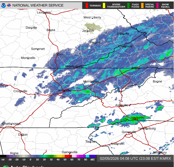
Very light snow has been falling here for about 30-45 minutes... there's a thin dusting (<0.1") on some of the colder elevated surfaces. Radar has had no reflections over my house though (snow hole along I-140, just south of the "K" in Knoxville on the map)
-
Some light rain/snow mix is falling at my place now too
-
33.4 and on and off drizzle, haven't seen any snow yet but its hard to tell with how little precip is falling
-
My first thought when I saw the snow hole was that maybe the high res models were overdoing some terrain effect... I didn't realize you were on the Virginia side of the Cumberland Gap, maybe the model just creates some super downslope effect in that area to try and more accurately match the erroneous snowfall totals in that area? I didn't realize the models got fed previous local snowfall data for future forecasts but it makes sense that if the models consistently busted high with respect to the erroneous data, someone would try and tweak the geography or something in the model to make it "more" (though in this case less lol) accurate for that location

