

Wild Weather Monger
-
Posts
365 -
Joined
-
Last visited
Content Type
Profiles
Blogs
Forums
American Weather
Media Demo
Store
Gallery
Posts posted by Wild Weather Monger
-
-
It's interesting that the UKMET never drives Karl inland.
Makes me wonder if there is any chance at all of the storm lingering in the Bay of Campeche and being picked up by the next trough?
-
2 hours ago, MANDA said:
Not to at all diminish the death toll, one is too many but I think this will likely be the costliest hurricane to hit Florida. Populated area, slow moving and intense at landfall. Swath of flooding as it crossed the state and some very expensive real estate in the way. We'll see hot it goes but for certain will fall into the top 3.
It would seem the loss of life with Ian in the US will be +- some 1700 fewer souls lost than Katrina. 1836 is Katrina's official death toll.
-
1 minute ago, mappy said:
I am sure it happens. I am not in FL so I have no idea what local news was saying when compared to NHC. But I do know there have been instances locally in my area where there was a breakdown of sorts from Gov Agencies to local agencies and the media and people were 'caught off guard' and blamed NWS for failure to communicate the risks.
I'm not in Florida either so IDK what the local news was saying. But having lived in SE Louisiana most of my life, local news and government always trumpeted the worse possible scenario. So much so that when the big one actually did come, many were shocked at what the real deal can bring.
I think social media plays a part in this too. How many times have we all rolled our eyes at people posting those 2' snowstorm 5-day model runs on Facebook and such that rarely verifies? Or the 200mph 3K NAM for a hurricane?
-
 1
1
-
-
3 minutes ago, mappy said:
I doubt the general public is pulling up NHC online to see the cone, etc. They are watching local news to get their information. So if local media doesn't harp on the seriousness of it, it doesn't matter what NHC does. The general public won't know any better.
IDk. When have local or nationional news NOT harped on the seriousness of the situation? One could argue the "boy who called wolf effect" that accompanies so many storms is the culprut.
-
 1
1
-
-
3 minutes ago, Buddy1987 said:
Boy one of them is very wrong. Placement of the low over CHS or over CLT will most definitely have some major implications. Kinda odd to see Euro go against almost all guidance for last nights runs.
Different time stamps.
-
29 minutes ago, TheDreamTraveler said:
A lot of people living in apartments don't have a yard to do that and if they do it outside risk getting fined or accidentally starting fires. People like that don't have things like grills either. It's easy to not realize how terribly off some people are if you don't live in their shoes. Some are completely screwed here.
Why would anyone need to boil water when clearly responsible people who choose or have no choice bit to ride out a hurricane surely have at least three days of drinking water in their hurricane preparedness kits?
-
5
-
-
-
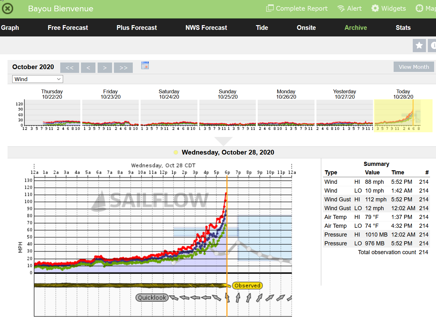
8 minutes ago, cptcatz said:
The radar loop looks like the eye is moving north of northwest and is on track to make a beeline for downtown New Orleans.
Yeah, I've been watching this for my old hometown. This latest jog is looking more like a heading I fear.
-
All this power outage talk makes me think I'm in my SE forum with .10 of ice accretion in the forecast.
-
1
-
 2
2
-
-
If all I had was a radar and a thermometer I'd be out buying milk and bread after peaking at tonight's SE radar. Dang, can't break this snow drought here.
-
So does 1/10th of an inch count as a White Christmas? It does here!

-
4 hours ago, Orangeburgwx said:
Ugh, accidentally sent the mean twice, here are the individual ensembles

Sent from my LGL322DL using Tapatalk
So what's with the "banding" look to all of these members? 3-4 distinct ares of enhancement of anafrontal snowfall. Is it weak distinct disturbances riding up the front, or temp driven with time of day? Weird look.
-
3 minutes ago, Calderon said:
Camille was a lie and we all know it.
Whatever. I was there.
-
2
-
-
Camille 2. 901mb 185mph
-
5 minutes ago, Prospero said:
We might get a week or two before the next LA hurricane...
Why not? There is a patch of untouched water in the Bay of Campeche.
-
1
-
3
-
2
-
-
1 minute ago, Prospero said:
Few minutes ago:

Dang. I grew up there. I should have chased this one.
-
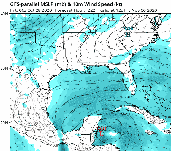
After a lazy day recovering from its trip across the Yucatan, Zeta looks to be beginning to fire some convection around the center.
-
Does anyone have the EMCF and GFS gust products handy? Zeta looks to be likely to cause more inland tree damage deep into the SE states than any storm this season given it's fast forward motion once inland.
-
Come on people. It's not maxing out until it nears landfall. 2020 remember?
-
1 minute ago, wxmx said:
Would be quite a feat, being inland
") ... but yeah, it looks like a bona fide TC around 22.2N
... but yeah, it looks like a bona fide TC around 22.2N
LOL. I always thought mountains were the place to be. 95.5w
-
1
-
-
Sure looks an awful lot like we have a tropical storm near 22.3n 99.5w on satellite to me.
-
3 minutes ago, WxWatcher007 said:
I think recon has found enough to declare this a hurricane. Unflagged hurricane force SFMR and FL winds.
Marco is looking rather frisky on satellite too.
-
1
-
-
Huge eastward track shift on 12Z GFS. Brings it into SE Louisiana.
-
1
-
-
Thankfully, this didn't work out so well here:
Special Weather Statement
National Weather Service Peachtree City GA
353 AM EST Sat Feb 8 2020

GAZ027-036-037-041>044-046>048-052>057-066>068-082100-
Madison-Clarke-Oconee-Haralson-Carroll-Douglas-South Fulton-
Rockdale-Walton-Newton-Heard-Coweta-Fayette-Clayton-Spalding-
Henry-Troup-Meriwether-Pike-
353 AM EST Sat Feb 8 2020

Rain mixed with snow will be possible during the early morning
hours. Temperatures at that time will range mostly in the upper
20s to lower 30s. It is possible that a brief period of freezing
rain accompanies the precipitation which would create some
traffic concerns. No accumulation is expected as temperatures
should gradually rise into the 40s by early afternoon bringing a
transition to all rain.
El Nino 2023-2024
in Weather Forecasting and Discussion
Posted
What to make of the big positive spike shown at months end before most of those members fall off of the cliff? That's new.