
Stx_Thunder
-
Posts
204 -
Joined
Content Type
Profiles
Blogs
Forums
American Weather
Media Demo
Store
Gallery
Posts posted by Stx_Thunder
-
-
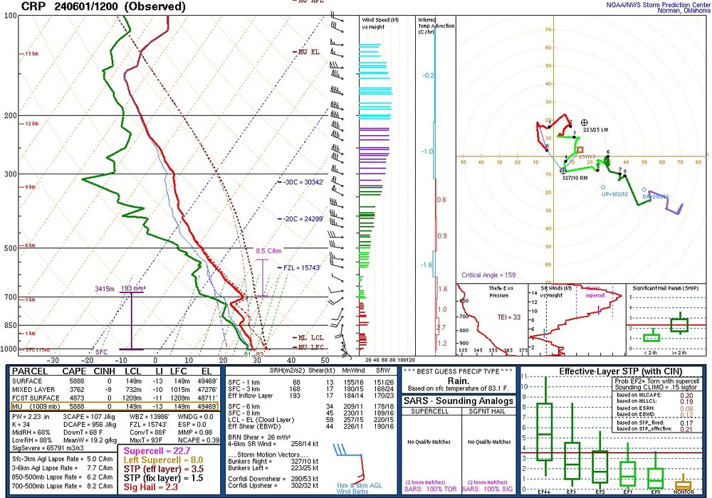
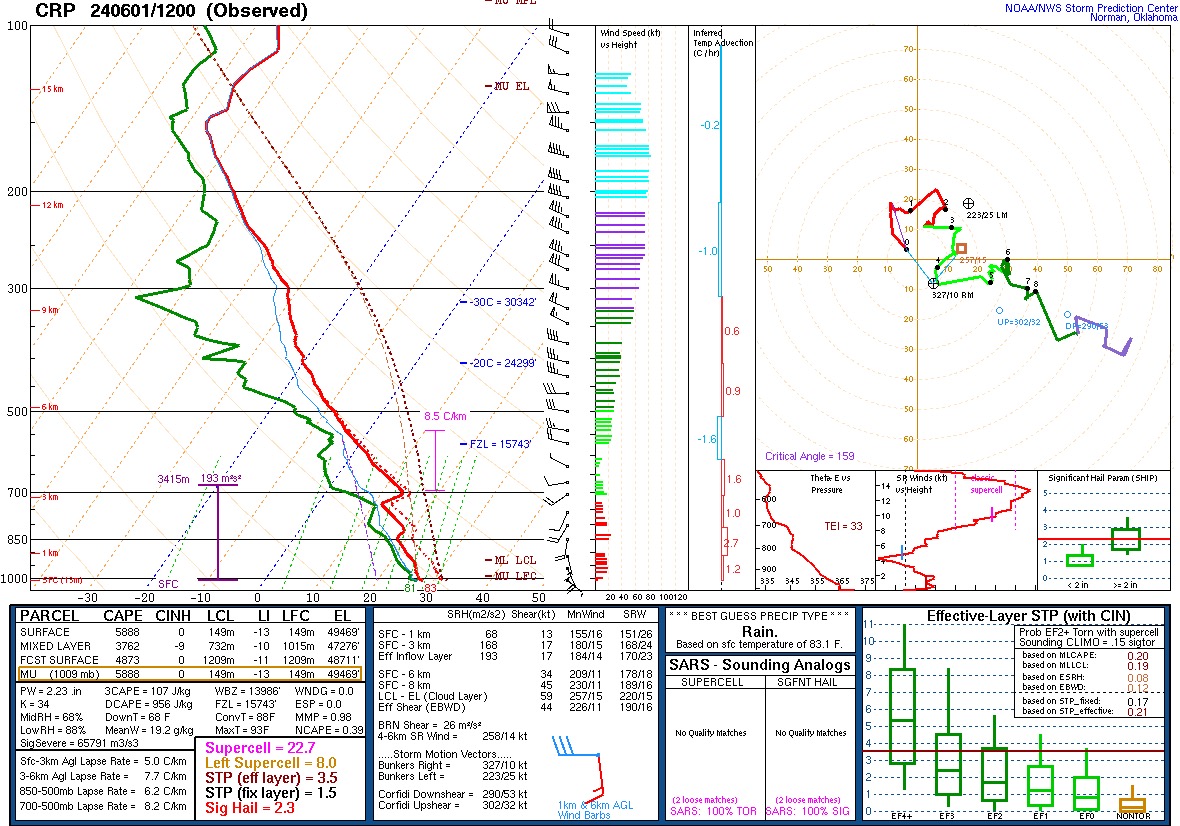
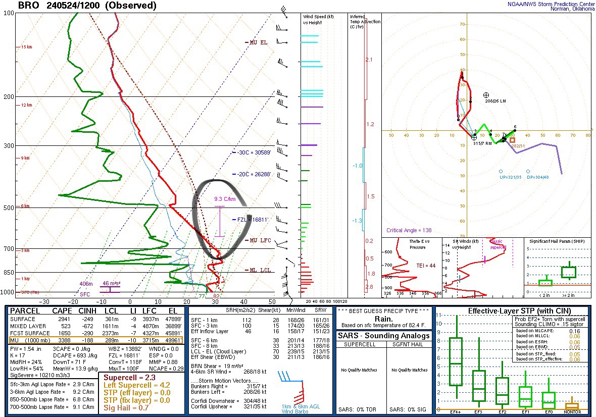
12z CRP obs sounding this morning is convectively primed with a P. Only caveat is a bit of 700Mb warm nose.
- - -
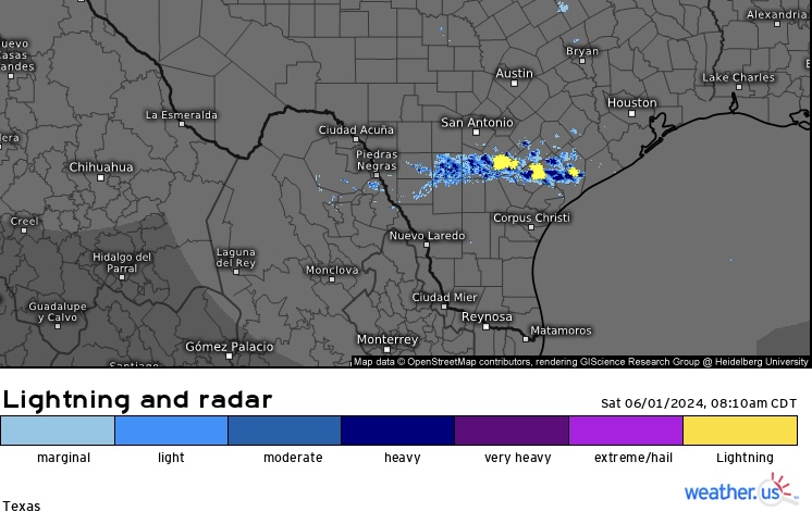
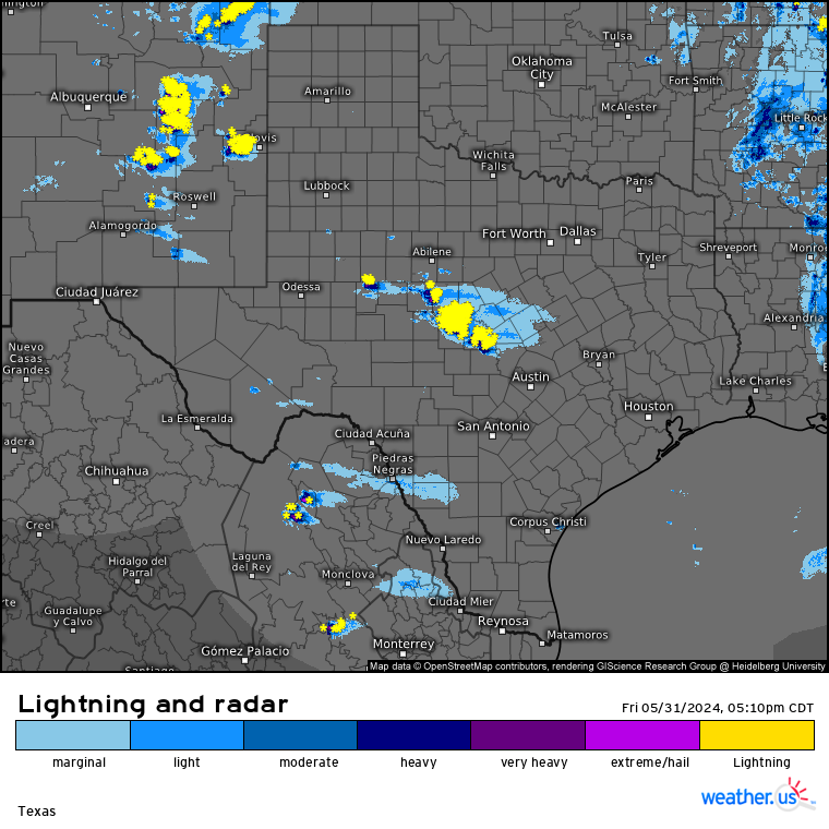
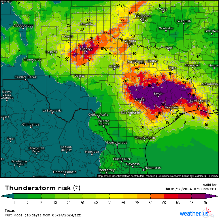
Will see how much of that built-up energy is realized today/night, but already seeing a line of cells popping up fairly quick in the past hour just south of San Antonio - near Victoria, with an outflow coming from the overnight upstream MCS activity in the panhandle and western hill country.There appears to be a decent mid/upper shortwave approaching the region from the west on 12z UA compiled data on SPC this morning also (decent area of 300Mb divergence just west of middle Rio Grande).
-
11 hours ago, cstrunk said:
I'm looking forward to some drier weather, I need to mow my lawn!
‘Really kind of doubting that’ll happen for at least the next 2 weeks. Especially over NTX/ETX where there’s been lots of convective stuff going on quite persistently since end of April.Even starting June now, there’s still lots of significant influence from SS still in place over all of the state. Which isn’t typical on summer’s doorstep now. Especially down around here.
Models (especially Euro & ensembles) just got way too excited on the typical, controlling furnace 500Mb High this time of year really taking over the state a few weeks ago. And we’ve been basically getting the exact opposite of that.
-
 1
1
-
-
Watching evolution & southward progression of the new MCCs ongoing in the hill country (northwest of Austin), and in NM going into tonight, as of typing this. Looks to definitely effect San Antonio area this evening or overnight.
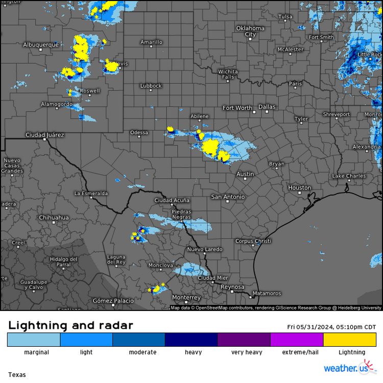
- - -Got a strong outflow front from the MCS moving through Houston area and out over the Gulf earlier this morning with some 50 mph gusts and heard some nice CGs, along with some more modest rainfall.
Things are probably too stable now over NTX - SETX for much of anything else through tonight from this morning’s sharply organized system. But would think it’ll pick up again in those regions by later tomorrow/night. Especially with some better ML shortwave energy projected to track through the state at times this weekend on both Euro & GFS.
-
It’s been a fairly busy week for me, but did cash in on Tuesday night’s MCS from the western part of state that had a grade C+ overall, thunder show around me with some pretty frequent lightning for an hour. Not a lot of CGs though. But was nice either way. Especially before an embedded deep convective band came over me with almost constant thunder rumbles.
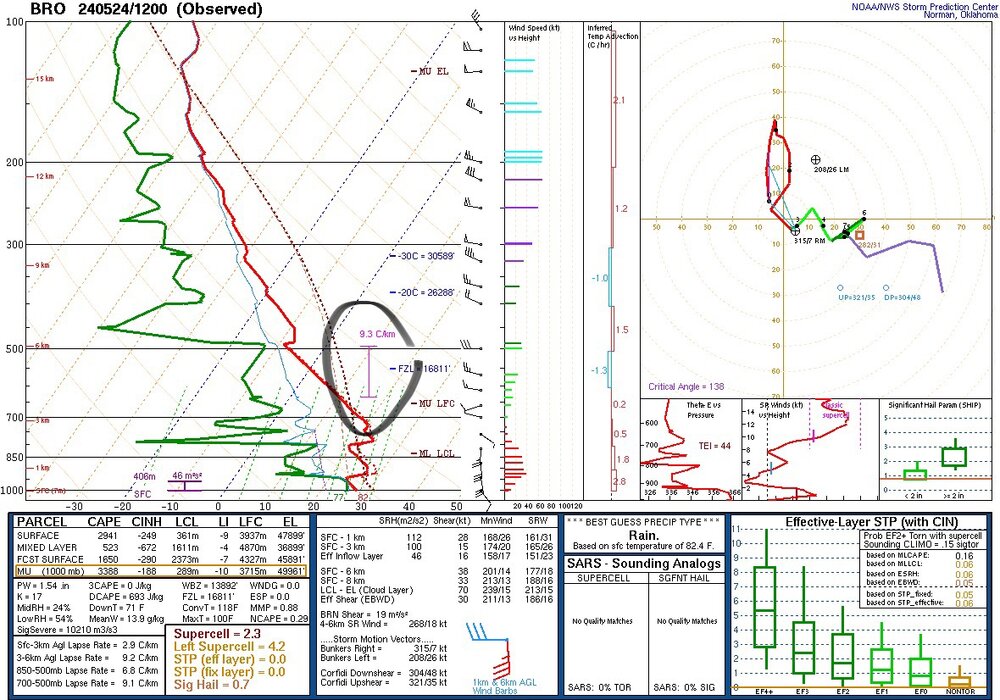
Watching hill country linear MCS near Austin (or its effects further south later today/tonight). Shear & instability values are still pretty high around here (50 kts eff. shear & still abnormal 8 C/km ML lapse rates, and no-brainer CAPE/moisture on 0z BRO & CRP soundings). Main svr threat (if any) with ongoing hill country MCS early this morning looks to be wind with its notable linear orientation.
These practically unlimited MCSs tracking southeast through NWTX - NTX are tracking faster and further southward now into the state with increased west-northwesterly ML flow (which should mitigate a sig flood threat also). It’s almost literally been becoming one MCS after one MCS after one MCS in the northern part since the last 2 or 3 days.
No complaints from me as long I get in on some of that trailing thunder action into this weekend. Models also showing some stronger ML shortwave energy here & there tracking through the state this weekend as well.
- - - -
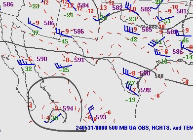
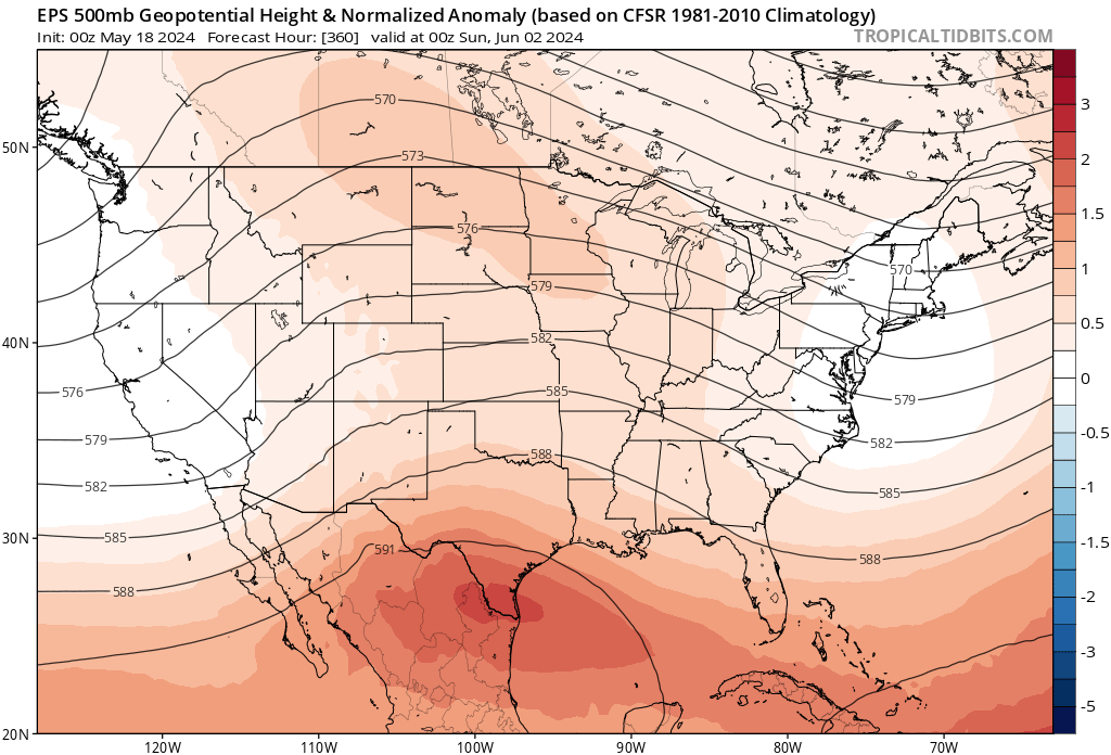
Also, ‘really liking those projected H5 heights on GFS/GEFS the next couple days or so (even into second week of June). The furnace High is pretty far southwest of the state now, and not really strong either (seeing 594dm over western Mex). The 588dm line is pretty close to me now as well. Which thankfully, is pretty good this time of year.
-
1 hour ago, Quincy said:
I know it’s early, but this whole complex could grow upscale and impact the greater Houston area later on…
Knowing well over the years how MCS activity goes this time of year in TX, that’s bound to happen as it very rarely fails around Houston, especially. But the same (concerning impacts) could be said for a large part of the state later today.Though especially now with daytime heating coming into the mix (aside from adequate CAPE & shear). And the H5 subtropical High is moving further west away from TX as I got an almost due-northerly 500Mb flow now on 12z (BRO & CRP) UA sounding data here in STX this morning.
-
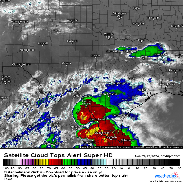
There were some pretty cold storm cloud tops on satellite earlier tonight near lower Rio Grande as the MCS activity was about to get into deep STX. But especially the MCC near Laredo off to the west (colder than -80 C tops).
Still some uncertainly in convective & severe evolution later today (especially because of likely numerous outflow interactions in CTX/NTX ). But overall, the environment aloft over much of state is still looking pretty favorable and there will likely be enough shear either way for supercells & stronger/severe clusters or segments.Saw near 3” in. hail indications an hour ago on new individual storms ongoing over TX/OK border near/north of Wichita Falls (will likely consolidate into another MCS that’ll likely determine today’s severe for ETX/SETX during daytime today).


- - - - -
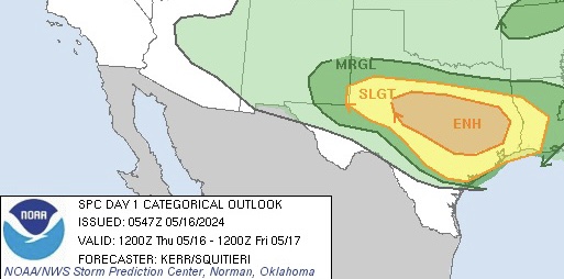
16 hours ago, Ed, snow and hurricane fan said:SPC going enhanced for Central Texas. 3 kn NAM forecast soundings on I-35 in Williamson County at 6 pm shows 'meh' shear, but 4000 J/Kg MLCAPE and 1400 DCAPE. SPC also extended SLIGHT to NW Houston suburbs, not mentioning cold pool propagation directly but stating storms in this situation frequently move faster/further than modeled. EDIT TO ADD: this time last week ensembles suggested that spring was over south of US 84.
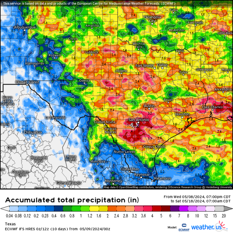
Models & CAMs never do really well this time of year with especially large MCS evolution & propagation around the state (especially into southern half & coast).Euro/EPS just wasn’t realistic with H5 heights to begin with. Especially still being very early in the hot season. Outside of convective forecasting, I don’t trust Euro anyway when it comes to temp/height related things at all. Even with cold fronts.
GFS/GEFS does better overall concerning those kinds of longer range forecasting things.
-
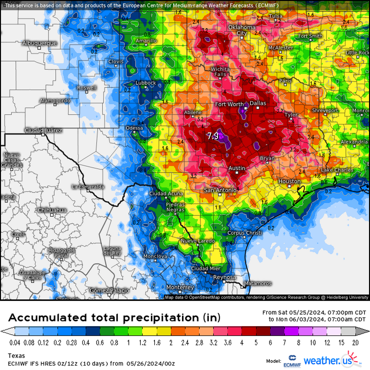
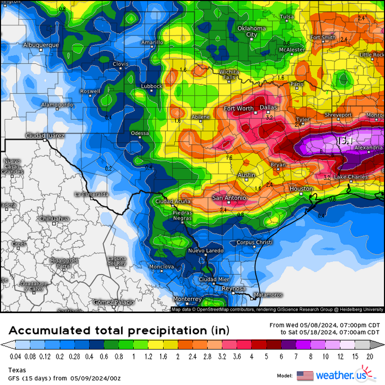
Both GFS & Euro been showing stronger and stronger signs of the furnace 500mb High weakening & moving further southwest away from the state a bit this upcoming week (could stay that way into at least the first week of June also which could increase flooding potential again in NTX/ETX as both models also trending upward on rainfall totals into beginning of June).
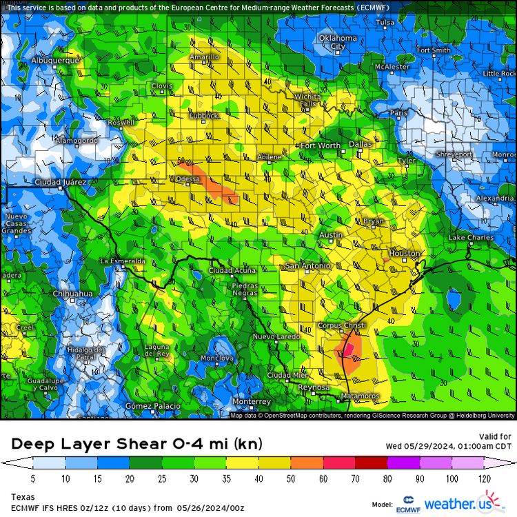
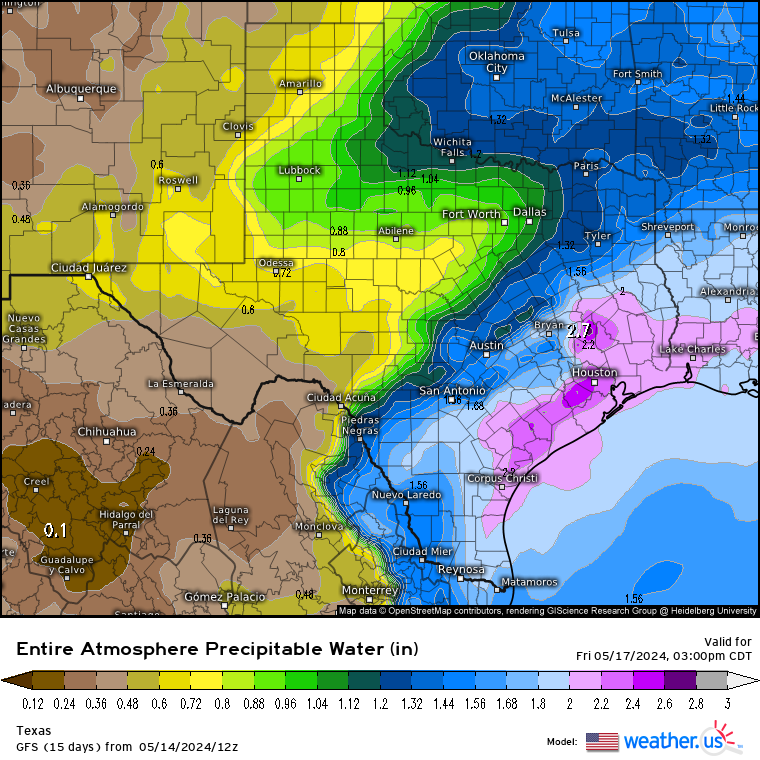
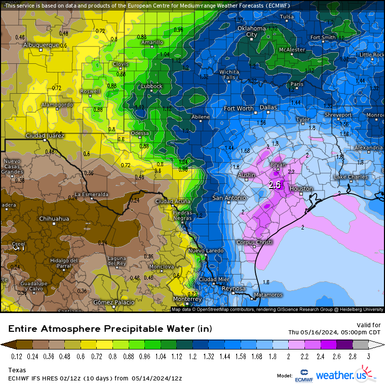
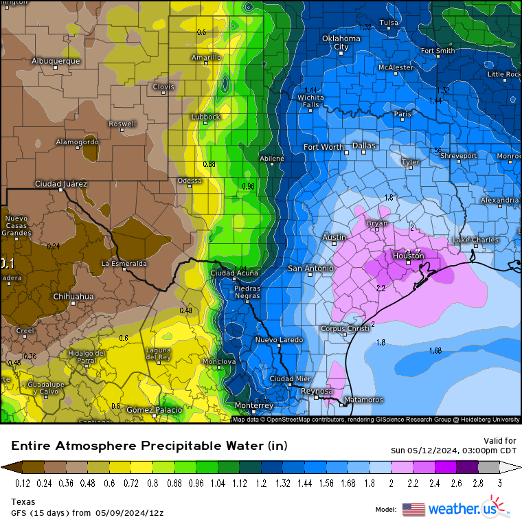
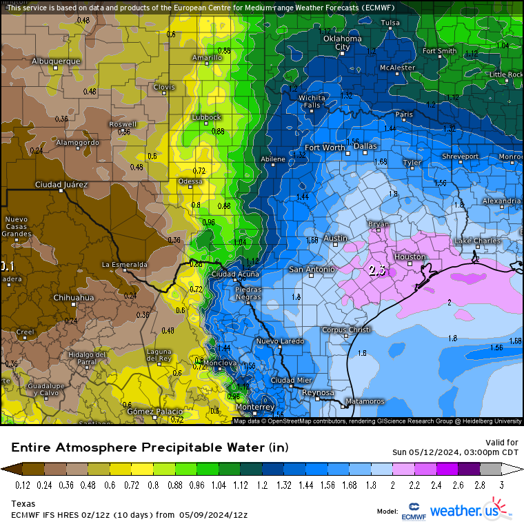
It’s definitely looking more convectively interesting with likely, better or bigger MCS activity propagating farther south (including into STX with some heavy rainfall with 2+ in. PW projections which is easily achievable by this time of year), starting later on Memorial Day. But particularly Tuesday - Wednesday and late this week/end, as there’s very notably steep ML lapse rates, along with DL shear 40 - 50 kts projected over a good amount of the state.
Both still abnormally high in late May now.
- Saw ML lapse rates on Brownsville 12z sounding two mornings ago on Friday, of 9+ C/km.Definitely steeper than normal down here in late May (even 8 too). No doubt about that.
On 5/18/2024 at 3:32 PM, Ed, snow and hurricane fan said:From about US 84 and S, it looks to get rather dry and quite warm. I think this is the beginning of summer in STX and the next real chance of significant rain is August, more likely September. Not sure the STR ever gets far enough N that we'll see inverted troughs breaking off from the jet and coming back W under the ridge. Land of pure speculation, next best chance for significant weather is probably in September when the STR breaks down enough for the return of rain producing fronts (not the weak wind shifts with small dewpoint drop that can make it here even mid-summer, but don't produce sensible weather because of high heights and subsidence.
Good news, for customers whose 'weatherheads' (pipe that carries electric down to the house and external breaker box) aren't damaged, CenterPoint thinks most customers will have electricity by Wednesday. Which will be a good thing considering the heat. Low 90sF all week with dews above 70F.
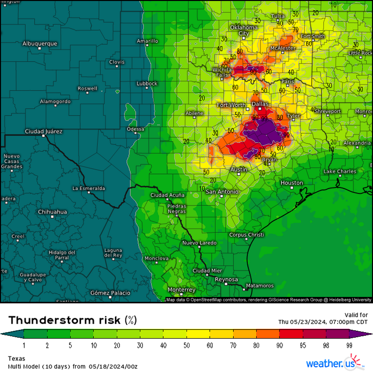
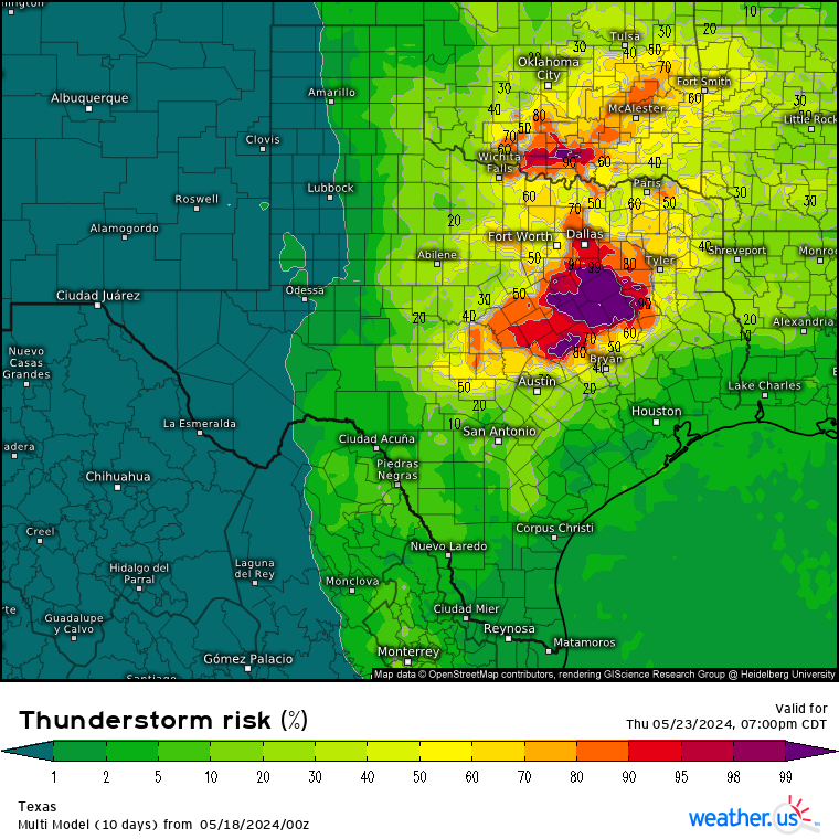
OTOH, in NTX, DFW is already in a 15% risk for severe storms on Thursday. They have probably 2 more weeks of spring before the high heights shut down spring.

You may want to keep in mind that South TX can actually get upstream MCS activity typically through about mid June. Especially with SS flow influence still in place in the mid-upper levels (as has been the case many years during past 2 decades).It may be officially summer at the surface around here (that’s always typical by later May in STX). But that isn’t normally the case aloft most years until the latter part of June.
Was not convinced last weekend on EPS H5 height projections for the end of May as it was wobbling around on runs and going as high as almost 600 dm. Which just isn’t plausible so early in the hot season. Even in STX. Especially with EN influence basically gone now. GEFS was more consistent, and SPC daily observed UA 500mb data down here during this past week has been much more closely reflecting GEFS H5 height prediction from last week (staying around 590dm which is pretty close to normal in STX).I’m very convinced now we’re not going to have the kind of hot/dry persistence of Summer 2023. At least around the coastal region. With LN creeping back, there’ll likely be some more tropical activity also later this summer. But doesn’t translate to a hurricane for TX coast this year. Especially coming off a very formidable EN phase just this past winter - spring. That’s never happened before on climate history the past couple decades.
-
1
-
-
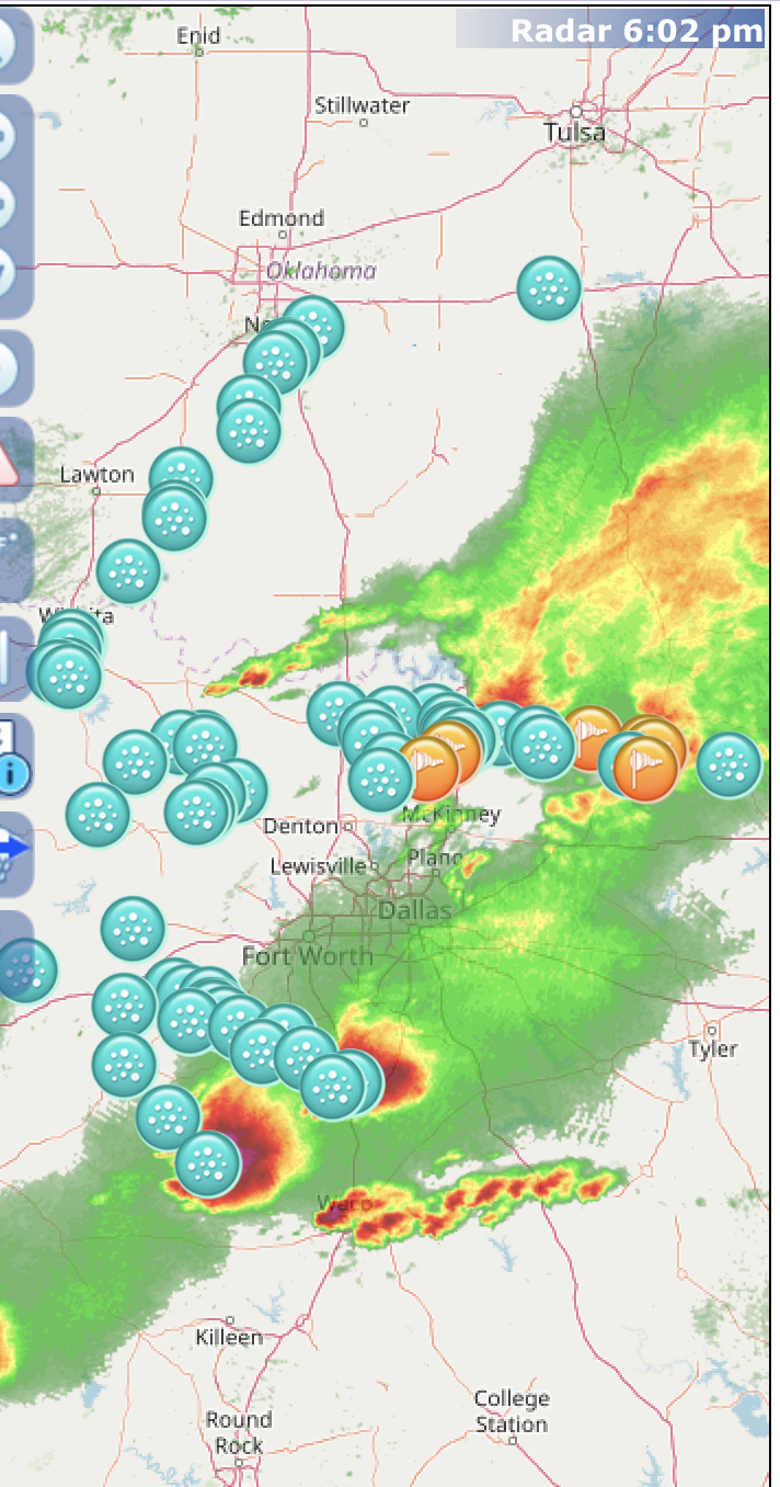
1 hour ago, Chinook said:
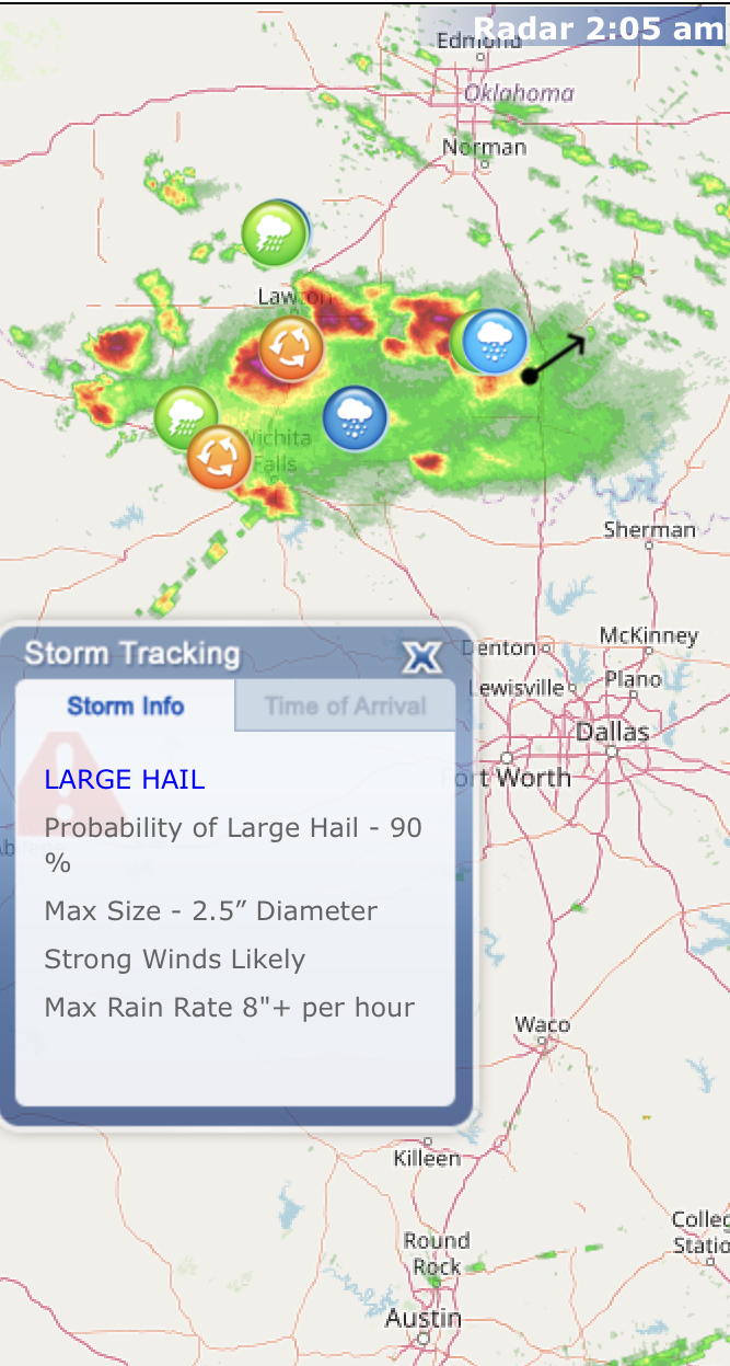
Maybe some of your friends got this large hail
I don’t see any actual large hail there (2+ diameter), except maybe that icon that’s blocked out on the left side of the warning outline box. -
On 5/17/2024 at 6:16 PM, Ed, snow and hurricane fan said:
Rain is ~10 miles away, near downtown by radar, but was outside, bright CG lightning, less than 3 miles away judging by the thunder.
Got my share of a very decent thunder show & rainfall down here through daytime morning hours Friday (yesterday). Had one severe warned mini cluster (provided some good convective blowoff shield lightning strikes during the couple of hours prior), near me around noonday from the southwest that had literally no CGs around when was it was about to come over, then BAM! (almost literally)Had a feeling that was gonna happen. Was pretty bright, inside. Even though didn’t really get dark outside right ahead of the cluster. Nowhere as crazy dark outside as what happened in Houston on thursday. Rain rates in the cluster here were definitely over 3”/hr. Definitely an inch total yesterday.
Power went out for about 3 seconds. Saw it was a fairly powerful negative CG on lightning analysis (150 kiloamps).
- - -
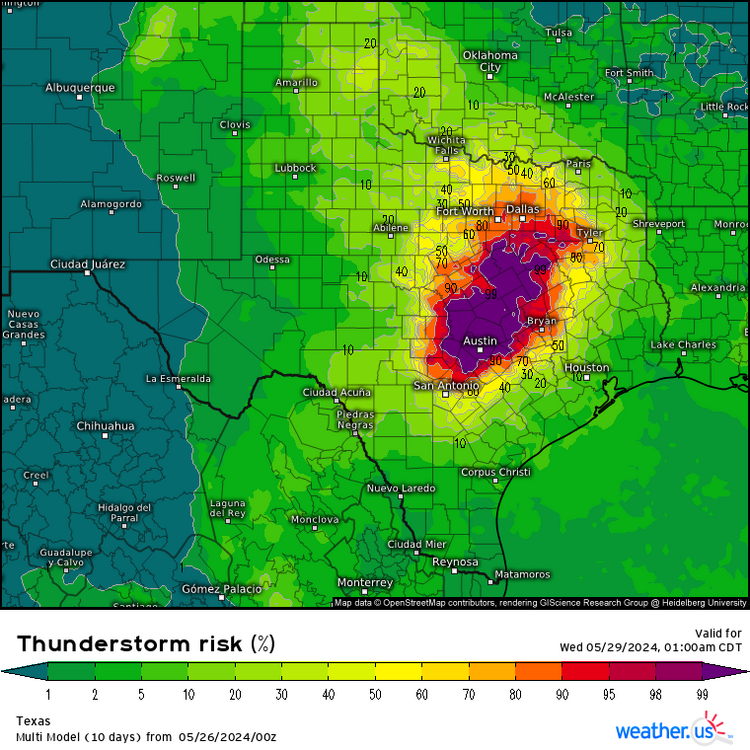
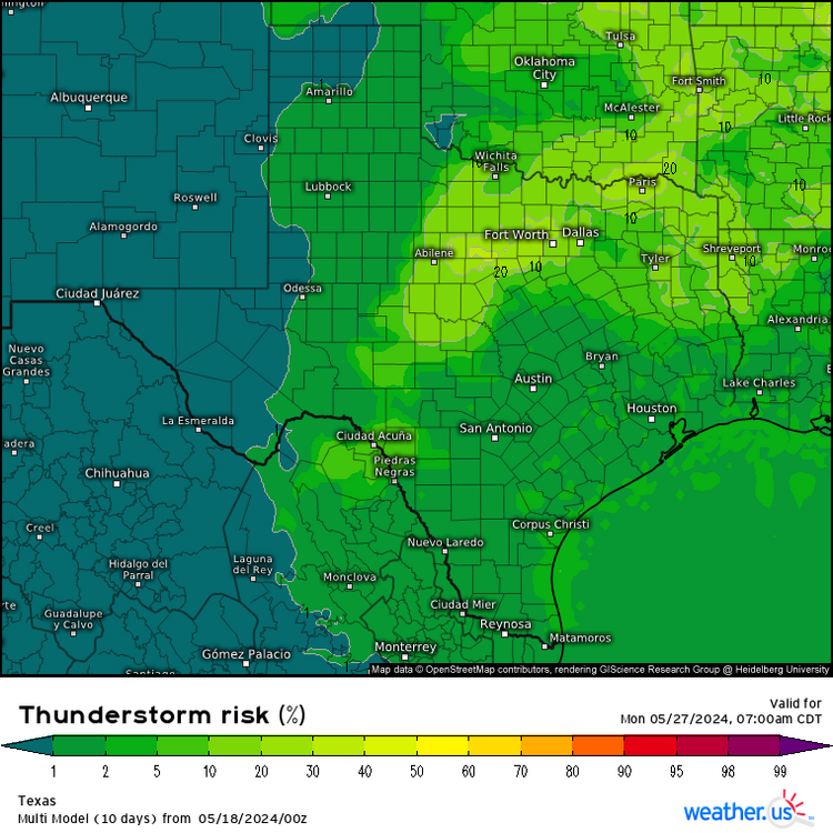
That looks to be about it convective and/or MCS wise for the state till Thursday (upcoming week). And possibly again by Memorial Day (seeing a solid “higher” probability signal area again in NTX).
Not seeing a strong signal for continued sig flooding potential in ETX & especially closer to Houston area.
With all the dry, very warm/hot days ahead into the upcoming week on GFS/Euro, ETX should be able to dry out fairly well. Flood-producing MCS activity later next week doesn’t seem likely either unless there’s a growing signal on models in coming days for things to really pick up again Memorial Day weekend into final week of May. Which is fairly possible as the furnace ML High doesn’t look like it’s going to hold really strong over the state as I see latest GFS runs have backed off on 500mb heights some for coming week.
Both GFS & Euro holding mainly steady around 590dm @ H5 in STX all week. Which isn’t too bad around here by this time of year.
-
10 hours ago, cheese007 said:
Windows blown out downtown
It’s MLB season. The Astros were just playing as scheduled tonight at Minute Maid ballpark, and it looks like they’re gonna win also which is a nice finish to today’s powerful convective action in Houston.Nothing severe there lol
8 hours ago, Chinook said:This is measured by downtown-- 62 knots ( Houston Dunn Helistop airport?)
62 kts seems on spot around Houston as most people can definitely lose power at those sudden gust speeds (at least around this part of the country).
But the TDS signature on radar and the broken windows on those 2 downtown skyscrapers that @cheese007 posted about suggests there may have been a very brief spinup right around there as the thunder line was moving in (on the leading edge).
-
1
-
-
4 hours ago, Torch Tiger said:
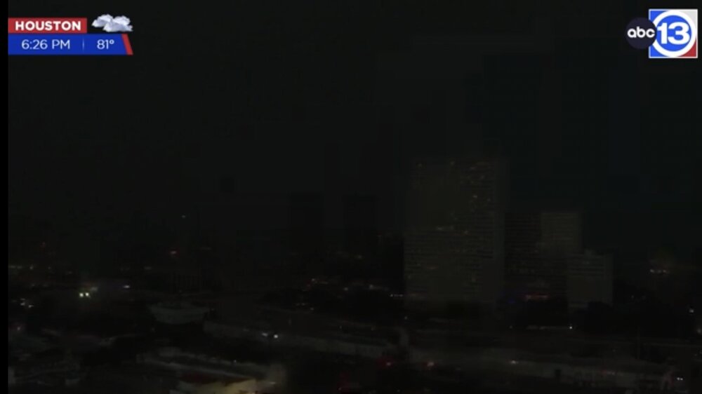
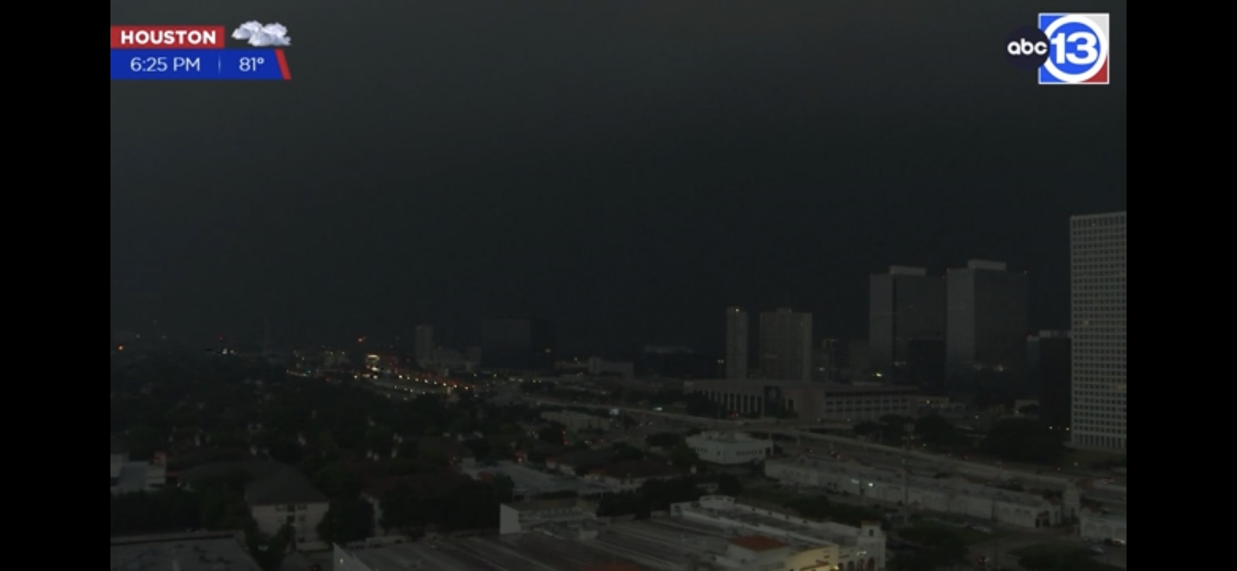
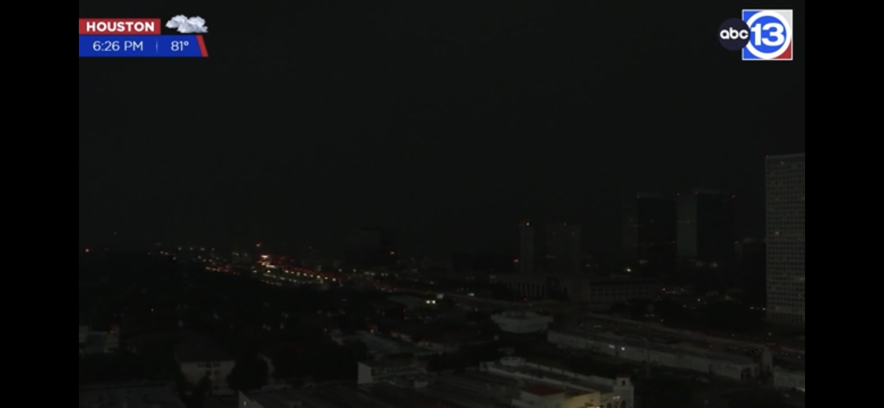
I've been watching webcams, very familiar with SE texas. Big hit, many webcams down and that's rare. Looked wild.
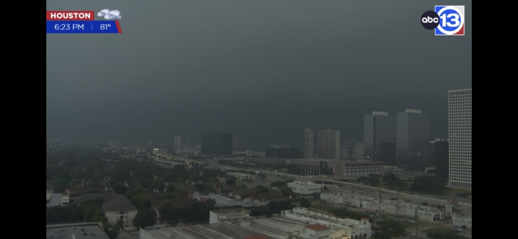
The ABC13 tower cam in Houston survived the convective wind onslaught from what I was seeing on the YouTube livestream just a short time ago now that the line has moved off.
The live rail cams (with audio) like this one seem to have gone out as it’s still just replaying the stream when the thunder line was moving through the metro:
https://youtube.com/watch?v=Uqq-1HPjJ2o
I thought it was my connection though. But power went out for those railroad cameras in the city from what I’m seeing in the live chat.
-
1
-
-
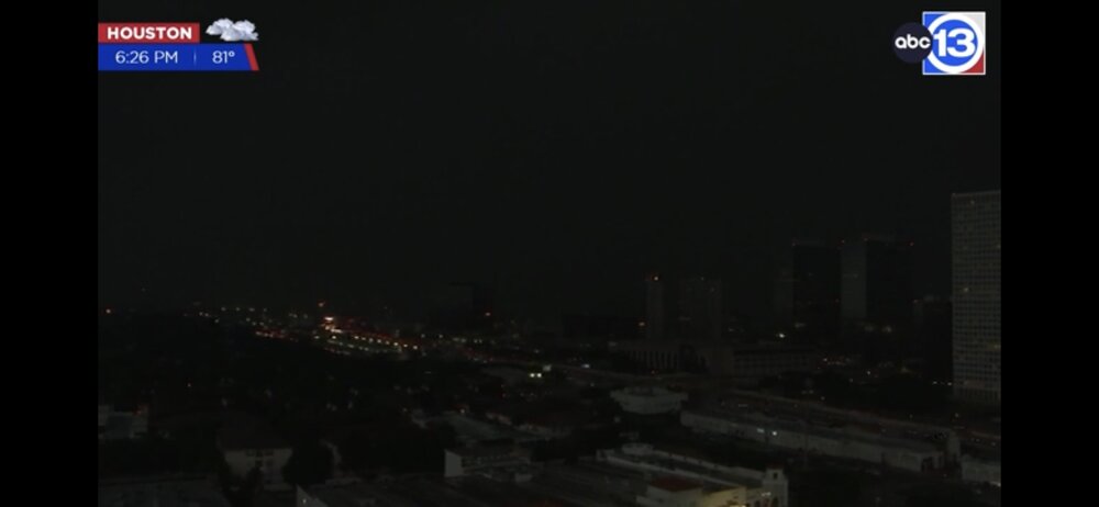
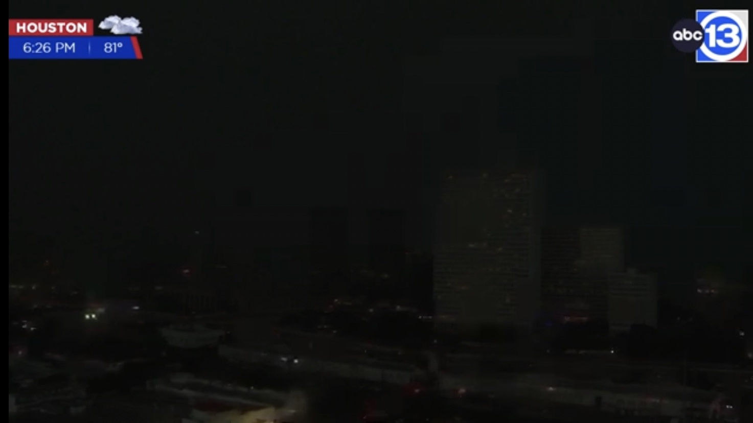
Was watching the front edge of the convective line from the west about to get into Houston on ABC13 tower cam live stream a short while ago.
It was already very cloudy ahead of it, and then it literally got DARK in just a matter of minutes when it came in. Saw a few power flashes also. I’m almost sure it was straight line winds seeing how it looked on this tower cam that faces southwest - west.


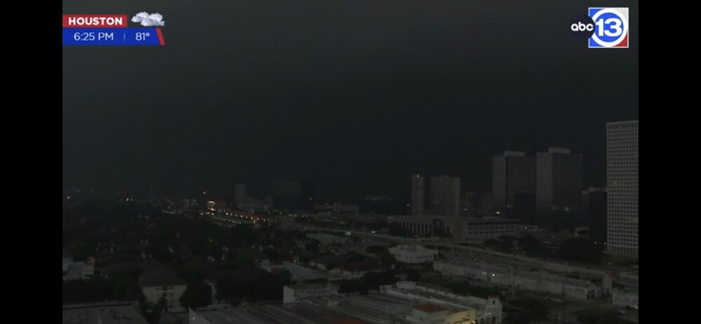
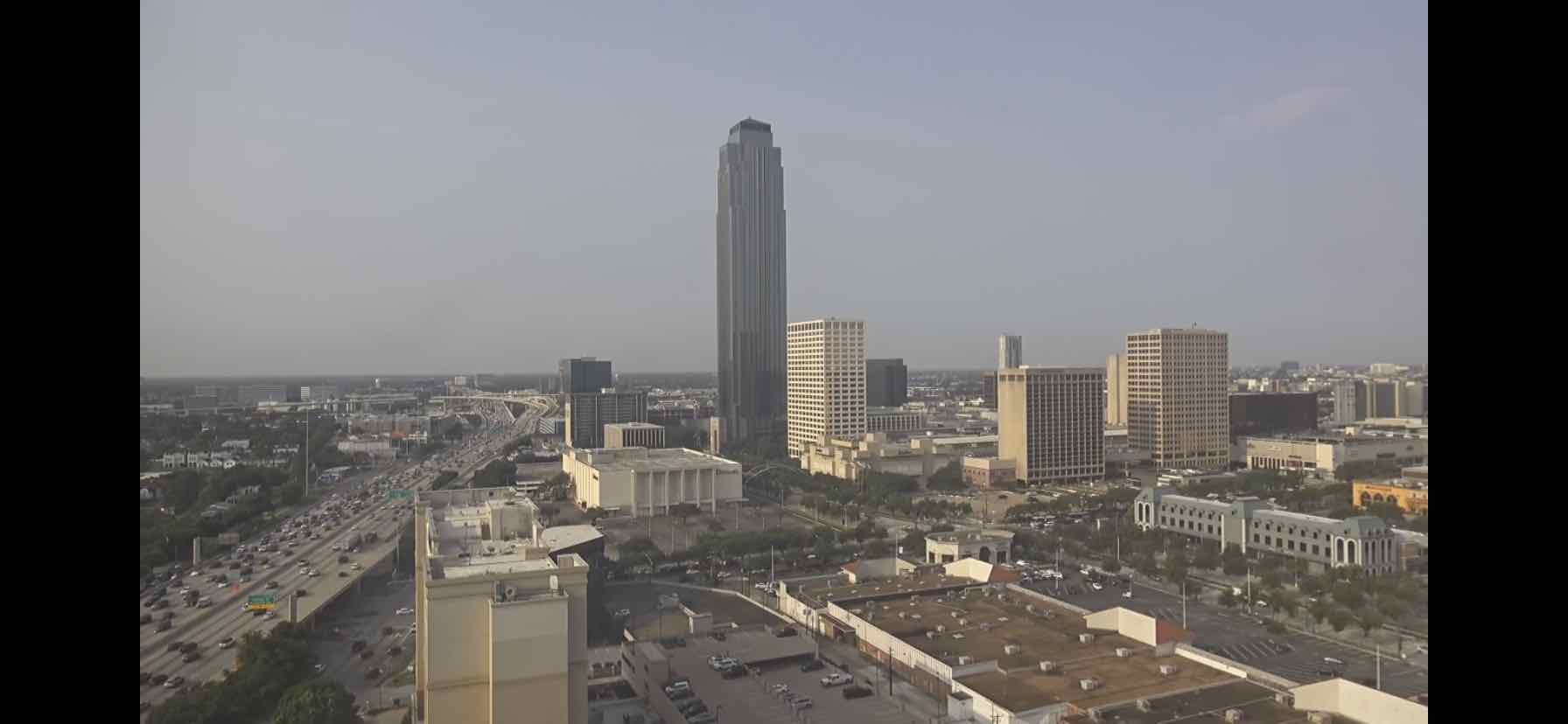
- Crazy how it went to that scene after how it looked at 8:40 am today on Houston uptown Earthcam.https://www.earthcam.com/usa/texas/houston/?cam=houston

-
https://www.wpc.ncep.noaa.gov/metwatch/metwatch_mpd_multi.php?md=0276&yr=2024
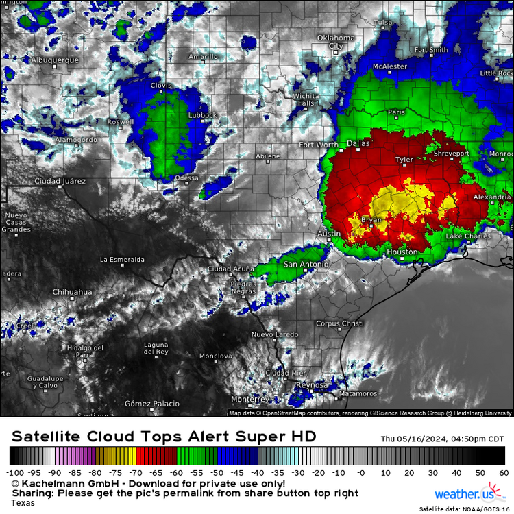
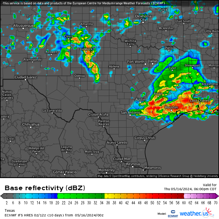
Large, elongated MCS closing in on Houston. Looks fairly impressive over ETX with a good area of -70 C to -80 C cloud tops embedded.
-
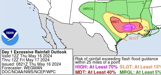
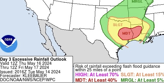
WPC finally going with a High risk area now in ETX. It’s been a good while since I’ve seen any high risk ERO here in TX. Since 2021 if I’m not mistaken.
Currently seeing thunder activity in NTX (west of DFW area) getting its act together going southeast.
Overall and all things considered on models since the past few days, it’s looking pretty busy all-around convective wise for ETX/SETX through today.
-
1
-
-
7 hours ago, Ed, snow and hurricane fan said:
Models are in fairly good agreement that the counties just N of the Houston metro will see the heavy rain. Or, where they need it least, they get the most. HRRR has some areas where the heaviest rain has fallen getting over 7 inches. W of here in the AUS and SAT areas, enhanced for hail seems likely for storms mid-afternoon. Tornado risk as well with fairly high SigTor's on 3 km NAM in the I-35 corridor in Central Texas.
CAMs don’t tend to do well with MCS propagation/evolution southward into southern half of state this time of year (except ARWs at times).Latest Euro 0z run tonight has most plausible scenario for the time of year (May being the most active spring month in TX) and has been doing fairly well with convection since start of year, showing pretty large MCS going all the way down to the upper coast. As long as organized activity is going on in NTX down into ETX earlier today (Thursday), with all the convective/outflow processes upstream the front should be pretty close to Houston by evening.
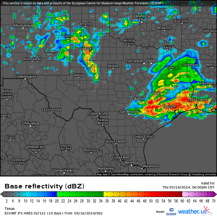
None of the reliable models are showing it but unless shortwave energy tracks much further north or 850mb flow veers more westerly late in the day in SETX, there shouldn’t be any reason why Houston wouldn’t get hit fairly hard (probly Galveston also) as well especially coming in at the right time of day with daytime heating assistance (little/no sfc CIN) also before the event is over around there (or offshore and/or in LA state) by late evening.
- - -
It’s looking dry now for most of state Friday with the front further south except down here (but everywhere for weekend into next week). I should still be able to cash in nicely once more Friday before things really start to dry out. But the growing influence from the typical furnace subtrop High out west next week might not be that strong or long-lasting as even latest GFS runs are showing some possible MCS activity later next week, thankfully.
I’m fairly convinced now this summer, not going to have the kind of hot or rain-free persistence like last summer (except maybe NTX). Especially with any kind of EN not in the cards the rest of this year.
-
On 5/15/2024 at 5:44 AM, Ed, snow and hurricane fan said:
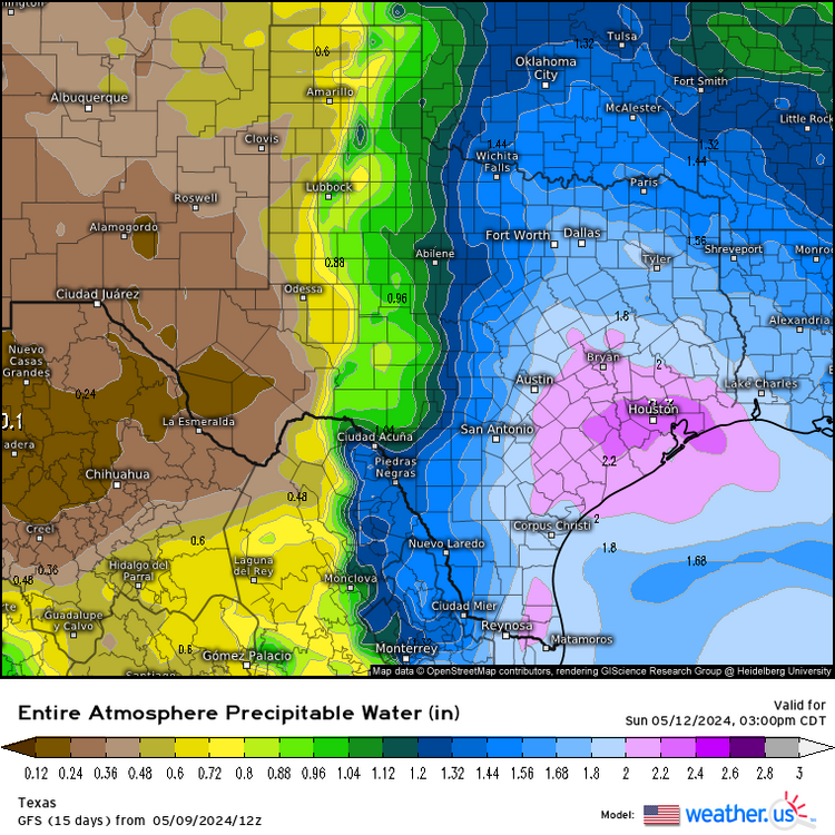
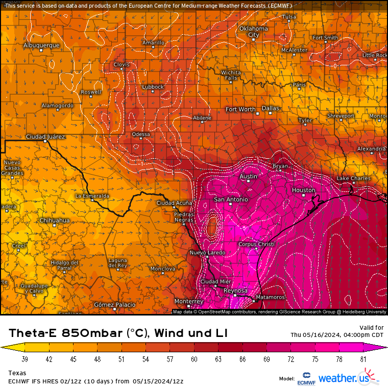
PW that high usually happens in August and is usually associated with a tropical wave. 2.8" is fairly rare, even JAS.
It’s very abnormal either way for mid May standards anywhere in the state.The models might be overdoing the values a little as they’ve trended slightly lower today, but even near 2.5 “ PW pooling south of the frontal boundary (that will be in ETX tomorrow) is definitely still way above normal for this time of year.
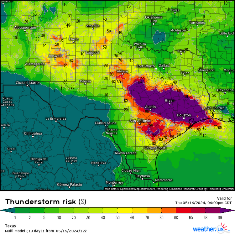
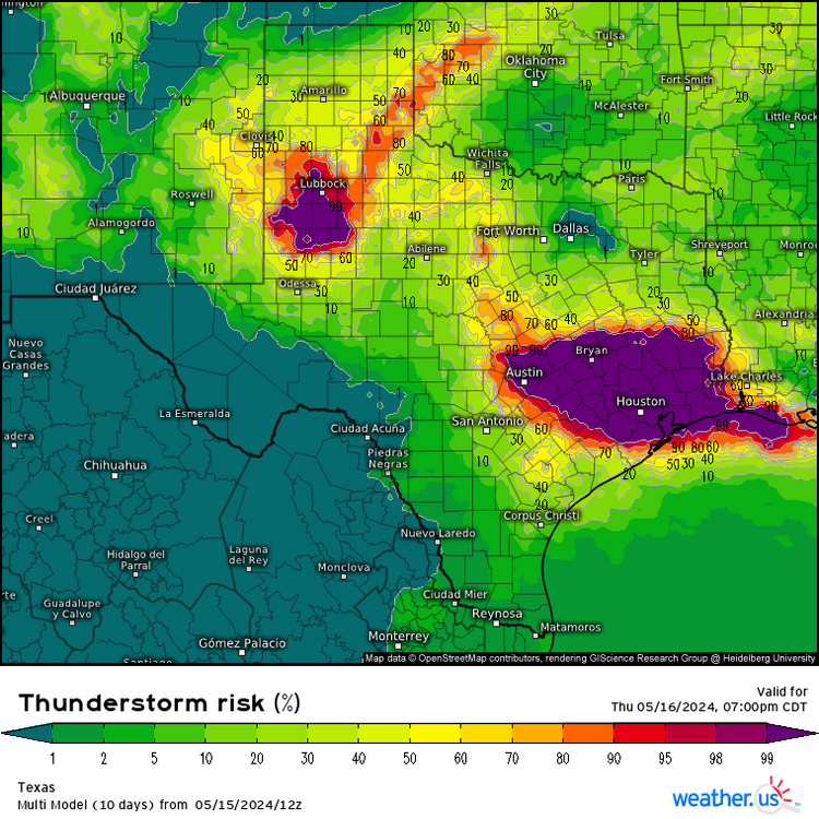
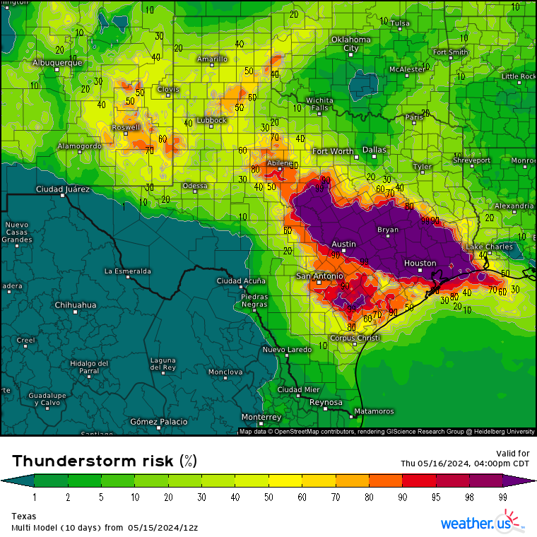
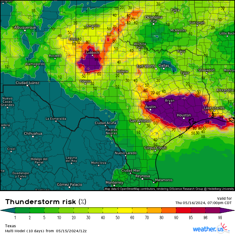
Models & CAMs honing in on convective or more likely MCS action moving southeast into SETX by late afternoon from NTX.
With all the ML energy and surface focus from the frontal/outflow boundaries in the region and mostly parallel storm motion flow to it promoting cell training, along with a decent LL southerly inflow jet from the gulf (pretty strong positive theta advection), could have some actually high rain rates (potentially 5”/hr +), in the strongest storms with PW close to 2.5” further south into Houston and the coast, also.

-
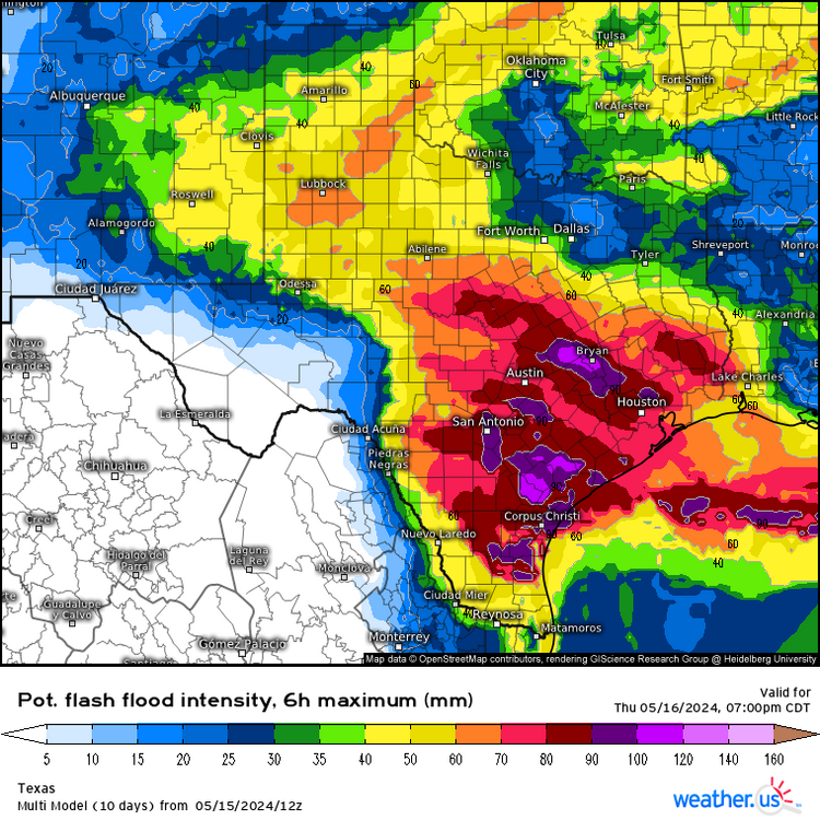
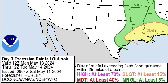
Euro & GFS still trending very abnormally for the time of year, higher on PW Thursday and Friday for SETX (now as high as 2.8 in.). WPC now going with a decent sized moderate flooding risk area on day 3 period today, but also stating a High risk is definitely not out of the question.
I can easily see why as both models are also projecting some pretty strong ML shortwave energy going east into ETX/SETX both Thursday & Friday afternoons. There’ll also be parallel boundary (west-east) storm motions, so there’s likely going to be some cell training involved as well. But it’s very likely there’s going to be more MCS activity in the state at least on Thursday, either way.


-
Finally cashed in on some actual convective action down here Monday. Nothing severe or any hail where I was (despite the impressive sig severe & hail index parameters on 12z CRP sounding Monday morning), but was still a decent thunder show & actual rainfall.
Seeing a fairly good amount of severe wind & hail (a few near 3” diameter) reports from San Antonio area & south on SPC reports for Monday.
Also got that nice little ‘cool’ front (that was stalled up around San Antonio - Houston area) to top it off tonight after all the storms moved offshore before sunset, and got a renewed northwest wind after nightfall.
Slightly lower DP comfort of course, not lasting here after today (Tuesday), but it’s definitely better now outside tonight than it had been literally all last week, but also for a change, no haze from agricultural burn smoke down south (Central America region) like there had been since the start of the month.
- - -
Looks like thunder action will be picking up again in state later this week on Thursday.
I should also be able to cash in again some too as long as the better shortwave energy doesn’t track too far off to my north like it had been the past 2 weeks.
Corpus NWS office mentioned in Monday afternoon AFD, up to 2.5 in. PW around the coast Thursday. Seeing that on latest Euro run tonight, but not as high on latest GFS. But, if 2.5” verifies, that’d definitely be way above normal for mid May anywhere in the state. And would obviously cause more flash flooding. Especially of course, in ETX with such very deep column moisture.
** Edit: GFS going as high as 2.6” PW on Friday.
-
Looking pretty favorable for both severe (hail/damaging winds) & flooding on Monday.
More MCS activity likely over ETX, but especially SETX overall (front will be hanging around there also), with decent DL shear for mid May (40 - 50 kts), instability and support for lift aloft from the next incoming Low into the plains on both GFS & Euro latest runs.
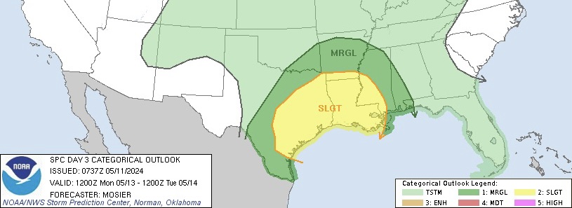
SPC now has fairly large slight risk for eastern half on Monday.
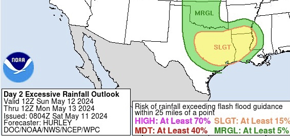
WPC’s ERO has possible moderate risk upgrade on Sunday, but will probably also expand Monday's ERO slight risk to cover most of SETX or Houston area also. Especially with the continued model projection of 2”+ PW pooling ahead of the front around there. Already seeing some evidence of that potential on Brownsville (BRO) 12z observed sounding this morning with PW at 1.98”, where front is currently meandering in deep STX also causing some elevated convective activity as of typing this post this morning.
Other typical storms/supercells are expected to develop out west over Mexican terrain later this afternoon and progress east into hill country and south into STX. But 12z HRRR also showing new development around Houston area overnight into Sunday morning.
- - -
-
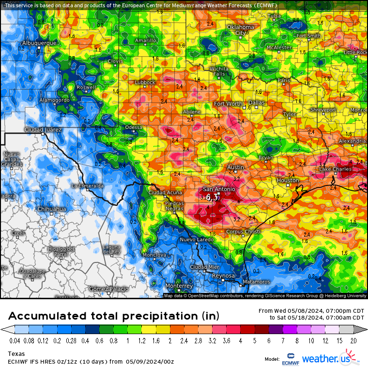
Definitely not dropping the flooding tag (at least for another week or two, possibly not till June). Both GFS & Euro have been stepping up since early this week on rainfall totals for the eastern half with another meandering front involved, into next week.
Not surprised at all as in/out heavy rainfall & flood provoking MCS activity is typical for May just about every year nowadays. Especially coming out of a formidable EN winter and what’s already been going on still only being in the beginning of month.
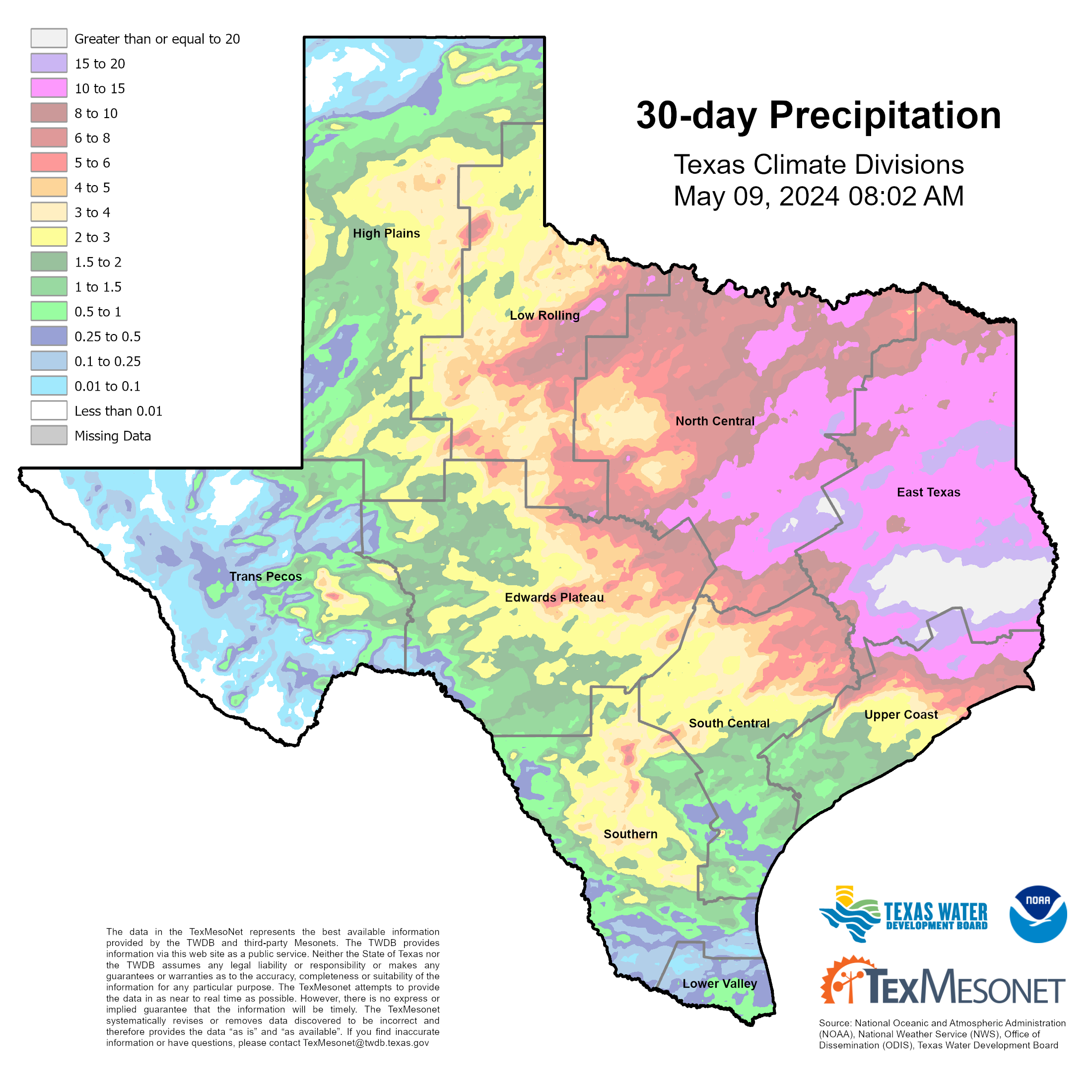
ETX rainfall totals for the past 30 days must be either at or very near 30 inches in some spots (like Huntsville area) now in that > 20” white area.


-
1
-
-
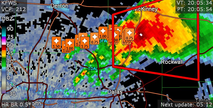
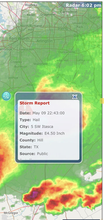
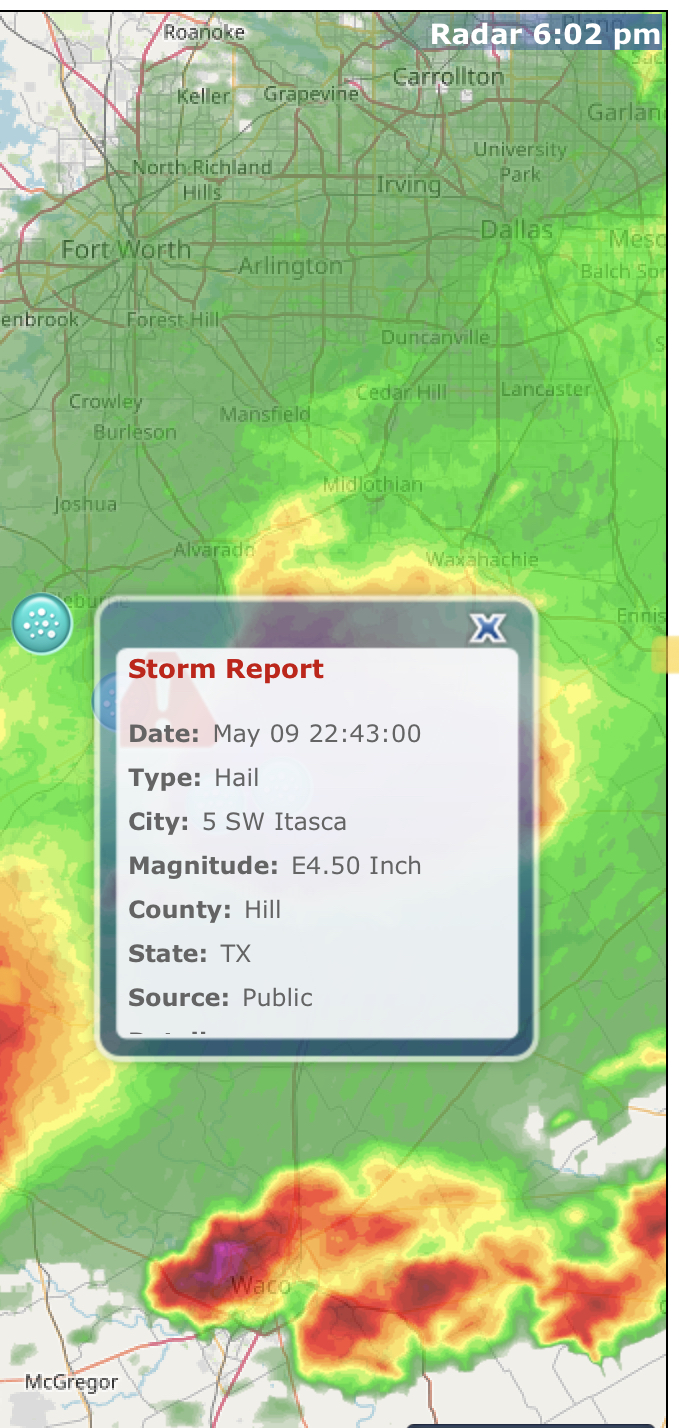
1 hour ago, Chinook said:
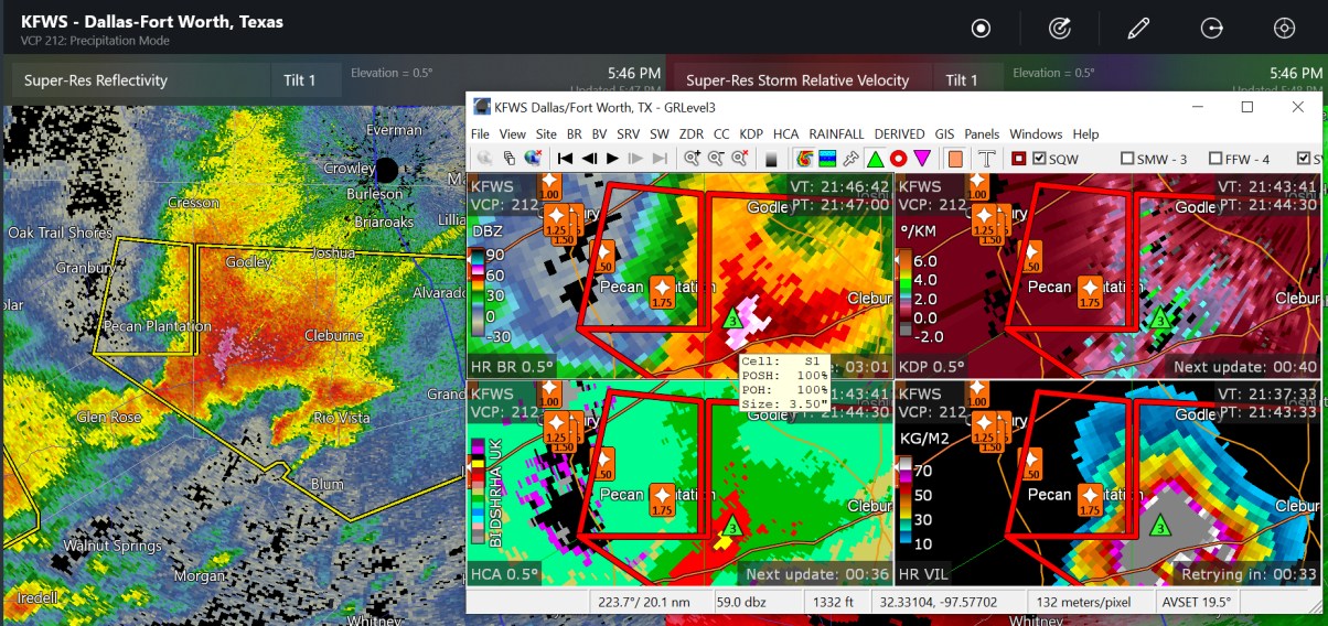
This storm that produced up to baseball sized hail and, more recently, golf ball sized hail.

Possible grapefruit hailer with that supercell that went just southwest of Fort Worth a little while ago.
- - -
Lots of hail reports with basically all kinds of diameter all around DFW area so far today.

2 hours ago, Chargers09 said:That’s just Texas weather lol
Exactly my thoughts when I saw that McAllen temp info post. Nothing unusual there with 100s by May. Even sometimes as early as March in the past.
Not to mention, even Kingsville was easily having that along with HI near 130 last June here around STX.
-
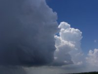
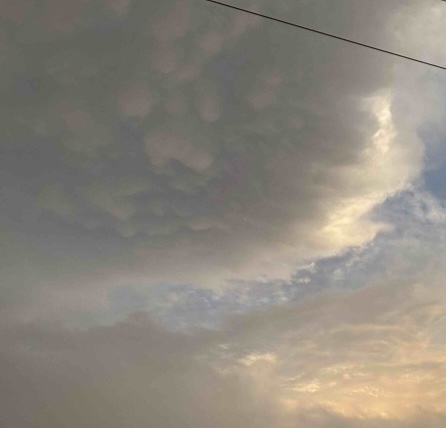
Didn’t see or hear much where I was Sunday afternoon - evening except for 2 decent +CGs nearby outside of all the cells that day. Though I did manage to capture some photo-worthy, near sunset storm clouds off to the south/east as the trailing MCV that caused the storms over the Rio Grande plains & brush country (south of San Antonio), went southeast into deep STX with a last gasp of cells before everything just fell apart at nightfall.
Apparently was mainly day heating-sustained, but did see an EML around 850mb on Brownsville 0z sounding that evening.
Took the photos just after 8 pm.
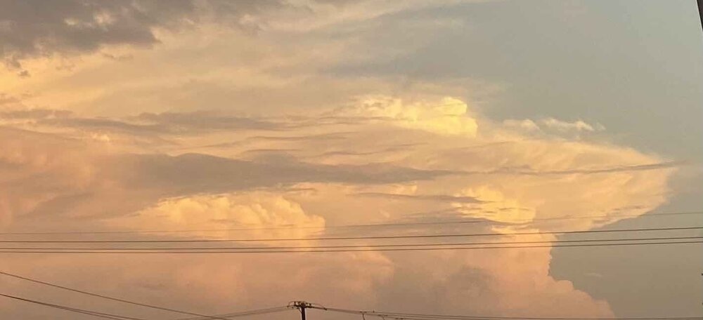
* Saw several CG jumpers (clear air strikes from upper body) about a minute apart from each other on that strongest, rightmost/southernmost cell with the mushroom anvil & overshooting top.Didn’t stay mature like that for long though, and I didn’t even have to look at the radar at all while I was watching it outside with the last of daylight to know it was already having trouble maintaining itself. Both the overshooting top & mushroom anvil flanked out pretty quick after I took that photo. No more than 20 minutes at most.
- - -
-
4 hours ago, WxWatcher007 said:
PDS severe thunderstorm warning for the cell near Norman?
80 mph wind gusts would be the reason if so when I read that warning. Which is considered destructive thunderstorm damage.
I don’t remember if I’ve ever seen a PDS severe thunderstorm warning. But do remember seeing a PDS severe thunderstorm watch on SPC a few years ago (which I also never thought existed and is rare).
-
Heard one very good rumble when some cells popped up nearby a couple hours ago (a good sign for me today especially having missed out on all the convective energy & action up north during this past week).
Watching the cells this afternoon southwest of San Antonio that are currently gathering along the boundary that can be seen fairly well now with all the activity ongoing from Del Rio - Houston.
https://www.spc.noaa.gov/products/watch/ww0186.html
https://www.spc.noaa.gov/products/md/md0639.html
Given these early May afternoon convective scenarios down around here in the past, a few discrete, usually large HP supercells tend to erupt along such outflow fronts and move southeast all the way to the coastal bend before dissipating when they move off the coast. HRRR was also really hinting at that on yesterday evening 0z run.
12z ARW-2 run this morning seems to have a pretty good handle on what’s going on today. Though I wouldn’t be surprised if one or two supercells manage to get down into deep STX also.
3 hours ago, Ed, snow and hurricane fan said:Rain has stopped and the clouds are breaking. Almost full sun in Houston area. I think we get by with only scattered storms the rest of today.
Second round moving into Houston now.
Definitely would not say things are done around there (possibly more organized 3rd or even 4th round). At least until this evening as there’s definitely a boundary hanging around there and another shortwave (causing the new storms southwest of San Antonio) that will be approaching SETX later this afternoon.
-
1
-


Texas 2024 Discussion/Observations
in Central/Western States
Posted
https://www.spc.noaa.gov/products/md/md1106.html
-
Hasn’t moved much and been going on for about 4 hours now in the same area near/around the mid-upper coast.