

metalicwx367
-
Posts
73 -
Joined
-
Last visited
Content Type
Profiles
Blogs
Forums
American Weather
Media Demo
Store
Gallery
Posts posted by metalicwx367
-
-
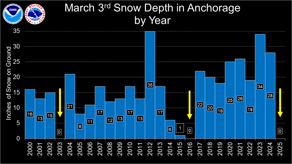
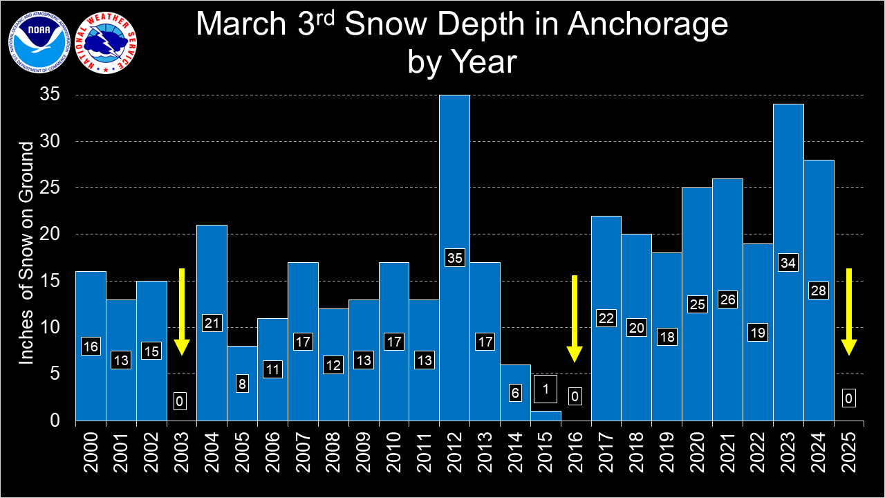
Nearly 3 inches of rain here in my backyard today from that quasi-stationary cell earlier and then a second round 30 mins later. Still constant thunder and lightning outside but majority of the activity is to the south now. Just got back in my hometown today from Anchorage, Alaska so that was quite the change.
-
 1
1
-
 1
1
-
-
On 3/3/2025 at 3:26 AM, frazdaddy said:
Sounds like snow weenie paradise!
Nope not at all this winter lol
-
1
-
-
On 2/25/2025 at 4:12 AM, calculus1 said:
I love Anchorage. Spent a summer there about 20 years ago. Have been back on several summer trips since then. Never experienced a winter, though. Are you in the military? Going to be stationed at JBER?
.Yep that is correct!
-
2
-
-
Last few days in Australia. Getting sent to Anchorage Alaska next. Lol. Well I guess that historic snowstorm in GA last month was just the warm-up for Alaska.
-
3
-
-
2 hours ago, buckeyefan1 said:
Glad you are safely back and isn't that every weather nerds dream?

Haha yeah! Fortunately it looks like it may stay to our east.
-
1
-
-
Wild going from historic snow event in Southern Georgia to nearly a Category 5 hurricane just chilling off the coast of Australia. We will see where this comes ashore but I've never experienced anything over a Category 1.
-
2
-
-
1 hour ago, NorthHillsWx said:
Zelia has rapidly intensified into a beast. Pretty sparse area but there are a few towns that may get hit. Absolutely crazy RI
We are sitting here on the edge of our seats trying to figure out where this beast is gonna go. I've never seen so much disagreement and divergence between models and ensembles in this short of a timeframe. If this ends up tracking further west than expected as some of the ensembles suggest, we are gonna be in serious trouble here in Exmouth.
-
17 hours ago, NorthHillsWx said:
Sad seeing this place die. Was a fun month
It was indeed a very fun month. Glad to have experienced a historic winter storm in my hometown before returning back to this weather in Australia.

-
2
-
 1
1
-
 2
2
-
 2
2
-
-
23 degrees here and clear skies. Still got snow on the ground even after temps in the 50s yesterday. Heading to the airport to go back to Australia. Glad I got to be in my hometown for this historic snow event.
-
4
-
-
3 hours ago, GaWx said:
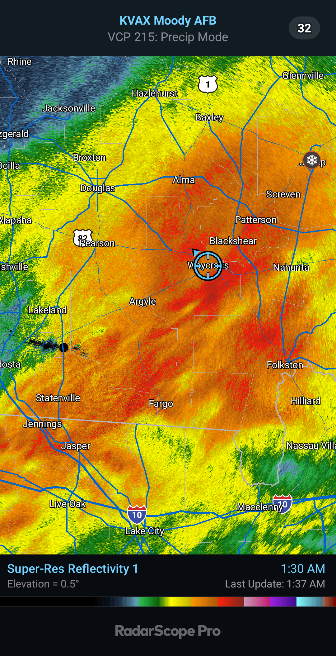
Verification for corridor from SAV to Waycross of 12Z Tuesday model runs:
-HRRR runs, which had by far the most snow, were way too high with snow and way too low with sleet because it had too cold 850s
-GFS was even worse with 850s as it had them near 0Z from the start, which would have meant much more snow/less sleet than occurred; instead it had quite a bit too much snow/way too little sleet. But also it despite its cold 850s had that mysterious 0.3-0.4” of ZR, which was significantly too high.
-Euro did well with low ZR but it had too much snow and not nearly enough IP. It appears to have had too little qpf.
-CMC did very well with its 3.5-4” of SN/IP and 1.5-2” of IP, alone, as well as only 0.05” of ZR
-NAM did similarly well with 1-2” of IP and <0.7” of SN, but was way too high with its damaging 0.55-0.8” of ZR
-ICON did well with its limited snow but it’s hard to grade the ZR and IP since it doesn’t explicitly show either (on WxBell at least)
-So overall, these HRRR/GFS runs did worst and CMC best for the SAV to Waycross corridor
Agreed CMC did a great job. Initially when we started out as snow and it had already started accumulating hours ahead of when we were supposed to transition over I thought "holy crap HRRR might be right" then we switched over to sleet the moment temps went below freezing. Very fun event though. I still have about 1.5 inches in the yard. The roads are drivable today somewhat but yesterday didn't leave the house at all. Some locations on north side of town I've seen measurements of 4-5 inches of snow/sleet.
-
1
-
-
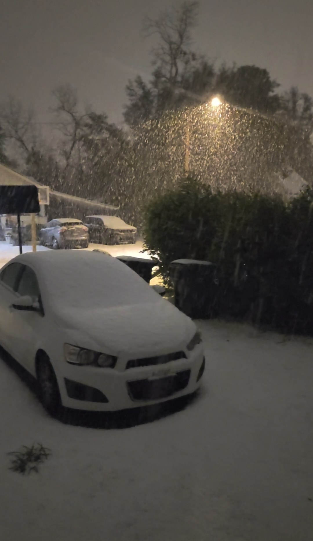
Currently 28F with sleet.
After that brief period of heavy snow, we switched back over to sleet. We were pretty much sleet for 90% of the storm. 3 inches of sleet and snow in backyard at the moment.
CMC/RGEM were the only models that showed a pure sleetfest here. Still an incredible storm though. I am curious to see what KAYS reports for totals and if we beat the 1973 record.
-
2
-
-

Coming down pretty good outside.
-
11
-
 1
1
-
-
45 minutes ago, GaWx said:
Finally at 12:50AM, I’m after all of these hours seeing some snow mixung in with the still predominant sleet! It’s 28.6F. I have ~1.25” of sleet on the ground! @dsaur would love it!
It's 28F here and heavy snow now. Finally switched over. I love how many people are outside right now at 1am.
-
1
-
1
-
-
12 minutes ago, Ketch said:
Same north of Carolina Beach. All sleet this past hour. I was kinda bummed when I noticed my footprints were still very visible from when I was out there over an hour ago. It's definitely going to eat into our snow totals down here. We're at barely 3 inches.
We've been sleet down here in SE GA for past 4 hours lol. Got an inch on the ground so far but definitely ate into our snow potential here.
Looking at Correlation Coefficient on radar, looks like we'll remain sleet for the next couple of hours.
-
31 now with sleet and freezing rain.
Light dusting of snow & sleet on roofs, cars, and grass in the area.
-
1
-
-
4 minutes ago, GaWx said:
Also, it doesn’t seem like a big ZR setup in our area with no wedge. That along with your and other reports is very encouraging.
The wind is blowing the sleet up against the window. It is accumulating on the leaves of a bush I just looked at. Down to 32.5.Yep its nearly all snow now. 80% snow, 20% sleet. Temp down to 34F. It was 43F an hour and a half ago.
-
2
-
-
36F with snow and sleet. Just started snowing about 5 mins ago. The HRRR model might be right.
-
2
-
-
1 hour ago, GaWx said:
VERY light rain here in SAV just started at 3:30PM with 37.4F.
43F and sleet rn lol.
-
1
-
1
-
-
2 hours ago, GaWx said:
Thanks for your insight! Based on the 12Z models, I agree 100%. And regardless, all of the models have increased qpf substantially! For our corridor, Euro is on the low side with 0.65-0.8”. 17Z HRRR is 0.85-1”. ICON and CMC are 0.9-1”. The others are 1-1.25”!
The variance in 850s from model to model strongly is affecting predominant precip types (Kuchera snow except Icon):-The ICON and NAM, which have <0.7” of SN, have 850s mainly +1 to +2C favoring IP/ZR. NAM has 1-2” of IP and 0.55-0.80” of ZR as it has ~1.1-1.2” total qpf. ICON doesn’t show IP or ZR, but it would have to be quite high considering the 0.9-1” qpf!
-CMC is in between with 0 to +1C 850s till going <0C late. It has ~3.5-4” of SN/IP with ~1.5-2” of IP. It has only ~0.05” of ZR.
-Euro: ~+1C 850z til late when it goes <0C. But it somehow still gives 2.5-4” of snow and 3-5” of SN/IP, combined. ZR light (<0.1”).
-GFS is significantly colder with 850s starting ~0C and later falling from there. With qpf up to 1-1.25”, it gives 4-6.5” snow/IP (mainly SN)! ZR is surprisingly high considering the 850s with 0.3-0.4”! That looks highly suspect.
-17Z HRRR is on the high end of snow/IP (almost all snow) with 7.5-8.5”!! ZR is minimal. Qpf is high at 1.05-1.35”. 850s: start +1 to 0C but fall pretty quickly.
So, lots of variance on wintry precip forms for our corridor depending on 850s with this likely historic storm!
18Z NAM is now starting to show those colder 850s. Cuts freezing rain totals in half and significantly higher snow totals across the region.
Our winter storm warning is now saying up to 3 inches of snow and 0.10 of ice. Slowly trending into being potentially biggest snowstorm on record here lol.
It's 44F outside rn, but I'm not concerned about that. DP is in mid 20s and we should be below at or below freezing about a couple of hours after the onset of precipitation.
-
1
-
1
-
-
2 minutes ago, QC_Halo said:
Assuming you’re not down under.
I'm back in Georgia briefly visiting the family before I go back to Australia this weekend. I just happen to be here during this snow event lol.
-
2
-
-
7 minutes ago, GaWx said:
Montgomery, AL, had light snow just start. It is increasing in Hattiesburg, MS, and continues heavy in McComb and N.O. At Mobile it started 3 hours ago. Pensacola NAS just stated getting flurries at 11AM EST with 28 and DP of 20. An hour earlier it was 32/8.
These high-resolution models are very interesting on our snowfall amounts now. Even the GFS ensemble mean doubled snowfall compared to previous run and is a lot wetter. If the freezing rain does happen to be limited as these models are starting to suggest, we might be in for a lot more than 2 inches of snow/sleet if temps cooperate as well.
-
2
-
-
11 minutes ago, Tony Sisk said:
In Australia? We really are snake bit in Upstate SC!
Nah haha. I'm back home visiting in S GA for a little bit. I return to Australia this weekend.
-
3
-
-
20 minutes ago, GaWx said:
HOUSTON BUSH LGT SNOW 28 23 81 N17 30.55S VSB 1 WCI 16 6HR MIN TEMP: 28; 6HR MAX TEMP: 31; 6HR PCP: 0.10;
HOUSTON HOBBY LGT SNOW 28 25 88 N16G25 30.52S FOG WCI 16 6HR MIN TEMP: 28; 6HR MAX TEMP: 32; 6HR PCP: 0.01;
*HOUSTON SW AP LGT SNOW 29 26 90 NE9G22 30.56R WCI 20 6HR MIN TEMP: 29; 6HR MAX TEMP: 32; 6HR PCP: 0.09
So, 6 hour precip 1AM-7AM EST Houston area measured max of 0.10”. That’s lighter than these 6Z runs have fwiw:
6Z GFS: ~0.20”

6Z Euro: ~0.20”
6Z NAM 3 km ~0.20”
Is the lighter than modeled amount having fallen in Houston area 1-7AM EST significant? Anyone have an opinion?
How did the HRRR do? That 12Z run is trying to give us nearly 10 inches of snow. Most likely overdone but it also has no freezing rain. Just straight to sleet and then all moderate to heavy snow. Euro also has barely any freezing rain. It just has half the QPF that the high-res models are showing.
Our winter storm warning amount has increased from 1 inch of snow to 2 inches with 0.10 of ice on top of that.
-
Had some surprise sleet earlier on south side of town. Interestingly enough on the north side of town people were seeing snow.
-
1
-


Mid to long range discussion- 2025
in Southeastern States
Posted
Sometimes we have no control over that lol.
Checking in from cold Anchorage and missing the warm SE weather.