
OKwx_2001
-
Posts
69 -
Joined
-
Last visited
Content Type
Profiles
Blogs
Forums
American Weather
Media Demo
Store
Gallery
Posts posted by OKwx_2001
-
-
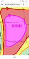
10 hatched tornado risk added now
-
Cell by Webbers Falls looks like it's about to produce. Has really tightened up the last few frames
-
Yeah 15 hatched definitely busted. 30 hatched hail and 45 hatched wind verified. So I'd say the moderate verified but definitely not for tornadoes. And I'm perfectly fine with that. Still could be some QLCS spin ups throughout the night
-
Tennis ball hail in the severe warned cell now. Will likely go tor warned pretty soon
-
That cell near Eldorado looks like it might be one to watch
-
It will forever baffle me why people complain about short lived storms getting named
-
 1
1
-
-
Eye drop supports 1000mb. That's a 9mb drop since the last eye drop 2 hours ago. Yeah let's hope that doesn't continue
-
13 minutes ago, Cholorob said:
Just a casual observer here - but constantly, and in group fashion, ripping on a guy whose opinion you disagree with isn’t a great look. Perhaps you don’t like the style in which he delivers his message, there is after all a lot to be said about form over substance, nonetheless the blowback is a little extreme for a discussion among people who are passionate about the same thing. 2 cents.
It's one thing if someone says they think a season may be inactive and then provide reasoning for it, which I don't have a problem with at all and it's great to discuss different indicators for how active a season may or may not be.
But continually trolling the forum with blatantly false statements is totally different and needs to be called out IMO
-
7
-
 2
2
-
-
1 hour ago, ldub23 said:
Yet the impression is the season is slow. Both the GOM and east coast low are still trending weaker, hardly worthy of peak season when things were supposed to be so favorable. The Azores thing no one cares about. The 2 out in the east atlantic will either dissipate or bebop north.
You are the worst poster I've ever seen on a forum
-
12
-
 2
2
-
-
4 hours ago, ldub23 said:
This idiot seems to agree with me. I said a month ago Sept would be suppressed. We are all often wrong including those who said the pattern in the peak season was "ominous" for the east coast. Turned out just the opposite.
That guy also said September 2017 would be dead and... It wasn't
-
58 minutes ago, ldub23 said:
Cool. Except for a recurver to nowhere sept is quite dead on the models. Unless a strong high builds into the NW ATL and stays locked the season is pretty much over
If the models were right all the time the 2020 season would have been dead and most of this season would be as well yet the complete opposite happened.
Maybe you should stop filling up this thread with posts that obviously won't happen
-
This one's gonna be around for awhile and will likely be the next major. Should be fun to watch as long as it recurves
-
Well August produced 6 named storms and nearly a 7th that will form in the next day or so. Also produced 2 majors in the gulf. This season is on pace to be another doozy...
Btw didn't someone on here keep posting how August would only have 1 or 2 weak storms? Yeah their posts aged like milk
-
2
-
-
BULLETIN
Hurricane Ida Intermediate Advisory Number 9A
NWS National Hurricane Center Miami FL       AL092021
100 PM CDT Sat Aug 28 2021

...IDA INTENSIFYING OVER THE GULF OF MEXICO...
...PREPARATIONS TO PROTECT LIFE AND PROPERTY SHOULD BE RUSHED TO
COMPLETION TODAY IN THE WARNING AREA ALONG THE NORTHERN GULF
COAST...


SUMMARY OF 100 PM CDT...1800 UTC...INFORMATION
----------------------------------------------
LOCATION...25.5N 86.6W
ABOUT 290 MI...470 KM SSE OF THE MOUTH OF THE MISSISSIPPI RIVER
ABOUT 380 MI...610 KM SE OF HOUMA LOUISIANA
MAXIMUM SUSTAINED WINDS...100 MPH...155 KM/H
PRESENT MOVEMENT...NW OR 315 DEGREES AT 16 MPH...26 KM/H
MINIMUM CENTRAL PRESSURE...976 MB...28.82 INCHES
-
1
-
-
Just went back and looked and it appears recon was ascending when the 990mb extrap occured so it's probably not quite that low yet. Still though, a hurricane into Cuba appears likely at this point
-
990.6 mb on recon. Oh man here we go...
-
 1
1
-
-
Pretty ominous wording from the NHC disco
"It is also
worth noting that even though the global models are not particularly
accurate in predicting tropical cyclone winds, the GFS and ECMWF
show the minimum pressure falling more than 35 mb from the current
conditions.  Based on all of this information, there is
higher-than-normal confidence that a significant hurricane will be
approaching the Gulf coast late in the weekend."
-
1
-
-
I've seen them go with a 95kt peak on the first advisory before, but it's rare. I've never seen them go higher than that in the Atlantic. The ceiling is very high with this one.
-
This right here might be the real deal... Someone's probably about to take a big hit unfortunately
-
IMO this has opened up into a wave. We'll see if anything can make it into the gulf. If so, that might end up being a big problem.
-
I'm wondering if 96L could influence Grace's track at all. The GFS doesn't develop 96L, and Grace goes right over the islands. HMON and HWRF develop 96L, and Grace gets pulled further north. Maybe a stronger 96L could pull Grace a bit more north? That's just one run from each of those models so it could all change by next run of course but 96L may be making an already very tough forecast even tougher...
-
1
-
-
My guess is that we'll see a remnant low entering the gulf similar to Fred, although I think the ceiling for this one could be higher than it is for Fred. I'm also not completely ruling out Grace going just south of Hispaniola but we'll see...
Either way this likely isn't going to end well for Haiti due to that earthquake
-
GFS turns this into a massive major that hits NC. Peaks at 940 mb before it gets there

-
1
-
-
7 minutes ago, ldub23 said:
But Supposedly we are in the most favorable phase of the MJO and still basically nothing. Dead Fred and a very struggling 95L.
Again, early August isn't usually very favorable in the Atlantic. Fred struggled because of land interaction. 95L hasn't reached favorable conditions yet but it looks like it's on its way to become Grace.
Severe Weather event October 23rd-27th 2021
in Central/Western States
Posted
Just had a tornado warning here for the second time this month