

donyewest
-
Posts
137 -
Joined
-
Last visited
Content Type
Profiles
Blogs
Forums
American Weather
Media Demo
Store
Gallery
Posts posted by donyewest
-
-
1 hour ago, Burghblizz said:
Butler certainly have a shot to pop a 15” total.
Can't wait to shovel this heavy, wet snow. Good ol' heartattack snow. Fully expecting to lose power.
-
1 hour ago, TimB84 said:
For perspective, NWS gives us a 13% chance of 18”+ at PIT. I think I saw the Steelers have a 14% chance of winning.
Kelce and Tyreek were both limping off the field last week, if the defense can push the screws a little, we should do a lot better.
-
Load up that scanner app and get your favorites ready, cut some firewood, and pull out your snow boots because I think it's going to be a good run tomorrow.
-
23 minutes ago, Ahoff said:
is it even realistic to see that much mixed precip and ice? Seems like an uncommonly high amount over a large area.
I believe that purple is high rates of snow, not the sleet color.
-
 1
1
-
-
NAM 3km still keeps it right where it's been aiming really just moving it a bit NW. Keeps Butler, New Castle, Moraine State Park in there!
-
And you all have GOT to stop looking at 06/18z runs, they aren't running with full, fresh data sets. Trust 00z and 12z runs.
-
NOAA just added a lot of "Major Impact" to the Winter Storm Severity Index. Wonder what that means, I'm ready to scrape the roof if I have to, I feel like there's going to be a lot of wet, heavy snow.
-
Finally a good Butler bullseye. I realize lot of you all around Pitt proper but feel free to drive up and get a true winter wonderland
")
-
1
-
-
Ha, told my wife that if this storm started to solidify into anything more than a few inches that I'd fix the snow thrower this weekend. ...oops.
-
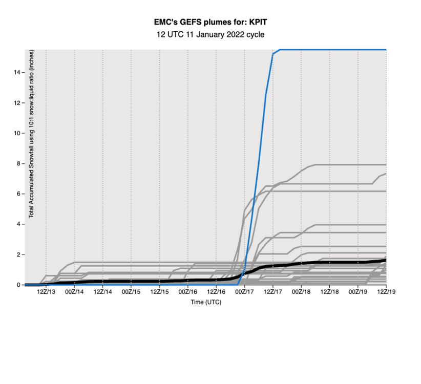
Holy cow, the operational GFS (blue line) is a huge outlier from the other GEFS ensemble members. Operational Euro and ensemble also places the low further east at hour 144.
-
1
-
-
Don't even care about snow anymore, giving up on it, I simply want it to be cold for a while and not rain. I have had moths and gnats around my porch lights multiple evenings in December. Got some bushes out front that started budding too. I'm darn near ready to put down grass seed and say screw it because La Nina during climate change means much more warmth than the "traditional" La Nina. And, really, winter is much more enjoyable when there is early snow, this late winter cold means delayed planting, sloppy snowstorms, and 30F->75~80F temp jumps instead of a pleasantly gradual spring. An El Nino wouldn't be much different, those typically mean more warmth than a La Nina, so it's hard to win like we did last year.
Shower thought from this morning had me wondering if we had more hurricanes to knock down on the heat fueling the SE ridge, water and land, then maybe it wouldn't dominate the eastern half of the US during winter.
-
 1
1
-
-
On 12/4/2021 at 2:36 PM, donyewest said:
Gonna be warm (for winter) and rainy or seasonably cold and dry for the next few weeks.
Just throwing this back out here 'til we actually get snow. Didn't NWS say that we're on track for top 10 lowest December totals? Yay.

-
The problem is that the MJO long-term forecasts typically verify poorly, it's difficult to trust anyone making a call >1.5-2 weeks out. 25% error (being generous here) from a key model component cascades into complete garbage output. Multi-member ensembles do better, trying to monte carlo out a solution, but even those are subject to long-term weirdness. Honestly, the MJO is dang frustrating. I think it was 2019-2020 winter where the convection didn't budge to a favorable phase until winter was over. Just hung out to irritate us.
-
1
-
-
On 12/7/2021 at 1:17 PM, TimB84 said:
Saw yesterday that the 90% probability of above normal temperatures area (which includes all of Western PA) on the CPC Day 8-14 outlook is the largest such area since 12/15/2015. We get this pattern in El Niño years, we get this pattern in La Niña years, so it’s almost like something else is driving it. But I’m not sure what it could be.
This is actually a good explainer on what's going on, I read the referenced research paper and it was pretty interesting (cited on 4th picture):
-
1
-
 1
1
-
-
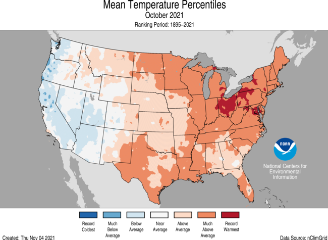
This weekend is going to be massively gross, no doubt we hit 60+ degrees (more I learn, more I respect the Penn State meteo program):
As far as the remainder of the month, Dr. Cohen performs fantastic analysis on his blog (esp. during winter) and he's from the NE so we're on the fringe of his personal bias highlights:
Edit because it would help if I added the link to his blog: https://www.aer.com/science-research/climate-weather/arctic-oscillation/
-
As a GT alum, Roll Tide.
-
Every model, including hourly refreshes and official KPIT forecast, undershot temperature performance today. I'm highly inclined to believe the 20+ above average temps for frontal passages shown under both GFS and Euro for 12/6 12z and 12/11-12/12 weekend. Gonna be warm (for winter) and rainy or seasonably cold and dry for the next few weeks. Kinda shaping up like our wild October with way above average temps and strong gradient b/t warm sector and cold fronts. Makes me wonder if we'll see some strong storms out of it.
Perfectly good waste of a wintertime -QBO.
-
Record warmest for some of us, at least much above average for all of us.
-
On 10/22/2021 at 10:54 PM, MikeB_01 said:
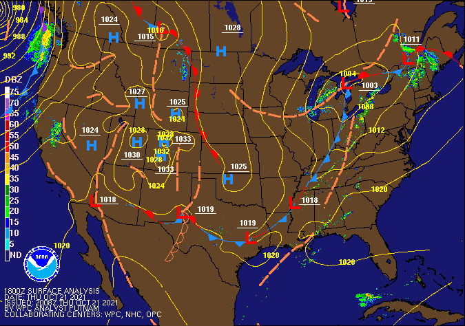
Interesting that they would mention weakening after sunset. I mean that is how it usually goes, but instability was never really a factor yesterday anyway. It was all about the wind shear. I’m sure the sunset could have caused slight weakening, but the main fuel for those storms was the shear
Reading the NWSChat report (https://nwschat.weather.gov/p.php?pid=202110232359-KPBZ-NOUS41-PNSPBZ) really sounds like no one would have thought a tornado outbreak would be probable here. If the SPC dismissed any probability of a tornado outbreak in our area in October then those heuristics (bias, really) definitely influenced the decision to not issue a watch. Hopefully they will incorporate this in future decisions because the aforementioned discussion also states that our area has seen more and more tornado warnings since 2017.
-
I read the SPC discussion around 6:30 while the warnings were still in Ohio and the SPC meso discussion said sundown would mean weakening. Lots of shear because of how the cold front was filling in after the earlier warm sector, occluding just up in Canada. Really surprised they didn't even issue a watch after there were warnings all across the line in Ohio.
-
Too close for comfort, wife got the sleeping baby and I wrangled the scared dog downstairs with one leg. Tornado looks like it hit less than 2 miles south of us, couldn't tell if it was going to get any closer without making the call. I think the incline on our southern side sheltered us pretty good because there aren't even any branches down. Power didn't even flicker and it does that when the sun is shining! Enough excitement for me today, thanks.
-
KPIT sent up another weather balloon, guess we're in a precarious spot today:
Can't see the results yet on SPC but can see what it's sent back so far at: http://weather.uwyo.edu/upperair/sounding.html
Heck, the dewpoint is 70 up here in Butler. Could still see haze/fog until the sun came out around 11.
Edit: Nice, the pdf export seems to work for the sounding: http://weather.uwyo.edu/cgi-bin/sounding?region=naconf&TYPE=PDF%3ASKEWT&YEAR=2021&MONTH=10&FROM=1512&TO=1600&STNM=72520
-
20 hours ago, Ahoff said:
I'll put my all black ones that I saw up against yours, lol.
Yep, nearly all black up here in Butler too.
-
1
-
-
I'm usually very disappointed in this weather pattern during average circumstances but extra disappointed now. Had ankle surgery 2.5 weeks ago and am sleeping in our sunniest (read, "warmest") room so I don't bother my wife. I like it cold but our Goldie Locks 10mo old won't sleep if it's not 68-72F even after putting a ceiling fan in the room.
Can't turn on the AC or I freeze the family out and I can't rely on opening the windows to cool my recovery room because it's the same dang temp outside. Really hoping we don't jump from 70s to 40s too, it'd be nice for some Fall weather.
Adding -> Last week was perfect, only times I couldn't open a window was when the neighbors were having those perfect Fall evening campfires since capping kept smoke around overnight.

Western PA/Pittsburgh Winter 2021/22 Discussion
in Upstate New York/Pennsylvania
Posted
PBZ NWS office just tweeted this, so it may not be a terrible sign, but to be expected with strong winds aloft: