

donyewest
-
Posts
137 -
Joined
-
Last visited
Content Type
Profiles
Blogs
Forums
American Weather
Media Demo
Store
Gallery
Posts posted by donyewest
-
-
3 minutes ago, TheClimateChanger said:
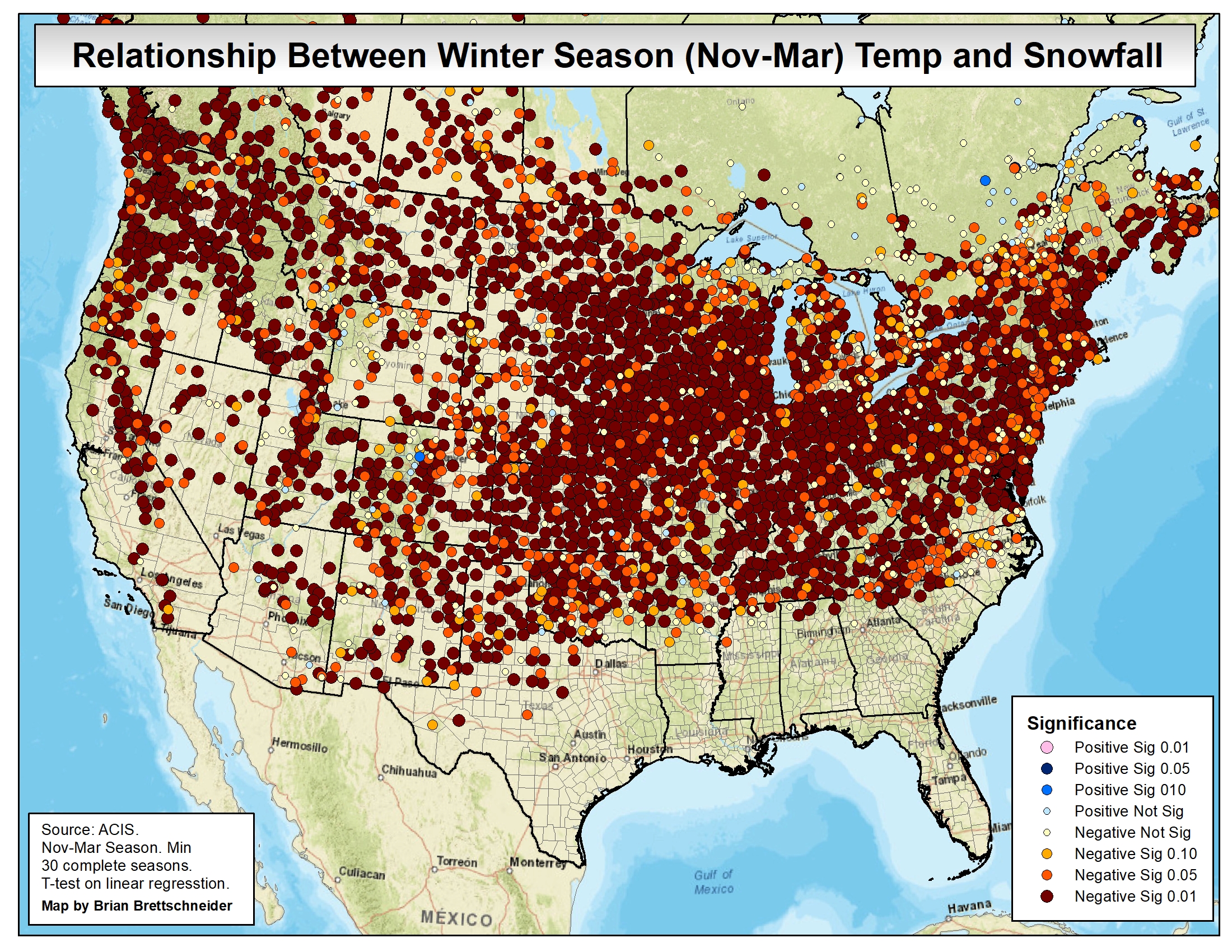
Keep in mind that data is subject to smoothing, and there can be variances. The linear regression at PIT over that interval is actually positive, with a slope of +0.05" (or a gain of about 2.5" over 50 years). But most locations around us are negative, and substantially so. Cleveland, for instance, shows a negative slope of -0.29" per year (or a loss of about 14.5" over 50 years). So it's sensitive to start and ending dates - 1973-1974 was a historically bad winter for Pittsburgh, but not as bad elsewhere.
Agreed but the 99.99% winter season temperature-snow relationship run for what would be most of of my, and probably some of yinz, lifetime is essentially = 1 (unless I'm discussing with a statistician because they are all sticklers, in which case, my apologies lol).
-
Furthermore, I have managed to get KPIT to concede that there are data quality issues w.r.t. temperature records when the NWS office took official measurements downtown before the move to Moon (airport). They have admitted that the records are biased because of all the surrounding industry - hot rolls of steel and giant coke ovens increase surrounding temps, surprise. So comparing record highs from 188x and the like to now is intellectually dishonest.
Put another way: Even with the biased high temperature readings from the past, the presumption was that there would still be snow in the winter because surrounding areas were cooler in relation, but now Moon is as cool (read: same temp) as the surrounding countryside so it requires a totally different mindset.
-
17 hours ago, Burghblizz said:
Pittsburgh will get 44” of snow a year over the long term.
And while there are broader climate considerations at play, there hasn’t been an extended period of time where those averages have significantly changed here. So I do think “payback is coming”. It’s worked that way throughout the period of recorded weather history.
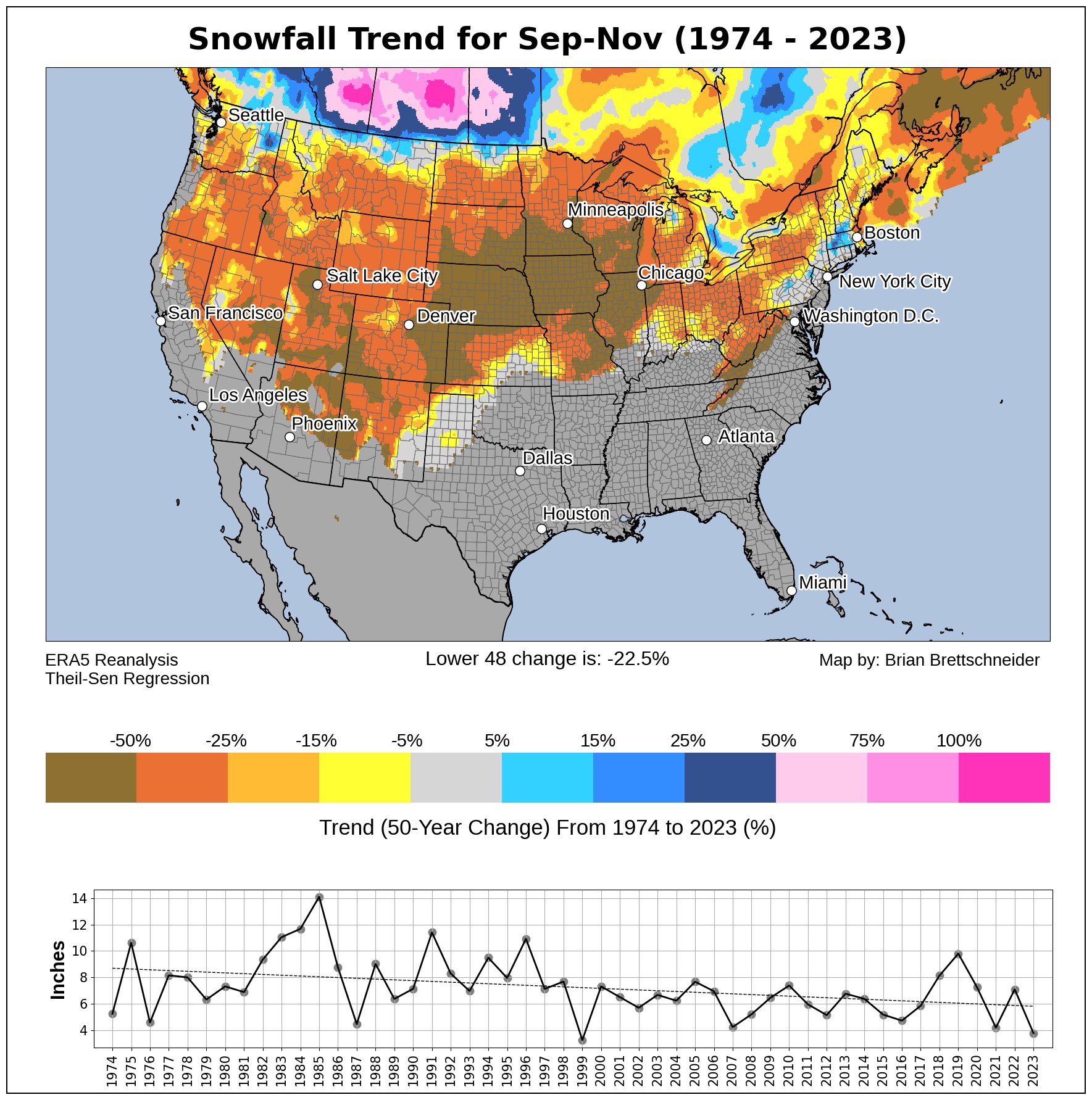
I would beg to differ, credit to Brian Brettschneider @Climatologist49:
-
Only took 2 days and we're back above average for the month for daily high temp. (We were already above for daily low.)

-
On 1/20/2024 at 11:46 AM, Ahoff said:
You have a bad year and move on.
Pfft, not this guy. I keep receipts and hold grudges LOL Seriously though...I pay attention because a deficit is a deficit does a trendline make. It's like gambling: You lose, come back to the table to lose again, and then try to play catchup but odds are not in your favor. Snow is the only respite against the gloom of winter rain and swamp-humid days that run for most of the calendar year. Especially now that I have a kid, I want them to enjoy winter as much as me, and appreciate cold weather...not be one of those people loving a +25F run in the middle of winter because they are cooold and don't own sweaters?
-
 1
1
-
-
Coming from the south, I always opt to be cautious when there's ice in the forecast, but there's a big ol' nothing in Butler.
-
6 minutes ago, TimB said:
.01” of freezing rain just doesn’t do anything for me.
0.1" does for me if we trend towards the high end. My steep Pittsburgh driveway with that kinda ice is no bueno.
-
26 minutes ago, KPITSnow said:
Also this seems like another instance where we are going from single digits to near 40 in 24 hours. Seems to happen a lot here.
Sure does. No gradual warmups (or cool downs) here.
-
When I die, I want weathermen to be my pallbearers so they can let me down one more time.
-
1
-
 2
2
-
-
Drove through the Cranberry snow burst and it was really nice to see. Sun came out up here in Butler. You'd think it were coming down heavy with how slow the drivers were taking it

-
Finally got some snow worth talking about! I've been so busy with work that I haven't had time to be upset at the lack of winter weather.
-
8 hours ago, TheClimateChanger said:
Atlantic basin due to increased wind shear
I've been watching discussions around this and there appears to be a lot of apprehension on the hurricane outlook because of how anomalously high the Atlantic SSTs presently are. I tried to find studies on the balance point between Atlantic SSTs versus Nino intensity and there aren't many, prob because aren't many samples, ha. Heck, this blurb shows an 1899 analog which did have an active hurricane season.
ECMWF pure model-based forecast just came out aggressively for an above-average season. Thing is, Nino shear is not as intense in the Gulf and mid-latitudes, and if there is a dip in Nino intensity or a block then the window may open for a hurricane to rapidly intensify. A hurricane, whether slowed/widened from shear or super cat 5, would ride up whatever high pressure region *cough*Bermuda/Azores*cough* available and that could open us up to a threat.
-
On 1/25/2023 at 9:10 PM, donyewest said:
Get out your old sheets to cover those early plants from repeated, poorly advertised frosts.
Excited for the abrupt changeover to 89F with 70%+ RH.
I was almost right!
-
30 minutes ago, Ahoff said:
For one year, sure.
Don't much care for this preview.
-
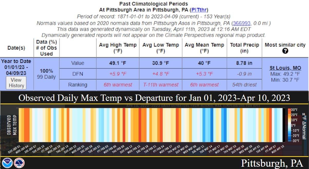
On 4/11/2023 at 8:31 AM, TimB said:
NWS posted a graphic. Just a casual 6 degrees above normal highs for the year to date, with probably six more days with well above normal highs incoming.
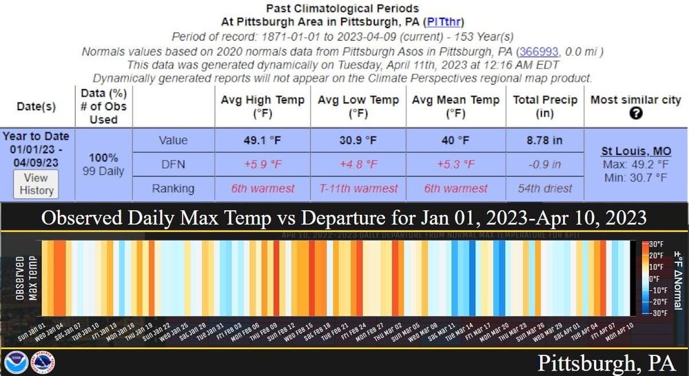
The "Most similar city" made me think about the reports that show future (yr 2050, 1.5~3.0C) climatological transitions for metro areas. Poor wording but "what city will Pittsburgh feel most like in the future" stuff. I can't find the studies or bookmarks at the moment but did find this 2019 TribLIVE article, "Study: Climate change will make Pittsburgh feel southern by 2080," that showed we will feel more like Jonesboro, Arkansas.
The visualization from University of Maryland (I goofed, this is the map linked in the article.)
So, hey, we're way ahead of the curve here by already aligning with St. Louis, MO. Only ~200 more miles south and we will prove all of them wrong, under budget and ahead of schedule.
-
 1
1
-
-
Big ol' wildfire in Armstrong county yesterday. Big dummies burning when it's dry, making more work for firefighters.
-
Round one storms have been trending north of us or puffing out, round 2 is what all the fuss is about.
-
88 would be downright bleak for early April. Those are August numbers.
-
18 hours ago, Ahoff said:
Looking forward to the 70s this week. At least they're more seasonably appropriate now, lol.
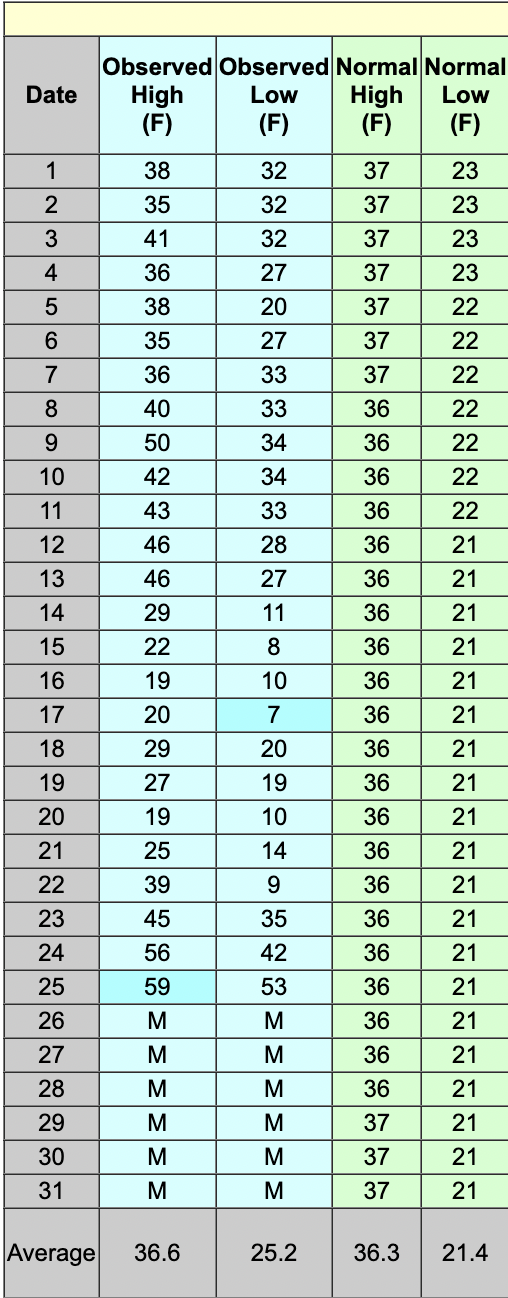
Seasonably appropriate but still early -> normal high for first week of April is upper 50s. https://www.weather.gov/media/pbz/normals/April data.pdf
-
7 hours ago, TimB said:
Most of the wind issues came with that line of storms.
Yeah, that was when power went out everywhere. Looking at the West Penn Power outages map, there are still swaths of large power outages (>250 customers.)
-
Damage reports/pictures on the KPIT Twitter are fairly significant, these winds were serious. Some *big* trees came down up just north of us (on powerlines no less). I was >< this close to pulling out the generator for the fridge and deep freezer.
-
Watching CBS news app, Ray said his power went out at his home in Cranberry Twp, and ours goes out not 3 mins later.
-
2 hours ago, TimB said:
This entire pattern wasn’t even all that wet like they were saying it would be.
Got 2.051" since the Thursday early AM storms rolled through. I'd be ok with it if it had gently rained more/less all day but 1.134" in less than an hour on Thursday afternoon, 0.528" in 15 minutes according to the two radar sweeps, shot my nerves since there are still leaves everywhere, no plants blooming trying to soak it all up yet, so water pooled everywhere. I'm knocking on wood still because, even though the soil is inches-deep muck now, none of the trees around our property came down in the (undersold, imo) wind event today.
Gettin' real tired of these Gulf Coast style 15-30min torrents that neither KPIT, the WPC, or even the SPC give much more than maybe a sentence or two like we're some afterthought up here.
-
The first warned storm around 4:30 had rainfall rates (according to MRMS) of 6.5"/hr. It was crazy here, creek across the street went up faster than the flash flood we had 1.75yrs ago.

Pittsburgh/Western PA Banter & Complaint Thread
in Upstate New York/Pennsylvania
Posted
Yeah, I don't have time for discord, so you'll never see me post there.