

ATDoel
-
Posts
79 -
Joined
-
Last visited
Content Type
Profiles
Blogs
Forums
American Weather
Media Demo
Store
Gallery
Posts posted by ATDoel
-
-
53 minutes ago, cptcatz said:
It will still have huge surge though. Surge isn't correlated with the intensity at landfall but is a function of the size, intensity, and time over water of the entire history of the storm. All the water that the storm was pushing out in front of it will still be there. Similar situation as Sandy which was a massive storm over water for a very long time and even though it made landfall with only cat 1 winds, those other factors caused 14 foot storm surges.
This is not true. With all other things being equal, once a storm starts to weaken, the surge potential starts going down. Those waves need energy (wind) to continue to push it, as soon as that energy is reduced, the amount of water being pushed by it starts to get reduced as well. What you're saying would only be true in a vacuum.
-
I'm curious why everyone thinks Ian is less organized today than yesterday. Recon found an actual defined low level center which wasn't present yesterday so the structure is significantly better than it was.
All the convection in the world doesn't mean anything if the structure isn't there to deepen.
-
3 minutes ago, StormChaser4Life said:
That LLC is moving nw away from the deep convection. Earlier it was moving west just behind convection. Seems like it is really getting well removed now.
I wouldn't be surprised if this LLC is getting ejected and we'll see a new one form to the west
-
 1
1
-
-
1 hour ago, LiQuiDBuD said:
I guess we got a little overzealous with the storm thread, huh?
Sent from my Pixel 6 Pro using Tapatalk
Several tornadoes in Alabama today, had one pass right over my house and touchdown 5 miles away.
I mean it’s this or an inch of snow in NC somewhere, beggars can’t be choosers lol
-
1
-
-
2 hours ago, nwohweather said:
I wouldn't live in North or Central AL/MS without a basement anymore. Just absurd how many times they're under the gun annually anymore, I didn't even deal with this in the Midwest
I'm in central Al. and we were hit by a long track EF3 in the last March outbreak with EF2 damage at our house. We were lucky with minor damage, two houses down lost everything. I'll tell you this, just having a basement isn't enough. They had a CMU daylight basement and the tornado ripped it in half, only EF2 damage... We're building a new house now and we're putting in a tornado room. Reinforced concrete walls and ceiling, that's the only way to really protect yourself from a direct hit.
-
1
-
-
Discussion from SPC on tomorrow's event and why they upgraded to enhance.
"with south-southwesterly 850 mb winds in excess of 50 to 60 kt increasing to west-southwesterly at 70 to 90 kt at mid levels -- is suggestive of supercells, and attendant risk for damaging winds and several -- and possibly locally strong/damaging -- tornadoes."
-
Are threads allowed here this time of year that aren't winter storms impacting the Carolinas? Ok, cool.
Models have been picking up on this system for several days now with unusually high agreement, showing severe weather over three days impacting Texas to the Carolinas. I guess that's why the SPC has issued a 15% risk a whole week out, don't see that very often.

-
2
-
-
holy model divergence. I assume the HRR is far more likely here, why is the NAM showing such a high level event?


-
I know most of Central Alabama is out of the enhanced area, but something about this graphic makes me feel like we're about to get screwed again.... but seriously, I still have tornado debris in my front yard waiting to be picked up, I wouldn't mind if the other states took this one for us this one time.

-
14 hours ago, brianc33710 said:
I thought for sure the Brent to Wilsonville would at least get a low-end EF-4. But we did wind up with a really wide twister.
Do they even classify tornadoes as EF4+ if there is no structural damage of that magnitude? Very likely it was that strong in the wooded, unpopulated areas.
-
46 minutes ago, DanLarsen34 said:
Sounds like the Brent-Centerville tornado will end up at EF-3 for a rating. We got so incredibly lucky that this tornado tracked where it did. I have no doubt that if this thing had occurred just a few miles further north, we would have seen EF-4 to EF-5 damage.
As bad as last week was, it could have been even worse.
It made up for windspeed by being huge, 1.3 miles wide according to BMX. Crazy.
-
1 hour ago, StormChaser4Life said:
Is there a rating yet on the Greensboro tornado that went through Brent and Centreville?
EF2 but still preliminary, they haven't surveyed the entire track yet. I would guess today or tomorrow.
-
 1
1
-
-
Bmx were sleeping on that Clanton cell, not done in Bama yet :/
-
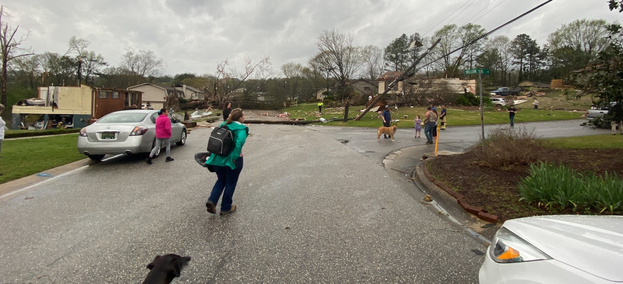
My neighborhood got hit hard, only minor damage to my house, one house down from me lost their roof, two houses down from their lost their entire first floor. Pelham

-
2
-
 14
14
-
-
I took my family and drove north, TDS went right over our house in Pelham
-
1
-
6
-
-
Just now, SnowenOutThere said:
I think the main question is whether the storm is able to redevelop another tornado before it hits the suburbs because the old tornado looks done, just hope it doesn't redevelop.
storm has strong broad rotation, could drop another tornado in a matter of minutes, definitely have to watch it.
-
all those shallow storms south of the tornado, could that be choking off inflow?
-
 1
1
-
-
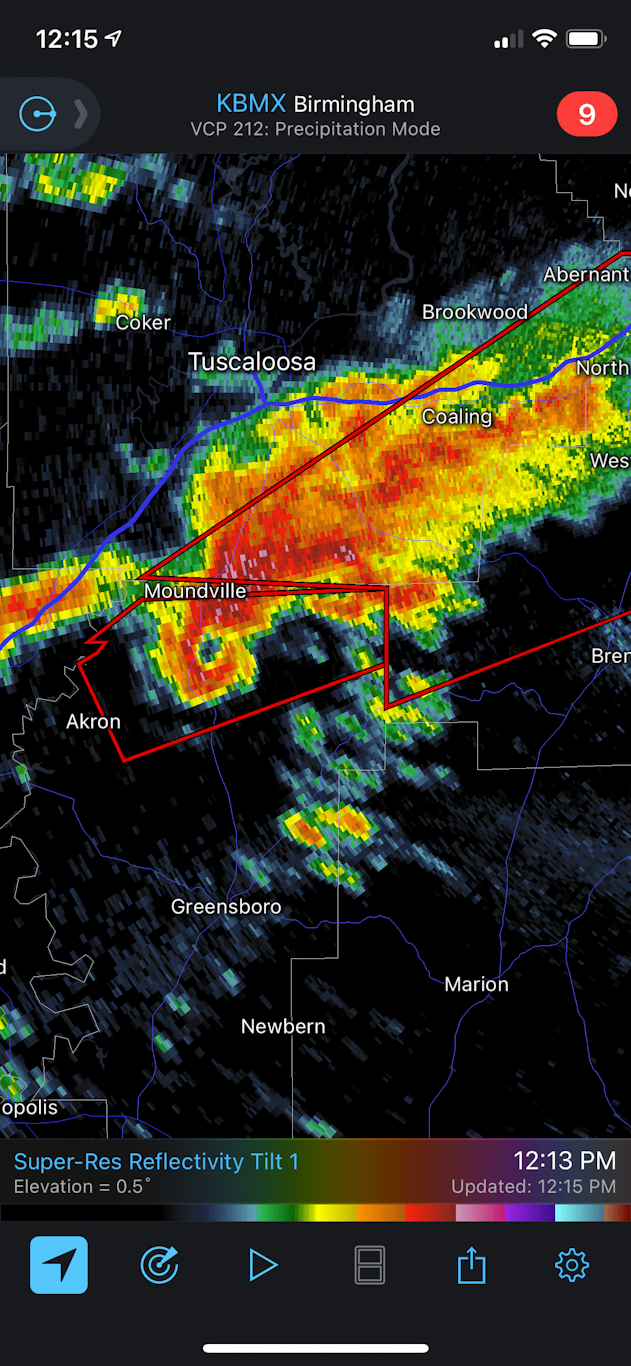
1 minute ago, janetjanet998 said:
ACUS11 KWNS 251728
SWOMCD
SPC MCD 251728
ALZ000-251930-
MESOSCALE DISCUSSION 0255
NWS STORM PREDICTION CENTER NORMAN OK
1228 PM CDT THU MAR 25 2021
AREAS AFFECTED...PARTS OF CENTRAL ALABAMA
CONCERNING...TORNADO WATCH 50...
VALID 251728Z - 251930Z
THE SEVERE WEATHER THREAT FOR TORNADO WATCH 50 CONTINUES.
SUMMARY...A TORNADIC SUPERCELL OVER NORTHERN HALE COUNTY MAY PERSIST
WITH TORNADO THREAT EXPANDING EAST/NORTHEAST FOR SEVERAL HOURS.
DISCUSSION...A LONG-LIVED SUPERCELL, NOW TORNADIC AND LIKELY
PRODUCING A STRONG TORNADO, CONTINUES TO MOVE EAST/NORTHEAST ACROSS
NORTHERN HALE COUNTY, AND HAS SHOWN NO SIGNS OF WEAKENING.
THE AIR MASS AHEAD OF THIS CELL IS UNSTABLE AND WARMING AS THE WARM
FRONT CONTINUES TO LIFT WELL NORTHEAST OF THE BIRMINGHAM AREA.
LATEST VWP OUT OF BMX SHOWS 0-1 SRH OF 329 M2/S2 GIVEN A MOTION OF
245/38 KT, WHICH SUPPORTS A STRONG TORNADO.
GIVEN WARM/MOIST ADVECTION EAST OF THE CELL, THE TORNADO THREAT MAY
PERSIST FOR A COUPLE HOURS AS IT MOVES EAST/NORTHEAST ACROSS SEVERAL
COUNTIES IN ALABAMA.
..JEWELL.. 03/25/2021That's horrible, that takes it right over the southern Bham metros, the most densely populated part of the state
-
Just now, SnowenOutThere said:
If the storm holds it would hit the Hoover almost directly
shhhhh I'm over here on the Pelham/Hoover line nervously taping my foot
-
2 minutes ago, TimB84 said:
* Locations impacted include...
  Brent, Centreville, Moundville, Lake View, Brookwood, Coaling,
  Vance, Woodstock, West Blocton, Tannehill Ironworks State Park, Low
  Gap, Mertz, Mercedes Benz Of Alabama, Eoline, North Bibb, Maxwell,
  Hull, Hagler, Green Pond and Pearson
A car dealer makes the list of “locations impacted.” Don’t think I’ve seen that before.
nah, that's the Mecedes Benz automotive plant. It's a huge complex, they even have a dedicated exit from the interstate
-
.............

-
3
-
2
-
-
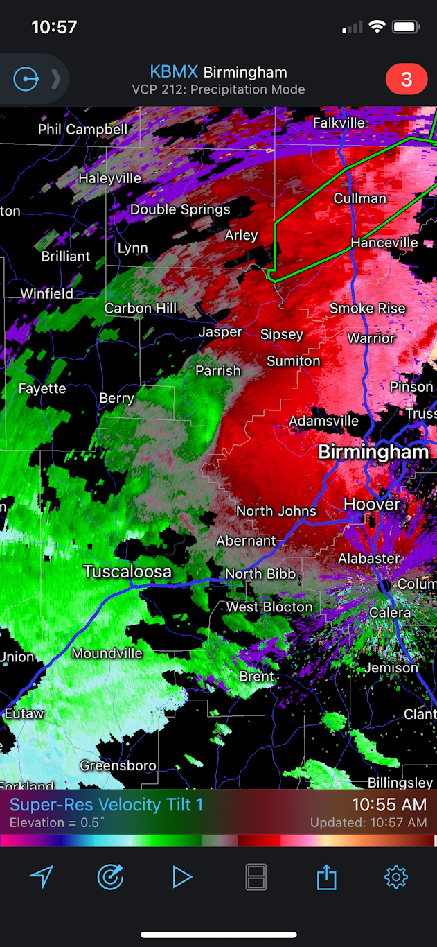
whelp.....I'm directly in the bullseye of the only tornado warned storm right now, 50 miles away. Let's hope it isn't as long tracked as we think..... I may just get in my car and hit the interstate if this thing doesn't lift before getting here.
-
5 minutes ago, yoda said:
HIGH risk expanded more eastward and SEward in 1630z update... HIGH now includes BMX metro
ETA: TOR probs remain 30%, but were increased in size with respect to HIGH risk being increased in size
Where are you getting that? and here I was happy to simply not be in the HIGH Risk this go around...
-
Seeing strong broad rotation on those cells west of Birmingham

Hurricane Ian
in Tropical Headquarters
Posted
This last dropsonde doesn't make any sense to me. ADT readings and T numbers show significant strengthening of Ian since it made landfall in Cuba, the storm looks tighter and more organized on satellite as well, how in the world did it weaken so much? ADT is estimate 937 mb, that's a 30 mb difference from the drop.