
CANNOTDIVIDEBY0
-
Posts
49 -
Joined
-
Last visited
Content Type
Profiles
Blogs
Forums
American Weather
Media Demo
Store
Gallery
Posts posted by CANNOTDIVIDEBY0
-
-
I have to travel to Davenport Saturday evening, so for once I am rooting for a miss north
 . Looks like i-80 should be pretty drivable at the very least.
-
Well that GFS run certainly was a move
-
Once again, need to travel for the weekend. These snow storms just love these Fridays.
-
23 minutes ago, ILSNOW said:
worst model followed by GFS and NAM!!!!
And we will have a juiced run of the HRRR as well.
HRRR Nailed the lake effect snow IMBY last February and that means its the best always
-
Ah yes, the worst case scenario for my drive to Peoria on Friday.
-
I pray the fine people at IDOT will have the highways clear by Friday... Right!?
-
1 minute ago, SolidIcewx said:
GHD III did a south shift in the final day before. But hopefully y’all get some of the wealth
The worst part is, I'm traveling south on Friday lmao
 .
.
-
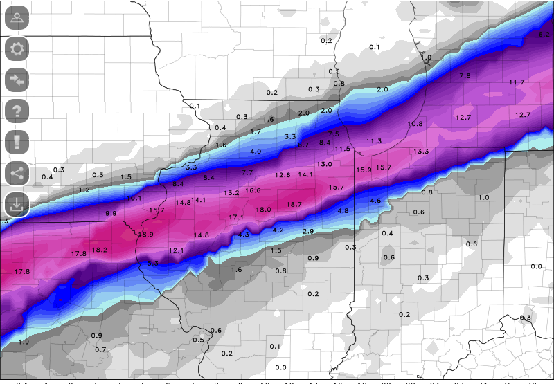
Figures the one time I don't want any snow, the GFS has it pinned on top of my house for 3 days straight
Any other storm this would of drifted south or north by now
-
I have to travel on the 18th for a bowling tournament to Peoria. So for once, I hope this goes north.
-
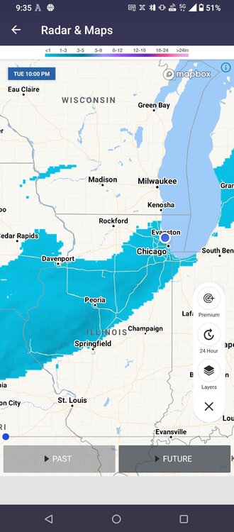
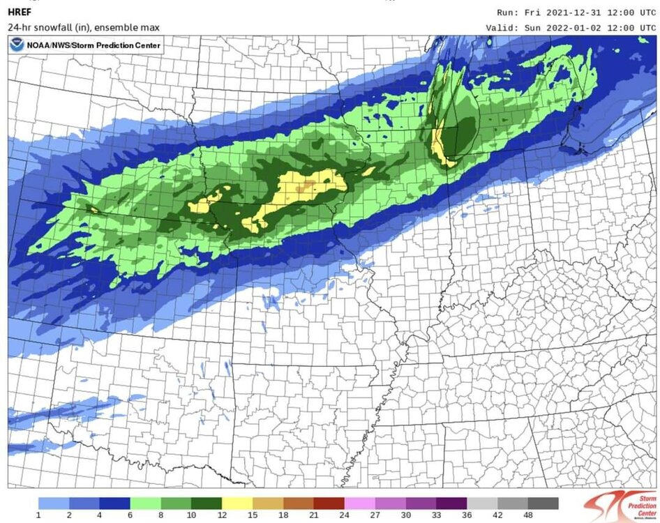
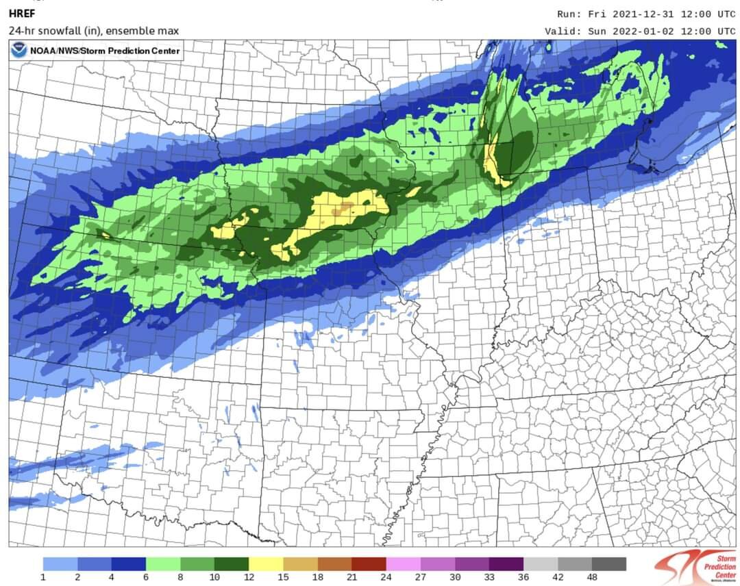
Future 48 hr snow totals from the weather channel app. Pack it up boys, it's a dud.
-
 1
1
-
 2
2
-
-
9 minutes ago, Jersey Andrew said:
Has Chicago ever had a lake effect enhanced snowstorm a la Cleveland or Buffalo? I went to school up at Northwestern and remember the 20+ inch storm in January 1999 but no real lake effect machine up in Evanston.
Usually happens once a year. Last year we had a big one where lake enahnced snow torched the shoreline and about 5-10 miles in. Then just last Friday we got 8~ inches just on lake effect snow. But no, we don't ever get what buffalo gets. The wind rarely comes off the lake from the east.
-
2 minutes ago, Kaner88 said:
Total 00z HRRR snows.
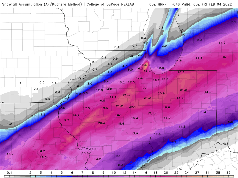
27 inches IMBY I'm ready to be buried

-
1 minute ago, Louieloy102 said:
We'll will ourselves to 10" one way or another
I'm still doing the lake effect snow dance for Thursday
-
Watching the NAM pick up on lake effect snow (stfu and let me have something)

-
 1
1
-
-
2 minutes ago, CoachLB said:
Riding the Nam will break your hearts lol.

-
5
-
-
NAM is a slight tick northwest for the first event, but that can be a lot for some people *like me*
-
1
-
-
I saw someone say something about the high pressure over Canada is running a bit weaker than what is modeled. Looks like its about 2-3mbr weaker with my completely untrained eye. Will this have any real impact on the trajectory of the main event?
*I guess I should mention that the pressure right now is a little bit weaker. I don't know what it was 6~hours ago.* -
Please sir, can you spare a bump or two north?
-
1
-
-
watching the gfs and crying as a northsider
-
1
-
-
NAM plz be right. I don't wanna go to work.
-
1
-
-
**** the NAM, all my homies hate the NAM
-
28 minutes ago, michsnowfreak said:
Feb 15/16, 2021 honorable mention
ORD: 6.9"
DTW: 10.4"
TOL: 14.5"
But here's calling Feb 1/2, 2015
ORD: 18.0"
DTW: 16.7"
TOL: 12.0"
6.9" at O'Hare but the shoreline got 12-18 inches
-
2
-
-
Had about 3-5 inches in West Ridge when I left for work this morning. Roads were completely cleared. Good work by the plow trucks. I had to travel 50 miles south (Lake shore drive to 90 to 57 to 80) for work today, where they got maybe 2 inches of snow and the roads are an unplowed mess.
-
2
-
-
From Tom skillings Facebook post 5 minutes ago.
As a certified professional weenie, I'm taking this to the bank.

March 3-4 Potential Winter Storm
in Lakes/Ohio Valley
Posted
Is it me, or have the models been absolute trash this year?