

Snowfan96
-
Posts
66 -
Joined
-
Last visited
Content Type
Profiles
Blogs
Forums
American Weather
Media Demo
Store
Gallery
Posts posted by Snowfan96
-
-
35 minutes ago, osfan24 said:
18z NAM actually gave me some real interest and hope but I'm not surprised by the 0z at all. Where is the cold air right now? These setups where we are waiting on the cold air to bleed in almost always end up much father north and west with the significant accumulations. You can forget models and just forecast these by climo and the history of seeing these storms a billion times here before.
9 times out of 10 this is the case. Jan. 3rd was one of those rare exceptions where areas hit the mid 60s and then got a foot of snow 12-18 hours later. But that was a different, more dynamic setup with distinct LP riding the boundary.
The downsloping in the NW flow can certainly help the warm air hold in the PBL in events like this one. It will all come down to the degree of mesoscale banding and where it sets up, although the higher elevs and mtns certainly have an advantage going into this.
-
3 minutes ago, psuhoffman said:
Not only is it placing the banding in a different location it’s oriented completely off from all other guidance. If it did happen to be right by some miracle this would be far more impressive than it’s coup Jan 3 where it was right first at 4-5 days out.
And since that Jan 3 event so many folks have wanted to call it the “new king”, but it really just got lucky a few times. The ECM still outperforms over the GFS.
-
2 minutes ago, Fozz said:
And it's a relatively recent thing too. Before the mid 2010s, they never used to do this. They would just give their forecast, tell the public how to prepare for whatever is coming, and that was it.
Normies back then had no idea what the GFS or NAM or ECMWF were, and honestly it is better that way.
This! (they might as well be saying: “I have no clue, but here’s what xyz model says will happen”)
-
6 minutes ago, mappy said:
lol I wish
I wish too! Anyone know if this model is any good?
-
Little love for northern areas - axis remains farther south when compared to the NAM3km, etc...

-
 2
2
-
-
I put more weight in the NAM nest vs. the NAM12, but accums could ended being splotchy (as depicted in the NAM12) since those areas that aren't beneath a heavier band will end up having their temps stay a bit elevated, which will only work to further reduce their accums. If the banding occurs where currently depicted in the CAMs, folks N/W and in higher elevations will do better with this one.
-
Hoping the hi-res guidance is onto something with their shift of the heavier snow north and west. The globals have not progressed to that idea, at least not to the same degree.
-
Given the pattern and the ongoing theme for the winter with high amounts s/e, the GFS soln is probably gonna be close to reality.
-
2 minutes ago, psuhoffman said:
Why not set the bar low then be pleasantly surprised instead of investing and being frustrated when everything trends to exactly what climo in a positive NAO progressive pattern says is most likely.
this has been my approach the entire season. it’s not a favorable pattern for the mid atlantic, so it’s best to keep expectations low and realistic until truly convincing data points otherwise
-
1 minute ago, WxUSAF said:
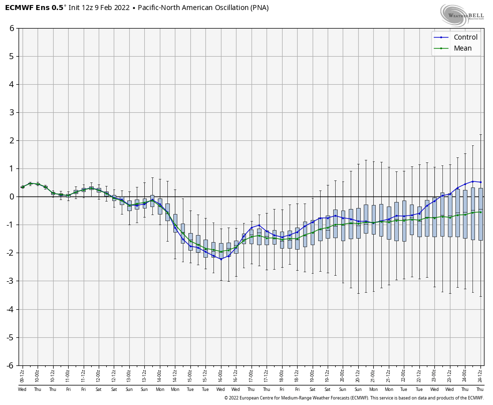
^look at the EPS 500mb anomaly chart for Sunday the 13th at 12z and tell me how that’s numerically a negative PNA.
Of course not, which is why I said AFTER this next “event” in my earlier post.
-
-
7 minutes ago, WinterWxLuvr said:
You’ve been preaching this crap all winter. Where’s our massive -PNA?
Sinners you are going to hell!!
Have no fear, the massive -PNA is about to show its ugly head.
-
IF we get anything out of this possible event, make sure you enjoy every minute of it! For many in this forum it looks like the last chance until December!
-
1
-
-
10 minutes ago, WinterWxLuvr said:
Of all the storms we’ve had this year, this is the one most likely to trend north/west. There’s nothing to the ne shunting out to sea, it’s later in the season where the cold ouch isn’t quite so forceful. I’ll bet the NE people are just sitting back smiling.
Excellent point! (Timing of the key features will of course be crucial).
-
1 minute ago, mappy said:
finale? winter is over already?
Everyone knows we only have 2 shots left this season…where ya been? LOL
-
1 minute ago, IronTy said:
It's over.
It is indeed…on to next season!
-
 2
2
-
-
Even JB isn’t too hopeful about the threat for 2/13-2/14…that alone tells you this is unlikely to materialize!
-
After reviewing the teleconnections and ensembles, it looks like a warm 2nd half of February - at least that's what the overwhelming evidence suggests. It very well could have been that the Northeast blizzard last weekend was the real turning point in the pattern.
-
1
-
-
22 minutes ago, SnowenOutThere said:
I would take this storm

Tell me about it! I’d take anything that brings at least an inch of snow. Hoping for at least one last gasp before spring fully ensues.
-
7 minutes ago, IronTy said:
It's like I said, winter is over after the next week. We can't complain, we had an awesome January this year.
I have to say January turned out way better than expected following the disastrous December. The cities and points south/east did well in January, but a lot of other folks got fringed.
-
22 minutes ago, MillvilleWx said:
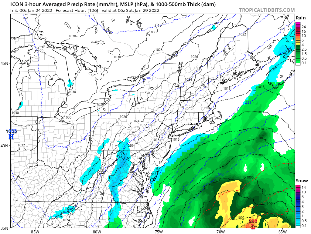
GFS continues to hold firm on the cold push. The NAM Nest was still a pretty solid ice event for areas north of a line of GAI-Savage-Annapolis. A more significant ice event is increasingly likely over areas north of I-70, especially once you get towards Central Frederick/Carroll/Baltimore/Harford counties. Temps will be borderline south of I-70 for areas below 500’. Above 500’ 27-30° will be possible with light/mod precip still in the area. CAA will still be occurring through the AM, so that benefits the icing setup with the FRAM numbers getting more substantial through the AM as a result. I think WSW criteria ice is possible for the northern tier, but a forecast around 0.1-0.2” is probably a good start. Glaze to 0.1 is probably solid starting point south of there.
Regardless, local impacts to travel will be likely. Roads will get icy through the day and remain that way thru Saturday AM. It’s not going to be an all timer at first glance, but still not half bad. DC area will likely miss a majority of the ice.
Do you think the wave of low pressure behind the front will be enough to induce precip in the cold air? I'm always doubtful in these scenarios. The NAM shuts off most QPF once the cold air arrives - and 9 times out of 10 that always seems to work out best - even when there is wave along/behind the front.
-
I recognize this upcoming “event” on Friday is a bit different set-up, but cannot help but think the GFS and ECM are once again over-doing the QPF in the cold air behind the front (like they did on Jan. 20).
We’ve all been down this road so many times - most of the QPF will be gone before the near/sub-freezing temps arrive - even N/W of the cities.
-
2
-
-
-
14 minutes ago, Kevin Reilly said:
February of 22 or 23?
Gotta be 23, Feb 22 is modeled to be a torch on CFSv2

February Medium/Long Range Discussion
in Mid Atlantic
Posted
D for me here as well…in Frederick County. Better than I expected after a very warm start in Dec., but still not a good season.