

jdpack
-
Posts
16 -
Joined
-
Last visited
Content Type
Profiles
Blogs
Forums
American Weather
Media Demo
Store
Gallery
Posts posted by jdpack
-
-
5 minutes ago, weatherpruf said:
At least where I am it didn't sleet as much as it snowed beforehand; I don't think the sleet caused us to lose all that much, iff it had stayed snow...not sure but it still doesn't look like it would have been huge totals here. Maybe 8-10 if it stayed snow? The heaviest precip here didn't last once the sleet rolled in.
My prediction yesterday was sleet due to warm air aloft. I didnt see that big of a dry slot coming in.
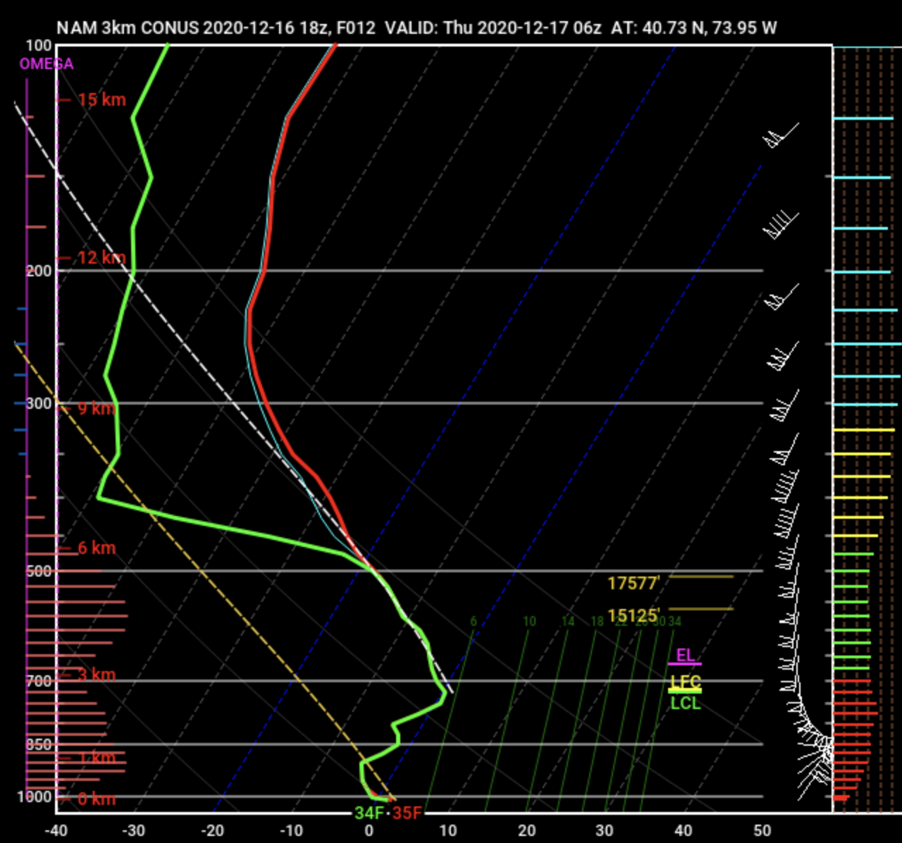
Regardless, the NWS should have been a lot more conservative with the forecast, especially in the afternoon. The warning signs were there well before the 18z NAM3k rolled out. I think it was 2-3 hours after NWS was sticking to 9-14 then below had "uncertainty remains with mixing"... There was no true uncertainty.
My cardinal rule of winter storms: If a warm nose is even in the discussion, then you should remove 30-50% of the predicted totals. Even with surface temps in the lower to mid 20s, you go up 1000-2000 feet and it was 35-40f.
-
Looks like that warm nose affected the totals as was discussed yesterday in the other thread.
-
 1
1
-
-
16 hours ago, jdpack said:
My final call:
JFK ~1-2LGA 2-4
Central Park 3-5
EWR 4-6
Not too far off on these....
JFK- 2-3
LGA- 3-6
Central- 4-7
EWR- 3-6
-
11 minutes ago, SnoSki14 said:
Yeah I wouldn't be surprised to see this. I think a lot of us are getting too weenied out, I smell a bust with a lot more sleet than people think.
This is most likely the scenario unfolding unless you head North and/or West of Fair Lawn.
If NYC / Newark gets more than 6inches from this storm Ill eat crow.
-
 1
1
-
-
20 minutes ago, shadowsintherain said:
10-12" for the south shore? I'll take it!
this includes sleet.
-
2
-
-
Best shot for NYC is now through 9-10p to accumulate 2-4 inches before sleet and rain mix in.
-
1
-
 1
1
-
 2
2
-
-
But that is 06z lol
-
1
-
1
-
-
Just now, NJwx85 said:
The 18z NAM is not horrid, stop posting bad/wrong information.
This aint gonna get it done
 - Warm nose gonna bust this wide open
 This aint it
-
1
-
1
-
-
10 minutes ago, MJO812 said:
Who knows if the Nam is right.
Every other model has it snowing hard before a possible changeover.
Those models dont take into account sleet mixing in. If (more like, when) the sleet mixes in, that 10:1 ratio goes POOF and the totals go with it.
-
1 minute ago, liwxfan said:
If you’re worried about a warm nose just step out side for a few mins.
Warm nose has nothing to do with surface temps.
-
1
-
2
-
-
9 minutes ago, nycsnow said:
1-2? Maybe in an hour
Im as big of snow weenie as anyone. But this has bust city written all over it. That warm nose will destroy dreams.
-
1
-
-
My final call:
JFK ~1-2LGA 2-4
Central Park 3-5
EWR 4-6
-
8
-
2
-
-
Surface temps are not going to be the issue. The temps aloft are... and they not working in our favor. The models have shown this, and looking to our south, they are sniffing this thing out. I say, you need to be West of EWR to enjoy all snow here.
-
In JC here. I am not liking the 850/700 temps.
Surface temps are fine, but I think there is a huge bust potential here. My experience from warm noses like this are they usually over perform and tend to creep further North and West than predicted. The 9-13in here is in serious question.-
1
-
Major Nor'easter snow storm (possible top 20) Noon Wednesday-Noon Thursday Dec 16-17, 2020
in New York City Metro
Posted
NAM3k does very very well with temp profiles. HRRR sucks at it. When I lived in NC, we got harsh reality lessons in warm noses. With the 6600ft mtns nearby, often we could get RAIN, with surface temps in the low 20s. HRRR always thought it was snowing. NAM sniffed it out and called it.