

JoeSnowBOS
-
Posts
125 -
Joined
-
Last visited
Content Type
Profiles
Blogs
Forums
American Weather
Media Demo
Store
Gallery
Posts posted by JoeSnowBOS
-
-
36 minutes ago, ROOSTA said:
I don't know why I post snow amount maps. Admittedly it's an addiction, this is my fix.
Not a blockbuster but snow is snow.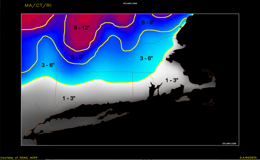
Map is way off but like the look!
-
 1
1
-
 1
1
-
-
34 minutes ago, PhineasC said:
What was this clown saying during the blizzard SNE had earlier? Many places in SNE can easily still hit average, but by then I'm sure this joker will be talking about the drought and his tomatoes.
Boston meteos have been an absolute joke this winter. You have Mike wankum who I am not even sure knows what he is talking about. Said this coming storm isn’t a big storm at all. Channel 4 weather behind the scenes guy saying no more snow for rest of year - it’s been an embarrassment. Thank goodness for Harvey Leonard.
-
1
-
-
3 minutes ago, weathafella said:
Maybe we should wait till Sunday?
I said “IF”
-
“IF” GFS is correct and other guidance that is east, the EURO should turn its badge in and walk out. This model has been a complete failure - and the main reason for all this hysteria and causing complete chaos.
-
 1
1
-
-
Eastern New England seems to be the lock it in area. Central /western areas still uncertain - tomorrow clarity comes
-
This storm is coming and it’s certainly a eastern New England special , just a matter if it’s a big hit for western area or not. It’s coming though. If it ends up OTS, that’s a complete model suite fail and we should just stop looking at models this far out. Buckle up - it’s coming eastern New England
-
2
-
-
2 minutes ago, ORH_wxman said:
Yeah today the trends were pretty decidedly against a 100% southern stream phase. Gotta update the priors.
The question is now how much of whatever less than the 100% do we incorporate into the system. I guess something else weird could change in the northern stream but it seems to be pretty steady on most guidance.
Don’t matter if it’s not 100%, even without that the QPF is impressive and translates to quite a bit of snow.
-
Anyone saying rain for coast is model hopping. It’s way early for any details. Let’s get through tomorrow before we start with any details. So early
-
 1
1
-
-
5 minutes ago, mahk_webstah said:
I don’t have a good feeling about this one. Big storms show early, generally, and when the ops waver it is no problem if the ens still look good. Clearly we need a shift in the data. The trend that we wake up to Tuesday morning will tell the tale for most while the eastern people hump, pump or jump every 6 hours.
What 06Z EPS look like? Worse then 12Z? Euro been offshore run after run unfortunately
-
7 minutes ago, Kitzbuhel Craver said:
The 971 on approach looks tasty
EURO has a big storm today that went OTS, this one looks to follow suit and be OTS. EURO is trash model
-
1
-
-
6 minutes ago, MJO812 said:
Euro would be really nice based off H5. Let's see what the eps shows soon.
Maps?
-
Euro is the best track - GFS is way way west. At least EURO has front end snows
-
Just now, Damage In Tolland said:
There will be
lol where??
-
25 minutes ago, WinterWolf said:
Lol...he’s banking on the Euro I guess. NWS latest map is 6-8 with pockets of 8-12. If that’s a snooze fest, I’m a lil baffled?
NWS snow maps are unreliable...
-
29 minutes ago, Damage In Tolland said:
He’s in the 10-14” zone
There is no 10-14 zone...
-
1
-
-
This has bust written all over it for areas they expanded the warning to (Boston/NW). I don’t even know why when most models show advisory snows at best for Boston. It’s like who is calling the shots with 6-8 and even 8-12 right in SW burbs. Insane and expect complete bustorama
-
1
-
1
-
-
2 minutes ago, ORH_wxman said:
I honestly thought that big CCB at 48h was gonna destroy E MA but then it slid just east. It got lighter stuff a little further inland. But this was kind of a wash with 12z.
Lock it in. If similar to 12z it seems to back the consensus on the forecast
-
3 minutes ago, Damage In Tolland said:
Think we’re close to regional 3-6/4-8” type event
Not region wide at this point
-
1
-
-
Just now, RUNNAWAYICEBERG said:
But JoeKnows.
Oh no Joe don’t know!
-
1
-
-
I blame Pete Bouchard. He already put a snow map out. Guy can’t help himself. 3-5 Rhode Island and southeast of 95 and 1-3 NW of that line. Says changes likely so I ask why bother right now when the models are all over the place and no one knows!
-
1
-
-
UKMET a hit
-
8 minutes ago, CT Rain said:
EPS snow probs aren't great but the op is certainly juicy.
EPS “trumps” operational. Unfortunately not a good sign but some hope still
-
4 minutes ago, MJO812 said:
Here comes the Euro

Wowza that’s a great look. Now what happens beyond that? Do the jet streams connect and come up the coast or does it not and go OTS??
-
1
-
-
Just now, Greg said:
Something really doesn't look correct with the Canadian Model. Definitely on its' own.
That flat out won’t happen

Currently monitoring guidance for March late 3rd through the 4th for the next ( beyond the 28th) significant event
in New England
Posted
Eastern SNE will lose again! This move north/west was insane from the EURO