Irish
-
Posts
75 -
Joined
-
Last visited
Content Type
Profiles
Blogs
Forums
American Weather
Media Demo
Store
Gallery
Posts posted by Irish
-
-
13 minutes ago, MJO812 said:
DT expects the models to trend west this weekend .
Who's DT? Cause I respect Daryll Talley, Demaryius Thomas, and Derrick Thomas but didn't know any were meteorologists.
-
 1
1
-
 2
2
-
-
1 minute ago, NittanyWx said:
I know how to read a clown map. I also know how to read a temperature map and a sounding. You don't want this fight.
Put your dukes up!
-
9 minutes ago, TriPol said:
If we can push off this storm for 12 hours, we could get a helluva Giants game.
We don't need snow for that. Watching the Giants play is like being in hell already.
-
 2
2
-
-
57 minutes ago, wdrag said:My take based on all primary models through 00z-06z/14: Sunday afternoon-next Thursday I84-I95 corridors (17th-21st), a large storm will produce heavy rains NJ-se NYS-LI-CT-MA by Monday morning (roughly 1-3"), then abate and temporarily be very mild Monday. Then the precip "possibly" redevelops Tuesday or Wednesday as a period of mixed ice or wet snow from NJ-PA northward to NYC-Boston. Snow accumulations will be elevation dependent (as usual)... for now, the ensemble snow accumulations (snow depth change) are small... generally under an inch in our area.Tue-Wed is fraught with uncertainty... does precip occur or not? If it does, then I have high confidence it would be wintry...just not sure if precip redevelops. Ensembles are spreading out the wintry stuff a little further south. EPS is much sharper with the trough here in NJ next Tuesday... that will be critical. If it's mushed out with wsw 5H flow instead of ssw flow, then part two is probably offshore. Just too uncertain for me to express confidence on part two.Also, am aware that part one Sunday night-Monday won't be a nor'easter but instead probably an inside runner.Basis for wintry is scrolling through "24 hours snow depth change" on CMCE, EPS, GEFS.Will check back Friday to see how this unfolds. (as some say, am a Modelologist- it isn't like it was 30-35 years ago when two model runs/day and couple models to monitor-dig into--- now it's speeding through many general model ideas, counting on model intelligence to lead me-us down the right path)
This is what I was mentioning earlier. The dude I was reading from another board, is a bright one, and he was all over the cold getting in here and producing wintery precip, while everyone else was saying all rain. Should be fun to track and see how it unfolds...
-
 1
1
-
-
I frequent another board and one guy there is suggesting that models are catching up yet but that there could me more cold air and snow than most expect with this next system.
-
 1
1
-
-
2 hours ago, zenmsav6810 said:
Everything covered im glad church was canceled!
You could always just cancel church permanently. I did, talk about living free!
-
 1
1
-
-
-
-
18 minutes ago, Rtd208 said:
Winter Storm Warning just issued here for 11-15" of snow.
Same here and honestly, I think the high end listed could end up really being a possible low end when all is said and done as we could hit 20" or more.
-
EURO WAS HUGE!
-
 2
2
-
 1
1
-
-
4 minutes ago, dssbss said:
when is Euro up?
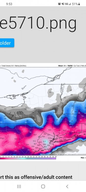
It's in, looks to be a smidge south or so I've heard. So does look like that above map should shift SE.
-
Just now, Ralph Wiggum said:
Looks like we are first and goal on the 7 yard line at the 2 min warning. Brady watching helplessly from the sideline. Game still tied at 24 a piece.
Just kick a FG.
-
 1
1
-
 2
2
-
-
-
-
1 minute ago, Stormlover74 said:
It's going to come down to whether the nam and its warm layer is correct and we see alot of mixing esp for central and even northern nj
I don't think that happens, I think it's a snow event for I95 and up. Certainly N and W.
-
10 minutes ago, TriPol said:
Around what time does the storm start on Weds?
I've read that it's pushing to a later start.


Potential extensive winter event, I-95 west and with again a chance for NYC first inch(es) of snow Mon or more likely Tue Jan 16, 2024 (serves as OBS thread as well)
in New York City Metro
Posted
This guy brought the bad JuJu!! Off with his head, a sacrifice to the snow gods.