

jculligan
-
Posts
392 -
Joined
-
Last visited
Content Type
Profiles
Blogs
Forums
American Weather
Media Demo
Store
Gallery
Posts posted by jculligan
-
-
2.2" last hour. 3.0" total. Dumping.
-
 1
1
-
-
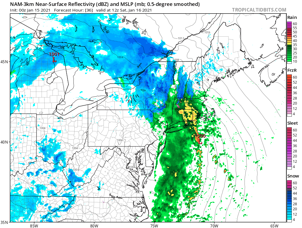
Insanely low visibility at the moment - probably the lowest I've seen in years. I took my first measurement at 9:50 and I'll be taking them on the hour. Still hovering at 32/31. Fingers crossed that diabatic cooling and heavy precip rates can fight off the low level warming that is trying to push in at the same time.
-
1
-
-
I am literally on the line right now. Just drove up from the valley where it was 36 with alternating rain/snow and no accumulation. Here at 1500' it is 32/31 and I have about 1" down so far. Started in earnest around 9am.
-
32/30 with 0.3" overnight. I'm going to be on the razor's edge with this one...
-
RGEM painting my area in the jackpot. The upslope/downslope effects during this storm could be quite extreme. Super tough call here at 1500' but I know I'll be cranking out some pretty ridiculous precip rates from about 9am-3pm and a good amount of that should be snow. This is a classic setup for my area to be near the QPF maximum.

-
52 minutes ago, PhineasC said:
Upslope signal here is a thing of beauty:
I think you're a strong candidate to jackpot from this one. With the slight tick to a colder solution, I'm feeling more confident that I will do very well during the initial thump (probably a hair better than you) but you'll make up for it with the upslope that follows while I enjoy stray flakes under a partly sunny sky.
-
1 hour ago, alex said:
Wow we are exactly at the same elevation.
I'm 50-60' lower than both of you - pretty much exactly 1500' in my location. I think we're going to pound precip rates when the LLJ slams into the eastern slope, but it's going to be a nail-biter with the rain/snow line here. Another 500' would make me feel more comfortable. I could literally see 3" of slush followed by pouring rain, or a double digit blue bomb. Definitely nervous but the trends have been positive today.
-
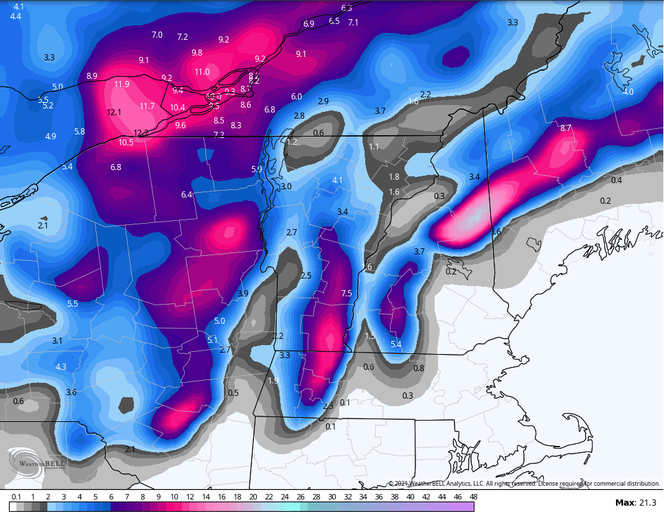
While I'm not super optimistic about the outcome of this event imby, the recreationist in me is fairly excited about the potential for the high country on the east side of Mount Washington. It looks like thermal profiles support mostly snow for the duration of the event at elevations above 3000' and potentially down to 2000'...and with a pretty robust easterly LLJ, I think there will be a period of pretty impressive snowfall rates for places from Pinkham Notch up to Hermit Lakes. Ratios won't be very impressive, but I can definitely envision up to 15" of dense base-building snow to finally open up some of the backcountry terrain on the east side of MWN (Gulf of Slides, Sherburne Ski Trails). I might finally be able to stop lapping groomers when this is over.
Good upslope potential for the Vermonters and Alex/Phin on the backside of this thing Sunday into Sunday night as well.
-
1
-
 1
1
-
-
I'm not sure I entirely buy into the idea of a changeover to rain up to 3,000' quite yet. If the Canadian/NAM solution were to verify, then yes...I agree this is a possibility. But the Euro/GFS are decidedly colder, and the Euro is actually a good snow event for the majority of the White Mountains. At 60+ hours I will hedge toward the Euro/GFS over the Canadian/NAM just about every time.
I do think that areas south of the notches and below 1500' in elevation are in trouble. This will likely be another miss for the snow-starved Mount Washington Valley, which has really only seen two significant snowfalls so far (12/17 and 1/2). I think North Conway proper is only around 12" for the season to date at this point. But I have a feeling the Canadian/NAM will hedge closer to the Euro/GFS solution as we get closer, and I'd be feeling reasonably optimistic if I were Alex and Phin right now. I'm not as confident about my immediate location.
-
2
-
-
0.5" of fluff from many hours of steady very light snow late yesterday. Could be a long wait before the next measurable now. Models have been teasing on and off for the Tuesday/Wednesday period next week, so hopefully that starts to gain some traction in the coming days. Still a wintry feel out there regardless.
-
0.3" last night brings us up to an even 22.0" on the season so far. The current snow depth is 4-5 inches.
I don't know of any reliable climo data for Jackson in particular, but the COOP in North Conway averages 20.2" through January 1st. I think I average about 1.5 times the amount of snow that falls in North Conway (120" seasonal total versus 80" in the valley) so I would presume we should be closer to 30" on the season at this point in my location. All things considered...we aren't that far off.
I think where we are really struggling is in the snowpack department. I'm pretty certain there should be more than 4-5" OTG at 1500' in the eastern Whites on January 4th, but the December thaws really prevented us from making much progress. The maximum depth I've observed all season was 8" following the 12/17 event.
-
Ended up with 5.7" out of this event. It looks like we have some opportunities to pick up an inch or two here and there over the next few days (tomorrow night then potentially again on Tuesday) which should keep things looking fresh at least. No deep arctic air in sight, but no big rain storms/thaws either. I can do without either, so I think in general we're looking far better than we have for the last few weeks.
-
Seems to be wrapping up here now. Just measured 5.7" with the last flakes coming down.
-
3
-
-
Measured 4" on the nose here in Jackson as of 8am. Currently 27F with light snow continuing. No indication of any mixing here.
-
4.0" here in Jackson as of 8am. Light snow and 26F right now. Beautiful.
-
Picked up 0.4" of new snow today. Would be negligible with an existing snowpack, but since we were previously bare it's nice to see a whitened ground again. Looks like another opportunity (locally) Thursday morning, then of course we wait to see what the weekend will bring.
-
1
-
-
8 minutes ago, BuffaloWeather said:
You've had lake snow events with quite a bit more than that since 2014. I think at least 4-5.
Yeah, I was wondering about that too!! I was thinking, "Has it really been that long since the city had a good one??" but I'm not super connected to western NY weather.
-
This is the first Christmas I have not spent in Buffalo since 2008. Picked a hell of a year to skip.
-
1 minute ago, BuffaloWeather said:
Welcome back! I remember you always posting when you came up around thanksgiving and christmas. Did you recently move to NH?
I was getting a little worried with how the models were trending but as Bumble pointed out these early season events with full length of the lake and above average lake temps usually overperform. The RGEM has been my favorite model for lake effect for a long time, its by far the most accurate.
Yes, I moved to New Hampshire in August. My new spot is at 1500' in the eastern White Mountains and averages 100-120"/year. It's a great spot for synoptic snowfall...USUALLY. We have struggled to get things going this year, but winter is long in these parts.
-
3
-
-
20 minutes ago, BuffaloWeather said:

I really appreciate your reports! I have family in Hamburg and I began telling them to expect 2-3 feet of snow back on Thursday. I am formerly 'kulaginman' operating under a new account, by the way lol.
I've been using the RGEM as my "go to" meso model recently, as that handled the recent synoptic event with insane mesoscale banding very well here in New England. If the RGEM is correct with the placement of the LES band...you should be solidly in the crosshairs until at least 5-6pm today. I would anticipate at least another 16-22" of snow in your location today. You are definitely pulling a three-footer out of this.
Enjoy it!! Yesterday's 3.34" of rain and 53-degree temps wiped out our meager snowpack here in New Hampshire.
-
1
-
-
3.34" ended up being the storm total rainfall in my location. Just narrowly pushed past the 11/30-12/1 event (3.33") to make this the largest precipitation event since I moved here in August. Too bad absolutely none of it was frozen.
It sounds like this event took an enormous toll on the mountains around here, as most of them are on delayed opening this morning. I've been skiing both on and off piste in NH for much of the last decade, and this is about as grim as I have seen this late into December. I managed to score some backcountry turns on Mount Cardigan last Wednesday thanks to the monster storm on 12/17 but this recent event has definitely eliminated any potential backcountry skiing for now. I think I'm heading over to Bretton Woods for some uphill laps on what's left of the piste later this morning.
-
Up to 3.18" of rain here in Jackson. My biggest single storm total since August was 3.33" on 11/30-12/1 so this has a fair chance of surpassing that. Temp down to 48F.
-
Up to 2.82" in the bucket now. Jackson Falls is raging.
-
Snowpack has been eradicated here. First time looking at bare ground since the morning of December 5th. Currently 53F with 2.36" of rain in the bucket so far.

January 16 2021 - Inland runner Rain/Snow/Wind
in New England
Posted
2.2" last hour for a total of 3.0" on the nose here at 1500' in Jackson. At 9am it was a mix of rain and snow and 36F in Jackson village, about 700' below me. But we are getting crushed here.