

Moderately Unstable
-
Posts
324 -
Joined
-
Last visited
Content Type
Profiles
Blogs
Forums
American Weather
Media Demo
Store
Gallery
Posts posted by Moderately Unstable
-
-
(1) Tornadoes:
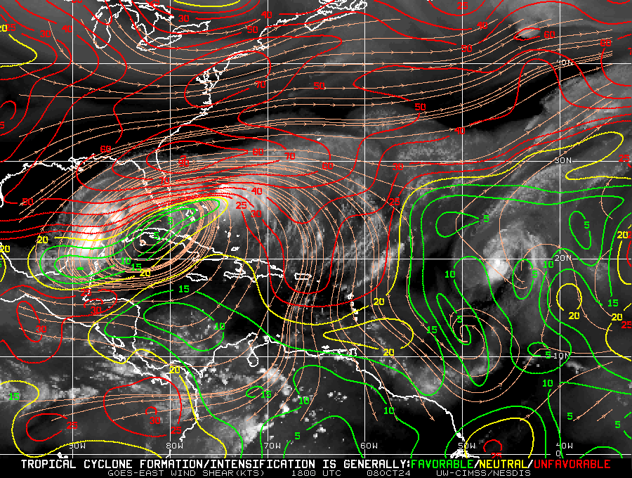
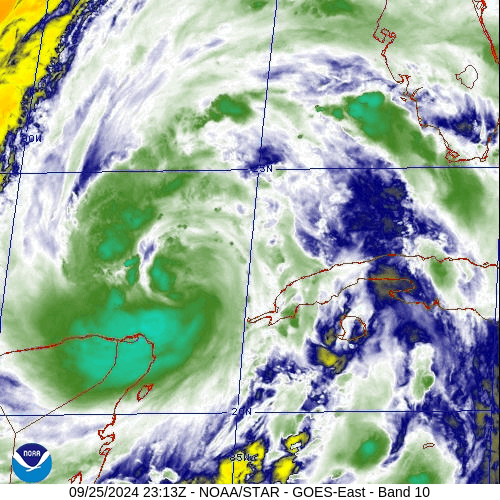
There is a baroclinic enhancement/processes going on that are raising the tornado potential leading to the notable apparent outbreak and intensity of cells. The elongated hodographs due to the RF quad of Milton are interacting with favorable jet dynamics and a warm frontal boundary. For all intents and purposes, areas of SE and central Florida may as well be in a warm sector. Also with the high pwatts/moisture, you can spin things up more easily. Overall hodographs are "meh+", but LL SRH values are extremely high - stp values supportive of EF-3 for many areas. HRRR fcst soundings and spc mesoanalysis show the various support features well. I'm still surprised by # of strong tornadoes. Violent tornadoes from hurricanes are a bit unusual. Spc did well with the 10% hatch. Certainly its own story after the storm is over. Not sure where this will fall in historical context.
(2) In general, it has been progged for a few days that the storm will come in as a weakening C3. That continues to appear accurate. It is not "making a comeback" now...and it wasn't supposed to. It's more a question of "how well it holds together" in these final hours. It has hot bath water, and upper level support, but shear is clearly unfavorable. Eye may close off temporarily but should be more open than closed. Shear and closed eyewalls are not friends. Also remember that as this occurs, precip banding will continue to trend toward the vorticity (North), versus a direct alignment of the column. That's also contributing to the wobbles. Beam height right now of E eyewall from KTBW is 9k feet. I buy the VDMs more than the TB radar for eyewall characteristics since, you know, they're there.
(3) As the mid level vort max moves north, it will and is tugging the storm north. Hard to prognosticate landfall watching radar frame by frame. Storm is interacting with sw trough. Long term motion still looks ne ...it's messy with the complex eyewall changes going on and the baroclinic interaction. I'm not on the early south landfall train right now. Still kinda seems Sarasota to Bradenton to me, but I'm leaning Sarasota.
-
 17
17
-
 5
5
-
 3
3
-
-
41 minutes ago, HKY_WX said:
The overall structure looks solid right now. Not seeing any issues of shear or dry air like last night. I think it's all systems go until about 10am tomorrow and then it will level out and slowly weaken. That said the damage may already be done. The amount of weakening is probably being overplayed too IMO.
I am seeing some minor shear effects, no dry air effects on recent IR scans. Shear vector is well enough aligned to storm motion and shear as analyzed is minor to moderate...but non-zero. At the moment the coldest convection is down shear of the the eye which means mass dumping in the eye is inferior to the strongest convection being dumped into the eye though still occurring. Clouds SW of the eye are a bit warmer than NE and have been watching that trend for a bit now. Certainly agree on lack of dry air issues. Meso vortices are visible on zoomed in high res sat imagery so the mixing of momentum and energy concentration in eyewall is fine. Does not appear to be RIing currently, seems like weak steady strengthening mixed with periods of steady state atm. Eye temp is warming, slowly. The Dvorak 910s to maybe 905 seem about right. In fairness to Milton...it is hard to RI when you're close to the mathematical maximum intensity for your environment. Curved bands look good.
MMUN radar shows a generally closed eye with a couple open blips on a few frames, with the next outer band potentially showing opening to the north (this is where HH are key - beam height/attenuation/distance etc may preclude optimal viewing of the band opposite to eyewall as seen by MMUN radar). Together, I would bet on marginal strengthening to steady state atm but another impressive presentation in general.
Hurricane hunters were 70 nm out from eye, at reporting time 22:42, traveling at 251 kts. 16 mins from the eye at that speed, so a nice close shave and a haircut. Do they make it!?! *Grabs popcorn*
-
6
-
4
-
-
Just a little bit of fun math. Currently the latest AF H hunter AC fix distance to the latest CIMISS ADT estimated center fix, is 455 nm. The WC-130J can fly at a maximum cruising speed of 360 kts, but will likely average closer to 300. The storm is moving NE, 9 knots at heading 52 degrees according to ADT, while most recent NHC motion is ENE. Integrating this together, assuming the ac has about 450 nm to fly, it's slightly under 1.5 hours ish from the first eye dropsonde (it took a few mins to compute this). This should put it there just before the 4PM CDT advisory.
Edit at 19:55Z - they're currently getting a small tailwind and are cruising at 360 kts, which is as noted close to max cruise speed. They're also now down to about 320(ish) nm, which, combined, leads to about the same arrival time (before the 4PM advisory).
-
8
-
 1
1
-
-
4 hours ago, WishingForWarmWeather said:
Question for anyone who feels like responding -
I guess I’m used to ERC from larger eyes, or ERC’s that are more disruptive instead of the meld that happened overnight - but I suppose I was expecting more wind expansion than we see.
Would you pontificate that’s more bc of the pinhole to not-pinhole-but-still-really-tiny eye, or bc of the meld, that the explanation was relatively “small” compared to what we’ve seen in the past.
Or is this more I am just not fully understanding the dynamics at play here? Or is this bc the storm was already so compact that a near double feels small? Mixture of these things?
Well, a few thoughts. First, EWRCs are complicated and an active area of research. In fact, some of the data from past hurricane hunter flights has been used for it.
Let's start with step one. This was a fairly classic EWRC. Very very strong, very small storm with extremely tight eye developing a classic distinct secondary closed outer energy maxima. But the step two is a bit more open. Does eyewall #2 "rob" eyewall #1, does eyewall #1 simply disintegrate due to energy starvation, does turbulent flow between the two eyewalls interact in a destructive manner?
Overall, we saw pressure rise to about what would be expected, I think I mentioned 930 mb in chat yesterday actually. And we did see the outer wind radii expand. As you noted, it's a small storm. As of now it is still a small storm, and yes that did likely play a role. Going from 4 nm to 16 is different to, say, 10 nm to 45. We also know EWRCs can take on different forms, as you note. This was not a merger though. We did have two distinct eyes, radar returns and IR showed eye one weakened with warming cloud tops as eye 2 closed and strengthened with symmetric lightning around that convection last night (which suggests it had relatively strong updraft rates throughout - sufficient for a good amount of charge separation that we don't see as much of in steady state hurricane environments).
EWRCs can be favorable or unfavorable. Unfavorable occur with relatively larger moisture gradients or dry air intrusions and/or increases in wind shear. Given the higher shear status early today, but lack of dry air intrusion, the EWRC here seemed fairly neutral - as shear relaxes, it will likely restrengthen as it appears to be doing now with clearing of the new eye.
This is the extent of my knowledge on the topic, others can chime in with more if they have additional insight. Did this answer your question relatively?
-
11
-
2
-
-
44 minutes ago, RU848789 said:
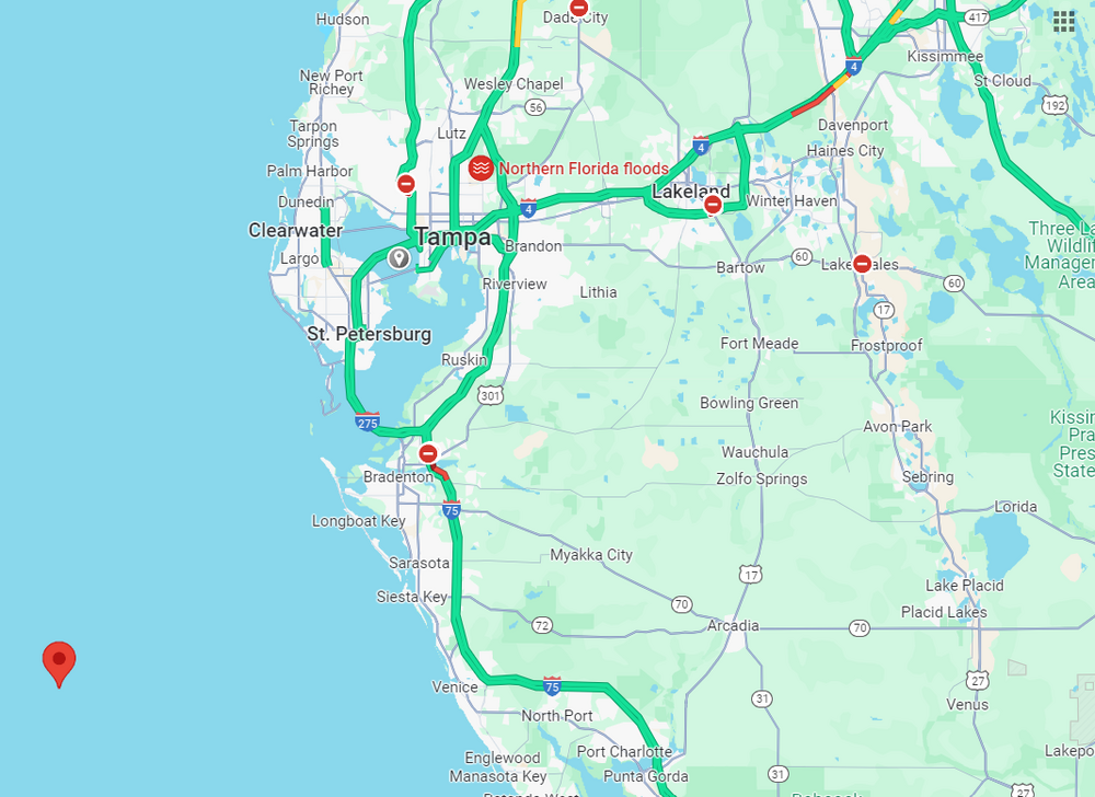
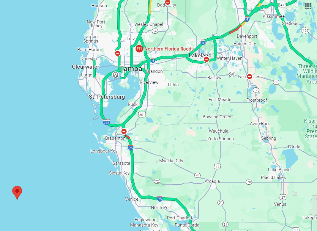
As I mentioned earlier in the thread, one of my pet peeves with the NHC is them not always providing a location/windspeed/pressure of the landfall point for the center of their track. I know they like to highlight that "users are reminded to not focus on the details of the forecast as there remains significant uncertainty in the eventual track and intensity of Milton" but I still think they should share at least the landfall forecast, as people want to know and without that info, people end up doing their own estimations of landfall location and strength, which is worse, IMO.
For example, the 11 pm advisory contains the point off the coast in the map below (27.1N 83.3W), but guessing exactly where exactly landfall will be has some uncertainty as one has to look at the track and eyeball it. It's certainly a bit south of the 5 pm track (the little grey dropped pin was the point NHC gave at 5 pm, i.e., 27.9N 82.6W), which is why I would guess Anna Maria Island, due west of Bradenton, which would mean the storm would still kind of go NE into Tampa Bay, but barely; the 11 pm track represents about a 15 mile shift SE from the track at 5pm (by my eyeball and I'd rather not be relying on my eyeballs, lol) and and another 10-20 mile shift might be enough to spare Tampa the worst surge.
The NHC "knows" the landfall point - I just wish they'd share it. As an aside, is there some service out there that actually calculates it?
It is not. Here are the facts. The more the public focuses on a line, the less they care about not being on it. Also, the NHC is not omnipotent. There are track errors. Part of their widespread success and public trust is because they de-emphasize exact paths, tell you where it's approximately going to be, paint a wide swath, and to get out of dodge. This storm is several hundred miles away. It is not physically possible to forecast whether it will go right over the bay, north, or south right now. We can try. There are trends. But anyone who tells you they know the precise coordinates - no, they don't. For Milton, the main memo is: powerful hurricane may kill you and your loved ones if you don't evacuate. The reality is, the storm could be shredded by shear, and weaker than forecast at landfall. Or, shear could affect it less than expected and it's stronger (etc). They certainly have their best guess of the eye location and track, and that type of info is communicated to EM and gov where it isn't as likely to be distorted. It's still available on the public products as you see - it just isn't the emphasis.
This is not calling you out. Most of the chat is about individual run updates. I'm mainly trying to explain why nhc doesn't go out of their way to focus on the eye's track in their public products. Private mets that do contract work for commodities get paid to do what you're asking for.
-
9
-
1
-
1
-
-
523
URNT12 KNHC 080119
VORTEX DATA MESSAGE AL142024
A. 08/01:00:30Z
B. 21.81 deg N 090.28 deg W
C. 700 mb 2319 m
D. 912 mb
E. 050 deg 13 kt
F. CLOSED
G. CO4-24
H. 135 kt
I. 345 deg 2 nm 00:59:30Z
J. 093 deg 128 kt
K. 028 deg 6 nm 00:58:30Z
L. 166 kt
M. 264 deg 3 nm 01:02:00Z
N. 356 deg 158 kt
O. 264 deg 3 nm 01:02:00Z
P. 13 C / 3062 m
Q. 22 C / 2996 m
R. 15 C / NA
S. 12345 / 7
T. 0.02 / 1 nm
U. AF302 1114A MILTON OB 12
MAX FL WIND 158 KT 264 / 3 NM 01:02:00Z
OUTER EYEWALL OPEN SW
;
-
2
-
-
13 minutes ago, USCG RS said:
We actually saw this with Hurricane Matthew. Made me ponder if ERC are actually a sign of a healthy and optimally functioning storm. The storm would go through the ERC, expand in size and increase in strength in a rather quick fashion.
Yes. You can see on the goes 16 meso 2 minute floater imagery right now the ring of concentric cloud tops colder than -80 C. That correlates to a broad zone of long and deep positive cape soundings (talking theory here). ERCs can be triggered by a couple different things - so they aren't a universal sign of health. But they do typically signify that a storm has reached maximum potential intensity for the given environment. If you have more heat energy available than the eyewall can convert into kinetic energy, you get a second eyewall. That can happen both in a great environment like this one, and a worsening environment where the storm can no longer support the intensity of the eyewall it has, from what I've observed.
Physically, when an EWRC occurs, the pressure wind relationship shifts. The kinematic and thermodynamic energy of the inner eyewall is trapped by the outer eyewall. As subsidence increases in the inner eyewall, wind speed is transferred to the outer eyewall as it contracts, with pressure rising. Thus, temporarily, we get a stronger wind speed than pressure would portend. As convection in the old eyewall ceases and the column disintegrates, the outer eyewall becomes dominant and then can mix freely and the relationship flattens again. So, in the context of a record-nearing storm, it isn't a sign of "bad health". It's simply physics. Storm can't get stronger with the eye it has, so it's going out to get a new ring.
-
12
-
14
-
1
-
-
23 minutes ago, purduewx80 said:
Yeah, double wind max evident on the east side now too. Bummer they weren’t in there when it likely peaked.
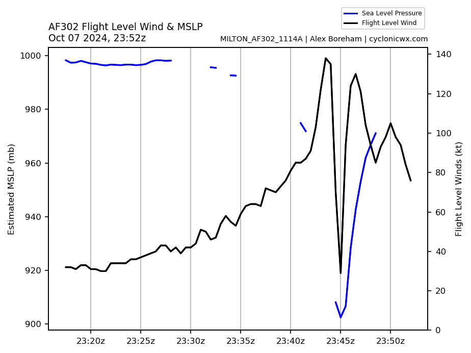
Bummer indeed. But considering we did still get an official measure of 897 mb (pending post season re anal)... it's missing for posterity but, sub 900 is unusual. Milton is only surpassed now by Rita, for intensity in GOM. That's it. It is #2. If it goes to 930 and drops down again to 920 mb tomorrow it'd still be a c5. It's physically quite difficult to get this type of pressure. Today was a show, and it's unfortunate that it portends an unfortunate Floridian reality. It does seem likely to see re- strengthening after an EWRC with the favorable short term environment. What is going to be interesting is watching the overall angular momentum change there. Again, if we conserve energy and broaden the wind field, and we then begin to decrease pressure again and contract the new eye, the overall fetch of the storm should increase.
//
Worked with Tomer years ago. Smart dude. Really happy he's done so well.
-
9
-
-
43 minutes ago, cardinalland said:
well first atlantic storm in the 800s since i started tracking.
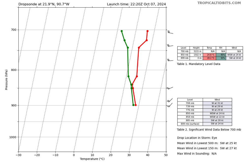
Few bites from dropsonde(s) (ne eyewall and eye). (1) They dropped in ne eyewall, and the sonde rotated halfway around the eye. (2) Still dumping mass at the upper levels, cloud tops are still cooling still deepening, (3) mean LL wind in bottom 150 meters of eyewall is 200 mph. You can expect some of that is mixing to surface with this storm structure. Thus, I would presume they go with 190 mph on an update. You may have noticed that surface wind speeds shown on nhc products tend to be a blend of the lowest 150 meters, not specifically the surface wind speed.
37 minutes ago, RU848789 said:Not really official. Official would be Levi, Tomer, NHC staff, hurricane hunter staff, other experts on hurricanes. Not a diss - but since this forum is likely being viewed by thousands right now (not just members), some of whom are using this for decision making...be careful about official source citing.
37 minutes ago, Eduardo said:“[M]aking an attempt” is accurate though, IIRC, we have seen some storms during the past few seasons that featured double- and even triple-maxima without completing a full ERC and weakening accordingly. Maybe someone else can chime in and double-check my memory though.
Either way, ERC’s remain incredibly hard to predict.
This is a small storm at near the maximum possible pressure attainable. Modeling, experts, and forum Mets have all generally had consensus that we will see an ERC. One will occur (or more). In sum, once we reach the maximum possible intensity for a given eyewall and the inner eyewall contracts to maximum possible extent, the outer bands strengthen and close. The closure initiates an ERC. Given the environment and near-record pressure, forecasting an ERC is not a reach (it frankly doesn't require a lot of expertise). When this occurs, conservation of angular momentum applies. Storm wind radii increase, wind speed decreases, angular momentum remains conserved-(ish with some caveats).
18 minutes ago, WishingForWarmWeather said:I have to believe the little oscillations I’m seeing in some of these loops is the precursor to an ERC.
Edit to add: who knows at this point. I honestly thought the radar out of Mexico earlier showed the beginning of the band that would start it but that solid inner eye has really held on. I just remember Rita? Or Wilma? One of them. Started oscillating around before the ERC.
ERCs take time. Many hours. So as Levi said in a post quoted a bit ago, even if there are minor hints of one, it isn't there yet.
One last thought. "Historic" is a word I think that is overused in meteorology - this forum is guilty of it, I am guilty of it. But, I think where this is right now you have to just appreciate that this is history. Right now. You're watching it. It will be in tropical meteorology class references in the future.
-
8
-
3
-
16
-
-
From the plan of the day, it appears they
 plan to launch 2 unmanned ac systems into the eye. One at 925Z on the 8th, one at 2115Z on the 8th:
(Quoting from the plan of the day):
REMARKS:
A. A NAVY P-3 WILL BE DROPPING 25 BUOYS ALONG THE WEST COAST
OF THE FLORIDA PENINSULA AHEAD OF HURRICANE MILTON TODAY,
BEGINNING AT APPROXIMATELY 07/1800Z NEAR 28.5N 83.3W,
SOUTHWARD TO APPROXIMATELY 25.0N 81.9W AND THEN NORTHWARD,
ENDING AT APPROXIMATELY 07/2100Z NEAR 27.8N 83.5W.
B. DURING THE NOAA 43 MISSION TASKED IN TCPOD 24-128 FOR THE
08/1200Z SYNOPTIC TIME, ONE SMALL UAS IS PLANNED FOR
RELEASE AT IN THE CENTER OF MILTON AT APPROXIMATELY
08/0925Z. IT WILL OPERATE AT OR BELOW 5,000 FT FOR
ABOUT 1 TO 1.5 HOURS.
C. DURING THE NOAA 42 MISSION TASKED ABOVE, ONE SMALL UAS
IS PLANNED FOR RELEASE IN MILTON'S CENTER AT APPROXIMATELY
08/2115Z. IT WILL OPERATE AT OR BELOW 5,000 FT FOR
ABOUT 1 TO 1.5 HOURS.
-
1
-
-
14 minutes ago, Wannabehippie said:
I wonder if the birds were seen visually, or picked up on radar on the plane.
Fair question but typically birds are reported if seen visually in aviation. Commercial ac also have onboard radar these days (to avoid microbursts and hail mainly). To keep on topic - for purposes of this storm, it's likely visual confirmation. Birds would show up as a radar reflectivity return but you couldn't identify them as "flock of birds" via radar alone. They saw them.
Also fun fact for the group, NOAA9 appears to have launched. It is possible we will be watching some new records in the next few hours. Edit: appears that we have to wait until 1845 for TEAL73 to launch for the next LL recon.
-
7
-
-
1 minute ago, Wannabehippie said:
I wonder where those birds got dragged in from. The Yucatan?
Most recent NHC report. 175mph winds. Can those increase any further today, more pressure drops? This is absolutely insane with what they were just a few hours ago.
1:00 PM CDT Mon Oct 7
Location: 21.7°N 91.3°W
Moving: E at 9 mph
Min pressure: 911 mb
Max sustained: 175 mpWell, with 175 mph winds, we're at an EF-4 tornado intensity...for reference, and around to a touch below the speed a commercial jet takes off at. At such speeds, a lot of stuff gets pulled in. What is notable is that for the plane to have seen birds, they would need to be relatively close to the plane. Bird types were not reported, but bird strikes can take out aircraft engines. They are lucky they did not hit the birds.
-
5
-
-
6 minutes ago, allgame830 said:
What is the lowest possible pressure in the gulf? I remember seeing information a while back that showed this.
Well, *on record* that would be hurricane Rita. At a comfortable 895 mb. We won't be going into that department here, but, I am on the Kool-Aid train that this does ratchet itself up a lot. I somewhat despise prognosticating specific mb intensities. Please allow me to completely ignore and undercut that by saying I think this will peak between 925-935 mb.
-
2
-
-
9 minutes ago, BYG Jacob said:
982 on the dropsonde. The only issue I can see are the highest rain rates are in a band outside the developing eyewall
Possible. NOAA3 just went through, so we will have 2 data points prior to the 8pm advisory. Would be nice to be able to see the radar on the plane!
Edit: 8pm nhc is at 981. So, slightly less than 1mb/hr deepening since the last recon. There's no big dry air issue on wv, probably just core dynamics. VDM shows eyewall is open NW-NE. That's probably sufficient.
-
5
-
-
979 extrap on the recon. Last VDM was at 18:43. That places it at a slightly slower intensification rate since last recon. Something between 1.06-1.41 mb/hr average deepening rate depending on what the sounding data pulls up (eg 980-978). Based on current satellite, probably continued to deepen for a bit after last recon and has been a notch closer to steady state recently. Still, getting stronger.
-
3
-
-
4 minutes ago, andyhb said:
Kind of leaning towards this one underperforming given the magnitude of dry air and shear that begins to influence it as it moves closer to landfall. Environment is going to become very hostile and we should see rapid weakening from whatever the peak is.
I agree although I think underperformance is relative. The degree of vort displacement and dissolution on the latest regional models and dry air entrainment seem overdone. It's also certainly looking likely to achieve quite "high end" in the next couple days. Small storm in good spot. The decoupling of the LL and mid level wind fields and degree of dry air entrainment near landfall are somewhat hard to believe...the HMON shreds it to bits on approach to an unusually robust extent and probably one that doesn't hold.
Ultimately I think the timing of the incoming trough and jet streak (still wobbling a bit run to run on the 2 pvu progs on the globals in depth and in southerly extent) along with the eventual approach angle (W-E vs SW-NE) are going to factor in - without those nailed down, there will be some changes in the next couple of days. Still, the main memo is, this will not landfall at peak intensity. Likely situation here is continued RI up to c4 and slower further increase to peak at c5, EWRC with slightly less favorable environment and other parameters increasing the size of the storm but dropping winds with minor reduction in symmetry, shear increases on approach leading to a northerly displacement of the vort max and wind fields, with ensuing tilting of the column netting a storm that "underperforms" with wind - more strong gusts than sustained. Intensity wise, I think it comes in as a weakening 3 with a large but asymmetrical wind field and a (relatively) dry southerly half.
However - I think this southerly jog is not actually a good thing intensity wise - the shear axis and jet are north. Arguably the less time the storm spends in high shear, the stronger it will remain on approach. That's part of why I don't buy the regionals that fully shred it and would make it a modest 2. If you assume a NE track on approach, it threads the needle just a touch more and it's still likely a low end major - probably why nhc is going with that in the current forecast.
This storm is not Helene. E.g, not every storm is storm of the century even if it does become a c5 over the open gom. The issue, I think, is that a lot of the zones here as articulated at length...are messes right now from Helene. And while the current consensus is just S of Tampa Bay, which would spare them a bit, we are several days out with a fair degree of track forecast spread. Tampa Bay gets lucky quite frequently. I'm not sure they'll be lucky this time, even if the storm is weakening, as impacts will be exacerbated by antecedent rainfall and existing damage to structures. Also factoring in a slightly more ne approach angle, they will still get a period of onshore flow. Overall - TB is still in cross hairs right now, and some of the guidance still takes the center N of the city.
-
16
-
3
-
3
-
-
The main noticable change on IR recently (by my eye) is in the LL wv channel. Within the last ~45-60 mins, seeing some better angular momentum with the cells firing along the eyewall itself and better richer coverage of wet air. Obviously, with a storm this large there's a lot of mass to accelerate. The physics remain good heading into the nocturnal convective peak. Water is hot, hot water is deep, UL ventilation is excellent. Often once you see that sort of classic rotation around the eyewall, you're looking at significant intensification. I'm still wrapping my head around the amount of angular momentum the storm has - consider the spatial scope of this thing, and its speed and depth. Impressive.
-
3
-
2
-
1
-
-
4 minutes ago, weatherwiz said:
Holy crap...I hope that is just some sort of error.
I mean, sampling the inbound side's returns, I'm seeing plenty of 180s to 190s with a spot of 210 and 222. So, I don't think it's an error. Mesovorts around an eye like that. Does still seem to be strengthening. Phew.
-
1
-
-
17 minutes ago, hawkeye_wx said:
Could there be the beginning of an eyewall replacement cycle going on? Satellite shows what looks like an outer ring popping around the north side of the core.
Edit: The Cuba radar doesn't really suggest that to me, so maybe not.
Current take: no. Too early. Eye too big, storm itself still finalizing getting its act together and has improved substantially in presentation in the last hour vis a vis clear enhancement of angular momentum and closure of the eyewall. Sat presentation continues to improve, best to look at medium term trends rather than minute to minute on H's.
-
3
-
1
-
-
1 hour ago, Chreeyiss said:
Obviously you’re the met, so your opinion is much better informed than mine, but it seems to me that if if our intensity scale is to continue relying heavily on damage produced over other indicators, that the scale needs to be updated with more non-urban damage indicators for EF4+ tornadoes, rather than a downward adjustment of winds in the ef5 category. In concept, it doesn’t make a whole lot of sense that a tornado’s intensity is only as strong as the building it hits (or doesn’t hit) but even with improvements in technology, it’s still the best we’ve got. Tornadoes predominantly hit rural or even unpopulated areas, and if tornado intensity is going to continue to be evaluated by this methodology, I would think the next logical step in improving the scale would be to accommodate that fact better.
The NIST slideshow about Joplin that was posted above makes note of the large amount of subjectivity that comes into play when evaluating unconventional damage indicators due to construction methods that can’t generate an ef5 rating. I’m sure Tim’s statement was made on the fly, but using two tornadoes that were clearly well above the F5 threshold as the benchmark for 201mph winds doesn’t seem like a fair comparison to me.
If I had any say in the matter, I personally would only advocate for lowering the wind threshold if structural engineering studies determined that what is generally considered ef5 damage was produced at lower wind speeds, or if we were to lower the standard for what is considered ef5 damage.
Let me know if my line of thinking here isn’t correct.
Nope, we're on the same page. We need to have a 3rd revision to the EF scale. Specifically we need to be able to come up with valid damage indicators for, as you note, rural areas. One of the main concepts of the EF scale when it was introduced was that it was supposed to retain continuity with the old rating system. E.g. the numerical wind speed estimates were going to change, but, the same type of damage on the F scale was intended to be rated the same on the EF scale...just with more accurate wind estimates and more specific damage indicators. That isn't currently happening imho. An F5 of old does not seem to be an EF5 now. I do think there's some merit to the chatter going around about the rating still being preliminary (other 190 mph tornadoes have indeed been upgraded to 200...it really is a tiny difference). However, if they don't upgrade, I hope they produce a very detailed report (I'm sure they will), that explains all of the factors that got them to their conclusion. And I hope that report doesn't say "we thought there could be EF-5 damage, but, couldn't find damage indicators to support it". Conversely, if they say, "radar estimates along with contemporary research into tornado intensities as related to debris height, vrot, wind tunnel testing and other physical studies, suggest this tornado was demonstrably weaker than EF5s on record because of A, B, C", I would be ok with that. At the moment though, since the damage rating is preliminary, it may yet get upgraded. Either way....we need a better way to rate rural tornadoes. There should also be some type of discussion amongst the research community at this juncture as to whether our radar measurements have grown accurate enough to be allowed to "factor in" to the rating. Take El Reno. We know it was a 5, by 100 mph. Because DOWs measured that. But it's a 3 due to the damage indicator problem. That in my view becomes an actual research problem. If I'm were to do a tornado study, and I am pulling up atmospheric conditions present for "F5" tornadoes, trying to draw conclusions...my conclusions will be flawed if the ratings depend on the type of structures being impacted. Meteorologically, the atmosphere does not care if there's a city or a field below it. But the rating system does, which would lead to biased results (potentially). At the least, it gives researchers an incorrect sample population and incorrectly classifies the rarity or lack thereof of specific tornadic intensities. Our current scale "favors" EF3s and EF4s, when we're talking major damage, and that's solely due to the design of the damage indicator system. I'm not saying every high end EF4 should be a 5, but this is the latest of several tornadoes that really hint at top end damage, and aren't getting that top end rating.
-
6
-
-
Hm. Well, it's splitting hairs to some degree I think (10mph from EF-5); very similar overall "thinking" to Bassfield, which as many recall we all were discussing an EF-5 rating as well.
I actually have a counter-thought with respect to Tim Marshall. What if he gets called in when the NWS team *doesn't* have the damage indicators it needs to make its own assessment and needs an outside expert to review things that have been destroyed and basically assign a damage indicator rating on the fly? Many have pointed out that the structures on path wouldn't be able to generate an EF-5 rating. My interpretation when they called in the "experts" was that, they had damage that they were struggling to classify. Otherwise, why bring in said experts? Yes high ratings are important publicly speaking--but they're the sole discretion of the office in the affected CWA.
I also wonder, would those 2011 ratings have changed? Or, were there genuinely different building materials or other factors? I feel like, as much as we are kind of trashing tim (et al) right now, he obviously *is* an expert on tornado intensity. I'd be curious to understand the process Tim himself goes through when he does these evals. Does he incorporate Doppler radar data concurrent to the location he's evaluating? How does he and the NWS evaluate something that is "beyond destroyed"? What I mean is, I picture Tim coming in to answer the question, "this well built home was slabbed but xyz was not built correctly so there's XYZ ambiguity, is there anything you can see in the wreckage that looks like it would take a higher wind speed to be able to do THAT destruction?". One thing I've read about EF-5 damage is that the debris is often "pulverized" into a "fine powder" with "little recognizable from the original structure". Of course if that is the bar, there are EF-5s and F5s that would under our current rating scheme get downgraded.
All this said, my gut instinct is, hard as it is to believe, had Tim and co found some type of incredible damage as it were, they could still have issued an EF-5 rating on path. That's why they call in the experts. Arguably, we probably rated tornadoes overly agressive in the past, as opposed to rating them too-low now. Various numerics during the tornado including vrot had many on Twitter and a couple on here calling it EF-4 strength (while noting, if it were a bit closer to higher STPs and more population it'd be a 5). But since it wasn't, technically the radar does kinda track with a very high end 4 ( 30k feet debris loft is significant though--but could also be a function of the strength of the overall supercell's organization, which makes sense for many reasons and is what enabled such a strong tornado in the first place).
My final thought is, based on all the above, this would've been a 5 in 2011, 2007, before the EF scale (etc). The reason it isn't now feels like it is less to do with a change in *damage*, instead, we have a much better understanding of what *wind speed* is required to *produce* given damage (and for what duration and at what angle that wind must impinge on the structure or object in question). We understand now that things like forward speed, and angle of approach, can influence damage to structures. Therefore, I'd argue that the *windspeed* estimate is probably right, and the scale itself might need to be tweaked. We all know, EF5 means "incredible" and "catastrophic" damage. This IS that damage. It is just that. Catastrophic. And not to split hairs but it's more than "Devastating". I'd argue, devastating means everything is destroyed but it doesn't look like entire towns were model cities that had been carelessly thrown off the end of a high table by a child. Particularly what I saw coming out of Bremen.
I therefore suggest we reconsider our rating criteria, by reducing the wind speed threshold required for EF5 ratings. The point of the rating is to inform the severity. This is top tier severity, it should have a top tier rating. If 190 mph winds do this damage, 190 should be a 5.
-
1
-
1
-
-
Fair point. Partly because of what I have been reading on twitter. Perhaps I mis-worded what I meant, but that basically was more of this is not conceptually something no one has seen. I didn't mean it was something that had been seen in December, for this path length (etc etc). Those things are all valid. I meant, from a pure damage standpoint, we have seen damage similar to this before. It is very high end, yes. But when I read twitter posts that exclaim (and I'm not talking about the folks that are actually in person taking photos), that this has never been seen, that's what I meant. I've seen this with strong hurricanes and other severe weather a bunch. Every massive high end event is *the* worst event, rather than, a very very bad event amongst other very very bad events. Which is fine if it is the worst event in that context, but that's a high bar to clear, and one that hasn't yet been officially proven (even though yes, the images are bad).
-
1
-
-
Right--so my point was not that the event wasn't bad, nor was I even saying it wasn't an EF5. I also wasn't trying to come off as condescending. I'm not sure who exactly I was being condescending towards, particularly on this forum, but I digress.
I found a couple of useful links, I shared them, and I copied and emphasized some of what was written. I'm not entirely sure how well they are known, that was why I posted them in the first place. Yes, some people do know that, others don't.
My main "point" in the essay, is to wait for the survey results. Given that Paducah has already been out, and has assigned a range between 158 and 206, they (for whatever reason), are not in the unequivocal camp. That gives a range of 6 mph for EF5, and, 35 for EF4. That's preliminary, but, that's why I wrote the post.
-
I post this at my own peril (cue the comparisons of images to the scale), but https://www.spc.noaa.gov/efscale/ef-scale.html
There's your degrees of damage scale. Wondering what wind is needed to cause X damage? There's your link.
For a single family home: https://www.spc.noaa.gov/efscale/2.html
-Slabbed home bounds are expected to require 200 mph winds. BUT, and this is IMPORTANT for everyone on here: the lower bound is *165* mph (that is not an EF5, which begins at 200).
For a warehouse: https://www.spc.noaa.gov/efscale/23.html
-Complete destruction does NOT require an EF-5. Note: industrial buildings tend to fare WORSE than well built homes in a tornado. They are large, typically presenting a large and flat surface area orthogonal to the wind direction, and have vast, cavernous interiors. Translation: an industrial building being torn apart is actually less indicative of an EF-5 than a masonry structure, well built home, or similar.
-Structural deformation of a high or mid rise building, generally correlates to a case-closed EF 5 designation. Such as the Mercy medical center in Joplin.
-Hardwood trees debark at an expected wind speed of 143, (low EF 3).-For an institutional building like the Grays county courthouse, https://www.spc.noaa.gov/efscale/20.html I would suggest that the DOD is 10, corresponding to a windspeed of 148 (EF3) ranging from 127 (EF2) to 172 (EF4). Other areas on path have worse damage. But that's high profile.
Quoting from: https://www.weather.gov/ama/damagesurveys , bolding mine:
QuoteLet’s look at an example to help tie everything together. For an interactive demonstration, this link will be very helpful: http://www.spc.noaa.gov/efscale/ef-scale.html. A tornado strikes a house, causing the entire roof to be blown off, but all the walls remain standing. The survey team will first assign a damage indicator of 2 since this is a one- or two-family residence. The description of the damage corresponds best to a degree of damage of 6 (http://www.spc.noaa.gov/efscale/2.html). After careful inspection of the construction quality, it is observed that the ceiling joust was fastened with rafter clips to exterior walls, which meets code. Therefore, the survey team assigns an expected wind speed of 122 mph. Based on this wind speed, the team assigns the tornado a rating of EF-2 with winds between 111-135 mph.
To translate, the survey team needs to evaluate (in a lot more detail than we can with photos), HOW the homes were built, and how they were fastened to their foundations. Did they meet code? What did the radar presentation look like at the time the tornado was over the structure? What did people in the building(s) experience as the tornado went through? How were things fastened together? How long were tornadic winds impacting the structure? They'll also look for office buildings of mid-range height (I doubt there's any high rise buildings on the path of this tornado). The key to those is looking for structural deformation. E.g. well built concrete and steel buildings that have BENT out of shape. Note: the water tower that collapsed DOES NOT qualify for that. It's a freestanding structure, and the deformation seen is almost certainly a result of impact with the ground and being tossed around along the ground, while presumably filled with water versus the wind itself bending the steel. And therein lies the difference. Ever dropped a full plastic water bottle on the ground (or a metal one) from height? It breaks, right? How about an empty one? Does that break? Nope. If you blow your water bottle with a leaf blower does it deform? Also no, but it probably would blast away into your neighbors yard and make them think you're pretty weird. My point, the bent steel of the water tower is due to the collapse, not the wind. But, if the team finds actual steel in a building bent by the wind, that's different.
//
For more (albeit old reading): https://training.weather.gov/wdtd/courses/EF-scale/lesson2/FinalNWSF-scaleAssessmentGuide.pdf
This is prior to the switch to the EF scale but the explanations still apply...
From that, bolding mine:
P.30: "Giving a tornado an F5 rating is probably more contentious than it should be; in general, more scrutiny is given to an F5 rating than to an F4 rating. In fact, the reluctance to give tornadoes an F5 rating might well cause some events to be rated F4 that might well have been deserving of the highest rating. In effect, proposing an F5 rating focuses so much attention on the issue that storm survey teams will be hesitant to rate an event at that level unless they find the strongest possible evidence. Most F5-rated tornadoes have hit populated areas; a tornado passing through open country is unlikely to be given the highest rating. In the event a tornado hits a populated area, survey teams can be under some substantial pressure to make an assessment before they have had time to give the issue the careful consideration it deserves. Formally, by the Fujita scale criteria, F5 damage to a frame home not only leaves no interior walls standing, but the debris from the home is swept away, leaving essentially a bare foundation. This sort of “incredible” destruction is as total as it is possible to be; it leaves essentially nothing of the home but a slab or an empty foundation. This criterion would seem to be relatively easy to evaluate but for a number of complicating factors. As always, the structural integrity of the home prior to being hit is a critical element. When distinguishing F5 damage from lesser intensity storms, the attachments along the load path are potential weak points. As already noted, further complicating the issue is the question of the duration of the tornadic winds. The 27 May 1997 tornado that hit Jarrell, Texas, left a number of homes in a particular subdivision with nothing left but empty slabs (Fig. 27).
Even the debris was blown far away, making the F5 rating an apparently easy decision. However, a post-event survey by structural engineers revealed that there was some variability in the attachments. Some homes were rather strongly attached to their slab foundations, whereas others were not. Beyond that, however, an important question became the duration of the strong winds – this was a large, relatively slow-moving tornado (the damage path was estimated to be roughly 3/4 mile wide, moving at 5-10 mph). At the observed speed, homes would experience damaging winds for 5-10 minutes. Not only would the damaging winds have more time to put structures under stress, but the long duration would be more likely to sweep away the debris than if the tornadic windspeeds been of lesser duration. Moreover, this subdivision was relatively isolated, surrounded by mostly open country. In the case of the tornado that hit the Oklahoma City, Oklahoma, metropolitan area on 3 May 1999, some of the F5-rated damage occurred in the suburb of Moore, Oklahoma. In this case, the tornado moved in from other populated areas, and its debris load was already substantial as it entered Moore. The result (Fig. 28) was large piles of rubble remaining on empty slab foundations. The tornado damage path was about 1/2 mile wide at this point and the tornado was moving around 35 mph. The damaging winds would last only about a minute in such a storm, and if debris from a particular home was swept away, other debris would fall in its place. In fact, that is just what was observed during a post-storm survey – the debris left in a particular location in the F5-rated damage area in Moore did not come from that location, but arrived from areas hit previously by the tornado. Hence, the absence of slabs swept clean of debris could not be taken as evidence of intensity levels below that of F5."
So, the duration of tornadic wind matters too. Here, we have a 1/2-3/4 mile wide tornado. Calculating the amount of time it would be impacting a structure matters when calculating the wind speeds.
Note, with respect to slabbed homes, an *EF-3* can slab an *un* anchored home.
Overall, while I continue to believe this is a low end EF-5 tornado based on the totality of images across various communities, radar data, and environmental parameters, it is NOT as "case closed" as some on here (and on twitter) have made it out to be (and that's why this is a process). Also, with respect to myriad comments of "oh gosh I've never seen this", mostly on twitter--yes you have. And you said the same thing after Moore, Joplin (etc) if you were old enough to be following those events when they occurred. Or Tuscaloosa, Bassfield, Philadelphia (MI) etc. This is not the strongest tornado ever recorded. Period. You've got El Reno (an "EF3" but with measured 300+ mph winds and 2.6 mile width with various sub vortices the size of "regular" tornadoes traveling in trochoidal oscillation), the Moore twisters, obviously Joplin, and many others, that, FWIW, had this degree of damage or WORSE. The length of path, time of year, fatality count, and overall significance of this/these tornado(es) is/are historic, and that will be true regardless of whether it is an EF-4, or EF-5. But, it is not the worst damage most of us have seen. It's BAD--no question. But we don't need to over-dramatize it. We've seen the pictures. What's left is for the experts to physically review the places in those pictures in detail, and determine if those slabbed homes would've blown apart with EF3-EF4 winds, or if that would've required that 200mph wind to do that damage. We can't know that from any picture or video, because that information comes from the blueprints and related original construction documents of the home or structure or at least close physical analysis of the debris to find the relevant joints and fasteners (which, I shouldn't have to specify, we don't have access to).
On the other hand, there's also a semi, non-scientific empirical relationship between number of fatalities and EF rating. Generally, the "worst" and most fatal tornadoes are EF-5s. That's because despite the best possible warnings, which this storm did have, at the end of the day, EF-5 tornadoes are in some residences or structures not survivable. If you don't have the right underground structure to protect you, you will die, even in a well built house, and with prior knowledge that the tornado is approaching and having taken appropriate actions (covering yourself with pillows or other materials in an interior room on the lowest floor). Stand in front of a jet engine at takeoff thrust with a pile of wood beams, nails, bricks, cars, etc between you and it: you wouldn't fare so well. If your home gets blown away, you're in that environment.
Of course, being a nighttime, December, tornado, didn't help. That is not the fault of the NWS, or TV mets though, as I've seen tossed around a bit (also mainly on Twitter). They did their job. Have you seen the videos of people driving on the highway, in broad daylight, a quarter mile from a giant wedge tornado? I sure have. You think they were expert chasers or mets that knew the direction the tornado was moving and that it definitely wouldn't hit them? I don't. Have you watched your friends and coworkers ignore tornado warnings (and obviously severe thunderstorm warnings) that are ringing their phone? I have. So have you. Even when the warning says a tornado is on the ground? Yep. People continue along as though nothing is happening. At the end of the day, meteorologists can only warn so much. If people choose to ignore every possible warning, including WEAs, not much more can be done after that. People act (not just wrt tornadoes but in general), when they make a personal connection between information and an imaginable threat to themselves. If someone can't imagine themselves actually being hit by a tornado, and, killed, they won't take action to protect themselves. Fear drives safety behaviors in this case. Fear takes understanding of the threat, and recognition that, yes, it can happen to you.
The link I left for the old training doc contains a plethora of helpful information that can inform you about all that goes into damage assessments, both scientifically and with respect to the psychology of a public wanting answers. Things I didn't copy over but are include good explanations for HOW things are damaged during tornadoes (through both wind action and projectile action), and basically any other question you can think of that you want answered regarding tornadoes and damage assessments (that IS the (old) training doc after all).
-
 2
2
-

Major Hurricane Milton
in Tropical Headquarters
Posted
I buy what you're selling. It's tricky because the modeling suggests LL sfc circulation lagging a bit behind the radar returns close to landfall, and we also have the chance for a slight east tick. If the dynamics of the eye remain as they are now and you extrapolate fairly linearly... I'd take Holmes Beach/Cortez. It's certainly "in the ballpark" at this stage.