

SUNYGRAD
-
Posts
39 -
Joined
-
Last visited
Content Type
Profiles
Blogs
Forums
American Weather
Media Demo
Store
Gallery
Posts posted by SUNYGRAD
-
-
2 minutes ago, BG_Slick said:
main batch of precipitation has moved through. Only light rain now. Looks like maybe .10 to .15 accrual on trees. Sleet seemed to help and temps went above freezing during heavier rain (latent heat release?) Hopefully we can melt these trees off before temps drop again. (32.5 / 31)
Probably dynamic cooling.
-
sleet and freezing rain in Triad area.
-
-
I think one (forecaster) should consider the convective component of models and interpretation of types of precipitation.

-
3 minutes ago, griteater said:
One thing to think about with respect to sleet vs freezing rain when looking at soundings...the general rule is that once the warm layer exceeds +3C, the snowflake dropping down will completely melt (instead of partial melting of the snowflake when the warm layer is between +1C and +3C). Once full melting of the snowflake occurs, the raindrop can't refreeze back into sleet because it no longer has ice nuclei to refreeze onto. As long as the snowflake only partially melts, it can refreeze back into sleet because it still has ice nuclei contained in it.
See the bolded text below from: https://www.mentalfloss.com/article/91745/7-wintery-facts-about-ice-freezing-rain-and-sleet
Freezing rain forms when there’s an inversion layer present during a winter storm. An inversion layer occurs when a layer of warm air gets sandwiched between two colder air masses. Snowflakes fall through the warm layer and completely melt before reentering the subfreezing air near the surface. This newly formed raindrop can’t freeze back into ice because it doesn’t have a nucleus around which to freeze, so the raindrop becomes supercooled, meaning it remains in liquid state even as its temperature drops below freezing. Once the supercooled raindrop reaches the ground, the water instantly freezes into ice.
-
 1
1
-
-
-
-
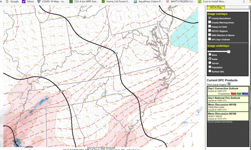
Something to keep an eye too leading into this evening. Temperature advection at 925 (below).
-
1
-
-
4 minutes ago, SUNYGRAD said:
NAM3k is lightly cooler overall at 18z at 850 than above depiction.
NAM 3k running close or a little warmer with pocket of warmer temps in SW NC. It depends upon sounding location that you pick.
-
13 minutes ago, strongwxnc said:
925
850
NAM3k is lightly cooler overall at 18z at 850 than above depiction.
-
1
-
-
1 hour ago, hickory said:
If we were to compare this to past events what are we looking at? I know each event is different, but I’m curious. For example if you live in the Piedmont Triad could this be as bad as 2002? I consider 2002 to be the benchmark for ice storms.

-
1
-
 2
2
-
-
From RAH discussion this morning. LOL
The great Appalachian chain has not moved that I have noticed (even
with the Sparta earthquakes and tremors this year). So, unless the
high becomes centered to our NNE (arctic air air will not roll down
the eastern seaboard into the Carolina`s). It will stay west of the
Appalachians.
-
2
-
1
-
 6
6
-
-
17 minutes ago, BornAgain13 said:
Yep I just asked Brad P , he said the model he used in the post is the IBM GRAF Model... anyone know anything about this model? @msuwx is it accurate?
if interested in reading material. AMD, Cray, Nvidia Behind Massive NCAR Supercomputer Upgrade (nextplatform.com)
-
IBM GRAF has done fairly well in some the past NE storms, but I do not access to the model or any statistics. Just my observations.
-
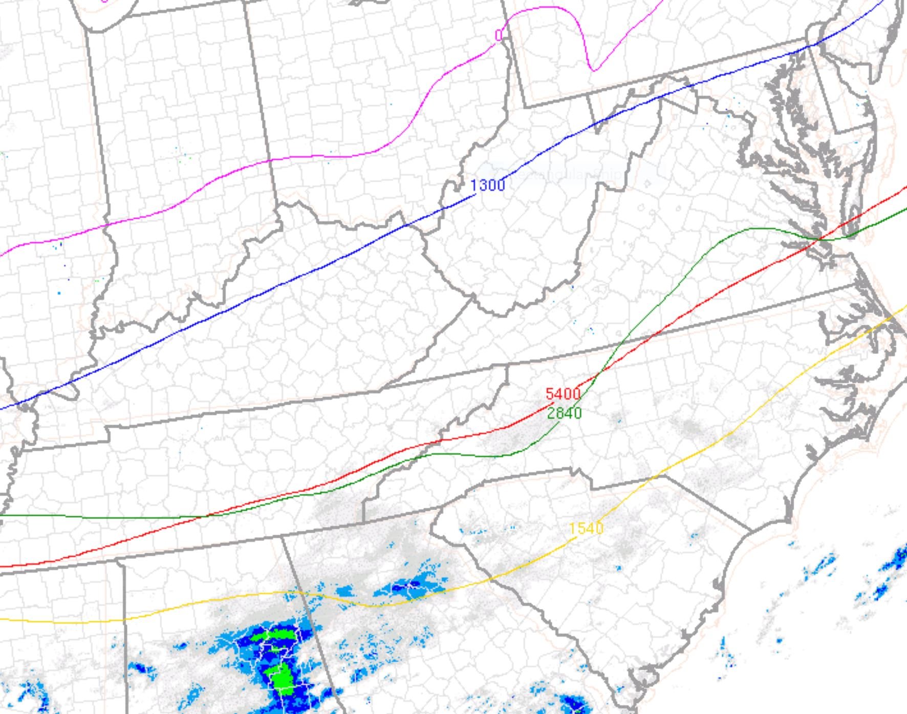
4 hours ago, gritsnc said:
Keep any eye on this next few hours. Critical thickness. It will be interesting to see if the 1000-700 dips some-
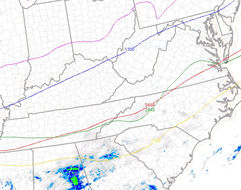
-
1 hour ago, HKY1894 said:
Every model at 6z is big improvement from 0z cycle. Great trends The gfs looks great

-
1
-
-
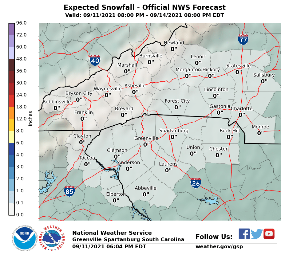
14 minutes ago, Met1985 said:
GSP is always solid. So far so good.
They have done well in past. Tough forecast
-
1
-
-
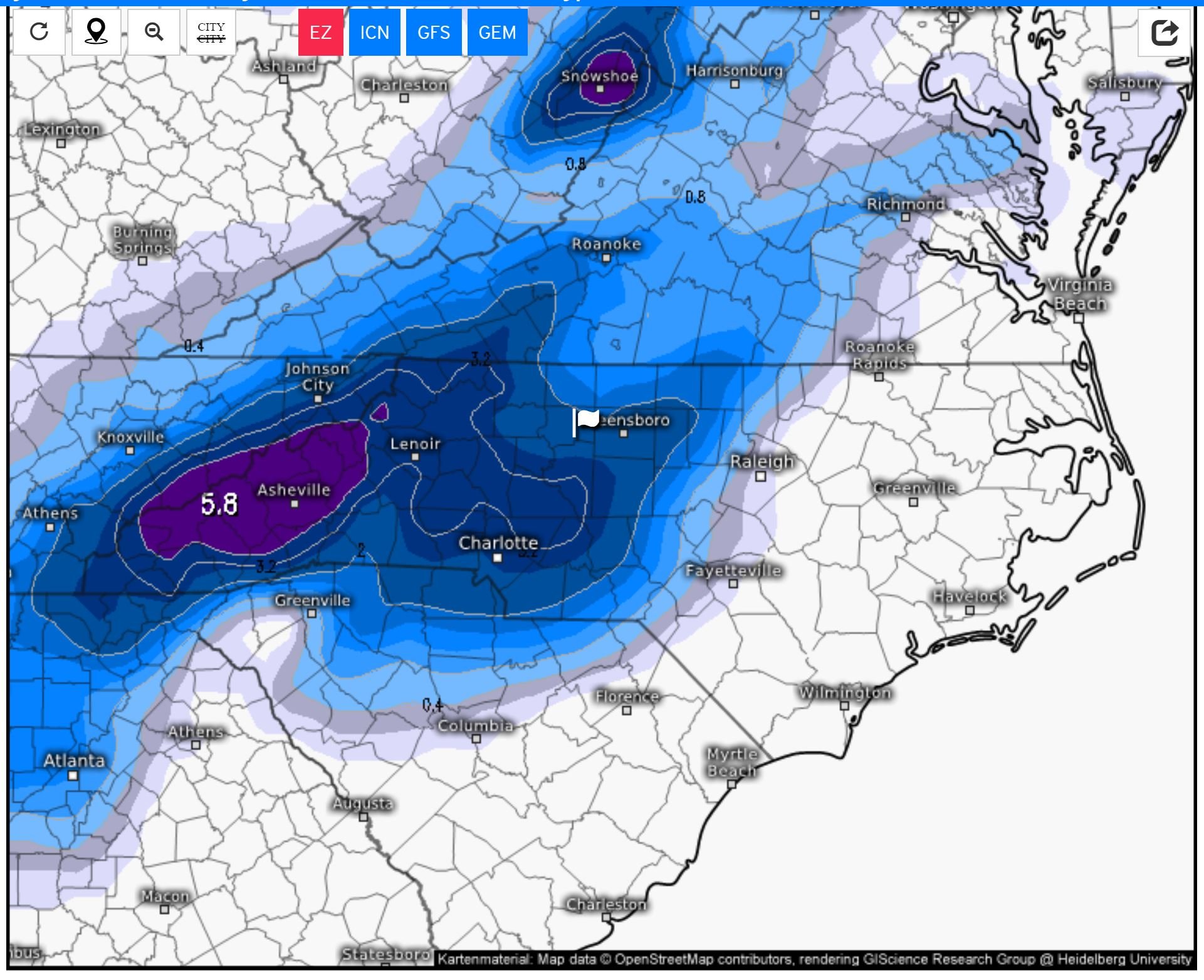
 no real changes---maybe a little less in upstate into piedmont areas
-
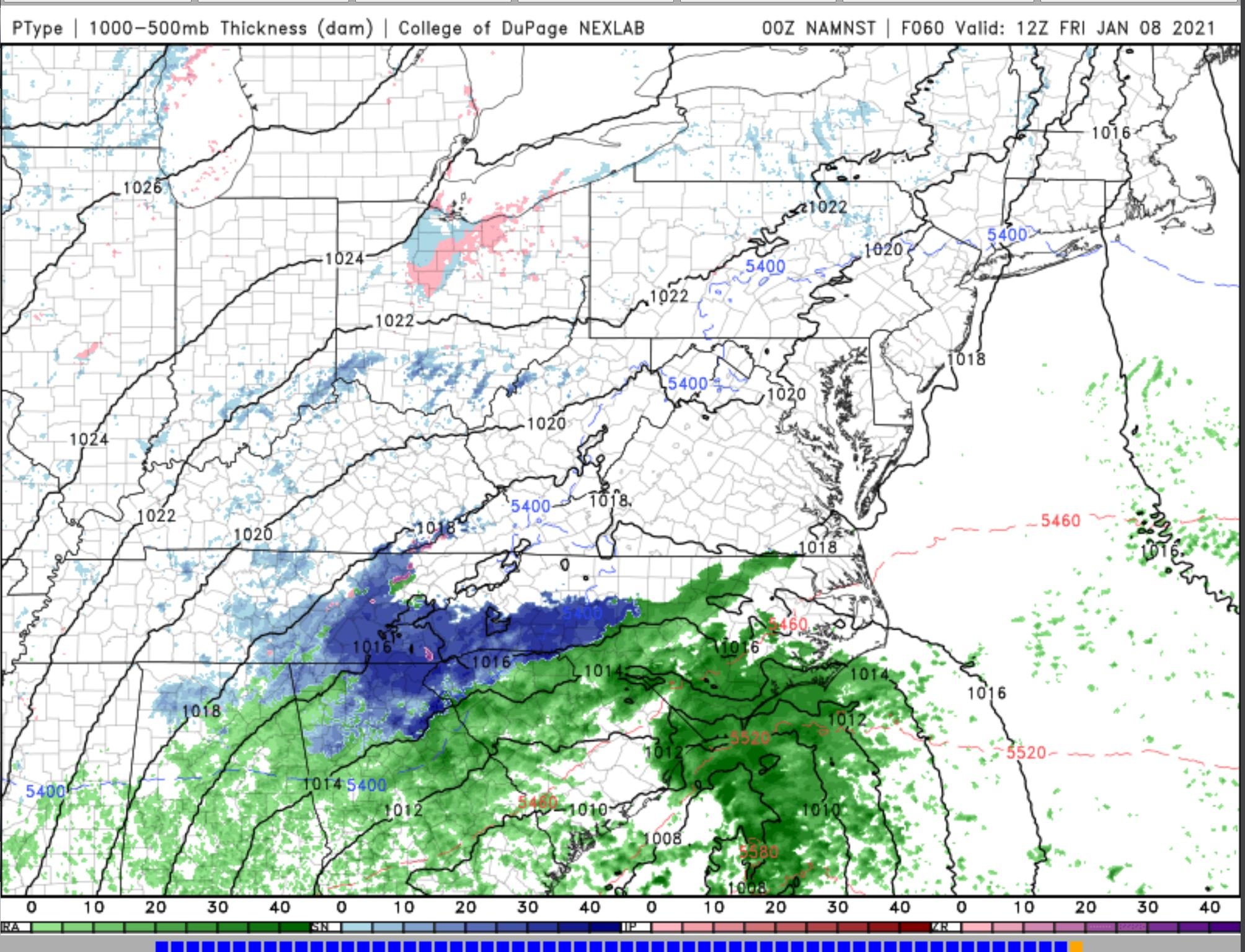
2 minutes ago, ILMRoss said:
Some thoughts:
- I would not rely on the 12km NAM precip shield depiction. Something I first noticed tracking that early Jan 2018 coastal is that it is pretty terrible and inconsistent at rendering these things, with a lot of features that aren't supported by synoptics/surface features. I think they're fun to look at but I don't take them very seriously. I trust the 3km depiction more.
- Flipside: I think somebody is going to get dry-slotted and shafted. Don't know who, but it's just the nature of these transfers of lows from inland to the coast.
- 3km NAM is showing the "splotchy" nature of the precip shield really well- that's how it will turn out! It will be feast or famine! One lucky locale may even see a little thundersnow, not out of the question! Don't know who.
I agree with your mention of dry slot and any transfer. It will be interesting to see how the upcoming 00Z operational Euro depicts event
-
Sharp gradient with snow and none in Piedmont areas
-
-
Not much with EURO ensembles for central NC--I hate this. We shall see this afternoon. One member (#41)---from 00Z December 20----the most I saw from the 50 members. Most of the others show very little. This #41 will skew the ensemble averages. https://weather.us/model-charts/euro/north-carolina/m50_snow-depth-in/20201227-0600z.html.
-
12Z GFS. A no go for snow. The front is a litter faster in pulling thru too. No apparent wave of low pressure

-
This system bears watching, as a wave of low pressure MAY ride along front.
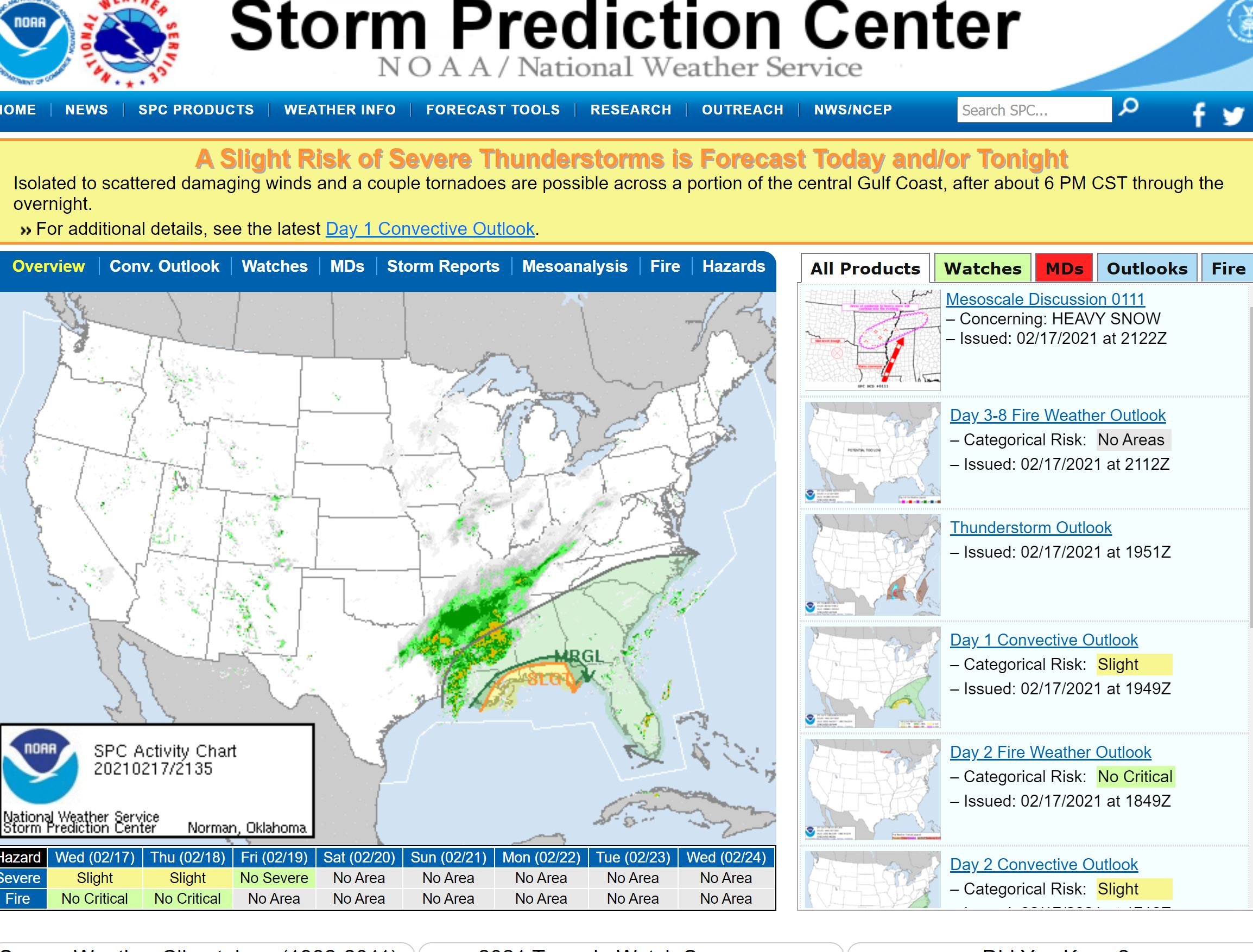


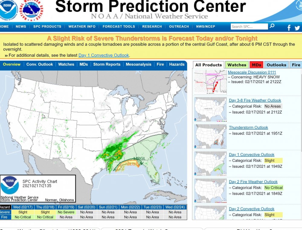
March 17-18 Severe Weather Event
in Southeastern States
Posted
I was thinking about this event yesterday and comparing it today. March 28 and 29, 2010 North Carolina Tornado Outbreak (ncsu.edu)
Some of you may remember this event